Advertisement
If you have a new account but are having problems posting or verifying your account, please email us on hello@boards.ie for help. Thanks :)
Hello all! Please ensure that you are posting a new thread or question in the appropriate forum. The Feedback forum is overwhelmed with questions that are having to be moved elsewhere. If you need help to verify your account contact hello@boards.ie
Help Keep Boards Alive. Support us by going ad free today. See here: https://subscriptions.boards.ie/.
If we do not hit our goal we will be forced to close the site.

Current status: https://keepboardsalive.com/

Annual subs are best for most impact. If you are still undecided on going Ad Free - you can also donate using the Paypal Donate option. All contribution helps. Thank you.
https://www.boards.ie/group/1878-subscribers-forum

Private Group for paid up members of Boards.ie. Join the club.

Unbuilt road projects/unused land reservations

  • 21-10-2024 09:35PM
    #1
    Registered Users, Registered Users 2 Posts: 540 ✭✭✭


    Curious as to how many land reservations/alignments there are around the country there are for road projects that were never built. A well known one would be the J8 M7 extension, or the Eastern Bypass around Sandyford, but I’m sure I’ve read about others but can’t find any info on them, probably as they have been released from reservation and developed.


Comments

  • Registered Users, Registered Users 2 Posts: 540 ✭✭✭dublincc2


    Anyone have a list or links etc


  • Registered Users, Registered Users 2 Posts: 19,054 ✭✭✭✭murphaph


    All along the Greenhills Road in Tallaght you can see this was supposed to be much more.


  • Registered Users, Registered Users 2 Posts: 73,864 ✭✭✭✭L1011


    Some is going to be used in the Busconnects corridor, I think.

    OP would need to check council development plans going back to the late 60s onwards to find any sterilised corridors marked there. I seriously doubt anyone already has. Most of those are only viewable in physical libraries.

    Even finding ones that would definitely have been online - from the early 00s or late 90s - is near impossible now.


  • Registered Users, Registered Users 2 Posts: 8,026 ✭✭✭GerardKeating


    One that I know of would be for the Galway Outer Ring road. Origional route was abandonded a few years ago, and a new route chosen, but still years away from approval.


  • Registered Users, Registered Users 2 Posts: 522 ✭✭✭Limerick74


    were any lands purchased in advance of statutory process for the outer bypass? No limestone pavement for sure


  • Advertisement
  • Registered Users, Registered Users 2 Posts: 522 ✭✭✭Limerick74


    There are some strips of land between Buttevant and Charleville that were acquired for a pre M20 scheme in early 2000s I’d say


  • Registered Users, Registered Users 2, Paid Member Posts: 2,820 ✭✭✭KrisW1001


    Is this what you're talking about? Looks like enough to widen the road to add passing lanes, but nothing like enough for separated carriagways.

    image.png

    [Source: Map - LDA ]


  • Registered Users, Registered Users 2 Posts: 8,026 ✭✭✭GerardKeating


    No, just the owner prevents from doing anything for a few decades.


  • Registered Users, Registered Users 2 Posts: 1,381 ✭✭✭pigtown


    Large sections of the R513 between Limerick and Mitchelstown have had the fencing set back for decades but the road widening never followed


  • Registered Users, Registered Users 2 Posts: 6,215 ✭✭✭Chris_5339762


    Its a real shame that, the whole route should be good S2.


  • Advertisement
  • Registered Users, Registered Users 2 Posts: 26,323 ✭✭✭✭Larbre34


    I know its cumbersome, but if you go through the County Development plan maps of each County; road reservations are delineated clearly, with a key as to whether they are 6 year (lifetime of a CDP) or long-term, which may mean never.

    I have some knowledge of project management in this field, and as such I highly doubt there is a national database of such things. Yes, TII, probably do have a GIS file of all of their reservations, but they only do national routes and motorways, not regional and local, which might actually add up to be the lion's share of all road objectives nationally.


  • Registered Users, Registered Users 2 Posts: 540 ✭✭✭dublincc2


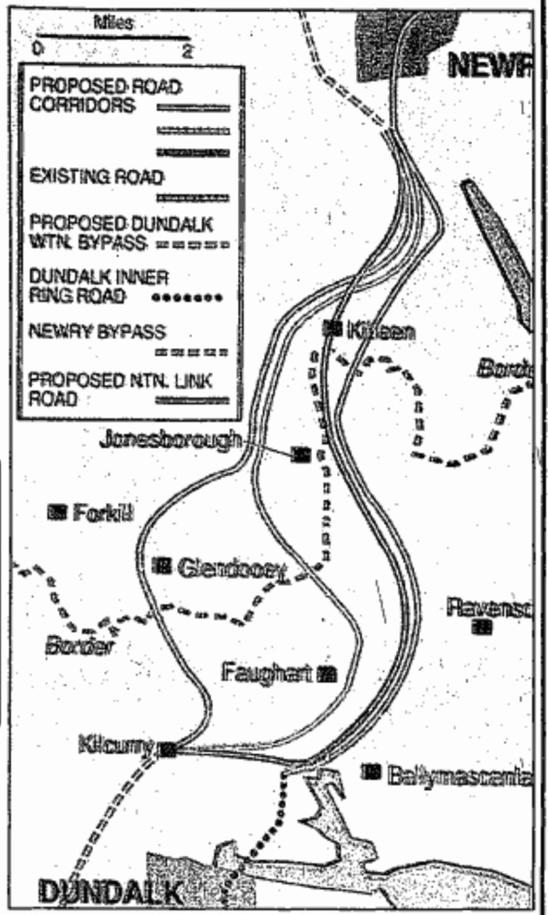
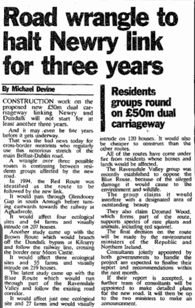
    The original planned route of the Dundalk-Newry DC/motorway was to go north from Kilcurry, cross the border east of Forkhill and link up with the A1 at Cloghoge.

    In the event they of course built the N1 through Ravensdale, cannibalising part of the old N1 in the process meaning the route can’t be designated as motorway. Would’ve been better to use the original route, but that train has passed.

    IMG_2977.jpeg IMG_2978.jpeg


  • Registered Users, Registered Users 2 Posts: 19,925 ✭✭✭✭road_high


    the old N8 north of Abbeyleix (now N77) has a nice chunk of land like this, fenced off decades ago. I think at this stage it’s been reincorporated back into farmland. With the M8 motorway I doubt it would be justified now although it’s still a very busy road


  • Registered Users, Registered Users 2 Posts: 6,720 ✭✭✭Charles Babbage


    A route close to the railway was favoured. However, the NI authorities did not want more road to maintain and they were wary in those days of more road in a region where there would not be road patrols.

    The current route does subsume part of the old road, but this does not prevent it being a motorway, there is a parallel minor road.


Advertisement