Advertisement
If you have a new account but are having problems posting or verifying your account, please email us on hello@boards.ie for help. Thanks :)
Hello all! Please ensure that you are posting a new thread or question in the appropriate forum. The Feedback forum is overwhelmed with questions that are having to be moved elsewhere. If you need help to verify your account contact hello@boards.ie
Hi there,
There is an issue with role permissions that is being worked on at the moment.
If you are having trouble with access or permissions on regional forums please post here to get access: https://www.boards.ie/discussion/2058365403/you-do-not-have-permission-for-that#latest

Old satellite / aerial imagery

  • 12-01-2024 7:26pm
    #1
    Registered Users, Registered Users 2 Posts: 4,565 ✭✭✭


    Just wondering if anyone has access to old satellite / aerial imagery, particularly from 70s/80s if possible.

    I’m aware of Map Genie. That tantalisingly goes back to about 1995. Purely just for morbid curiosity sake. Interesting to see how a number of cities looked pre-ring road infrastructure etc.


Comments

  • Registered Users, Registered Users 2 Posts: 4,565 ✭✭✭AugustusMinimus


    By the way, my morbid curiosity mainly lies on the South Ring Road in Cork. The 1995 black and white imagery on map genie shows the Kinsske ti Bandon section in construction,

    Snyobe have photos showing the Bloomfield to Bandon Roundabout section either before or in construction?


  • Registered Users, Registered Users 2 Posts: 7,116 ✭✭✭zg3409


    I had or probably still have ordinance survey CD copy that covered all the country around 90s. It was some sort of copy of official data, similar to the hiking maps.


    I suspect your best chance is to go to ordinance survey and ask to see maps. I know they tend to want people to pay for commercial data like a business, but worth asking.

    Also Google maps has a historical feature satellite images going back to mid nineties. You need Google Earth and move some slides to look at older versions.


  • Registered Users, Registered Users 2 Posts: 71,581 ✭✭✭✭L1011


    I'm fairly sure that 1995 survey is the first national aerial survey there was; so anything older is going to be patchy and area specific


  • Registered Users, Registered Users 2 Posts: 548 ✭✭✭coffee to go


    Have a dig around the various “Imagery Collections” sites from here:

    The Cambridge Air Photos one has a georeferenced map, though most if not all the photos are obliques.

    Alternative site of obliques with a searchable map here too (mostly from the 1930s?): https://www.britainfromabove.org.uk/en/map?country=ireland&year=all


  • Registered Users, Registered Users 2 Posts: 548 ✭✭✭coffee to go


    The Geological Survey of Ireland commissioned the National Geographical Institute of France to take vertical aerial photographs (b&w @ 1:30,000) of the whole of Ireland from 1973 to 1977. These images aren’t orthorectified and you have to pay for them from OSI (or GSI?). I don’t think they’re available to preview online.


  • Advertisement
  • Registered Users, Registered Users 2 Posts: 1,391 ✭✭✭yannakis


    Google Earth for Desktop has "historical imagery" that you can access from the View menu at the top bar.

    Keep in mind the available imagery changes depending on the zoom level.

    Example from Dublin Airport:


    Another example from Ashtown:


  • Registered Users, Registered Users 2 Posts: 4,565 ✭✭✭AugustusMinimus


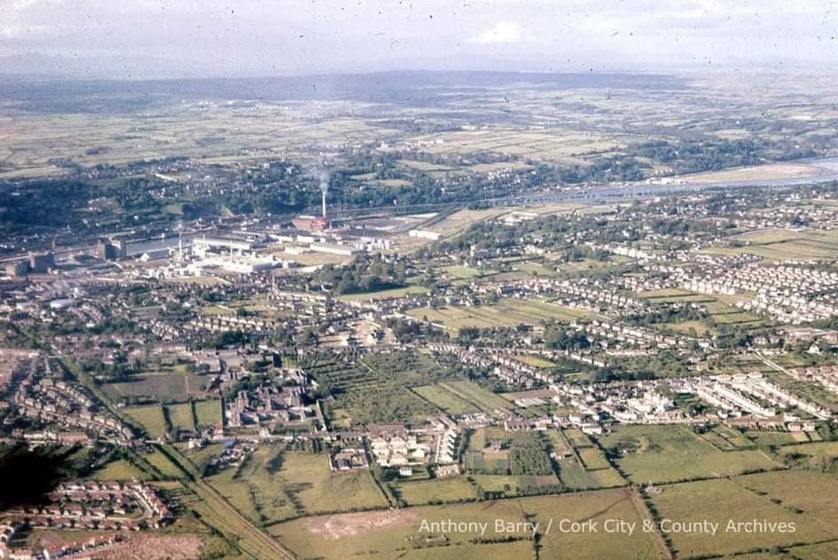
    Thanks everyone. Frustratingly the best open source photography appears to be the 1995 black and white photos on map genie.

    Been looking for old photos of Cork City Out of interest, below shows the south link road in Cork before construction. Shows the old rail line. For reference, the estate in the bottom left hand corner is Mercier Park in Turners Cross. Any more imagery like this would be great.


  • Registered Users, Registered Users 2 Posts: 1,542 ✭✭✭cjpm


    @AugustusMinimus

    There’s an old Photos FB page which you may or may not know about…..


  • Registered Users, Registered Users 2 Posts: 42 neiljung


    What's the development/buildings on the site of Mahon Point, due East of the CSO?


  • Registered Users, Registered Users 2 Posts: 2,146 ✭✭✭KrisW1001


    Completely gone now: it's the empty ground beside the most westerly car park for Mahon Park SC.

    Could it have been site offices for the Lee Tunnel project? The tunnel opened in 1999, and most of the works were on this side of the river.


  • Advertisement
  • Registered Users, Registered Users 2 Posts: 676 ✭✭✭DylanQuestion


    It's crazy for a city over 100 years old that most of its growth happened in the last 50-75 years


  • Moderators, Recreation & Hobbies Moderators, Science, Health & Environment Moderators, Technology & Internet Moderators Posts: 93,857 Mod ✭✭✭✭Capt'n Midnight


  • Registered Users, Registered Users 2 Posts: 62 ✭✭Modulok


  • Moderators, Social & Fun Moderators Posts: 13,198 Mod ✭✭✭✭JupiterKid


    NCAP - UK and Ireland aerial photography from the mid to late 20th century.

    Link:

    Contains a collection of vertical aerial photos of Dublin from 1971, 1993 and 1999. Some of these feature sections of the M50 motorway under construction.

    Finglas, October 1971


  • Moderators, Social & Fun Moderators Posts: 13,198 Mod ✭✭✭✭JupiterKid


    Blanchardstown, 1971


  • Moderators, Social & Fun Moderators Posts: 13,198 Mod ✭✭✭✭JupiterKid


    M50 Westlink toll bridge at Strawberry Beds between junction 6 and 7, September 1993


  • Moderators, Social & Fun Moderators Posts: 13,198 Mod ✭✭✭✭JupiterKid


    Dublin Airport, October 1971

    Terminal 1 was still under construction but the B gates carousel is already in operation to serve the new Aer Lingus Boeing 747 Jumbo Jet.


  • Moderators, Social & Fun Moderators Posts: 13,198 Mod ✭✭✭✭JupiterKid


    Castkeknock, October 1971

    The rural west Dublin village is beginning to develop rapidly as a new suburb like nearby Blanchardstown.


  • Moderators, Social & Fun Moderators Posts: 13,198 Mod ✭✭✭✭JupiterKid


    Leixlip, October 1971


  • Moderators, Social & Fun Moderators Posts: 13,198 Mod ✭✭✭✭JupiterKid


    M50 Southern Cross section under construction at Rathfarnham and Ballinteer, 1999


  • Advertisement
  • Moderators, Social & Fun Moderators Posts: 13,198 Mod ✭✭✭✭JupiterKid


    Oblique aerial photo of southwestern Dublin with Rathfarnham in the foreground and newly developing Tallaght at upper right, September 1972


  • Moderators, Social & Fun Moderators Posts: 13,198 Mod ✭✭✭✭JupiterKid


    High resolution vertical aerial photo of Tallaght, June 1973


  • Registered Users, Registered Users 2 Posts: 71,581 ✭✭✭✭L1011


    Interesting to see a few bits of the bypass are laid out already, North of Glenview Drive for instance


  • Moderators, Social & Fun Moderators Posts: 13,198 Mod ✭✭✭✭JupiterKid


    Oblique aerial photo of Ballymount and Greenhills, 1975

    The M50 runs right through the area from upper left to lower right today.

    Kilnamanagh estate in Tallaght is under construction to the left with Greenhills Road running across the image from middle left to upper RHS.


  • Moderators, Social & Fun Moderators Posts: 13,198 Mod ✭✭✭✭JupiterKid


    M50 Westlink toll bridge under construction, 1989


    Post edited by JupiterKid on


  • Moderators, Social & Fun Moderators Posts: 13,198 Mod ✭✭✭✭JupiterKid


    OP - in addition to the NCAP website I posted a link to above, another really good resource is the Leo Swan aerial photographic archive, linked here below:


    Leo Swan was a pilot, archaeologist and school principal who flew light aircraft and took many oblique colour and B&W aerial photos of sites of historical interest, but his extensive collection also features many images of Dublin and other parts of Ireland from the early 1970s to the late 1980s.


  • Moderators, Social & Fun Moderators Posts: 13,198 Mod ✭✭✭✭JupiterKid


    Oblique aerial photo of Navan, 1982


  • Moderators, Social & Fun Moderators Posts: 13,198 Mod ✭✭✭✭JupiterKid


    Aerial photo of Naas Road at Bluebell, 1955


    Only 1 km of DC (built circa 1944) is there, area was very rural in 1955 but the Volkswagen factory near the centre of the image is newly built. Long Mile Road is at lower right.


  • Registered Users, Registered Users 2 Posts: 863 ✭✭✭corm500


    I think the building down at the bottom of the photo was a Chinese restaurant called Wongs back in the seventies


  • Advertisement
  • Registered Users, Registered Users 2 Posts: 71,581 ✭✭✭✭L1011


    Its the petrol station that's still there today, but a completely different building. This was an interesting drive-through covered structure

    https://twitter.com/AnFearBui/status/1678590581356781568/photo/1


Advertisement