Advertisement
If you have a new account but are having problems posting or verifying your account, please email us on hello@boards.ie for help. Thanks :)
Hello all! Please ensure that you are posting a new thread or question in the appropriate forum. The Feedback forum is overwhelmed with questions that are having to be moved elsewhere. If you need help to verify your account contact hello@boards.ie
Hi there,
There is an issue with role permissions that is being worked on at the moment.
If you are having trouble with access or permissions on regional forums please post here to get access: https://www.boards.ie/discussion/2058365403/you-do-not-have-permission-for-that#latest

A6 dualling - Dungiven to Drumahoe [under construction]

  • 04-11-2018 1:16am
    #1
    Moderators, Social & Fun Moderators Posts: 13,102 Mod ✭✭✭✭


    This long-awaited major road scheme, the A6 Derry to Drumahoe dualling which includes the Dungiven bypass has seen earthworks begin in the past month. This is the biggest road scheme in Northern Ireland since work finished on the A8 Larne to Corrs Corner scheme in 2014.

    The project entails 30km of high quality GSJ dual carriageway and work is expected to be complete in 2021. This means that construction on two major road improvement schemes on the A6 from Belfast to Derry is underway. The other major scheme, the A6 dualling from Randalstown to Castledawson, is well advanced and is expected to open to traffic late next year.

    Link below (Wesley Johnston’s excellent NI roads site):
    http://www.wesleyjohnston.com/roads/a6dungiventoderry.html


Comments

  • Moderators, Science, Health & Environment Moderators Posts: 5,226 Mod ✭✭✭✭spacetweek


    Great news altogether - the lack of a dual carriageway between Belfast and Derry is an oddity.


  • Registered Users, Registered Users 2 Posts: 667 ✭✭✭BelfastVanMan


    spacetweek wrote: »
    Great news altogether - the lack of a dual carriageway between Belfast and Derry is an oddity.

    The Glenshane Pass between Castledawson Roundabout and Dungiven will remain SC, albeit with overtaking lanes fairly frequently along its length.

    I suspect it will be many years before this stretch is dualled.


  • Registered Users, Registered Users 2 Posts: 1,072 ✭✭✭riddlinrussell


    The Glenshane Pass between Castledawson Roundabout and Dungiven will remain SC, albeit with overtaking lanes fairly frequently along its length.

    I suspect it will be many years before this stretch is dualled.

    Its a far quieter stretch of the road than either side, will definitely need the works on both ends completed before we can see what effect it has on traffic, likely see an uptick in intercity transit in the coming years. I'd say more pressing will be some solution to get from Drumahoe into Derry (huge illegal rubbish dump means its not getting done with this bit) and fixing the monumentally stupid Idea to retain two roundabouts in succession on the other section (both at toome) along with the Castledawson roundabout at the end of that section.


  • Registered Users, Registered Users 2 Posts: 6,064 ✭✭✭Chris_5339762


    The Glenshane Pass between Castledawson Roundabout and Dungiven will remain SC, albeit with overtaking lanes fairly frequently along its length.

    I suspect it will be many years before this stretch is dualled.


    Agreed. Plus Glenshane would be monumentally expensive to upgrade.


  • Moderators, Entertainment Moderators, Science, Health & Environment Moderators Posts: 14,523 Mod ✭✭✭✭marno21


    spacetweek wrote: »
    Great news altogether - the lack of a dual carriageway between Belfast and Derry is an oddity.
    I don't find it odd at all - all the road improvements to date have been in the east of NI - and I don't think I need to explain why.

    It's fantastic that this is going ahead though - in stark contrast to the repeated A5 shenanigans.


  • Advertisement
  • Registered Users, Registered Users 2 Posts: 2,081 ✭✭✭theguzman


    Would this be something which resulted from the DUP's Auction politics to prop up Theresa May or was it planned anyway?


  • Registered Users, Registered Users 2 Posts: 667 ✭✭✭BelfastVanMan


    theguzman wrote: »
    Would this be something which resulted from the DUP's Auction politics to prop up Theresa May or was it planned anyway?

    It has been planned for years.


  • Registered Users, Registered Users 2 Posts: 3,284 ✭✭✭dubhthach


    spacetweek wrote: »
    Great news altogether - the lack of a dual carriageway between Belfast and Derry is an oddity.

    Well it's the same reason why the University of Ulster was originally situated in Coleraine (before additional campus's were added), a look at the census data could point to a reason...


  • Registered Users, Registered Users 2 Posts: 3,284 ✭✭✭dubhthach


    marno21 wrote: »
    I don't find it odd at all - all the road improvements to date have been in the east of NI - and I don't think I need to explain why.

    It's fantastic that this is going ahead though - in stark contrast to the repeated A5 shenanigans.

    Well I would thought it was obviously why Dungannon got a motorway connection to Belfast first over Derry, even though Derry is second biggest city in the North.


  • Registered Users, Registered Users 2 Posts: 667 ✭✭✭BelfastVanMan


    Earthworks at Foreglen, County Derry.


  • Advertisement
  • Registered Users, Registered Users 2 Posts: 3,020 ✭✭✭xabi


    dubhthach wrote: »
    Well I would thought it was obviously why Dungannon got a motorway connection to Belfast first over Derry, even though Derry is second biggest city in the North.

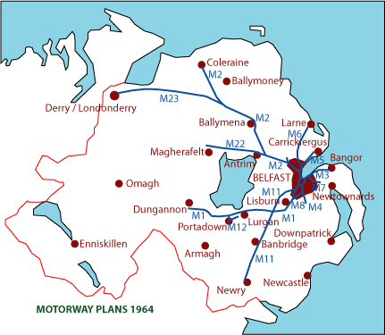
    In the original motorway plan in the 60's 70's, the Belfast - Derry route was via Ballymena and coleraine rather than the more obvious route through County Derry.

    Map-Northern-Ireland-Plans-1964.gif


  • Registered Users, Registered Users 2 Posts: 3,284 ✭✭✭dubhthach


    xabi wrote: »
    In the original motorway plan in the 60's 70's, the Belfast - Derry route was via Ballymena and coleraine rather than the more obvious route through County Derry.

    Map-Northern-Ireland-Plans-1964.gif

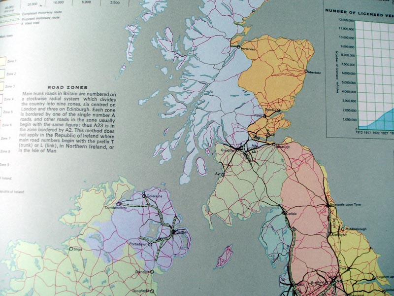
    Indeed on the Sabre site they have a map from 1965 showing project routes in Northern Ireland/Scotland
    Projected_roads_in_Scotland_and_Northern_Ireland%2C_1965_-_Coppermine_-_14505.jpg

    I imagine the following would have applied

    1. Easier pushing motorway north and not have to deal with Glenshane Pass (and Sperrins in general)
    2. By servicing Ballymena/Ballymoney and Coleraine the NI gov would have kept their political base happy.


  • Moderators, Entertainment Moderators, Science, Health & Environment Moderators Posts: 14,523 Mod ✭✭✭✭marno21


    Some pics of early work on the A6 scheme

    https://twitter.com/paulmccloskey12/status/1119598114413977601


  • Registered Users, Registered Users 2 Posts: 574 ✭✭✭Aontachtoir


    dubhthach wrote: »
    By servicing Ballymena/Ballymoney and Coleraine the NI gov would have kept their political base happy.

    Illustrative of the days when NI was a Protestant state for a Protestant people, with its own fully unionist government and prime minister - the motorway to the second largest city in the country was to be the M23 and the one to wee Coleraine was to be the M2. :)

    Also, thank you for the map - it finally makes sense why the Ballymena bypass is the M2 even though it is 11 km away from the other M2 (which runs directly into the M22...)! A very interesting look at what could have been.


  • Moderators, Entertainment Moderators, Science, Health & Environment Moderators Posts: 14,523 Mod ✭✭✭✭marno21


  • Registered Users, Registered Users 2 Posts: 1,072 ✭✭✭riddlinrussell


    There are more pictures and information on scheme progress on Wesleys website.

    http://www.wesleyjohnston.com/roads/a6dungiventoderry.html#updates


  • Registered Users, Registered Users 2 Posts: 1,108 ✭✭✭nordydan


    Alignment fully clear now on Google Maps satellite view:

    https://www.google.com/maps/@54.947059,-7.0695321,10634m/data=!3m1!1e3


  • Registered Users, Registered Users 2 Posts: 4,739 ✭✭✭serfboard


    nordydan wrote: »
    Alignment fully clear now on Google Maps satellite view
    Good stuff. And if you go further east on the A6, the Satellite view also shows the alignment of the Randalstown to Castledawson scheme.

    Does anyone know (or give a good estimate of) how much single-carriageway A6 will be left when both of these schemes are complete?


  • Registered Users, Registered Users 2 Posts: 667 ✭✭✭BelfastVanMan


    serfboard wrote: »
    Good stuff. And if you go further east on the A6, the Satellite view also shows the alignment of the Randalstown to Castledawson scheme.

    Does anyone know (or give a good estimate of) how much single-carriageway A6 will be left when both of these schemes are complete?

    From the new Magherabuoy Roundabout, at the eastern side of Dungiven, to Castledawson Roundabout will remain as mostly 2+1 Single Carriageway.

    Roughly about 15 miles at most, so.. 24, 25 kms. approx.


  • Registered Users, Registered Users 2 Posts: 6,064 ✭✭✭Chris_5339762


    ...Very very expensive to fix that, as the Glenshane Pass is in the way.


  • Advertisement
  • Registered Users, Registered Users 2 Posts: 1,072 ✭✭✭riddlinrussell


    ...Very very expensive to fix that, as the Glenshane Pass is in the way.

    Its a fairly quiet section as well, and with the passing lanes I cant see it being high priority for a long time in NI;
    • A1 deathtrap junction fixes
    • A6
    • Town Bypasses (Newry East, Ballynahinch, Enniskillen, Cookstown, North Derry improvements)
    • Eventually they will have to deal with europes largest illegal dump and finish the A5 link to A2 at Derry
    • York Street Interchange will rear its head again in some more pedestrian severance friendly form
    All of those at a minimum would likely have higher priority than A6 Glenshane.

    Given the shift in thinking towards PT I could see it never getting done (at least not according to any 'current' thinking on road construction).


  • Registered Users, Registered Users 2 Posts: 1,108 ✭✭✭nordydan


  • Registered Users, Registered Users 2 Posts: 1 mopen1571


    Does anyone know if there is parking near the new magherabuoy roundabout at Dungiven as roadworks have closed the usual bus stop.


  • Registered Users, Registered Users 2 Posts: 1,108 ✭✭✭nordydan


    As per above Dungiven bypass section openend last week


  • Moderators, Social & Fun Moderators Posts: 13,102 Mod ✭✭✭✭JupiterKid


    Absolutely delighted that Dungiven is finally bypassed 45 years after early plans for a bypass were drawn up. The small Derry town will get its town centre back from heavy through traffic.

    This is the first 1.6 miles (2.5 kilometres) of the major 17 km Derry to Dungiven Road project. The remainder is very close to completion and will open to traffic in the Summer. Along with the A6 dualling from Randalstown to Castledawson scheme fully open since last year, this scheme will cut Belfast to Derry journey times and make the road much safer.


  • Registered Users, Registered Users 2 Posts: 1,391 ✭✭✭yannakis


    Is the section from Dungiven to Claudy still closed? Any sign of when it'll be opening?


  • Registered Users, Registered Users 2 Posts: 3,020 ✭✭✭xabi


    Dungiven to Claudy is still closed, due to open fully in April.


  • Registered Users, Registered Users 2 Posts: 1,391 ✭✭✭yannakis


Advertisement