Advertisement
If you have a new account but are having problems posting or verifying your account, please email us on hello@boards.ie for help. Thanks :)
Hello all! Please ensure that you are posting a new thread or question in the appropriate forum. The Feedback forum is overwhelmed with questions that are having to be moved elsewhere. If you need help to verify your account contact hello@boards.ie
Hi there,
There is an issue with role permissions that is being worked on at the moment.
If you are having trouble with access or permissions on regional forums please post here to get access: https://www.boards.ie/discussion/2058365403/you-do-not-have-permission-for-that#latest

Howth Cliff Walk.... a question or two for those who know!

  • 27-09-2015 5:58pm
    #1
    Registered Users, Registered Users 2 Posts: 16,059 ✭✭✭✭


    Hi,

    I don't do UPHILLS lol, so was thinking of starting at the Summit and going anti clockwise and ending up in Howth via Balscadden Road. That's downhill, so looks good!

    Is the path signposted at the Summit Car park?

    Many thanks.


Comments

  • Closed Accounts Posts: 9,700 ✭✭✭tricky D


    It's easily found. Just head to the left side of the house on the far side from the entrance down the driveable path, take one of the immediate right paths and you'll be down on the outer cliff walk in no time. (Coords 53°22'14.88"N 6° 3'13.61"W) Mind you the walk up to the Summit car park is uphill though not long. Just don't do anything stupid like going off-path - another casualty winched off this afternoon.


  • Registered Users, Registered Users 2 Posts: 16,059 ✭✭✭✭Spanish Eyes


    BowWow wrote: »

    thanks! How did you get that? My google maps streetview doesn't go under the car park barrier. What am I doing wrong here!


  • Registered Users, Registered Users 2 Posts: 16,059 ✭✭✭✭Spanish Eyes


    tricky D wrote: »
    It's easily found. Just head to the left side of the house on the far side from the entrance down the driveable path, take one of the immediate right paths and you'll be down on the outer cliff walk in no time. (Coords 53°22'14.88"N 6° 3'13.61"W) Mind you the walk up to the Summit car park is uphill though not long. Just don't do anything stupid like going off-path - another casualty winched off this afternoon.

    Thanks tricky D. Looking at the google maps there are two paths from the Summit, one that goes down to Upper Cliff Road and Thormanby rd, and the other is the cliff path.

    From what you say, I should keep right and forget the first path.

    Just wondered if there was a sign for the cliff path.

    Thanks again. Downhill all the way so!! Getting the oul bus to the Summit so no uphills.... gasp, and the DART back, if I find my way ok!

    Heard it is a great walk, so I'm really looking forward to it. And I will not stray from the path either


  • Closed Accounts Posts: 9,700 ✭✭✭tricky D


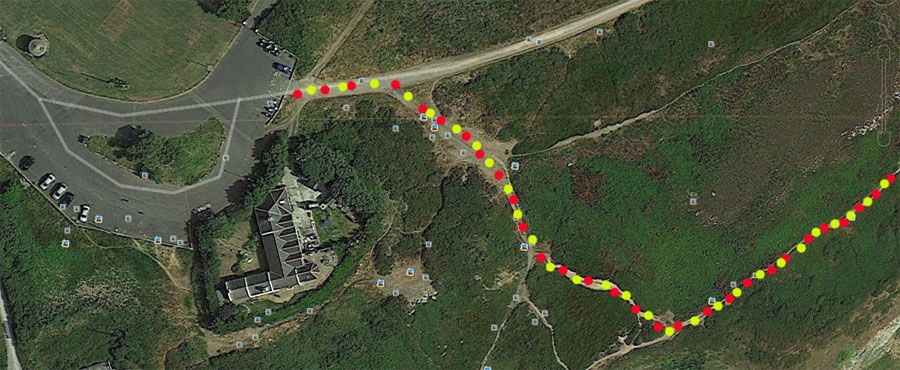
    Forget the Upper Cliff Road unless you have acrophobia - there's poor views relatively speaking. There's also a middle path, but for non-locals it's easy to get a bit lost and is thick with briars, nettles and the like in places.

    Just follow the yellow/red dotted path in this...

    summit-cliff-path1_zps4xhk6xwj.jpg


  • Advertisement
  • Registered Users, Registered Users 2 Posts: 16,059 ✭✭✭✭Spanish Eyes


    tricky D wrote: »
    Forget the Upper Cliff Road unless you have acrophobia - there's poor views relatively speaking. There's also a middle path, but for non-locals it's easy to get a bit lost and is thick with briars, nettles and the like in places.

    Just follow the yellow/red dotted path in this...

    summit-cliff-path1_zps4xhk6xwj.jpg

    That is exactly where I want to go. I could see it on the maps, but wasn't sure if I would take the wrong turn when on the ground so to speak! Your pic is very clear.

    Thank you very much. I appreciate your guidance.


  • Closed Accounts Posts: 9,700 ✭✭✭tricky D


    Oh and fwiw there was another incident just below the pic above later in the afternoon.


  • Registered Users, Registered Users 2 Posts: 16,059 ✭✭✭✭Spanish Eyes


    tricky D wrote: »
    Oh and fwiw there was another incident just below the pic above later in the afternoon.

    Sorry for the injured.

    Is the cliff path that dangerous?


  • Closed Accounts Posts: 9,700 ✭✭✭tricky D


    If you stick to the path, you'll have no problems at all.

    The very badly injured one is at the end of the path (north and off main path). He went down an extremely dangerous path on a cliff face to a fishing spot.

    The other one below the pic (south and off main path) got lost on the way back up from a 'secret spot' and ended up stuck on a cliff face with no way up or down.

    Both of these people went off the regular cliff paths which are quite safe as long as you stick to them and no gale is blowing. Almost every incident around Howth cliffs is due to stupidity or is a 'tragic incident'. It's extremely rare for a regular walker to get into trouble on the beaten paths. I can only recall a twisted/broken ankle or two which would more of a pure accident than otherwise.


    http://www.thejournal.ie/man-serious-condition-2354868-Sep2015/
    http://www.howthcoastguard.com/news/cliff-rescues-on-howth-head


  • Registered Users, Registered Users 2 Posts: 16,059 ✭✭✭✭Spanish Eyes


    tricky D wrote: »
    If you stick to the path, you'll have no problems at all.

    The very badly injured one is at the end of the path (north). He went down an extremely dangerous path on a cliff face to a fishing spot.

    The other one below the pic (south) got lost on the way back up from a 'secret spot' and ended up stuck on a cliff face with no way up or down.

    Both of these people went off the regular cliff paths which are quite safe as long as you stick to them and no gale is blowing.


    http://www.thejournal.ie/man-serious-condition-2354868-Sep2015/
    http://www.howthcoastguard.com/news/cliff-rescues-on-howth-head

    OK so. I have no intention of visiting any secret spots. Just want to walk the path and see the amazing views.

    Thank you again. You have been very helpful.


  • Advertisement
  • Registered Users, Registered Users 2 Posts: 1,791 ✭✭✭BowWow


    thanks! How did you get that? My google maps streetview doesn't go under the car park barrier. What am I doing wrong here!

    Just went into "Maps", then satellite view, then dropped the "little yellow man" into the middle of the car-park :)


  • Registered Users, Registered Users 2 Posts: 3,292 ✭✭✭0lddog


    Hi,
    .........was thinking of starting at the Summit and going anti clockwise and ending up in Howth via Balscadden Road. That's downhill, so looks good!......

    IMHO Summit to Red Rock or even as far as Martello Tower is much nicer esp. if wind is from north - east.


  • Registered Users, Registered Users 2 Posts: 16,059 ✭✭✭✭Spanish Eyes


    0lddog wrote: »
    IMHO Summit to Red Rock or even as far as Martello Tower is much nicer esp. if wind is from north - east.

    I can't see Red Rock on the map, but I'm presuming you mean the path past the Baily and parrallel to Carrickbrack Road, that takes you to the Martello Tower at Sutton?

    Is the path DOWNHILL lol, I think it is, and is it SAFE.

    I'm no spring chicken, love walking but am not into needing walking poles or heavy boots!

    Many thanks.


  • Closed Accounts Posts: 9,700 ✭✭✭tricky D


    Red Rock is between Ceanchor/Censure and the Sutton Martello Tower.


  • Registered Users, Registered Users 2 Posts: 3,292 ✭✭✭0lddog


    Its more or less downhill / flat until Redrock then there is a bit of uphill ( to get above sea level :), once past Redrock its more or less flat.

    Have a look at https://www.youtube.com/watch?v=jnjiRROMkAg starting at about 2:00 ( near the summit ) from the begining. Red rock is at around 4:30.

    For starters you could try a short down hill part of this walk from The Summit to Ceanchor Road.

    Do you have a driver that you can summon to pick you up ? :D


  • Registered Users, Registered Users 2 Posts: 20,085 ✭✭✭✭neris


    If your into walks on the Peninsula another one is not on the cliffs but a nice walk around Howth/Sutton is up Shielmartin mountain around the top of the hill past the quarry and down into Deer Park


  • Registered Users, Registered Users 2 Posts: 16,059 ✭✭✭✭Spanish Eyes


    Thanks to all who helped me out. Did that walk yesterday with OH. It was a perfect day for walking up there, no wind and great visibility. We were the ONLY ones going in an anti clockwise direction, all the other walkers started at the Balscadden Road. Big hill there, so am glad we took the route we did! I would say it's quite busy on the weekend, as there were lots of people out yesterday.

    I found the path quite narrow in parts, and it was a bit stony underfoot. You would want a bit of a head for heights aswell, some parts are a bit close to the cliff edge, but once you take your time it's fine.

    Had coffee and a bun in the Summit Inn before starting out. Great spot, full of walkers and tourists.

    Might try the other direction towards Sutton the next time.

    Thank you all again.


  • Moderators, Category Moderators, Politics Moderators, Recreation & Hobbies Moderators, Society & Culture Moderators, Regional East Moderators Posts: 12,110 CMod ✭✭✭✭Dizzyblonde


    Glad you enjoyed it - it was great weather for it too :)


  • Registered Users, Registered Users 2 Posts: 18,288 ✭✭✭✭LXFlyer


    OP - it's also worth taking a trip on the 31a bus around the hill - some great views from the top deck.

    It finishes near the Martello Tower in Sutton.


Advertisement