Advertisement
If you have a new account but are having problems posting or verifying your account, please email us on hello@boards.ie for help. Thanks :)
Hello all! Please ensure that you are posting a new thread or question in the appropriate forum. The Feedback forum is overwhelmed with questions that are having to be moved elsewhere. If you need help to verify your account contact hello@boards.ie
Hi there,
There is an issue with role permissions that is being worked on at the moment.
If you are having trouble with access or permissions on regional forums please post here to get access: https://www.boards.ie/discussion/2058365403/you-do-not-have-permission-for-that#latest

strange sand river bank after floods

  • 24-03-2014 1:57pm
    #1
    Registered Users, Registered Users 2 Posts: 689 ✭✭✭


    Hi,

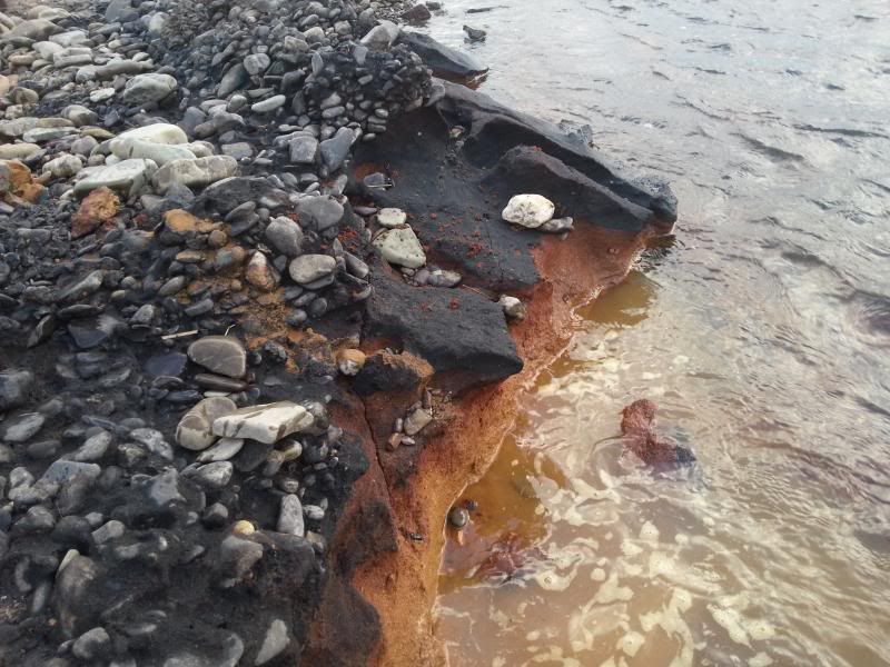
    Can anyone identify this ?

    Its from the Blackwater River, Munster and became exposed after the winter floods. Looks almost like tarmac when you approach it but its sand. Appears to go black exposed to air, and breaks apart when you walk on it, actually pretty dangerous to step on.

    20140317_172955.jpg


Comments

  • Moderators, Science, Health & Environment Moderators Posts: 5,223 Mod ✭✭✭✭slowburner


    At a guess, it looks as though the sand is heavily mineralised and the exposed upper layer is oxidised. Was there any iron working in the vicinity - a mill or some such?
    Whereabouts on the Blackwater?


  • Registered Users, Registered Users 2 Posts: 689 ✭✭✭stylie


    Lombardstown above Mallow. I would say the sand was exposed after about 5-6ft of bank was eroded off the top of it. 2-3ft of top soil and 2-3ft of heavy gravel. I think it might be a few hundred yards long but I have to check the top of the section but I have a feeling it goes up that far. Quite strange but I suppose a mill or iron works upstream in the last few hundred yrs could have laid it down and floods covered it up.


  • Registered Users, Registered Users 2 Posts: 2,081 ✭✭✭GetWithIt


    Looks a lot of Lime Kilns were in the area.

    http://maps.osi.ie/publicviewer/#V1,546352,597744,4,9

    Select Historic Layers and toggle everything on.


  • Registered Users, Registered Users 2 Posts: 689 ✭✭✭stylie


    Certainly was a lot of them. So are we seeing a waste product of that process that was dumped into the river covered up and re-exposed or the river is eroding an area that was used to dump the waste material. Because looking at the bank it looks like the river deposited onto it and now is eroding it. I will take some more pics over the weekend if I'm fishing that section.


Advertisement