Advertisement
If you have a new account but are having problems posting or verifying your account, please email us on hello@boards.ie for help. Thanks :)
Hello all! Please ensure that you are posting a new thread or question in the appropriate forum. The Feedback forum is overwhelmed with questions that are having to be moved elsewhere. If you need help to verify your account contact hello@boards.ie
Hi there,
There is an issue with role permissions that is being worked on at the moment.
If you are having trouble with access or permissions on regional forums please post here to get access: https://www.boards.ie/discussion/2058365403/you-do-not-have-permission-for-that#latest

Old Cork Rail line near Kent Station

  • 17-02-2014 4:07pm
    #1
    Registered Users, Registered Users 2 Posts: 4,564 ✭✭✭


    Hi there. This one has always puzzled me for years.

    As you drive out the Lower Glanmire Road, there is an arch on the left of the road where the rail line runs underneath and enters the tunnel to go to Dublin. As from the link below, you can see there is a very nice stone arch.

    https://maps.google.com/?ll=51.902252,-8.459242&spn=0.000007,0.003449&t=h&z=18&layer=c&cbll=51.902253,-8.460264&panoid=bSjk0ES2nwj4N_E_pEs0SA&cbp=12,356.71,,0,-0.44

    However, above this arch it appears to me that there also used to a rail line running perpendicular to the current one above the arch.

    Looking on google maps, it appears that a train line used to run from where the current Cobh line crosses the Lower Glanmire Road (Cork Dry Gin signed bridge) to roughly just above the church on Summer Hill North.

    If you view the area from above on Google maps, its clear that this area used to be a rail line. Today it is mainly grass areas and or has been tarmacked over.

    The link below shows a nice shot from Lower Grattan Hill. One one side you can see where the rail line has been tarmacked over. The same on the other side. It also looks like where the road is was once a bridge.

    https://maps.google.com/?ll=51.90304,-8.454465&spn=0.000003,0.001725&t=h&z=19&layer=c&cbll=51.90304,-8.454977&panoid=NICVZl3GlHa6vsBQGUJrzA&cbp=12,271.17,,0,-6.24

    One other sure sign that it was a rail line is that on the Lower Glanmire Road, just before the arch mentioned above, theres steps going up from street level and a bridge over where the rail line would have been.

    5ad1x.jpg

    Does anyone know what the purpose of this line was ? I can't work it out. All it would have done would be to feed trains out onto Summer Hill North which surely would have been too steep for trains ?


Comments

  • Registered Users, Registered Users 2 Posts: 16,817 ✭✭✭✭whisky_galore


    It was the site of the Cork & Youghal Railway Summerhill terminus, operated independantly until it was absorbed into the GS&WR and all services then ran out of the one station. Disconnected in the late 20's I think and according to a local, there's rails still down there under nearly a century of earth, rubbish and lawn clippings.


  • Registered Users, Registered Users 2 Posts: 912 ✭✭✭Hungerford


    It shows up on the OSI 25" historic maps as a disused railway. You can clearly see its path there:
    http://maps.osi.ie/publicviewer/#V1,568284,572310,7,9


  • Registered Users, Registered Users 2 Posts: 5,443 ✭✭✭ofcork


    Glanmire road opened in 1893 and the east cork trains ran into this station which is now kent .


  • Registered Users, Registered Users 2 Posts: 3,915 ✭✭✭GTE


    It doesn't seem the most useful thing in the world. I'd hazard a guess it came before the main station?


  • Registered Users, Registered Users 2 Posts: 5,443 ✭✭✭ofcork


    Yes it opened in 1861.


  • Advertisement
  • Closed Accounts Posts: 17,733 ✭✭✭✭corktina


    you should also be aware that the line from the tunnel used to go straight on to the quays where the original station was located before Glanmire Rd/Kent was built to combine the two lines.


  • Registered Users, Registered Users 2 Posts: 1,240 ✭✭✭CaptainSkidmark


    its almost sickening looking at all that railway on the map and never getting to see any of it


  • Registered Users, Registered Users 2 Posts: 16,817 ✭✭✭✭whisky_galore


    corktina wrote: »
    you should also be aware that the line from the tunnel used to go straight on to the quays where the original station was located before Glanmire Rd/Kent was built to combine the two lines.

    Yes, the old Penrose Qy station. The only bits of that left are part of what was the office block near the building formerly used by Guinness and a partly derelict workshop that's in the car park between it and the tunnel.

    The old connection from Penrose Qy to the fomer C&YR alignment used cross over the Lower rd on a bridge close to where 'Constabulary Bks' are marked on Hungerford's map. One set of the stone abutments is still there. Following construction of the present station, a new bridge was built further east at the junction of Lwr Road/Water St.


  • Registered Users, Registered Users 2 Posts: 4,564 ✭✭✭AugustusMinimus


    Great stuff guys. I've taken a look for photos of the Summerhill Station but can't find any. I presume nothing is left of the old station as it would roughly be where the Church is now ?

    Its only after looking at that old OSI map that I realise that the Monaghan Road was a rail line.


  • Registered Users, Registered Users 2 Posts: 16,817 ✭✭✭✭whisky_galore


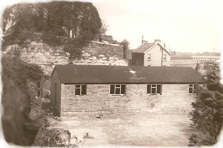
    There was a scout hall built on the site of the station. I've never seen a photo of the station itself.
    I gather that the route of the Summerhill alignment is CIE's to this day, at least is was at time of writing of Cork City Stations by C.Creedon.


  • Advertisement
  • Closed Accounts Posts: 17,733 ✭✭✭✭corktina


    I imagine you have seen the remains of the Cork City Railway whilst looking about...quite easy to trace and the other side of the river, not only are there two remaining narrow guage sattions in addition to the standard gsuage ones remains but you can clearly see where the sidings for the quays used to run from the Yard between the buildings. A very interesting area for the enthusiast.

    I recently realised that there is a fragmnet (I beleive) of the Capwell branch at the traffis lights where the slip road comes off the South Link at Turners Cross...a stone wall cheifly, must get a photo


  • Registered Users, Registered Users 2 Posts: 83 ✭✭sheff_


    Yes, the old Penrose Qy station. The only bits of that left are part of what was the office block near the building formerly used by Guinness and a partly derelict workshop that's in the car park between it and the tunnel.

    The original limestone building is still there surrounding by the old warehouses. Pop these co-ordinates into Google Maps and you'll be landed on the roof. 51.900571, -8.460013


  • Registered Users, Registered Users 2 Posts: 83 ✭✭sheff_


    For an even better view check out the bird's eye view on Bing Maps.


  • Registered Users, Registered Users 2 Posts: 78,580 ✭✭✭✭Victor


    There was a scout hall built on the site of the station. I've never seen a photo of the station itself.
    I gather that the route of the Summerhill alignment is CIE's to this day, at least is was at time of writing of Cork City Stations by C.Creedon.
    I understand the section near the tunnel entrance was sold during the boom.

    I imagine any station buildings may have been primitive.


  • Registered Users, Registered Users 2 Posts: 1,429 ✭✭✭Cedrus


    corktina wrote: »
    you should also be aware that the line from the tunnel used to go straight on to the quays where the original station was located before Glanmire Rd/Kent was built to combine the two lines.

    Before the tunnel was built, the original Cork Station was out in Blackpool, you can still see it from the second level carpark above Atlantic Homecare.

    A small speil about the Summerhill Station and Railway here.


  • Moderators, Music Moderators Posts: 6,525 Mod ✭✭✭✭dregin


    This image of the building is hidden on that page.

    The_Hut_1930.jpg

    *snip*


  • Registered Users, Registered Users 2 Posts: 16,817 ✭✭✭✭whisky_galore


    Victor wrote: »
    I understand the section near the tunnel entrance was sold during the boom.

    I imagine any station buildings may have been primitive.

    It was for sale, don't think there were any takers.


  • Registered Users, Registered Users 2 Posts: 16,817 ✭✭✭✭whisky_galore


    dregin wrote: »
    This image of the building is hidden on that page.

    The_Hut_1930.jpg

    *snip*

    That looks more like the scout hall that was built on the site than the original railway building.


  • Closed Accounts Posts: 1,492 ✭✭✭KCAccidental


    that is the scout hall. I used to be a cub scout at that particular hall.


  • Registered Users, Registered Users 2 Posts: 5,346 ✭✭✭dowlingm


    Being from north Cork and growing up pre-JLTunnel I saw a lot of that stretch of road and being pre-Google Maps/online GIS I figured it was old track but never knew the extent or history until relatively recently.

    One of my favourite youthful "crayon" imaginings was to swap the positions of the road and rail west of the skew bridge (and eliminating the need for same) with the rail line essentially getting a straight shot into Kent, crossing Water Street back before the wood yard went into the bit of land adjacent which (with all due respect to those in the terrace on the south side of the Lower Glanmire) wasn't the best area in Cork at the time. Would have needed some reclamation/seawall to run the line on east (oops, west) of Tivoli to allow the road to be shifted/expanded to 4 lanes (with CPO and demolition of the aforementioned properties) but it would likely have chopped serious time and numbers of accidents out of both rail and road movements of the era. Given the tailbacks one had plenty of time to sit and consider the matter!


  • Advertisement
  • Registered Users, Registered Users 2 Posts: 40,698 ✭✭✭✭Itssoeasy


    There was a scout hall built on the site of the station. I've never seen a photo of the station itself.
    I gather that the route of the Summerhill alignment is CIE's to this day, at least is was at time of writing of Cork City Stations by C.Creedon.

    Well there is a playground on part of it now and other things on it.


Advertisement