Advertisement
If you have a new account but are having problems posting or verifying your account, please email us on hello@boards.ie for help. Thanks :)
Hello all! Please ensure that you are posting a new thread or question in the appropriate forum. The Feedback forum is overwhelmed with questions that are having to be moved elsewhere. If you need help to verify your account contact hello@boards.ie
Hi there,
There is an issue with role permissions that is being worked on at the moment.
If you are having trouble with access or permissions on regional forums please post here to get access: https://www.boards.ie/discussion/2058365403/you-do-not-have-permission-for-that#latest

Loughinsholin barony

Comments

  • Registered Users, Registered Users 2 Posts: 4,798 ✭✭✭goose2005


    I was hoping someone with a good knowledge of irish historical borders could clear this up for me.

    http://en.wikipedia.org/wiki/Loughinsholin

    In this link it says that the area was part of the Ulaidh over-kingdom,

    This image then shows that the area was in the Northern Ui Neill

    http://upload.wikimedia.org/wikipedia/commons/thumb/e/e9/Www.wesleyjohnston.com-users-ireland-maps-historical-map1014.gif/250px-Www.wesleyjohnston.com-users-ireland-maps-historical-map1014.gif

    The first link says that the area then became part of Airgialla but then when you view a map of Airgialla it clearly doesn't include it.

    http://en.wikipedia.org/wiki/File:Ireland900.png

    I am very confused with the history of my local area as it was appently part of the Great O'Neill territory 'Tir Eoghain' whereas other maps show that the Clandeboye O'Neill's ruled it.

    Book recommendations are also welcome.

    The map of Airgialla you have is from AD 900. The borders change a lot. Loughinsholin was Uí Thuirtri and was part of Oriel/Airgialla under the three Collas

    oirgiall.gif


  • Registered Users, Registered Users 2 Posts: 3,284 ✭✭✭dubhthach


    I was hoping someone with a good knowledge of irish historical borders could clear this up for me.

    http://en.wikipedia.org/wiki/Loughinsholin

    In this link it says that the area was part of the Ulaidh over-kingdom,

    This image then shows that the area was in the Northern Ui Neill

    http://upload.wikimedia.org/wikipedia/commons/thumb/e/e9/Www.wesleyjohnston.com-users-ireland-maps-historical-map1014.gif/250px-Www.wesleyjohnston.com-users-ireland-maps-historical-map1014.gif

    The first link says that the area then became part of Airgialla but then when you view a map of Airgialla it clearly doesn't include it.

    http://en.wikipedia.org/wiki/File:Ireland900.png

    I am very confused with the history of my local area as it was appently part of the Great O'Neill territory 'Tir Eoghain' whereas other maps show that the Clandeboye O'Neill's ruled it.

    Book recommendations are also welcome.

    Clandeboye = Clann Aodha Buí (Buidhe = prereform spelling) == "Children of Aodh Buí"

    The descendants of "Aodh Buidhe Ua Néill" (Aodh Buí Ó Néill) who died in 1283. Basically what you are seeing with the Clandeboy's is a "marcher" lordship eating into the former territory of the "Earl of Ulster". This Earldom had been created by the conquest of the Ulaidh by John De Courcy in 1177.

    Due to internal conflict within the wider Ó Néill family they ended up with seperate lordship. Though they did contest the title of "Ó Néill Mór" a number of times.

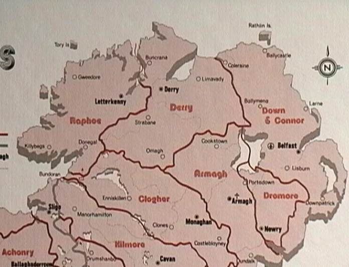
    The diocese of Derry is reflective of Cinéal nEoghain territory during the 12th century. Likewise Raphoe basically maps onto territory of the Uí Néill relatives Cinéal Chonaill
    R-Map.bmp

    Airgialla -> Airghialla -> Oirghialla -> Oirialla (Thence Oriel/Uriel). The territory of Oirialla could be regarded as tributary peoples to the Uí Néill in the period after 400, though over time the "Uí Néill" in the form of the Cineal nEoghain expanded southwards into modern co. Tyrone taking territory. The current county borders are reflective of the status quo in the 16th century.


Advertisement