Advertisement
If you have a new account but are having problems posting or verifying your account, please email us on hello@boards.ie for help. Thanks :)
Hello all! Please ensure that you are posting a new thread or question in the appropriate forum. The Feedback forum is overwhelmed with questions that are having to be moved elsewhere. If you need help to verify your account contact hello@boards.ie
Hi there,
There is an issue with role permissions that is being worked on at the moment.
If you are having trouble with access or permissions on regional forums please post here to get access: https://www.boards.ie/discussion/2058365403/you-do-not-have-permission-for-that#latest

Alaska historic storm on the way

Comments

  • Registered Users, Registered Users 2 Posts: 5,068 ✭✭✭Iancar29


    Polar Low?


  • Registered Users, Registered Users 2 Posts: 882 ✭✭✭fr wishy washy


    Will it have any effect on our weather in the coming days?


  • Posts: 6,025 ✭✭✭ [Deleted User]


    Ive no idea lads :) But Id love it to blow an aul birra snow this way :)

    http://www.msnbc.msn.com/id/45204152/ns/weather/#.TrmGafT_mU9


  • Closed Accounts Posts: 3,548 ✭✭✭Harps


    Nope, pretty much the other side of the world to us

    Looks like its going to skirt northern Alaska which I assume is nearly totally unpopulated aside from the oil fields, impressive storm though, central pressure as low as 945mB


  • Banned (with Prison Access) Posts: 8,632 ✭✭✭darkman2


    Central pressure sub 945hPa


    gfsnh-0-18.png?12


  • Advertisement
  • Registered Users, Registered Users 2 Posts: 200 ✭✭jimmy.d


  • Registered Users, Registered Users 2 Posts: 1,206 ✭✭✭eskimocat


    I sometimes watch Deadliest Catch, a program about crab fishing in the Bering Sea. The weather and seas in that program are mental at the best of times, I cannot imagine what a mega storm would be like!! Keep safe boys and girls up there!


  • Closed Accounts Posts: 4,279 ✭✭✭Su Campu


    Buoy 46035 recorded highest mean windspeeds of 64 knots. Wave height of 38 ft at the moment.


  • Moderators, Recreation & Hobbies Moderators, Sports Moderators Posts: 15,790 Mod ✭✭✭✭Tabnabs


    Evacuation of some coastal communities has begun

    http://www.adn.com/2011/11/08/2160346/powerful-storm-aims-at-western.html


  • Closed Accounts Posts: 2,667 ✭✭✭WolfeIRE


    885_AlaskaStormNov08.jpg

    Captured by the NOAA-19 satellite's AVHRR sensor, the storming bearing down on Alaska is seen in this infrared imagery on November 8, 2011 at 1400z. The storm is predicted to bring hurricane force winds and surge through the Bering Strait. Coastal flood warnings are in effect for much of western Alaska. Because of Alaska's high latitude, geostationary satellite do not provide adequate coverage. Polar-orbiting satellites like NOAA-19 are required to monitor severe weather in such areas. However, polar-orbiting satellites acquire imagery as swaths as the orbit around the planet. The area outside of the swath is visible in this image.

    #################

    Nome, Alaska is getting hit hard by blizzard conditions and 70 mph winds along with 8 foot coastal storm surge.

    tqy.gif
    Peak storm surge for Nome, AK is expected this evening (brown line on graph)


  • Advertisement
  • Closed Accounts Posts: 2,667 ✭✭✭WolfeIRE


    "Its so windy, the snow is getting pushed through every crack in the outer door", according to the twitter user who posted this pic

    scaled.php?tn=0&server=876&filename=5l49.jpg&xsize=640&ysize=640


  • Registered Users, Registered Users 2 Posts: 5,068 ✭✭✭Iancar29


    http://www.twitvid.com/G2A4I


    Short clip of rood tops starting to come loose..


  • Closed Accounts Posts: 1,186 ✭✭✭Kippure


    http://www.alaskadispatch.com/article/alaska-super-storm-sparks-false-alarm-teller-then-real-evacuation

    I love this Quote "polar low grew into a potential storm of the century" now thats hardcore sh@t. Thats what we want this winter....:eek:


  • Registered Users, Registered Users 2 Posts: 5,068 ✭✭✭Iancar29


    Wales, Alaska (111 miles northwest of Nome) is gusting to 86mph. Highest gust for that location thus far. #AKstorm


  • Closed Accounts Posts: 2,667 ✭✭✭WolfeIRE


    Blizzard conditions Hooper Bay Alaska


  • Registered Users, Registered Users 2 Posts: 7,816 ✭✭✭Calibos


    eskimocat wrote: »
    I sometimes watch Deadliest Catch, a program about crab fishing in the Bering Sea. The weather and seas in that program are mental at the best of times, I cannot imagine what a mega storm would be like!! Keep safe boys and girls up there!

    I think they might all be finished Ophilio fishing already. Quota reduced to 50% of last year apparently


  • Registered Users, Registered Users 2 Posts: 273 ✭✭Weylin


    111108_Alaska-Satellite.grid-6x2.jpg
    NOAA This satellite image shows the storm system moving into western Alaska on Tuesday afternoon.

    msnbc.com staff and news service reports

    updated 11/8/2011 7:01:02 PM ET 2011-11-09T00:01:02 A rapidly intensifying storm was hammering the west coast of Alaska on Tuesday and could become "one of the worst on record" for the region.
    1. Only on msnbc.com
      1. cain-1916897707_v2.htease.jpg
        AP
        Cain maintains: 'I have never acted inappropriately'
      2. 111109_berlusconi.htease.jpg
        AFP - Getty Images
        For Italians, champagne on ice til Berlusconi really leaves
      3. Beijing residents call foul over the air
      4. First Read: Ohio voters reject curbs on public employee unions
      5. Dems rebuff GOP tax proposal as 'insane'
      6. tease-Barnett1.htease.jpg
        Jason Barnett / Special to msnbc
        ID theft victim shares SSN with 50 people
      7. [URL="javascript:ijv.launchVideo('45215197');"]nn_11gle_astroid_111108.htease.jpg [/URL]

        [URL="javascript:ijv.launchVideo('45215197');"]Asteroid misses Earth by 200,000 miles [/URL]
    The storm was traveling at 60 mph, said Andy Brown, lead National Weather Service forecaster in Anchorage. It could reach the beachfront city of Nome by late Tuesday, with winds hitting 85 mph.
    The storm was expected to produce a 10-foot surge, forcing dozens of coastal communities to make emergency preparations. Brown advised Bering Sea mariners and people living in coastal communities from Wales to Unalakleet to "prepare for a really nasty storm."
    "It is very dangerous," Brown said. "Everybody is spreading the word to let them know this is a major storm."
    That included the Coast Guard. "We are prestaging helicopters from Air Station Kodiak to parts of Western Alaska in response to severe weather advisories including hurricane force winds and high seas that are forecast all along the west coast of Alaska," said Capt. Daniel Travers.
    The storm, described by Brown as "big, deep, low," was taking an unusual path through the northern and eastern Bering Sea.
    The storm will likely be "life-threatening ... one of the worst on record," the service said.
    "Essentially the entire west coast of Alaska is going to see blizzard and winter conditions: heavy snow, poor visibility, high winds," NWS forecaster Bob Fischer told alaskadispatch.com.
    Posing an additional threat is the lack of sea ice off northwestern Alaska, Brown said. The last time a storm of a similar magnitude was sent in the same northward direction was 1974, but the sea surface was much more frozen then, he said.
    "History tells that the sea ice helps subdue the storm surge," Brown said "With no sea ice there, we could see the full brunt of that 6- to 9-foot storm surge."
    Arctic sea ice this year reached the second-lowest coverage since satellite records began in 1979, according to the National Snow and Ice Data Center in Boulder, Colo.
    Scientists there on Tuesday were watching the Alaska storm and anticipating its impacts.
    "Forty years ago, a big storm like this would come through and the sea ice would act as sort of a buffer," said Mark Serreze, director of the Snow and Ice Data Center. "The Bering Sea has and always will have these strong storms. What is different now is their potential destructiveness as you lose the sea ice cover."
    'Sideways snow' in Nome
    The windows were boarded up Tuesday morning at the Polar Café, a popular restaurant that faces the ocean in Nome, a town of 3,600. Items stored in the basement had been carried upstairs and were in one of the hotel rooms, said waitress Andrea Surina. Plans were being made to move the propane tanks to a safer spot, she said.
    "It is blowing sideways snow. The water hasn't really come up much yet but it is starting to," Surina said.
    The approaching storm, however, wasn't keeping the regulars away. They were sitting at their usual table, talking about the storm, she said.
    "It is heading right for us," Surina said. "Nobody misses a good storm."
    The wind and waves had started picking up by late morning, said Scott Johnson, 28, a Nome banker, prompting some people to evacuate inland to stay with friends or family in case predictions for a big ocean wave surge prove to be true.
    "The waves are starting to go up against our seawall," he said from his second-story apartment that sits on the ocean.
    Johnson said he loaded a couple of bags into his truck and got gas so he's ready to go.
    "If there are 30-foot waves, A, they might be coming over the sea and B, they might be coming into my apartment," he said.
    Stores are still pretty well stocked, but some businesses closed early.
    "The general view out here is we get storms like this on a fairly regular basis," Johnson said.
    "We kind of shrug it off. But when the National Weather Service is trying to sound an alarm with 30-foot seas and this is a rare storm, take it seriously. I think they're taking it seriously with a grain of salt."
    The last time forecasters saw something similar was in November 1974, when Nome also took the brunt of the storm. That surge measured more than 13 feet, pushing beach driftwood above the level of the previous storm of its type in 1913.

    Winds from the current storm were expected to push large amounts of water into Norton Sound, raising sea levels 10 feet above normal through Wednesday.
    That will cause beach erosion and flooding and may push Norton Bay ice on shore, forecasters said.
    Seas were expected to begin rising along the coastline Tuesday afternoon and gain height rapidly at night before cresting in Nome on Wednesday.
    Less-protected areas
    Smaller coastal towns were also threatened, including Kivalina, whose 400 residents live on a spit of land jutting into the Chukchi Sea. Reduced sea ice levels there in recent years have meant more shoreline erosion from storms.
    A rock wall built recently has not yet been tested by a big storm, but Mayor Thomas Hanifan Jr. told the Fairbanks News-Miner that "I'm fully confident it will hold."
    He added that residents would take shelter at the local school, the highest point in town, should the storm cause a flood surge. "We are making sure anything that is loose is being tied down," he added. "There’s not much we can do."
    The village of Point Hope, which sits on the tip of a peninsula with the Arctic Ocean on one side and the Bering Sea on the other, is 7 to 8 feet above sea level, Mayor Steve Oomittuk said.
    The Inupiat Eskimo village of about 700 people has no sea wall and no evacuation road. If evacuation becomes necessary, everyone will go to the school because it sits on higher ground and is big enough to accommodate everyone, he said.
    Oomittuk was meeting Tuesday afternoon with fire and rescue personnel and others that might be needed when the storm hits. "We are ready," he said.
    The Associated Press and Reuters contributed to this report.


  • Moderators, Technology & Internet Moderators Posts: 17,137 Mod ✭✭✭✭cherryghost


  • Closed Accounts Posts: 4,279 ✭✭✭Su Campu


    We speak of the 850 hPa level usually being around 1,400 - 1,500 metres. Well, at the core of the storm, it was down to just 840 metres! :eek:

    180879.jpg


  • Registered Users, Registered Users 2 Posts: 5,068 ✭✭✭Iancar29


    Woah.. Thats some serious gradient on the eastern edge... is it past the peak yet ye?
    I wonder what the top wind gust was, i seen an 83mph gust posted earlier.


  • Advertisement
  • Registered Users, Registered Users 2 Posts: 14,743 ✭✭✭✭M.T. Cranium


    The storm has passed its peak intensity now and has moved across Russia's far eastern Chuthosk peninsula into the Arctic Ocean southeast of Wrangel Island. I copied these reports from the NWS site, Alaska "public reports" ...

    THE FOLLOWING IS A COMPILATION OF MAXIMUM WIND GUSTS SO FAR:

    GAMBELL: 74 MPH AT 6PM TUE
    SAVOONGA: 76 MPH AT 7PM TUE
    TIN CITY: 85 MPH MIDNIGHT WED
    WALES: 89 MPH 0142 WED MORNING
    TELLER: 71 MPH 6AM WED
    ST MICHAEL: 68 MPH MIDNIGHT WED
    UNALAKLEET: 66 MPH MIDNIGHT WED
    GOLOVIN: 64 MPH MIDNIGHT WED
    NOME: 61 MPH 9PM TUE
    POINT HOPE: 78 MPH 5AM WED
    CAPE LISBURNE: 81 MPH 7AM WED
    SHISHMAREF: 57 MPH 0016 WED MORNING
    KIVALINA: 71 MPH 0323 WED MORNING KOTZEBUE: 74 MPH 6AM WED
    NOORVIK: 67 MPH 0423 WED MORNING

    The local time zone would be 10-11 hours behind GMT. Looks like Wales got the worst of it. Here's the 12z global map from the Canadian met service which shows the storm near its peak intensity.


  • Registered Users, Registered Users 2 Posts: 5,140 ✭✭✭John mac


    some more videos on the US National Weather Service Alaska facebook page.
    here
    YOu dont need to be on facebook to see them. :)


  • Closed Accounts Posts: 2,667 ✭✭✭WolfeIRE


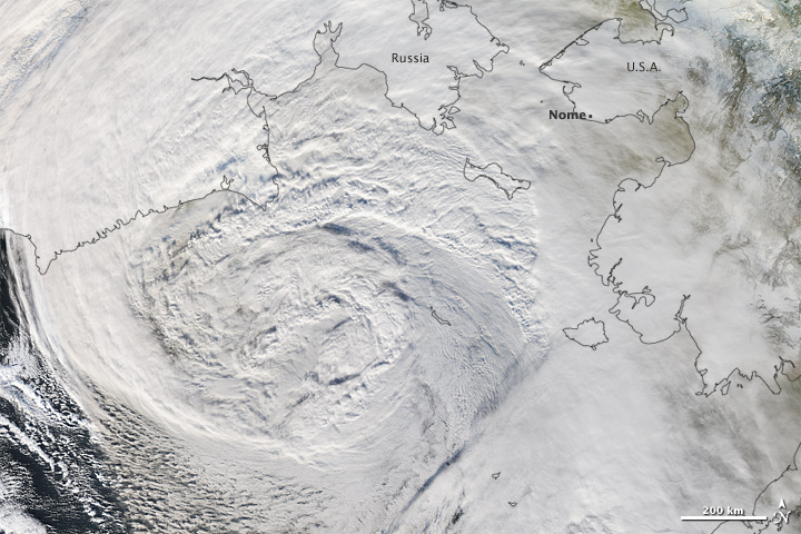
    The Moderate Resolution Imaging Spectroradiometer (MODIS) on NASA’s Aqua satellite took this image at 2:45 p.m. local time on Wednesday while the storm was still over the Bering Sea and moving northeast toward Alaska.

    Even though the storm resembled a hurricane, its core was full of cold air, not hot air. The storm formed when a stream of warm, moist air from the Pacific Ocean clashed with cold Siberian air and moved over the Bering Sea. Strong winds blowing over a long distance allowed a storm surge to build.


    It is the strongest storm to hit northwest Alaska since 1974

    bering_amo_2011312.jpg


Advertisement