Advertisement
If you have a new account but are having problems posting or verifying your account, please email us on hello@boards.ie for help. Thanks :)
Hello all! Please ensure that you are posting a new thread or question in the appropriate forum. The Feedback forum is overwhelmed with questions that are having to be moved elsewhere. If you need help to verify your account contact hello@boards.ie
Hi there,
There is an issue with role permissions that is being worked on at the moment.
If you are having trouble with access or permissions on regional forums please post here to get access: https://www.boards.ie/discussion/2058365403/you-do-not-have-permission-for-that#latest

colorado earthquake !!!

  • 23-08-2011 8:49pm
    #1
    Registered Users, Registered Users 2 Posts: 108 ✭✭


    2011-08-22_181147.jpg

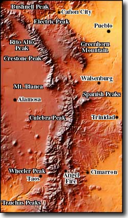
    sangresmapA.jpgAugust 23, 2011 COLORADO – Southern Colorado was rattled by a magnitude 4.6 earthquake Monday evening near Trinidad. That quake was overshadowed by a much stronger 5.3 magnitude earthquake which struck near the same region. A string of aftershocks followed. The same area had been struck by a gentler temblor earlier in the morning. According to the US Geological Survey, the 4.6 quake occurred at 5:30pm and was centered 16 miles west southwest of Trinidad or 20 miles west northwest of Raton, New Mexico. The quake occurred at a relatively shallow depth of 5.0 miles. Initial reports show the quake was felt in Trinidad and as far north as La Veta and Aguilar. To the south in New Mexico, Raton felt the shaking as well as Springer and Questa. This morning, a magnitude 2.9 quake struck the same area at 7:52am. This also follows a magnitude 2.8 temblor in March. Other quakes up to magnitude 4.1 have been recorded in January 2010 as well as a series of quakes in the area in August 2009. The earthquake’s epicenter was 299 km (185 miles) S of DENVER, Colorado. –The ExaminerSeismicity activity in the Sangre de Cristos Mountains: The Sangre de Cristos are fault block mountains with major fault lines running along both the east and west sides of the mountains. In places, there are also fault lines cutting right through the mountain chain. The mountains were pushed up about 27 million years ago, pretty much as one big chunk of rock. On the west side is the San Luis Valley with the Rio Grande Rift Zone running down the middle. On the southeast side is the Raton Basin with a quiet but still active volcano field. On the northeast side are the Wet Mountains and the Front Range, areas of pre-Cambrian rock raised up during the Colorado Orogeny some 1.7 billion years ago. The Blanca Massif is also pre-Cambrian rock while the main body of the Sangres themselves is composed of Permian-Pennsylvanian rock and a mix of igneous intrusions, conglomerates and shale that is only about 250 million years old. -SangresColorado experiences largest quake in more than 40 years: A moderate 5.3-magnitude earthquake that rattled southern Colorado early Tuesday morning was the largest to hit the state in more than 40 years, the U.S. Geological Survey said. The quake’s epicenter was seven miles southwest of Cokedale, and 180 miles south of Denver. There were no immediate reports of casualties. A dispatcher at the sheriff’s office in Las Animas County, which includes Cokedale, said the quake lasted almost 30 seconds. The office received reports of rocks falling on a highway and of some structure damage. It was the largest in a series of earthquakes that struck the area. As of 5 a.m. local time (7 a.m. ET), the USGS reported seven quakes centered just south of Cokedale since midnight. Amy Vaughan of the USGS said the 5.3 magnitude ties that of an earthquake Colorado suffered on August 9, 1967. In 1973, the USGS originally reported a quake with a magnitude of 5.7, but it turned out that was caused by an explosion, Vaughan said. -CNN


Advertisement