Advertisement
If you have a new account but are having problems posting or verifying your account, please email us on hello@boards.ie for help. Thanks :)
Hello all! Please ensure that you are posting a new thread or question in the appropriate forum. The Feedback forum is overwhelmed with questions that are having to be moved elsewhere. If you need help to verify your account contact hello@boards.ie
Hi there,
There is an issue with role permissions that is being worked on at the moment.
If you are having trouble with access or permissions on regional forums please post here to get access: https://www.boards.ie/discussion/2058365403/you-do-not-have-permission-for-that#latest

Convert Garmin GPS Co-Ords to Irish National Grid

  • 18-10-2010 5:07pm
    #1
    Registered Users, Registered Users 2 Posts: 6,259 ✭✭✭


    Hi, just wondering if anyone has a method to convert (batch convert if possible) Garmin GPS Coordinates (Northing & Westing, 52° 18' 12.0" 008° 16' 06.3") to Irish National Grid Co-ordinates?

    Cheers.


Comments

  • Closed Accounts Posts: 85 ✭✭YoureATowel


    Hi, just wondering if anyone has a method to convert (batch convert if possible) Garmin GPS Coordinates (Northing & Westing, 52° 18' 12.0" 008° 16' 06.3") to Irish National Grid Co-ordinates?

    Cheers.

    They're WGS-84 geographic coordinates, ie latitude and longitude in degrees, minutes, seconds.

    What is the format of your input file? Can you post a screenshot? Do you still have access to ArcGIS?


  • Registered Users, Registered Users 2 Posts: 6,259 ✭✭✭Rowley Birkin QC


    They're WGS-84 geographic coordinates, ie latitude and longitude in degrees, minutes, seconds.

    What is the format of your input file? Can you post a screenshot? Do you still have access to ArcGIS?

    I have the data in Excel format. Yes I still have access to ArcGIS.

    I've uploaded the file here. I've found a way to convert them one by one but if there was a way to do them in a batch job it would speed things up.

    Thanks again Youreatowel.

    EDIT:Just thought I should add that I will need to send the ING co-ords on to a project team in an Excel file.


  • Closed Accounts Posts: 85 ✭✭YoureATowel


    I have the data in Excel format. Yes I still have access to ArcGIS.

    I've uploaded the file here. I've found a way to convert them one by one but if there was a way to do them in a batch job it would speed things up.

    Thanks again Youreatowel.

    EDIT:Just thought I should add that I will need to send the ING co-ords on to a project team in an Excel file.

    Is that the original file? I mean does it have the LAT, LONG columns by default or did you have to add them? Is that what you mean by one-by-one?

    If they are in the original file then you're half way there, as the coords are in decimal degree format. Note that the longitude of Station 13 is missing a decimal point.

    1. In ArcMap click on the Add Data button.

    2. Navigate to the Points Completed.xls file and double click on it. Select Sheet1$ and click add. The Excel sheet is added to the TOC.

    3. Right click and select Display XY Data. For X Field select LONG, for Y Field select LAT.

    4. Under Coordinate System of Input Coordinates click on Edit. Next click on Select. Go to Geographic Coordinate Systems-World-WGS 1984.prj and press Add. The XY Events are added to the map.

    5. In ArcToolbox open Data Management Tools-Projections and Transformations-Feature-Project. For Input Dataset select Sheet1$ Events, for Output Dataset select an appropriate filename and location. For Output Coordinate System go to Projected Coordinate Systems-National Grids-Irish National Grid.prj, finally select TM65_To_WGS_1984 for Geographic Transformation.

    6. Click OK and the transformation is carried out.

    7. Start a new map and add the newly created shape file and open its attribute table. Under Options select Add Field. For Name input X_ING, for Type select Double. Repeat for Y_ING.

    8. Right click on X_ING, select Calculate Geometry. For Property use X Coordinate of Point. Repeat for Y_ING. The ING Eastings and Northings are now added to the table.

    9. Under Options, select Export and output the file to a dbf. This can be opened and saved in Excel.


  • Registered Users, Registered Users 2 Posts: 1,021 ✭✭✭Coles


    FieldenMaps - Very handy grid location converter for occasional use.


  • Registered Users, Registered Users 2 Posts: 6,259 ✭✭✭Rowley Birkin QC


    Is that the original file? I mean does it have the LAT, LONG columns by default or did you have to add them? Is that what you mean by one-by-one?

    Wow, thanks. That made life so much easier. I really feel like I need to start paying you a wage!! :)

    When I said one by one I was typing the DMS format into this tool http://franson.com/coordtrans/ and getting ING coordinates back, one at a time. I had previously converted the DMS coordinates to Decimal Degrees using a similar online tool. I had added the LAT, LONG columns at that stage.

    To save time in the future is it possible to directly use the DMS coordinates direct from the Satnav and project them following the same type of procedure you outlined about??

    Thanks again for all the help.


  • Advertisement
  • Closed Accounts Posts: 85 ✭✭YoureATowel


    Wow, thanks. That made life so much easier. I really feel like I need to start paying you a wage!! :)

    When I said one by one I was typing the DMS format into this tool http://franson.com/coordtrans/ and getting ING coordinates back, one at a time. I had previously converted the DMS coordinates to Decimal Degrees using a similar online tool. I had added the LAT, LONG columns at that stage.

    To save time in the future is it possible to directly use the DMS coordinates direct from the Satnav and project them following the same type of procedure you outlined about??

    Thanks again for all the help.

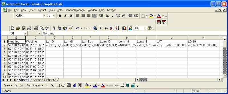
    If I was faced with this problem I would write a quick geoprocessing script that would parse out the individual degree, minute & second components and convert them to decimal degrees. In fact I would automate the entire process outlined above.

    However, if you don't have any programming you can easily use Excel to parse out the components and the do the conversion to decimal degrees.

    I outlined a similar process in the GIS Help thread. The following image shows an example of the formulas that could be used here.

    Excel.jpg

    Once the first line is filled in you just copy down to fill all the required cells.


  • Registered Users, Registered Users 2 Posts: 610 ✭✭✭muckish


    Hi, just wondering if anyone has a method to convert (batch convert if possible) Garmin GPS Coordinates (Northing & Westing, 52° 18' 12.0" 008° 16' 06.3") to Irish National Grid Co-ordinates?

    Cheers.

    Seems you got sorted but for future use change the co-ordinate projection on your GPS to either Irish National Grid or WGS84decimal degrees. Save all the problem of trying to parse out characters etc


  • Registered Users, Registered Users 2 Posts: 6,259 ✭✭✭Rowley Birkin QC


    muckish wrote: »
    Seems you got sorted but for future use change the co-ordinate projection on your GPS to either Irish National Grid or WGS84decimal degrees. Save all the problem of trying to parse out characters etc

    Do you know how to do this on a Garmin Nuvi system?


  • Registered Users, Registered Users 2 Posts: 610 ✭✭✭muckish


    So it's a SatNav? I thought it was a handheld gps. Satnavs have very limited coordinte control, if any. I would try the settings to see if there's an option to change the format of the WGS84. The only other option is in the Garmin mapping software. There may be an option there. Unfortunately I don't have the software on this laptop so I can't test it for you, (untill Monday).
    Are you trying to get the coordinates into a GIS system? Whish GIS if you are?


  • Registered Users, Registered Users 2 Posts: 6,259 ✭✭✭Rowley Birkin QC


    muckish wrote: »
    So it's a SatNav? I thought it was a handheld gps. Satnavs have very limited coordinte control, if any. I would try the settings to see if there's an option to change the format of the WGS84. The only other option is in the Garmin mapping software. There may be an option there. Unfortunately I don't have the software on this laptop so I can't test it for you, (untill Monday).
    Are you trying to get the coordinates into a GIS system? Whish GIS if you are?

    No, I got it all sorted. It was for a university project so I just sat down one night and did them one by one.

    Using ArcMap.


  • Advertisement
  • Registered Users, Registered Users 2 Posts: 610 ✭✭✭muckish


    If you have the Garmin MapSource software and you connect the satnav to your pc to download the waypoints routes etc, you can display the info in MapSource in Irish National Grid. In mapsource goto edit>Preferences> Click on the Position tab. Change the Grid drop down list to Irish National Grid. The ING coordinates will display in the bottom of the mapsource window.

    Be aware that Garmin still seem to use the old Alpha grid system + 5 digit ING coordinates. So for example for ING coordinates for grid B in Donegal you would add 100000 to the easting value and 400000 to the northing value to get the full 6 digit coordinate.


Advertisement