Advertisement
If you have a new account but are having problems posting or verifying your account, please email us on hello@boards.ie for help. Thanks :)
Hello all! Please ensure that you are posting a new thread or question in the appropriate forum. The Feedback forum is overwhelmed with questions that are having to be moved elsewhere. If you need help to verify your account contact hello@boards.ie

An answer to global warming?

Options
  • 14-12-2009 9:22am
    #1
    Closed Accounts Posts: 4,124 ✭✭✭


    Through discussions on another science related forum, an idea has come up which is both unique and unusual, which might give us a bit of breathing space to sort out industrial pollution. It won't solve the problem, but should take the pressure off for a bit, allowing developing and developed nations to clean up their act.

    The Eyre basin in Australia is a huge salt desert in which used to be an inland sea, and is about 15m below sea level, so the idea was to dig two canals to the ocean and boom, you have an inland sea again and Australia stops being a desert. Purely back of the envelope calculations here:

    The Eyre basin is some 171000 cubic kilometers, assuming an average of 15m below sea level.

    The entire ocean has some 1347000000 cubic kilometers.

    This makes the Eyre Basin approximately 0.000126948775 of the entire oceans in the world, and since the average depth of the ocean is about 3,796 meters, that comes to a roughly 48cm drop, which according to wikipedia should offset the effects of global warming for a century or so.
    Current sea level rise has occurred at a mean rate of 1.8 mm per year for the past century,[1][2] and more recently at rates estimated near 2.8 ± 0.4[3] to 3.1 ± 0.7[4] mm per year (1993-2003). Current sea level rise is due significantly to global warming,[5] which will increase sea level over the coming century and longer periods.[6][7] Increasing temperatures result in sea level rise by the thermal expansion of water and through the addition of water to the oceans from the melting of continental ice sheets. Thermal expansion, which is well-quantified, is currently the primary contributor to sea level rise and is expected to be the primary contributor over the course of the next century. Glacial contributions to sea-level rise are less important,[8] and are more difficult to predict and quantify.[8] Values for predicted sea level rise over the course of the next century typically range from 90 to 880 mm, with a central value of 480 mm.

    Apparently its going to happen one way or the other in a couple of centuries since a sea level rise of about 50cm should start the ball rolling with the water draining from Spencer's Gulf to "Lake" Giles (really just a large patch of damp salt) then onto the other lakes.

    You could pay for the entire operation by putting a percentage of the sale of new beachfront property towards it, as well as having enough left over to cover new infrastructure, resorts and facilities. The ecological impact could be dealt with by relocating niche indigenous species to another location, or to specially prepared reserves, while as far as I'm aware the removal of such a large dustbowl should have positive effects on the Australian environment, allowing much of it to return to verdant jungle.

    The only question is, would the change of that much seawater/addition of a large body of water have unexpected side effects for the global climate.


«1

Comments

  • Closed Accounts Posts: 462 ✭✭Btwndeyes


    hmmm this is an interesting idea, although i think many goverments would just do it so they could reduce spending on environmental policies to save themselves money, and we'd end up in the same predicament 50 years down the line


  • Registered Users Posts: 15,443 ✭✭✭✭bonkey


    Amhran Nua wrote: »
    The only question is, would the change of that much seawater/addition of a large body of water have unexpected side effects for the global climate.
    I would jump to a completely non-scientific, gut-feeling-based "yes" on that.

    There was an article last week (New SCientist, IIRC, referenced from Slashdot) about how the Med may have filled (some 5 million years ago) in a matter of weeks due to the collapse of what was then a barrier at Gibraltar...and how this would have had an impact on global climate.

    Interesting idea, though.


  • Registered Users Posts: 22,363 ✭✭✭✭Akrasia


    Sounds cool. Probably wouldn't be very good for the lesser spotted scorpion, but if it could promote more biodiversity along the shore then it might be a reasonable tradeoff.

    Probably would affect ocean currents and rainfall patterns, but it's hard to imagine that it would make Australia's climate any worse...


  • Closed Accounts Posts: 341 ✭✭auerillo


    Amhran Nua wrote: »
    Through discussions on another science related forum, an idea has come up which is both unique and unusual, which might give us a bit of breathing space to sort out industrial pollution. It won't solve the problem, but should take the pressure off for a bit, allowing developing and developed nations to clean up their act.

    The Eyre basin in Australia is a huge salt desert in which used to be an inland sea, and is about 15m below sea level, so the idea was to dig two canals to the ocean and boom, you have an inland sea again and Australia stops being a desert. Purely back of the envelope calculations here:

    The Eyre basin is some 171000 cubic kilometers, assuming an average of 15m below sea level.

    The entire ocean has some 1347000000 cubic kilometers.

    This makes the Eyre Basin approximately 0.000126948775 of the entire oceans in the world, and since the average depth of the ocean is about 3,796 meters, that comes to a roughly 48cm drop, which according to wikipedia should offset the effects of global warming for a century or so.


    Apparently its going to happen one way or the other in a couple of centuries since a sea level rise of about 50cm should start the ball rolling with the water draining from Spencer's Gulf to "Lake" Giles (really just a large patch of damp salt) then onto the other lakes.

    You could pay for the entire operation by putting a percentage of the sale of new beachfront property towards it, as well as having enough left over to cover new infrastructure, resorts and facilities. The ecological impact could be dealt with by relocating niche indigenous species to another location, or to specially prepared reserves, while as far as I'm aware the removal of such a large dustbowl should have positive effects on the Australian environment, allowing much of it to return to verdant jungle.

    The only question is, would the change of that much seawater/addition of a large body of water have unexpected side effects for the global climate.

    I suppose an interesting question to ponder is when did this basin dry up? And was it due to sea levels receeding, or what was teh reason it dried up?

    I am aware of many salt pans in Africa, too, and wonder did they dry up for the same reason, assuming they were also under water some time ago.


  • Posts: 0 [Deleted User]


    auerillo wrote: »
    I suppose an interesting question to ponder is when did this basin dry up? And was it due to sea levels receeding, or what was teh reason it dried up?

    I am aware of many salt pans in Africa, too, and wonder did they dry up for the same reason, assuming they were also under water some time ago.

    Lake Eyre in Australia is a seasonal lake. With the hot and dry seasons in Australia many lakes and rivers are seasonal! I assume the same occurs in Africa. Oh and the salt and minerals left in the lake is from all the evaporated water !


  • Advertisement
  • Registered Users Posts: 22,363 ✭✭✭✭Akrasia


    Lake Eyre in Australia is a seasonal lake. With the hot and dry seasons in Australia many lakes and rivers are seasonal! I assume the same occurs in Africa. Oh and the salt and minerals left in the lake is from all the evaporated water !

    yeah, basically if there isn't enough water flowing in to replace the water that is evaporated then the lake dries up.

    Usually the salt planes can be explained by continental drift, what was once part of the ocean gets cut off by the movements of the various plates and then without a source of new water, over a few hundred years, the sun simply evaporates the sea.

    The Mediterranean sea is going to get cut off from the ocean in the next few thousand years when the strait of gibralter is pushed closed and eventually, it will dry up (assuming sea levels don't rise too much and flood it from somewhere else)


  • Closed Accounts Posts: 4,124 ✭✭✭Amhran Nua


    auerillo wrote: »
    I suppose an interesting question to ponder is when did this basin dry up? And was it due to sea levels receeding, or what was teh reason it dried up?
    As I understand it the start of the ice ages was when the basin dried up, it stands at about one sixth of Australia now. From wikipedia:
    The deserts that have formed in the basin, including Sturt's Stony Desert, Tirari Desert and the Strzelecki Desert, are most probably the southern hemisphere's largest source of airborne dust. The basin is also one of the largest, least-developed arid zone basins with high degrees of variability anywhere. Grazing is the major land use, occupying 82% of the total land within the basin. The grazing is mostly low density due to harsh and variable climatic conditions.

    The basin began as a sinking landmass mostly covered by forest and contained many more lakes than now. The climate has changed from wet to arid over the last 60 million years. Most of the rivers in the Lake Eyre basin are now slow flowing, flat and completely dry for lengthy periods. They all flow towards the lowest point in the basin, 16 metres below sea level, at Lake Eyre.

    ...

    The basin began to form in the early Tertiary (about 60 million years ago) when south-eastern South Australia started to sink and rivers began to deposit sediment into the large, shallow basin. The basin is still gradually sinking, and still gradually accumulating sediment.[citation needed] For many millions of years, the Lake Eyre Basin was well supplied with water and largely forested. About 20 million years ago, large shallow lakes formed, covering much of the area for about 10 million years. From that time on, as Australia drifted further north and the climate became gradually more arid, the lakes and floodplains started to dry. Only in the last 2.6 million years did the onset of the ice ages bring about the present climatic regime and the consequent fairly rapid desertification of the area.

    And a possible weak link in the plan, although they could just build oil platforms I guess:
    Significant minerals deposits such as oil and natural gas, including Australia's most significant onshore petroleum reserves, are found within the basin. The mining and petroleum industries account for the greatest economic activity in the Lake Eyre Basin. Opals, coal, phosphate, gypsum and uranium are also mined from the basin.


  • Closed Accounts Posts: 3 finchie


    Although that may seem like a good idea looking at it from where we're standing.

    I'm sure if you got someone in the know in Australia they would give you a far more nuanced account of the possible problems - after all you are proposing to flood a massive area.

    There are likely to be enormous and unforeseen issues with a geo-engineering project of this size.

    For example it could seriously destabalise land in the surrounding area and it's worth remembering that the weight of water from China's latest dam was blamed for the enormous earthquake that rocked the region.


  • Registered Users Posts: 22,363 ✭✭✭✭Akrasia


    finchie wrote: »
    Although that may seem like a good idea looking at it from where we're standing.

    I'm sure if you got someone in the know in Australia they would give you a far more nuanced account of the possible problems - after all you are proposing to flood a massive area.

    There are likely to be enormous and unforeseen issues with a geo-engineering project of this size.

    For example it could seriously destabalise land in the surrounding area and it's worth remembering that the weight of water from China's latest dam was blamed for the enormous earthquake that rocked the region.
    Yeah, but they're only Austrialians


  • Closed Accounts Posts: 191 ✭✭Mozart1986


    How about Death Valley as well. Great stuff:D I think I'll by property there now. I'd love a sea view.


  • Advertisement
  • Closed Accounts Posts: 3 finchie


    or the midlands? - although it seems that climate change doesn't need any help doing that.


  • Closed Accounts Posts: 462 ✭✭Btwndeyes


    Im currently studying evironmental science and i brought this up wiyh a few of my class and another advantage was thought of. Many will kno with the polar caps melting the salt water ratio has tipped away from the salt side and this is affecting the warm water currents moving around our oceans. Many of these salt plains contains up to 80% salt in their soils and so if these plains were reflooded there would be a natural rebalancing of this salt water equilibrium.:cool:


  • Closed Accounts Posts: 191 ✭✭Mozart1986


    Cool! We built the Suez and Panama canals, this project shouldn't be an issue. This would also allow people to regulate the effects upon the environment, around, rather than allowing the sea levels to dictate the terms of our infrastructural/environmental adjustments. And think about the power that could be produced by such a project. You could dam it and produce power at every low tide:) Sounds interesting.


  • Registered Users Posts: 2,921 ✭✭✭2 stroke


    Wow! How interesting. Here in Ireland we could flood Cork.


  • Closed Accounts Posts: 4,124 ✭✭✭Amhran Nua


    Mozart1986 wrote: »
    You could dam it and produce power at every low tide:) Sounds interesting.
    I'd imagine something on that scale could keep Australia in nice clean hydro power for the next few hundred years alright. The opportunity for some exciting science and engineering projects would be unrivalled - you could test out a variety of undersea habitats, biospheres, and hydroponics farms by building them on the cheap when the area is dry, set up fish farm infrastructure in advance of the flood, crash test various building types and materials when they get hit by a 15m high wall of water, build artificial islands in whatever shape suits you and sell them to investors, again extremely cheap since you would be moving around desert, an ultimate surfing event (:D) or shoot a disaster movie.


  • Banned (with Prison Access) Posts: 6,869 ✭✭✭Mahatma coat


    that is a very good idea, I've been discussin similar witha few mates over here, I had the idae that instead of diggin channels we could fil it with Freshwater from Antarctica via Zeplins.

    I have an Idea that I'm fleshin out at the moment but It may be possible to build a Zepin like thingy a\nd then get Water Vapour attracted to it via Some kinda static makin it possibe to transport fresh watrer from the Icecaps BEFORE they melt.

    the only real issue is that most ogf the Big Open Cast mines are gonna get shafted.


  • Closed Accounts Posts: 462 ✭✭Btwndeyes


    that is a very good idea, I've been discussin similar witha few mates over here, I had the idae that instead of diggin channels we could fil it with Freshwater from Antarctica via Zeplins.

    I have an Idea that I'm fleshin out at the moment but It may be possible to build a Zepin like thingy a\nd then get Water Vapour attracted to it via Some kinda static makin it possibe to transport fresh watrer from the Icecaps BEFORE they melt.

    the only real issue is that most ogf the Big Open Cast mines are gonna get shafted.

    LOl one thing static on a zeplin?? remember the hindenburg disaster???


  • Banned (with Prison Access) Posts: 6,869 ✭✭✭Mahatma coat


    see thats why I was thinkin of usin HELIUM, should have made that clearer :o

    I'm thinkin about this Cloud Seedin technology that they have on the go at the moment coupled with natural weather paterns at high atitudes, it may not be as far fetched as most people would initially presume


  • Registered Users Posts: 22,363 ✭✭✭✭Akrasia


    see thats why I was thinkin of usin HELIUM, should have made that clearer :o

    I'm thinkin about this Cloud Seedin technology that they have on the go at the moment coupled with natural weather paterns at high atitudes, it may not be as far fetched as most people would initially presume


    Why that might just be crazy enough to work!!!

    No wait, it's just crazy :)


  • Closed Accounts Posts: 4,124 ✭✭✭Amhran Nua


    Akrasia wrote: »
    No wait, it's just crazy :)
    Ah but who among us can honestly say he hasn't dreamt of using zeppelins to ferry a cube of freshwater fifty five kilometers on a side into the Australian outback? Let he who is without helium cast the first stone!


  • Advertisement
  • Closed Accounts Posts: 191 ✭✭Mozart1986


    Amhran Nua wrote: »
    ? Let he who is without helium cast the first stone!
    I wouldn't cast stones at a zeppelin:eek:. One little prick and "Oh the calamity!":D.


  • Registered Users Posts: 22,363 ✭✭✭✭Akrasia


    Amhran Nua wrote: »
    Ah but who among us can honestly say he hasn't dreamt of using zeppelins to ferry a cube of freshwater fifty five kilometers on a side into the Australian outback? Let he who is without helium cast the first stone!

    well when you put it like that, you've convinced me.


  • Registered Users Posts: 233 ✭✭maniac101


    Amhran Nua wrote: »
    The Eyre basin in Australia is a huge salt desert in which used to be an inland sea, and is about 15m below sea level, so the idea was to dig two canals to the ocean and boom, you have an inland sea again and Australia stops being a desert. Purely back of the envelope calculations here:

    The Eyre basin is some 171000 cubic kilometers, assuming an average of 15m below sea level.

    The entire ocean has some 1347000000 cubic kilometers.

    This makes the Eyre Basin approximately 0.000126948775 of the entire oceans in the world, and since the average depth of the ocean is about 3,796 meters, that comes to a roughly 48cm drop, which according to wikipedia should offset the effects of global warming for a century or so.
    These figures are all wrong I'm afraid. The Eyre basin is 15m below sea level at its deepest. This is at the lowest point of the lake part only. This site shows a total volume of only 30km^^3, not the 171000km^^3 you suggest. The much larger Eyre basin itself is above sea level, with elevations in excess of 1km above sea level in places. You can't fill it with water. If you could fill the small bit below sea level (which sometimes floods anyway) with sea water it would have no effect on global sea levels whatsoever.

    By the way, if you could address the issue of sea levels in isolation it would do nothing to alleviate the other effects of global warming; changing land use and potential food shortages, drought and starvation, extreme weather events such as floods and hurricanes and associated damage to economies, etc.


  • Closed Accounts Posts: 4,124 ✭✭✭Amhran Nua


    maniac101 wrote: »
    These figures are all wrong I'm afraid. The Eyre basin is 15m below sea level at its deepest. This is at the lowest point of the lake part only. This site shows a total volume of only 30km^^3, not the 171000km^^3 you suggest.
    Thats Lake Eyre, not the Eyre Basin. ;)
    maniac101 wrote: »
    The much larger Eyre basin itself is above sea level, with elevations in excess of 1km above sea level in places. You can't fill it with water. If you could fill the small bit below sea level (which sometimes floods anyway) with sea water it would have no effect on global sea levels whatsoever.
    Indeed?

    map_wideweb__430x383.jpg
    Colour coding relates to topographic height, with dark green at lower elevations, rising through yellow and tan, to white at the highest points.

    It looks familiar, but it is no ordinary map.

    It is part of the most detailed topographic map of the world ever made, according the US space agency NASA .

    ...

    Prominent features of Australia include the Lake Eyre Basin, the darker green region visible in the centre-right. At 16 metres below sea level, this depression is one of the largest inland drainage systems in the world, covering more than 1.3 million square kilometres.
    And thats just one basin, there are several others attached.

    Although you're probably right, the whole place isn't fifteen meters below. Sigh.
    maniac101 wrote: »
    By the way, if you could address the issue of sea levels in isolation it would do nothing to alleviate the other effects of global warming; changing land use and potential food shortages, drought and starvation, extreme weather events such as floods and hurricanes and associated damage to economies, etc.
    Ah yeah, but the tens of millions of people around the world who would become climate refugees after a 48cm rise in sea level might not really care that we didn't fix everything all at once.


  • Posts: 0 [Deleted User]


    maniac101 wrote: »
    By the way, if you could address the issue of sea levels in isolation it would do nothing to alleviate the other effects of global warming; changing land use and potential food shortages, drought and starvation, extreme weather events such as floods and hurricanes and associated damage to economies, etc.

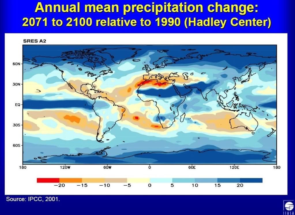
    None of that is true. The IPCC predict total world agricultural output to increase as CO2 levels increase. Rainfall is due to increase too. Where do you get mass starvations and drought from? Al Gore?

    on agriculture:
    impacts on aggregate welfare are a small percentage of GDP and tend to be positive, especially when the effects of CO2 fertilization are incorporated.
    on rainfall:
    IPCC.jpg

    Important to note that the IPCC assume no irrigation in their estimates.

    As for extremes in weather thats a farce. Weather is fundamentally driven by the difference in temperature between the ICTZ and the poles. Its what creates high and low pressures. The poles are the areas heating up the most therefore the weather will in fact become calmer.


  • Registered Users Posts: 26,578 ✭✭✭✭Turtwig


    None of that is true. The IPCC predict total world agricultural output to increase as CO2 levels increase. Rainfall is due to increase too. Where do you get mass starvations and drought from? Al Gore?

    Uh,

    The IPCC said
    As discussed in WGI AR4 Technical Summary (Solomon et
    al., 2007) Box TS.5 and Table TS.4, various extreme events are
    very likely to change in magnitude and/or frequency and
    location with global warming. In some cases, significant trends
    have been observed in recent decades (Trenberth et al., 2007
    Table 3.8).
    The most likely changes are an increase in the number of hot
    days and nights (with some minor regional exceptions), or in
    days exceeding various threshold temperatures, and decreases
    in the number of cold days, particularly including frosts.
    These
    are virtually certain to affect human comfort and health, natural
    ecosystems and crops. Extended warmer periods are also very
    likely to increase water demand and evaporative losses,
    increasing the intensity and duration of droughts, assuming no
    increases in precipitation.

    Precipitation is generally predicted in climate models to
    increase in high latitudes and to decrease in some mid-latitude
    regions
    , especially in regions where the mid-latitude westerlies
    migrate polewards in the summer season, thus steering fewer
    storms into such ‘Mediterranean climates’ (Meehl et al., 2007
    Section 10.3.2.3). These changes, together with a general
    intensification of rainfall events (Meehl et al., 2007 Section
    10.3.6.1), are very likely to increase the frequency of flash floods

    and large-area floods in many regions, especially at high
    latitudes. This will be exacerbated, or at least seasonally
    modified in some locations, by earlier melting of snowpacks and
    melting of glaciers. Regions of constant or reduced precipitation
    are very likely to experience more frequent and intense droughts,
    notably in Mediterranean-type climates and in mid-latitude
    continental interiors.

    Extended warm periods and increased drought will increase
    water stress in forests and grasslands and increase the frequency
    and intensity of wildfires
    (Cary, 2002; Westerling et al., 2006),
    especially in forests and peatland, including thawed permafrost.
    These effects may lead to large losses of accumulated carbon
    from the soil and biosphere to the atmosphere, thereby
    amplifying global warming (**) (see Sections 4.4.1, 19.3.5.1;
    Langmann and Heil, 2004; Angert et al., 2005; Bellamy et
    al., 2005).
    Tropical cyclones (including hurricanes and typhoons), are
    likely to become more intense with sea surface temperature
    increases, with model simulations projecting increases by midcentury
    (Meehl et al., 2007 Section 10.3.6.3).
    However, despite
    an ongoing debate, some data reanalyses suggest that, since the
    1970s, tropical cyclone intensities have increased far more
    rapidly in all major ocean basins where tropical cyclones occur
    (Trenberth et al., 2007 Section 3.8.3), and that this is consistently
    related to increasing sea surface temperatures. Some authors
    have questioned the reliability of these data, in part because
    climate models do not predict such large increases; however, the
    climate models could be underestimating the changes due to
    inadequate spatial resolution. This issue currently remains
    unresolved. Some modelling experiments suggest that the total
    number of tropical cyclones is expected to decrease slightly
    (Meehl et al., 2007 Section 10.3.6.3), but it is the more intense
    storms that have by far the greatest impacts and constitute a key
    vulnerability.
    The combination of rising sea level and more intense coastal
    storms, especially tropical cyclones, would cause more frequent
    and intense storm surges, with damages exacerbated by more
    intense inland rainfall and stronger winds
    (see Section 6.3.2).
    Increasing exposure occurs as coastal populations increase (see
    Section 6.3.1).
    Many adaptation measures exist that could reduce
    vulnerability to extreme events. Among them are dams to
    provide flood protection and water supply, dykes and coastal
    restoration for protection against coastal surges, improved
    construction standards, land-use planning to reduce exposure,
    disaster preparedness, improved warning systems and
    evacuation procedures, and broader availability of insurance and
    emergency relief (see Chapter 18). However, despite
    considerable advances in knowledge regarding weather
    extremes, the relevant adaptation measures are underused, partly
    for reasons of cost, especially in developing countries (White et
    al., 2001; Sections 7.4.3, 7.5 and 7.6). Despite progress in
    reducing the mortality associated with many classes of extremes,
    human societies, particularly in the developing world, are not
    well adapted to the current baseline of climate variability and
    extreme events, such as tropical cyclones, floods and droughts,
    and thus these impacts are often assessed as key vulnerabilities
    .


  • Closed Accounts Posts: 5 watts2434


    what the deal play boy, you make me laugh


  • Closed Accounts Posts: 5 watts2434


    2 stroke wrote: »
    Wow! How interesting. Here in Ireland we could flood Cork.
    i thought cork floated?


  • Registered Users Posts: 233 ✭✭maniac101


    Amhran Nua wrote: »
    Thats Lake Eyre, not the Eyre Basin. ;)


    Indeed?
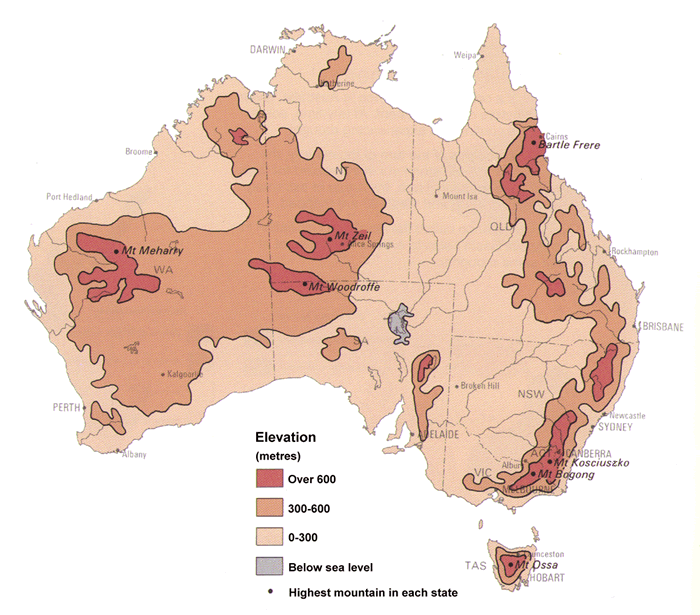
    Indeed! Here's a more informative map that clearly shows that only the lake area, which is a tiny part of the whole basin, is below sea level. (I've a more accurate digital version but I don't know how to post it). As mentioned earlier, the deepest part of the lake is 15m below sea level. However, the mean depth of the lake area would be no more than a couple of meters. The total volume of this small part of the basin is completely insignificant when compared to the vastness of the world's oceans.
    GA11759.gif
    None of that is true
    /yawns


  • Advertisement
  • Closed Accounts Posts: 4,124 ✭✭✭Amhran Nua


    maniac101 wrote: »
    Indeed! Here's a more informative map that clearly shows that only the lake area, which is a tiny part of the whole basin, is below sea level. (I've a more accurate digital version but I don't know how to post it). As mentioned earlier, the deepest part of the lake is 15m below sea level. However, the mean depth of the lake area would be no more than a couple of meters. The total volume of this small part of the basin is completely insignificant when compared to the vastness of the world's oceans.
    Alright so, we move to plan B - we nuke Belgium to a depth of 15m, and fill that in instead.

    Who's with me?


Advertisement