Advertisement
If you have a new account but are having problems posting or verifying your account, please email us on hello@boards.ie for help. Thanks :)
Hello all! Please ensure that you are posting a new thread or question in the appropriate forum. The Feedback forum is overwhelmed with questions that are having to be moved elsewhere. If you need help to verify your account contact hello@boards.ie
Hi there,
There is an issue with role permissions that is being worked on at the moment.
If you are having trouble with access or permissions on regional forums please post here to get access: https://www.boards.ie/discussion/2058365403/you-do-not-have-permission-for-that#latest

New roads/m-ways appearing on maps?

  • 05-04-2009 3:54pm
    #1
    Moderators, Education Moderators Posts: 5,028 Mod ✭✭✭✭


    How long after roads are built does it usually take for them to appear on google maps, sat-navs, osi maps etc??


Comments

  • Registered Users, Registered Users 2 Posts: 21,499 ✭✭✭✭Alun


    dannym08 wrote: »
    How long after roads are built does it usually take for them to appear on google maps, sat-navs, osi maps etc??
    Too long, usually :) With new bypasses and sections of HQDC and motorway appearing all the time it can get a bit difficult to get a good overview of the state of play on the major routes I find, personally. It'd be nice if the NRA would have a map of the whole country somewhere on their site giving an overview of the current progress on the major national routes.


  • Registered Users, Registered Users 2 Posts: 21,084 ✭✭✭✭Stark


    Google Maps are very inconsistent. The Gorey Bypass and the N1 Newry-Dundalk were on Google Maps before they opened. The M8 Cullahill-Cashel isn't on it yet. The Fermoy Bypass was only coloured blue last year despite being open as motorway for 2 years previously. And it's still listed as the "M8" rather than the "N8". In general, the motorway redesignations don't seem be reflected...

    Short answer: who knows?

    www.openstreetmap.org seems to be the most up to date when it comes to new motorways thanks to the rabid nerds on boards.ie hovering over it ready to upload new roads as soon as they open :)


  • Closed Accounts Posts: 6,093 ✭✭✭Amtmann


    Good man. This really does deserve its own thread. The M8 Cashel to Cullahill section opened on December 8 2008 and appeared on Google Earth last Friday - three days after I sent off an email to Google about it (probably a coincidence). However, it appears as a green N road, save for the bit beyond Urlingford which, if people remember, was supposed to be a motorway anyway. In addition, it is absent from Google Maps.The Cashel to Mitchelstown scheme appeared on Google Earth last November, and is also on Google Maps; however, it too is shown as a green N road, as is all of the M6 motorway. The M9 Carlow Bypass is also shown in green. The R639 is mis-named for much of its length too.

    Here are two business on the old N8 route have had to improvise waiting for google to update their information: http://www.rockwellcollege.ie/directions.html
    and see here: http://www.horseandjockeyhotel.com/w.../Location.html


  • Moderators, Education Moderators Posts: 5,028 Mod ✭✭✭✭G_R


    ye i sent an email to the company google uses to update its maps (teleatlas) ages ago. they sent me a link that they say will keep me updated as to the progress of my report, couple of months later it just says that they have recieved my report, but they cant see the problem so im convinvced that any emails you send them jus end up in some inbox somewhere and arent read by anyone.

    you would think that after spending however many million euro on road projects the govmt. would ensure that the OSI have up-to-date maps to along with them. Foriegn reg'd cars still come through Urlingford, and im assumung other bypassed towns, because (im assuming) their sat navs send them that way.


  • Registered Users, Registered Users 2 Posts: 71,182 ✭✭✭✭L1011


    Carlow Bypass was on Google Maps prior to opening also...


  • Advertisement
  • Closed Accounts Posts: 3,010 ✭✭✭Tech3


    Furet wrote: »
    The M8 Cashel to Cullahill section opened on December 8 2008 and appeared on Google Earth last Friday - three days after I sent off an email to Google about it (probably a coincidence).

    With Mitchelstown to Fermoy to be completed next month they would want to correct the map. It will leave the whole route with just the portlaoise-cullahil M8/M7 scheme and waterrgrasshill-dunkettle into cork. They are missing most of the M6 also on google maps. When/If the redesignations go ahead we will be waiting a while before we even see them on google maps.


  • Closed Accounts Posts: 3,082 ✭✭✭Chris_533976


    OSM is easily the quickest.

    www.openstreetmap.org

    Mainly because sad people go out and drive the routes the day they open solely to post them (I bags Galway - Ballinasloe BTW)


  • Closed Accounts Posts: 5,429 ✭✭✭testicle


    MYOB wrote: »
    Carlow Bypass was on Google Maps prior to opening also...

    It appeared the day it opened.

    Funnily enough, my TomTom has the Limerick to Nenagh M7 already, and it's not due to open for a long time...


  • Registered Users, Registered Users 2 Posts: 71,182 ✭✭✭✭L1011


    testicle wrote: »
    It appeared the day it opened.

    Funnily enough, my TomTom has the Limerick to Nenagh M7 already, and it's not due to open for a long time...

    Was definitely on it the week before opening if not earlier.


  • Closed Accounts Posts: 23,316 ✭✭✭✭amacachi


    The M1 around Dundalk was added and then removed before it opened.


  • Advertisement
  • Closed Accounts Posts: 6,093 ✭✭✭Amtmann


    At a time when Ireland needs more than ever to show to the world its competitiveness and ever-improving road network, it is very disappointing that communication between the Irish Department of Transport and various Internet mapping and GPS companies seems to be so poor. We have spent - and are spending - billions on creating a new motorway network, yet very little of this appears on Google Maps.

    While it is up to Google to update their own maps, it is obvious that it is in Ireland's strategic interest to encourage them to do so as soon as a new road opens. I believe the Department of Transport should share all road opening information (including co-ordinates and classification data) with Google as soon as possible. And vitally, Google must also be made aware of the recent changes made by Tranche 1 of the motorway redesignations.

    The tourist season is almost upon us; how many tourists (and foreign hauliers) will be led astray onto old detrunked N roads by obsolete GPS data? In addition, it should be of concern to the Irish Government that many businesses along detrunked routes are having to expend valuable resources on creating their own ad hoc maps, since Google is now unreliable and, indeed, getting more and more unreliable with each new road opening. AA Ireland's route planning section no longer functions accurately either.

    This, overall, is surely a little detrimental to our country's competitiveness in these difficult times. I would urge the Department of Transport to contact all GPS and Internet mapping companies without delay to ensure that they relay an accurate image of Ireland to the world.


  • Closed Accounts Posts: 6,093 ✭✭✭Amtmann


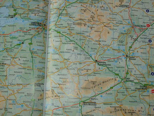
    Collins, my favourite map-makers, have just published a new (April 2009) Comprehensive Road Atlas of Ireland. See: http://www.amazon.co.uk/Comprehensive-Road-Atlas-Ireland/dp/0007312814/ref=sr_1_1?ie=UTF8&s=books&qid=1239015255&sr=8-1 I just ordered a copy.

    Their maps come in a nice A4 format and are extremely easy to read. Here's a page out of their 2007 Touring edition.
    3418006804_0c7f51d5a3.jpg

    Their next Touring Edition will be published in spring 2010.


  • Registered Users, Registered Users 2 Posts: 1,419 ✭✭✭Cool Mo D


    I happened to have a flick through the Collin's atlas in a bookshop yesterday. As far as I could tell at first glance, everything seemed correct, although if I remember correctly they have have the N9 marked as motorway under construction form Waterford to Carlow, even though I think it wasn't all redesignated last time. The current list of redesignations are not shown as motorway, so it may end up being out of date pretty soon.


  • Registered Users, Registered Users 2 Posts: 1,639 ✭✭✭Zoney


    Of course, call me crazy, but maybe we could have sufficient tax revenue taken to allow the funding of rather useful resources such as Ordinance Survey, rather than run them on a shoestring as semi-private companies that charge unreasonable commercial rates for use of mapping data.

    The same symptom is responsible for pathetic weather forecasts under the assumption that if you want better, you pay for ringing Weatherdial. Compare to the weather information provided for free by the UK met office:
    http://www.metoffice.gov.uk/weather/uk/ni/ni_forecast_weather.html
    http://www.metoffice.gov.uk/weather/uk/ni/belfast_forecast_weather.html
    I.e. Met Éireann have to be subsidised by private revenue raising.

    The lack of proper government revenue raising and funding of public services does of course more importantly affect far more serious issues such as health and education.

    Anyway, it boils down to that you can't have your cake and eat it too. If you are a supporter of our low-tax arrangements, then you have no grounds to grumble about the miserable maps produced by private companies.


  • Registered Users, Registered Users 2 Posts: 71,182 ✭✭✭✭L1011


    My AA map of all of Europe has all last years openings on it as DC whereas no OSI mapbook does; think that speaks volumes about the OSIs efforts...


Advertisement