Advertisement
If you have a new account but are having problems posting or verifying your account, please email us on hello@boards.ie for help. Thanks :)
Hello all! Please ensure that you are posting a new thread or question in the appropriate forum. The Feedback forum is overwhelmed with questions that are having to be moved elsewhere. If you need help to verify your account contact hello@boards.ie
Hi there,
There is an issue with role permissions that is being worked on at the moment.
If you are having trouble with access or permissions on regional forums please post here to get access: https://www.boards.ie/discussion/2058365403/you-do-not-have-permission-for-that#latest

All Ireland Ring Road - My suggestion

  • 09-08-2006 7:09pm
    #1
    Closed Accounts Posts: 3,082 ✭✭✭


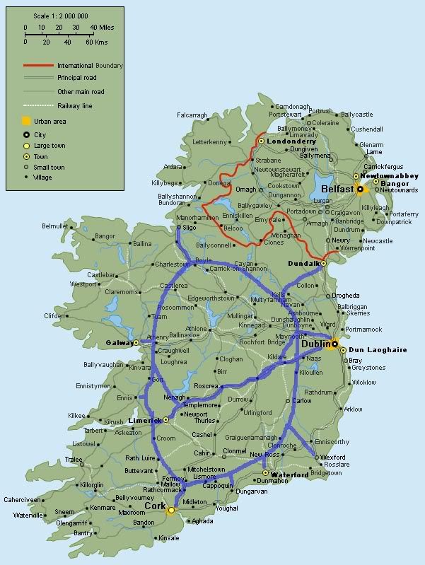
    Ok I know its late because of all the motorways being built, but does anyone else think that an idea like this would have been much much better than the patchwork being done at the moment?

    Heres a map of Ireland with a big ring road built through the whole country. It serves every major city they're trying to connect at the moment. Its far more efficient, avoids all the major problems they're facing at the moment, and would relieve traffic congestion near the bigger cities. The only thing thats familar about this map is the motorway from Limerick to Dublin. Thats the only part they've got right so far ;)

    Anyone any comments? Obviously the blue is where I'd plan to build the motorway. It doesnt go through any big towns for a reason, but is easily accessible from feeder roads from the towns.

    I was bored, so I made this. Comments? :)

    ringroad.jpg

    Its only approximate so dont shoot me for errors ;)

    Extra roads around Dublin to connect the N7 and N4. Extra spur near Limerick to facilitate Dublin - Galway.


Comments

  • Closed Accounts Posts: 88,972 ✭✭✭✭mike65


    Jayus! A mega motorway crashing through Lismore and Griaguenamanagh! :eek: Why is Waterford defined as a town!!!!!!?

    Mike.


  • Registered Users, Registered Users 2 Posts: 738 ✭✭✭bbbbb


    It's a bit of a road to nowhere?

    Dublin-Galway, my main route, is very poorly served :(


  • Banned (with Prison Access) Posts: 13,018 ✭✭✭✭jank


    Looks like a 2 minute job.

    Cork a large town too??


  • Closed Accounts Posts: 1,065 ✭✭✭Maskhadov


    looks like a road going to no where.. full marks for thinking something orignal like that up but if it ever went ahead it would be a laughing stock around the world.


  • Closed Accounts Posts: 88,972 ✭✭✭✭mike65


    It does'nt go no-where is goes everwhere except the northwest and the south west and...!

    Mike.


  • Advertisement
  • Registered Users, Registered Users 2 Posts: 11,005 ✭✭✭✭Flukey


    A bit of a back of an envelope job there. Did you ever think of standing for election?


  • Closed Accounts Posts: 1,065 ✭✭✭Maskhadov


    Travelling Dublin - Galway looks like a 2 day job.


  • Closed Accounts Posts: 3,082 ✭✭✭Chris_533976


    Ok get rid of the Nenagh - Gort spur and put a Roscrea - Galway spur.

    For a start my idea gets rid of the need for an M8 and M9. Both are in one with little distance change :)


  • Registered Users, Registered Users 2 Posts: 21,107 ✭✭✭✭Stark


    Maskhadov wrote:
    looks like a road going to no where.. full marks for thinking something orignal like that up but if it ever went ahead it would be a laughing stock around the world.

    The "Ireland Bypass" :)


  • Closed Accounts Posts: 130 ✭✭Fool 5000


    Maybe this one..Errr no :rolleyes:


    ire.jpg


  • Advertisement
  • Registered Users, Registered Users 2 Posts: 7,476 ✭✭✭ardmacha


    An All Ireland ring road that doesn't visit several of the most populous counties and the second biggest city. This is a joke, right?


  • Closed Accounts Posts: 1,026 ✭✭✭imeddyhobbs


    athlone and mullingar...is they black?


  • Registered Users, Registered Users 2 Posts: 78,610 ✭✭✭✭Victor


    athlone and mullingar...is they black?
    No, Jewish.


  • Registered Users, Registered Users 2 Posts: 1,108 ✭✭✭nordydan


    Hmm, not really all-ireland now is it? Even the map with the transatlantic pan-eskimo highway to Greenland made more sense.


  • Registered Users, Registered Users 2 Posts: 4,282 ✭✭✭westtip


    This ring road is a cracking plan: All motorways currently built should be dug up to implement this plan immediately. Failte Ireland can get busy on promoting the Ring of Ireland (eat your hearts out Kerry your ring is no more). It looks good for Sligo but not many other places (suits me sir), but I can't see the people of Navan agreeing.

    Thanks for giving us all a good laugh anyway. Although seriously there are some merits in the idea - some of which were debated in the thread re the James Nix article in the Irish Times in 2003 - see thread All roads lead to Dublin.

    If you can redraw your plan with three EAST/WEST routes:

    1 Sligo/Dundalk (via Enniskillen, Monaghan to Dundalk - yes OK we would need NI/ROI cooperation)

    2 Galway/Dublin (prety much as the N4/6

    3 Cork/Waterford Enniscorthy

    and join the ends up with two north south axial routes either side of the country - on the east the M1/M50/M11 is pretty much there for you and on the west the Atlantic corridor route from Letterkenny/Sligo/Galway/Limerick/Cork then IMO your ring idea has some merits.

    A few spurs here and there to join towns to the system may have worked.

    Hey who needs the NRA and all those transport planners - all they have to do is look at these boards for the great ideas.

    By the way where are the toll snarl ups going to be???


  • Closed Accounts Posts: 27,857 ✭✭✭✭Dave!


    It's a good idea if a bit more thought went into it! So let's hide the idea while FF are in power ;)


  • Closed Accounts Posts: 17,733 ✭✭✭✭corktina


    as i recall, the plan as now is to construct a motorway/first class dual carriageway box around Ireland........


  • Registered Users, Registered Users 2 Posts: 1,108 ✭✭✭nordydan


    Derry-Belfast-Waterford will be DC/M and GSJ'ed, about a third of Waterford-Cork, the Cork bypass (N or S), Cork-Limerick-Galway also. From Galway - SLigo, well Galway to tuam and sligo to cooloney will be DC, the rest being high standard road. Then a new DC to the end of the Bundoran bypass, and the rest to Derry will be HQ road.

    If you want to adopt the D4, west brit, daddy's credit card approach, well there will be a completely redesigned N16, south enniskillen bypass, and upgraded A4, N2, (maybe) N53 to Dundalk and back to Dublin.

    Either of these will be more sensible than that abomination at the start of this thread.


  • Closed Accounts Posts: 624 ✭✭✭Aidan1


    Problem with the AIRR(TM) is precisely the same as the one with Nix's proposal. They both completely ignore the existing population and industrial geographies of Ireland.

    I think its been mentioned here already, but you don't design a transport network for an idealised version of reality, you design the network to fit reality, and ideally to improve on it. The problem with not having all roads leading to Dublin (and designing a grid, lattice, waffle or whatever your having yourself) is that, well, all roads do lead to Dublin. Our population is distributed mainly in a small number of urban settlements around our coast, a fact that is getting even more pronounced. Dublin is by far the largest of these, hence, guess what! A radial roads network!

    (and now for the chorus)

    Proper transport and landuse planning would mitigate many of the problems inherent to such a system. A coherent policy on residential zoning in peri-urban areas, and the provision of sufficient quantities of land zoned for density, well serviced by a functioning and integrated public transport system would be a great start.

    If you really want to Drive from Galway to Dublin via Limerick (or Cork-Dublin vis Waterford), then the branding exercise that is the 'Atlantic Corridor' will facilitate same.


  • Registered Users, Registered Users 2 Posts: 19,777 ✭✭✭✭road_high


    Aidan1 wrote:
    Problem with the AIRR(TM) is precisely the same as the one with Nix's proposal. They both completely ignore the existing population and industrial geographies of Ireland.

    I think its been mentioned here already, but you don't design a transport network for an idealised version of reality, you design the network to fit reality, and ideally to improve on it. The problem with not having all roads leading to Dublin (and designing a grid, lattice, waffle or whatever your having yourself) is that, well, all roads do lead to Dublin. Our population is distributed mainly in a small number of urban settlements around our coast, a fact that is getting even more pronounced. Dublin is by far the largest of these, hence, guess what! A radial roads network!

    (and now for the chorus)

    Proper transport and landuse planning would mitigate many of the problems inherent to such a system. A coherent policy on residential zoning in peri-urban areas, and the provision of sufficient quantities of land zoned for density, well serviced by a functioning and integrated public transport system would be a great start.

    If you really want to Drive from Galway to Dublin via Limerick (or Cork-Dublin vis Waterford), then the branding exercise that is the 'Atlantic Corridor' will facilitate same.

    I concur.To build the roads in this manner would exclude so many towns along the east, south and midlands from the motorway network, despite the fact towns like Portlaoise, Kilkenny, Athlone etc are in fact where the MAJORITY of traffic on the N roads orriginates.

    My point being if one was to only count the traffic numbers travelling solely (i.e. long distance) between Dublin and Cork for instance and build to road to solely meet these needs then you would have a very lighly trafficed motorway.The vast majority of journeys on the N roads are between towns and cities close to each other, say 15,20, 40 miles apart.The N routes under the NDP cater very well for such journeys as this is where principle demand lies.


  • Advertisement
  • Closed Accounts Posts: 41 Happy Bertie


    One of the primary purposes of a motorway is to increase the transportation efficiency of a country/region. A motorway is in fact a success if it draws more traffic to it. The M50 is in actual fact a success, so successful that they need to double its capacity. If the goal is to have least traffic then the "Ring of Ireland" proposal would fulfill that objective.

    What might merit series consideration is to develop a new center of transportation in Ireland, say in Portlaoise with a radial to Athlone via Tullamore and a radial north to Mullingar and a radial to Kilkenny. The benefit of this is that it would complement the existing infrastructure. These new radials could initially be single-carraigeway with enough land set aside for future upgrade to dual carriageway. Wearhouses, supply centers could located in Portlaoise, which is probably the center of gravity for Ireland in a population context. (Operations Research students will know what I'm talking about) See the map.
    roadsproposal1.JPG


  • Registered Users, Registered Users 2 Posts: 19,777 ✭✭✭✭road_high


    One of the primary purposes of a motorway is to increase the transportation efficiency of a country/region. A motorway is in fact a success if it draws more traffic to it. The M50 is in actual fact a success, so successful that they need to double its capacity. If the goal is to have least traffic then the "Ring of Ireland" proposal would fulfill that objective.

    What might merit series consideration is to develop a new center of transportation in Ireland, say in Portlaoise with a radial to Athlone via Tullamore and a radial north to Mullingar and a radial to Kilkenny. The benefit of this is that it would complement the existing infrastructure. These new radials could initially be single-carraigeway with enough land set aside for future upgrade to dual carriageway. Wearhouses, supply centers could located in Portlaoise, which is probably the center of gravity for Ireland in a population context. (Operations Research students will know what I'm talking about) See the map.
    roadsproposal1.JPG

    Like the look of this, but then I would say that as I live in Kilkenny!!
    The N80 north of Portlaoise needs and should get serious investment as outlined.

    South of Portlaoise it's a bit of a split between going via Carlow or via Kilkenny to link up with the N9 (and further on the N11 and N25). I would imagine the Carlow spur would get the thums up over the Kilkenny spur as it would link with Rosslare more directly.
    But then again the KK option would provide the whole Midalnds with a decent and high quality direct link to Waterforfd city and port.Something which is badly needed in my view.


  • Registered Users, Registered Users 2 Posts: 678 ✭✭✭jmkennedyie


    Folks, don't forget the outer orbital route. NRA got explicit funding last budget to work out a route or routes, didn't they?

    As far as I recall, basically Drogheda / Navan / Kilkock or Maynooth / Naas and maybe beyond...

    Anyone know status of this?


  • Closed Accounts Posts: 5,133 ✭✭✭mysterious


    Well here's a mix and match.

    The majority of the inter urban routes go as planned. As 50% of it's already on it's way at this stage.

    I included the Outer orbital route. I think it's logical to pick a route along this aspect, as it connects to the M9 and M7, which therefore, connects the southern provinces to the rest of Ireland without having to add another spur like the above pic etc... It will also steer interurban and North south traffic from radiating towards the congested M50. I also think it's vital for an Outer urban route go ahead, partly because the fact is, it's a densly populated area, and need better infastructure regardless.

    I would have a major intersection Near Cahir or thereabouts where the N24 and N8 intersects already. As it would negotiate traffic from Galway/Limerick and Cork and waterford to go in any direction to all the cities, greatly echoing the efficiecy/importance of the Atlantic corridor. If that explains it. Thus no need for N25 or N20 for most of it's length. It's a little longer though but economical and logical. If there were mountains in the way of the current N25 near Dungarvan it would be no big deal to reroute it to the W-C traffic to Mitchellstown and onto the N24 in a realigned aspect (as I believe it was an alternate route to W) Cork - Clonmel/Kilkenny trafficwould benifet too, thus, being closer to all the regional cities. I think an interchange like this would be very a great advantage. It would save alot of money. It would mean greater capacity, justify for more traffic and bring the regions closer together.The extra money could go into a first class rail corridor to connect the regions. This is another bonus.

    Also a road that was favoured by the Nra is the Sligo to Dundalk route. This route should begin along the Atlantic coast to connect all the Coastal towns from south and west of Ireland to the North of Ireland, This side of the country is limited in access to the North compared to the east coast. It will eliminate the need for the populations of let's say Galway or Limerick to travel east and swing north enroute to let's say Belfast. This would ease pressures off the eastern seaboard and balance development evenly. I also think it's important to have another east west route at that part of the country.

    Edit: Also I forgot to mention the East west route. This would also allow Dublin Sligo traffic to go via the M3(which I don't agree with having, but it's going ahead now) proceed in a northwesterly direction to join onto the East west corridor and than travel westwards and interesect with existing upgraded Boyle N4 to Sligo , this would act as a spur that will connect Sligo to the rest of the country. I'm probably not the best at explaining things, but you can judge from the map! Also it will give the Northwest region a motorway instead of having to spend millions on the N4 north of Mullingar etc.

    Anyway I hope my ideas are clear, this is just a load of plans thrown together.


  • Registered Users, Registered Users 2 Posts: 4,282 ✭✭✭westtip


    mysterious wrote:
    Well here's a mix and match.

    Also a road that was favoured by the Nra is the Sligo to Dundalk route. This route should begin along the Atlantic coast to connect all the Coastal towns from south and west of Ireland to the North of Ireland, This side of the country is limited in access to the North compared to the east coast. It will eliminate the need for the populations of let's say Galway or Limerick to travel east and swing north enroute to let's say Belfast. This would ease pressures off the eastern seaboard and balance development evenly. I also think it's important to have another east west route at that part of the country.

    .

    When was this East west route straddling the BMW region advocated or favoured by NRA, this is something I have gone on about on these boards and I can't recall the NRA having it their current stable of ideas. Would love to see it BTW.


  • Closed Accounts Posts: 88,972 ✭✭✭✭mike65


    So Rosslare port (271,966 vehicle movements in 2005) would have no decent road in either direction?

    Mike.


  • Registered Users, Registered Users 2 Posts: 78,610 ✭✭✭✭Victor


    westtip wrote:
    When was this East west route straddling the BMW region advocated or favoured by NRA,
    I think the east-west route favoured by hte NRA is Belfast-Sligo.


  • Registered Users, Registered Users 2 Posts: 1,108 ✭✭✭nordydan


    Victor wrote:
    I think the east-west route favoured by hte NRA is Belfast-Sligo.

    In relation to this corridor there are a number of schemes in the planning. The first stage is a realighment of the N16 from Sligo town to the county border. As this will swing north and join the N15 a few miles north of the town instead of ploughing straight into Sligo itself, this is dependent on the new N15 Sligo to Bundoran DC scheme. This new N15 scheme has been split into 3 stages, the first of which will run from the end of the IRR to about 4 miles north of Sligo and will commence in a number of years. Hence the new N16 Sligo county scheme cannot proceed before this one, and will be of lower priority than the completion of the N15.
    There are a number of schemes in Leitrim, there is a new Manorhamilton bypass and Manorhamilton to Glenfarne scheme. They are not expected before 2019, similar to the Enniskillen and Fivemiletown bypasses. So some way off yet for this section.

    I received word from county council that there are plans to upgrade the N53 to Carrickmacross from Dundalk, hence it would appear that the East-West corridor at this latitude will be as before - Sligo>Monaghan>Ballygawley>Sligo or N53>N2>A5>A4>N16>N15


  • Registered Users, Registered Users 2 Posts: 4,282 ✭✭✭westtip


    Nordy, it all seems a long way off!! what a surprise. By the time it is scheduled to be built or put together another priority for the greater dublin area will have been found - perhaps the extension of LUAS to Athlone or Salthill. What I would like to see is a new route from Brookeborough on the A4 through to Monaghan. This would give us a true E/W link road in the BMW region. dream on.

    By the way Nordy what do you think the best route from Sligo to Drogheda is - I usually do N4 to Mullingar and across - and have never tried the northern traverse and down would it be any better these days?


  • Advertisement
  • Registered Users, Registered Users 2 Posts: 1,108 ✭✭✭nordydan


    westtip wrote:
    Nordy, it all seems a long way off!! what a surprise. By the time it is scheduled to be built or put together another priority for the greater dublin area will have been found - perhaps the extension of LUAS to Athlone or Salthill. What I would like to see is a new route from Brookeborough on the A4 through to Monaghan. This would give us a true E/W link road in the BMW region. dream on.

    Quells surprise indeed. At least part of this scheme, Dungannon-Ballygawley and the first part of the N15 to a place called "Shannon Eighter" (dunno exactly where it is) will commence inside the next few years. I have obtined a map of the new N15 which will run further inland right beside Ben Bulben. When built it will speed up Sligo to Bundoran traffic dramatically, 20 minutes max I reckon even at peak times. The new N16 is a logical addition and combined with the other schemes will make Sligo to the border a very fast run indeed.
    I cannot see DC from Sligo to Belfast in the near future, it would make the trip possible in less than 2 hours though.

    Once the M50 in Dublin is complete, the interurbans will also be complete (in theory), including the Galway bypass which will start construction inside the next two years and Dublin-Gorey. The next stage then seems to be in improving access routes to the provinicial cities, filling in the gaps is the last stage and hence a long way off.


  • Registered Users, Registered Users 2 Posts: 78,610 ✭✭✭✭Victor


    nordydan wrote:
    including the Galway bypass
    The Galway City bypass is a lot further away than that.


  • Registered Users, Registered Users 2 Posts: 1,108 ✭✭✭nordydan


    Victor wrote:
    The Galway City bypass is a lot further away than that.

    Received 4 days ago with route map PDF.

    "Daniel,

    I attach copy of Preferred Route for proposed N6 GCOB, Rev K dated June 2006. The CPO and EIS are scheduled to be published in September 2006 and construction is scheduled to start in 2008.

    XXX,

    Project Engineer,

    N6 GCOB."

    PS This road is DC throughout and will freeflow onto the N6 Galway-East Ballinasloe. It is GSJ'ed until you reach the N59, then there are at grade roundabouts until you hit the coast road at Galway Bay


  • Registered Users, Registered Users 2 Posts: 7,476 ✭✭✭ardmacha


    nordydan
    N53>N2>A5>A4>N16>N15

    Are you sure about this. The N53 is the Dundalk-Castleblayney rd that passes through S. Armagh and is the shortest way to the N2. I have seen a previous route for the Dundalk-Sligo as Dundalk-Carrickmacross-Cavan-Enniskillen-Sligo. However Dundalk-Cavan is not presently a national route. There should be a proper Monaghan-Enniskillen route not passing through Aughnacloy, which adds significant distance.


  • Registered Users, Registered Users 2 Posts: 4,282 ✭✭✭westtip


    ardmacha wrote:
    nordydan


    There should be a proper Monaghan-Enniskillen route not passing through Aughnacloy, which adds significant distance.

    Absolutely - Brookeborough - Monaghan jumps out as a route when you look at a map. Trouble is it won't come about without significant cross border co-operation, and I cannot see it being a priority for the NI roads authorities. If we take a dublin centric view here they take a Belfast centric view of how the roads should be planned and developed in the north It all ultiumately means that despite grand gesturing and what amounts to Bull sh*t from our politicians they don't give a monkeys about the BMW region and probably never will (on both sides of the border by the way)


  • Registered Users, Registered Users 2 Posts: 1,108 ✭✭✭nordydan


    ardmacha wrote:
    nordydan


    Are you sure about this. The N53 is the Dundalk-Castleblayney rd that passes through S. Armagh and is the shortest way to the N2. I have seen a previous route for the Dundalk-Sligo as Dundalk-Carrickmacross-Cavan-Enniskillen-Sligo. However Dundalk-Cavan is not presently a national route. There should be a proper Monaghan-Enniskillen route not passing through Aughnacloy, which adds significant distance.


    Sorry I meant Castleblaney!


  • Advertisement
  • Registered Users, Registered Users 2 Posts: 78,610 ✭✭✭✭Victor


    nordydan wrote:
    I attach copy of Preferred Route for proposed N6 GCOB, Rev K dated June 2006. The CPO and EIS are scheduled to be published in September 2006 and construction is scheduled to start in 2008.
    O_o!


  • Registered Users, Registered Users 2 Posts: 1,108 ✭✭✭nordydan


    Victor wrote:
    O_o!

    See I know these things!!!

    This probably means that the bypass is part of the interurban.

    Re: the N53. I have just checked the map of the new Castleblaney bypass and the N53 is not being realigned to bypass the town. So maybe this is an indiactor that either the N53 will be upgraded in one scheme, or that it isnt part of the pan border highway after all (?)


  • Closed Accounts Posts: 3,082 ✭✭✭Chris_533976


    Can you upload that Galway PDF? Would be interesting to see it.


  • Registered Users, Registered Users 2 Posts: 1,108 ✭✭✭nordydan


    Can you upload that Galway PDF? Would be interesting to see it.

    Its quite large about 7MB, probably too big to attach. I got it and a few others simply by writing off to the council in question. They were very careful to state that they were preliminary and I got the impression that they were making an exception rather than doing this as a habit. I think they are more keen on letting members of the public come to the relevant office and viewing the plans. The Roads Design offices do not generally provide much information. Some would not send out electronic or paper versions of maps. Sad I know (;-)), but I others I got were (some are just preferred route corridors):

    <A1 Beech Hill-Loughbrickland (ie whats the delay)>
    "I refer to you request below regarding the A1 Loughbrickland to Beech Hill Dualling scheme. The 9.2km long upgrading to dual carriageway of the A1 from Loughbrickland to Beech Hill commenced on site in 2004. The northern section of the scheme totalling 4.5Km was completed and opened to traffic in December 2005. A significant archaeological find was made on the route of the road at Loughbrickland which, along with unforeseen ground conditions and service alterations has led to delays in the expected completion date. It is now envisaged that the scheme will be complete by the autumn."

    <DONEGAL SCHEMES (they don't send maps)>
    In response to your query regarding Donegal national road schemes, I have
    provided a summary of the current situation.
    -N14/N13 Jn. (Manorcunningham) to Strabane (and A5/N15 Link Road)
    EIS and CPO are being prepared and publication is currently programmed for
    2007. Construction is expected to follow in 2009 approximately.
    -N56 Mountcharles to Killybegs Junction (Five Points)
    The route selection phase has been completed for this scheme. Preliminary
    design for the first phase (Mountcharles to Inver) is underway and it is
    expected to reach the Part 8 planning process by November 2006 and CPO
    publication early next year. Construction start is estimated for mid-2008.
    Phase 2 (Inver to Five Points) will follow and initial construction start
    estimate is 2010.
    -N15 Ballybofey/Stranorlar Bypass
    CPO and EIS publication is expected in November 2006. Construction start is
    estimated to take place early in 2008, with a two year construction period
    anticipated.
    -N15 Lifford / Stranorlar / Ballybofey
    Route selection process has yet to be finalised. Next phase
    (CPO/EIS/Preliminary Design) to commence after N14/N13 Jn. to Strabane
    scheme ESI/CPO is published.
    Please note that all programme dates will depend on the availability of
    funding. Maps for the schemes are available for inspection at the National Roads Design Office. Please contact the office to arrange a suitable time for
    viewing. The NRDO cannot circulate copies of maps. Upon the publication of EIS and CPO, maps will be available on the website or hardcopy."

    <LAOIS SCHEMES>
    "Daniel,
    Thank you for your enquiry.
    The development of the Stradbally by-pass is developer led, meaning that when developers come forward with proposals to develop lands within the approved corridor for the by-pass (contained in the County Development Plan), they will be required to produce a Part VIII submission for the by-pass between certain agreed nodes. A route for a section of the Stradbally by-pass between the Portlaoise Road (N80) and the Vicarstown Road (R427) has been submitted for Part VIII planning permission. While the public display period finished last Friday 4th August 2006, the closing date for submissions on the proposed scheme is Friday 18th August. Once Part VIII planning permission has been secured, developers of lands along the approved route will be conditioned to construct the by-pass running through their site. Therefore there is no set timeframe for the construction of the route.
    Similarly the Portlaoise Northern Orbital Route is developer led so a timeframe for their completion is not set. There are no plans to connect directly with the motorway, but the orbital route will link to the Regional Road network near the Heath interchange.
    A line for the Mountmellick bypass will not be set until the Mountmellick Local Area Plan has been adopted this year. There is currently no timeframe for its completion."

    <CAVAN SCHEMES>
    Got paper copy of the Belturbet bypass and response:
    "N3 Realignment – Belturbet bypass
    There has been an objection in court seeking a judicial review of An Bord PLeananl decision. No clear program until court decision made. Projected timescale 2 years from commencement of construction. Will forward map by post if you let me have your postal address please.
    N3 Realignment – Virginia bypass
    Virginia By Pass – No date yet to progress - At best 2010 start
    Still has to go to public consultation – design not finalised yet."

    N2 Ardee Bypass (apparently on the Louth Co Co website but I couldnt find it)
    Got PDF map and response (also asked other queries):
    "In relation to mapping on the Ardee Bypass, I understand there is a map on the Louth Co. Co. website. Nevertheless I attach a location plan for your information. In relation to the A1/N1 Newry Link Road, it is proposed that this high grade dual carriageway will have a speed limit of 120 km/h up to the border. I hope this information proves helpful.
    ·The Ardee Bypass has recently gone through an ‘An Bord Pleanála’ oral hearing as part of a CPO process. If an Bord Pleanálá approve the scheme and finance is secured we hope to complete detail design and prepare to start work on site. If all goes as planned it is possible work on site could begin by the end of next year.
    ·The N53 (Dundalk Castleblaney Road) has a number of ‘low cost’ measures under way and in the planning stage. We are also exploring with our colleagues in the NRA what would be the best way to improve this corridor to national standards.
    ·Their in on-going cross border dialogue over a link across Carlingford Lough. In the recent past a preliminary study found a bridge option was more difficult and appeared to favor a ferry crossing.
    I hope this information proves helpful."

    <N6 Galway Bypass>
    Got PDF map and message:
    "I attach copy of Preferred Route for proposed N6 GCOB, Rev K dated June 2006. The CPO and EIS are scheduled to be published in September 2006 and construction is scheduled to start in 2008. I will refer your query below re N17 Oranmore to Tuam to my colleagues who work on that Scheme."
    <N17 Galway-Tuam>
    "Your query regarding the N17 Galway to Tuam Dual Carriageway was referred to me by my colleague. There is no electronic drawing of this scheme on the Galway County Council’s website but I will post a drawing of the scheme layout to the address you give below. As regards the timescale for this project it is anticipated to publish the CPO and EIS in 2007, first quarter. Construction is not expected to commence before 2010."

    <N15/N16 Sligo - Leitrim Co Boundary>
    Got 2 maps and response:
    "Please find attached maps outlining the N15 Preferred Route and also the N16. With regards the N16, a route selection report was carried out in 1996 from which a preferred route was adopted by the elected members and incorporated into the County Development Plan. However, to date, there has been no further progress on this as the NRA has not prioritized this scheme."

    <N16 Manorhamilton-Glenfarne>
    "I will email a pdf of the preferred route corridor brochure on Monday as i only have a paper copy of this at the moment. This is only a corridor and no actual detailed alignment has been designed for this section of road. In the NRA Road Needs Study this section of road was within construction period phase4 2015-2019.
    This was the expected construction period, at the time of publication, for this project. Unless circumstances change this project is not expected to commence within the near future."

    <N16 Kilmakerrill-Cornacloy>
    Got PDF (this is just a widening job) and response:
    "Please find attached Scheme Location map for the N16 Kilmakerrill Cornacloy Scheme which is approx 6km east of manorhamilton. This is really only a widening scheme on the existing N16 route. This scheme is not part of the N16 Manorhamilton to Glenfarne scheme for which the preferred route corridor has been selected."


  • Registered Users, Registered Users 2 Posts: 1,108 ✭✭✭nordydan


    <N17 Cooloney-Charlestown>
    Got paper PDF of map this morning and response(s) below:
    "I deal with the N4 Realignment – Cloonamahon to Castlebaldwin and also the N15 Sligo to County Boundary Realignment. With regards the N4 Realignment, information is currently being gathered for preparation of EIS and Preliminary Design is ongoing. In relation to the N15 Realignment a preferred route has been adopted by the elected members of the council. The next step is to get this route included into the current County Development Plan. This scheme has been split into three phases. It is envisaged that Phase 1 of this scheme which extends from Hughes Bridge to Shannon Eighter be constructed within the next two to three years. Preliminary Design has commenced on this scheme.
    The Route Selection Report for the N17 Realignment - Collooney to Charlestown road scheme was completed in May, 2001. The scheme comprises a realignment of a 25km section of the N17 National Primary route extending from Annaghmore, a location approximately 4km south of Collooney, to the eastern side of Curry village, and includes the bypassing of Ballinacarrow, Tubbercurry and Curry.
    The N17 Realignment - Collooney to Charlestown road scheme has been advanced through the constraints and route selection phases of the scheme development as a single scheme. However, the current budgetary constraints do not permit the entire scheme to be brought through the next stage of development. The current implementation plan, in accordance with the established priority of improvement needs identified by the NRA envisages that the scheme will be advanced through the preliminary design/land acquisition/EIS phase in three distinct stages, namely Collooney to Achonry, Achonry to Rathscanlon (Tubbercurry Bypass), and Rathscanlon to Charlestown.
    We are currently awaiting funding for the publication of an EIS (which has been prepared) on the Tobercurry Bypass section, while the other two schemes are currently progressing through preliminary design and EIS.
    Construction schedule on the particular route is funding dependant, therefore it is difficult to predict when each of the schemes will commence!
    I hope this info is of some help to you, feel free to contact me if you require any further information.
    The section between the Collooney Roundabout and Annaghmore will be retrofitted to suit a 2 plus 1 type road as per the rest of the proposed route, it is possible that this scheme will be carried in conjunction with the Collooney to Achonry section.
    The N17 Charlestown bypass is being supervised by MCC, but it is intended that if programmes run smoothly that both schemes would be tied in together!
    I can post out an OS map of the proposed route, if you would like to forward your address, otherwise feel free to call into our offices in the Market Yard."

    <N52 Tullamore to Mullingar>
    Got PRELIMINARY PDF map of the bypass and response below:
    "Tullamore Bypass
    A route is now decided upon. This will be a design and build contract. The contract is being prepared by our consultants and will be complete by year end 2006. Therefore, subject to funding, construction work on the ground may commence within the next twelve months, and be completed before end 2009. (I reiterate, that this is subject to funding.)
    N52 Tullamore - Kilbeggan
    The process to upgrade this road is underway. It may consist of an upgrading to the existing route or one of 5 new 'green field' proposals. We are at an early stage and no other specifics are available. Timeframe is unknown at this stage but 3-5 years would be a good guess (subject to funding)
    In addition there is no major road inprovments planned between Tullamore and Birr (and beyond) as i am aware, however many sections of this route are currently at quite a high standard, Local improvments will be ongoing.
    As the project is D/B and therefore, subject to detailed design at a later date, there is no exact route design available as yet. However the attached is a preliminary design and the best information available to us at the moment.
    N52 Mullingar Bypass extension
    The proposed link between the Lynn Road (N52) and Clonmore Industrial Estate (R390) will not be a national road and as such will not be funded by the National Roads Authority. It will be funded by grants from the Dept of Environment and Local Government and the Councils own resources. Given the extreme nature of the ground conditions - there is up to tne metres of peat on top of twenty metres of silt in places, the method of construction will dictate the timetable for the completion of this link. This has not yet been determined but various options are being examined at the moment and a decision will be made as soon as possible."

    <N20 Mallow-Croom>
    Got PDF map and response:
    "This is a map which will eventually be on the council website. The preferred route between Mallow and Croom has been chosen but there are no plans at present to construct any section of the scheme. The route between Blarney and Mallow will eventually be a dual carriageway but this if even further in the future than Mallow to Croom. All of these plans can however be changed by the departments of transport and finance depending on government income I will pass your email onto the various engineers who deal with the N22 and N28."

    If you want the map(s) it may be better to PM me and I will email them as I would imagine that the councils will stop providing information if a lot of requests come in. I will also be scanning the paper maps to send on to someone else. I am still waiting responses from a number of other councils, Wicklow, Monaghan, Roscommon Waterford and Meath. I can find no information on the rest of the N24, it must be on the back burner completely.


  • Advertisement
  • Registered Users, Registered Users 2 Posts: 19,777 ✭✭✭✭road_high


    Fair play Nordyan you've been busy!I can rarely get replies from these crowds, you must be special!
    Have you any info on road schemes in county Kilkenny, other than what is on the NRA site or the N9-N10 website?
    And wtf with the Stradbally bypass?Why shoud an N secondary road have to await developer submissions?I thought the point was to bypass the town, not create urban sprawl on a bypass around it!No wonder Co. Laois is turning into a new feckin Tallaght if that's the approach of hte county development plan!!
    Keep up the good work!


  • Registered Users, Registered Users 2 Posts: 1,108 ✭✭✭nordydan


    Must be the Kerry wit! I have no news in Kilkenny at all, I would imagine that the new N9 will drain all the funds and badly needed to. There is one town between Kilkenny that is like an 18th century bottleneck.

    Stradbally is a nice town, I especially like the descent into the town from the Carlow side. I was suprised that it didnt directly link to the M7, but i suppose that is to alleviate local traffic using the motorway as a short cut.

    All the info was recieved via email. I would particularly like info back from Monaghan but it must be holiday season there as my replies were bounced round a bit. A few phone calls may be in the offing.


Advertisement