Advertisement
If you have a new account but are having problems posting or verifying your account, please email us on hello@boards.ie for help. Thanks :)
Hello all! Please ensure that you are posting a new thread or question in the appropriate forum. The Feedback forum is overwhelmed with questions that are having to be moved elsewhere. If you need help to verify your account contact hello@boards.ie
Hi all! We have been experiencing an issue on site where threads have been missing the latest postings. The platform host Vanilla are working on this issue. A workaround that has been used by some is to navigate back from 1 to 10+ pages to re-sync the thread and this will then show the latest posts. Thanks, Mike.
Hi there,
There is an issue with role permissions that is being worked on at the moment.
If you are having trouble with access or permissions on regional forums please post here to get access: https://www.boards.ie/discussion/2058365403/you-do-not-have-permission-for-that#latest

M20 - Cork to Limerick [preferred route chosen; in design - phase 3]

19394969899170

Comments

  • Closed Accounts Posts: 2,553 ✭✭✭Cork Trucker


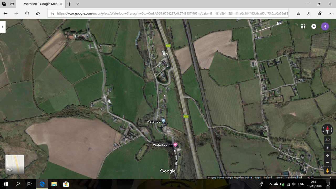
    I have heard that investigations by the Fire Service found that the Sat Navs in the affected cars showed the right turn off the N20 as a slip road rather than an actual junction with oncoming traffic.
    I must see what my own Sat Nav displays tomorrow when I'm passing.

    Yes I heard the same myself, this is clearly a major issue in these accidents, Where sat navs are concerned I assume there is no way to update them without plugging them into a computer?

    My own iPhone updates itself which is great but I reckon it will still direct me right to Blarney.


  • Closed Accounts Posts: 2,553 ✭✭✭Cork Trucker


    Isambard wrote: »
    waterloo.png


    I think so

    Looking at it I can't make out any other way how it may have looked bar what Marno showed, again while I was around pre N20 I don't remember it.

    Also on Kiln hill I think that junction is officially called, there is one or two houses up there so even if it were blocked off you'd have god knows how many vehicles driving up there for the first few weeks at least.

    My one fear being the driver of an artic who is foreign and can't read English will have to reverse the entire way back down.

    They will probably keep it blocked in a similar fashion to what it is now, maybe this was why it was closed so discreetly then the announcement they were to shut it altogether as it is already done effectively.


  • Registered Users, Registered Users 2 Posts: 4,561 ✭✭✭AugustusMinimus


    Isambard wrote: »
    taking into account the hilly nature, I can't see that being where the road ran. I think it's possible a road ran from the other side of the church but it must have been very minor.

    OSI Historic Map Viewer shows that Marnos drawing is correct.

    http://maps.osi.ie/publicviewer/

    Check out one of the old maps.


  • Registered Users, Registered Users 2 Posts: 5,795 ✭✭✭Isambard


    very interesting, I still think you can see another link on the photo though.

    Whatever, the way these junctions were done was very shoddy and has cost lives. They should all have been bridges / underpasses from day one.


  • Closed Accounts Posts: 2,553 ✭✭✭Cork Trucker


    How long did the N20 take to complete around there and what was the budget for the times?

    Looking bad they mad several errors that you wouldn't see today.

    Opened around 1990 i think.


  • Registered Users, Registered Users 2 Posts: 2,088 ✭✭✭Reputable Rog


    How long did the N20 take to complete around there and what was the budget for the times?

    Looking bad they mad several errors that you wouldn't see today.

    Opened around 1990 i think.

    It was considered fantastic when it opened, it was of its time and was built on a limited budget and took years.
    Nobody could have anticipated the massive growth in traffic and commuter patterns at the time.


  • Registered Users, Registered Users 2 Posts: 5,795 ✭✭✭Isambard


    I think closing the junction until the M20 works make it redundant anyway is the right decision . I shudder to think of the antics of people Uturning if they did otherwise


  • Registered Users, Registered Users 2 Posts: 365 ✭✭Frostybrew


    How long did the N20 take to complete around there and what was the budget for the times?

    Looking bad they mad several errors that you wouldn't see today.

    Opened around 1990 i think.

    I think this section opened in the mid 90's. Construction began around 88. Long builds were common back then. Glanmire bypass took from 85/86 to 1992, and was considered a white elephant by many, when first opened, due to lack of use.


  • Moderators, Entertainment Moderators, Science, Health & Environment Moderators Posts: 14,460 Mod ✭✭✭✭marno21


    Banning right turns at the Waterloo junction would have the net effect of the closure for the residents, as they are turning right to later turn left at the other junction down the road for Whitechurch. It's crossing the N20 is the issue for residents, not access to the N20
    It was considered fantastic when it opened, it was of its time and was built on a limited budget and took years.
    Nobody could have anticipated the massive growth in traffic and commuter patterns at the time.

    Indeed, it is a world apart from the old Mallow Road. It's still a disappointment that it wasn't dualled from Rathduff to Cork, as the road is certainly wide enough for it and they were dualling Blarney-Cork anyway.
    Frostybrew wrote: »
    I think this section opened in the mid 90's. Construction began around 88. Long builds were common back then. Glanmire bypass took from 85/86 to 1992, and was considered a white elephant by many, when first opened, due to lack of use.

    It is said elsewhere that work on the Glanmire bypass was stop start as work would be suspended for long periods until more funding was allocated. In fairness, Cork's roads got a lot of investment in the 1980s/1990s, the Glanmire BP, Mallow Road, South Ring Road, South Link Road, Jack Lynch Tunnel, N28 to Carrs Hill, Airport Hill widening, new road Ballinhassig-Halfway, East Cork Parkway etc.


  • Registered Users, Registered Users 2 Posts: 5,795 ✭✭✭Isambard


    marno21 wrote: »

    Indeed, it is a world apart from the old Mallow Road. It's still a disappointment that it wasn't dualled from Rathduff to Cork, as the road is certainly wide enough for it and they were dualling Blarney-Cork anyway.


    .

    Indeed and a great disappointment that the 2+1 further north was not rebuilt as a dual when they rebuilt the almost new road a year or two back, there's room for it I think.


  • Advertisement
  • Moderators, Entertainment Moderators, Science, Health & Environment Moderators Posts: 14,460 Mod ✭✭✭✭marno21


    Isambard wrote: »
    Indeed and a great disappointment that the 2+1 further north was not rebuilt as a dual when they rebuilt the almost new road a year or two back, there's room for it I think.
    There probably is room but it would have required closing junctions and removing right turns. Wouldn't be a popular move

    They'd have been better ripping up the wire and returning it to a WS2 with climbing lanes. The current setup is a mess, and borderline dangerous for a road with that volume of traffic.

    Thankfully the plan to put down 2+1 on many national roads was replaced with 2+2 back in the late 00s. Imagine the N20 had been replaced with a 2+1 from Blarney to Patrickswell.


  • Registered Users, Registered Users 2 Posts: 365 ✭✭Frostybrew


    marno21 wrote: »
    It is said elsewhere that work on the Glanmire bypass was stop start as work would be suspended for long periods until more funding was allocated. In fairness, Cork's roads got a lot of investment in the 1980s/1990s, the Glanmire BP, Mallow Road, South Ring Road, South Link Road, Jack Lynch Tunnel, N28 to Carrs Hill, Airport Hill widening, new road Ballinhassig-Halfway, East Cork Parkway etc.

    I'd say the Mallow road progress was something similar. Remember going for a walk on it back in 1990 during the summer. Half built earthworks and zero construction activity.


  • Registered Users, Registered Users 2 Posts: 5,795 ✭✭✭Isambard


    marno21 wrote: »
    There probably is room but it would have required closing junctions and removing right turns. Wouldn't be a popular move

    They'd have been better ripping up the wire and returning it to a WS2 with climbing lanes. The current setup is a mess, and borderline dangerous for a road with that volume of traffic.

    Thankfully the plan to put down 2+1 on many national roads was replaced with 2+2 back in the late 00s. Imagine the N20 had been replaced with a 2+1 from Blarney to Patrickswell.

    it achieves the object of preventing right turners from being rear-ended but creates other problems such as a simple shunt shutting the road or one tractor holding up 100 cars. I can never understand why they replaced the barriers when they resurfaced when there are several climbing lanes on the same road without them, and what's more these have been resurfaced without them also.

    Roll on the M20


  • Registered Users, Registered Users 2 Posts: 4,561 ✭✭✭AugustusMinimus


    That cheese wire is beyond lethal for bikers. Should be banned outright with a retro fitting programme replacing all sections with Armco or concrete nationwide.


  • Registered Users, Registered Users 2 Posts: 4,561 ✭✭✭AugustusMinimus


    Another interesting point to note is that a further junction for the same road was closed when the new road opened in the early 90s. It’s a few miles up the road towards Rathduff. There is a significant tunnel under the railway on the other side.

    Wonder was their complaints when this one closed back in the day.


  • Closed Accounts Posts: 2,553 ✭✭✭Cork Trucker


    It was considered fantastic when it opened, it was of its time and was built on a limited budget and took years.
    Nobody could have anticipated the massive growth in traffic and commuter patterns at the time.
    You're right about no one knowing the future, Ireland was a very different country even back then.
    Isambard wrote: »
    I think closing the junction until the M20 works make it redundant anyway is the right decision . I shudder to think of the antics of people Uturning if they did otherwise
    And you will get people who'll try a U turn to try and save time, i see it on the South City Link, Commons Road etc.
    Frostybrew wrote: »
    I think this section opened in the mid 90's. Construction began around 88. Long builds were common back then. Glanmire bypass took from 85/86 to 1992, and was considered a white elephant by many, when first opened, due to lack of use.

    I remember going as far as Blarney on that road in the very early 90's, no later than 1992 for certain.

    The Glanmire Bypass i remember being built.


  • Closed Accounts Posts: 2,553 ✭✭✭Cork Trucker


    That cheese wire is beyond lethal for bikers. Should be banned outright with a retro fitting programme replacing all sections with Armco or concrete nationwide.

    Lucky this wasn't a fatality in Rathduff last year.

    http://www.thejournal.ie/garda-motorcyclist-injured-after-coming-off-bike-3630973-Oct2017/


  • Registered Users, Registered Users 2 Posts: 2,088 ✭✭✭Reputable Rog


    That cheese wire is beyond lethal for bikers. Should be banned outright with a retro fitting programme replacing all sections with Armco or concrete nationwide.

    And how long would it take to retrofit? Can't cope with the endless roadworks.


  • Moderators, Entertainment Moderators, Science, Health & Environment Moderators Posts: 14,460 Mod ✭✭✭✭marno21


    Isambard wrote: »
    it achieves the object of preventing right turners from being rear-ended but creates other problems such as a simple shunt shutting the road or one tractor holding up 100 cars. I can never understand why they replaced the barriers when they resurfaced when there are several climbing lanes on the same road without them, and what's more these have been resurfaced without them also.

    Roll on the M20

    They should just return it to WS2, climbing lanes or no climbing lanes. The overtaking areas are useless anyway because you can overtake 4/5 cars only to be still going at the same speed when it goes back to 1 lane.

    Roads such as Cork-Mallow are not suitable for 2+1 and the persistence in using it is ridiculous. Too much traffic, too many junctions
    And how long would it take to retrofit? Can't cope with the endless roadworks.

    Should've been done in 2015/16 when they created endless delays for what seemed like forever to put down brand new cheese wire


  • Advertisement
  • Registered Users, Registered Users 2 Posts: 5,795 ✭✭✭Isambard


    that's why I was surprised they renewed it instead of giving up on a failed experiment. It would have save money too, that barrier must have cost a mint


  • Registered Users, Registered Users 2 Posts: 2,088 ✭✭✭Reputable Rog


    The overtaking lanes are useless in the wet, particularly when overtaking trucks. The spray makes it very difficult.


  • Moderators, Entertainment Moderators, Science, Health & Environment Moderators Posts: 14,460 Mod ✭✭✭✭marno21


    By the way, here's an update on the N20 from Cork County Council, from August 19th 2003 (15 years ago Sunday)
    N20: The planning and design of the section from Newtwopothouse to Croom is being progressed and is at the stage of selecting route options. This section will encompass By-Passes of Buttevant and Charleville. Pavement upgrading is continuing on the section from Mallow to Newtwopothouse.

    For reference sake, planning and design of the M20 will begin with selecting route options in September 2018.


  • Registered Users, Registered Users 2 Posts: 5,795 ✭✭✭Isambard


    as an aside, it looks tonight as if they might be finished with the roadworks. about 2 weeks early if they are


  • Registered Users Posts: 70 ✭✭lansing


    On the Waterloo junction issue:

    It appears that the authorities have made little consideration to the patrons who use the Waterloo / N20 junction on a daily basis. The closure seems to based on the assumption that everyone who is using the Waterloo Rd is destined for Blarney village and nowhere else. This is simply not true.


  • Registered Users, Registered Users 2 Posts: 8,615 ✭✭✭grogi


    lansing wrote: »
    On the Waterloo junction issue:

    It appears that the authorities have made little consideration to the patrons who use the Waterloo / N20 junction on a daily basis. The closure seems to based on the assumption that everyone who is using the Waterloo Rd is destined for Blarney village and nowhere else. This is simply not true.

    The junction is beyond unsafe. The authorities have made a lot consideration to the health and safety o the patrons, who will not be able to use this death-trap now.


  • Advertisement
  • Moderators, Entertainment Moderators, Science, Health & Environment Moderators Posts: 14,460 Mod ✭✭✭✭marno21


    grogi wrote: »
    The junction is beyond unsafe. The authorities have made a lot consideration to the health and safety o the patrons, who will not be able to use this death-trap now.
    The main cause of crashes at this junction appears to be drivers unfamiliar with the area using the Waterloo Road to access Blarney because their sat nav is telling them to do so.

    It's not by people who are driving from Waterloo to Whitechurch, some of whom have been using the junction for 28 years now and were happily using the old L road between Waterloo and the old Mallow Road before then.

    There's an easily solution to this. Widen the N20 to motorway width, realign it to motorway standards, close off all local accesses and place bridges where required to provide suitable local access.


  • Moderators, Entertainment Moderators, Science, Health & Environment Moderators Posts: 14,460 Mod ✭✭✭✭marno21


    History of the Cork Mallow Road (which has been the subject of debate here recently)

    Timeline
    1730's Turnpike road between Cork and Mallow laid down.
    1805 - Cork Mallow Road improvements start, to follow land contours for horse drawn carriages and wagons of 1800’s.
    1816 - Cork Mallow road opened by the Mail Coach.
    1962 - Publication of proposals for a new route
    1966 - Proposals shelved due to pressure from landowners and commercial interests.
    1970 - A Road Inventory by An Foras Forbarthas highlighted the deficiencies of theCork - Mallow route.
    1971 - 76 Re-examination of possible routes for improving the N20.
    1977 - Design team located in Council Divisional Office, in Mallow.
    1978 - 3kms of land acquired outside Mallow.
    1979 - Acquired lands from Ballinamona to Lissard.
    1980 Jan.- Construction started.
    1981 April - First section opened between Robbs Bridge outside Mallow and Ballynamona. It was 2kms in length.
    1981 - Mallow Road Report recommended a route following the railway line and incorporating the Blarney to Cork road.
    1983 June - Second section opened between Ballynamona and Ivy House Bridge.
    1984 - Bought lands from Lissard to eastern end of HGW premises in Blackpool.
    1986 June - Mallow Bypass opened.
    1989 - Mallow to Glancam completed at cost of £23 million
    1989 April - Glancam to Cork commenced.
    1994 - Glancam/Blarney/Cork completed.
    1994 Oct.- Opening of Phase Two of the Cork Mallow Road Project by Minister for the Environment Mr. Michael Smith, T.D.


    Annual average daily traffic: 9,645 vehicles in 1996
    * 30% HGV during beet campaign at Mallow Factory.
    * Cost of Construction: 67 million pounds.
    * 303.5 hectares acquired for the overall project.
    * Largest Civil Engineering Construction Project undertaken in Cork so far.
    * Old Cork Mallow Road opened in 1816 had 108 bends!!
    * Historical: Most of the old ‘Milestones’ from the 1816 older road,Milestone which were preserved due to lack of road improvement and the fact they had been buried during the 2nd world war, have now been repositioned onto the new road.
    * Art: The Cork Mallow road has three sculpture commissions. This was the first use of the "Artistic Embellishment Scheme" by Cork County Council for projects other than council housing.
    * Landscaping: The landscaping included the planting of 100,000 native trees, and the development of a wildlife habitat and amenity area near Kilmona Bridge in the Clogheenmilcon and lake area.
    * Video: A video titled "An tSli Nua" about the N20, the Cork-Mallow Road, was produced by Rhadsody Productions for the Cork County Council in conjunction with the Deptartment of the Environment, the ERDF and the National Roads Authority.


    Description
    Fri. 21st October 1994 saw the opening of the final phase Cork Mallow Road Project by Minister for the Environment, Mr. Michael Smith, T.D.

    The Cork - Mallow Road forms part of the National Primary Route N20, linking Cork with Limerick, the second and third largest cities in the State. This realignment project involved the building of a completely new road in between Cork and Mallow.

    Phase 1 involved the realignment of 17km from Mallow to Glancam and it includes some totally new sections of roadway and also the widening of existing road and runs roughly parallel to the Cork Dublin railway line.

    Phase 2 had a totally new alignment to the old N20. This involves crossing the railway line at Glancam (the old road crossed it seven times) and running along the edge of the Martin River Valley, passing just East of Blarney before entering Cork City via the Commons road.
    The Project involved the construction of 8 bridges, several underpasses, 8kms are along existing road while 24kms run through open countryside. Some 6kms of new access roads were required between the N20 and existing road network. The River Martin also had to be realigned. The N20 carries average daily traffic of 6,156 vehicles a day,10% heavy commercial vehicles.


    Background
    The original roadway between Cork and Mallow was completed in 1816, probably as a Turnpike road. The new road project, for which plans had been proposed over 25 years ago, started in 1977 and finished in October 1994. The project spanned the changes that have taken place in Road Design techniques from the largely manual methods used in the 1960/80’s to the computer aided design of to-day. Its construction involved a number of aspects that were innovative at the time and were later used in Road Projects by other Local Authorities. The overall cost of the Scheme was £67 million.

    Construction
    Construction began in January 1980 about 4kms south of Mallow and work has been continuous since then to the completion of the Project.

    Phase 1 Between Jan. 1980 and Dec. 1989 the 17km from Mallow to Glancam, 1km south of Halfway, was completed in six separate sections. The most significant of these being the Mallow Bypass, opened in 1989.

    Phase 2 This was constructed between April, 1989 and October 1994. It comprises of 8.75 km of single carriageway, 4.75 km of dual carriage way, 500m of urban 4 lane roadway and 5.75 km of access roads. From Gancam to the Station Road in Blarney the route ran along a corridor between the railway line and the River Martin. It was necessary to excavate peat and lay a layer of geotextile and of draining material, (washed gravel) on the valley floor before embankment construction. 85% of the excavated material was used in the embankments. Also the River Martin meandering through this 800m long flood plain left little room to accommodate the Railway, the Glen Road, and the new N20. This was overcome by straightening the River Martin, cutting off four meanders, and constructing the Glen road on an embankment on the original line of the river, and then constructing the N20 where the Glen Road had been. The River realignment was carried out in consultation with the South Western Regional Fisheries Board. When each section of the river was cut off, the fish were collected and released into to the live river. The Stations Road the Commons Road section included the crossing of Rosses Bog and the excavation of a major rock cutting close to Killeens village. The rock excavated from Killeens was used as backfill for the soft material excavated at the bog. This material was also used for the construction of an embankment at Kilnap. These earthworks were carried out on a multi contract basis, by Tony Kirwan Plant, Howley Plant Ltd., and Pat Mulcair respectively, supplemented by a small direct labour unit. The earthworks involved the excavation of over 1 million square meters of material. The excavation work in places was 18 meters deep and some of the embankments over 22 meters high.

    Bridges
    The Scheme includes six bridges.
    * Glancam Bridge, which carries the new N20 over the railway. Designers: The Chief Civil Engineer’s Dept. of Iarnrod Eireann. Contractors: John Fleming Construction Ltd.
    * Athnahorna (Kilmona) Bridge is a single span Bridge over the River Martin, built in 1991 to link the Glen road with the new N20. Designers: by Fehily, Timoney & Associates. Contractors: Howley Plant Ltd.
    * Fr. Matt Horgan (Station) Bridge is a three span structure carrying a County road over the N20. Designers: John O’ Donovan & Associates. Constructors: John Fleming Construction Ltd. Clogheenmilcon Bridge forms part of the Interchange where the R617 joins the N20. Designers: John Barry & Partners. Contractors: Coffey Construction.
    * Killeens Bridge is a single span reinforced concrete arch bridge over 32m dual carriageway. This bridge is considered an ‘artistic’ feature of the project and links the Killeens to the N20. Designers: John O’ Donovan & Associates. Contractors: Irishenco Ltd.
    * Kilnap Bridge carries a 9m wide County road under the N20 and allows access from a network of local roads at the city boundary to the N20.Designers: John Barry & Partners. Contractors: Coffey Construction.
    * Waterloo Underpass preserves a public right of way know as the "Masspath" under the new road. Contractors: John A. Wood Ltd.
    * Blarney River Culvert comprises "matiere" precast concrete arch over the Blarney River upstream of the historic Gothic Bridge. Contractors: Bridge and Culvert Company of Ireland.

    Design
    The design of the new N20 evolved to create an excellent road into between Mallow and Cork and led to the increase of the Average Daily Traffic Flow from 3,205 in 1977 to 9,645 in 1996.

    From: http://www.corkcoco.com:80/cccmm/services/roads/project/crkmllw/crkmllfrm.htm (long dead)


  • Registered Users Posts: 70 ✭✭lansing


    marno21 wrote: »
    The main cause of crashes at this junction appears to be drivers unfamiliar with the area using the Waterloo Road to access Blarney because their sat nav is telling them to do so.

    It's not by people who are driving from Waterloo to Whitechurch, some of whom have been using the junction for 28 years now and were happily using the old L road between Waterloo and the old Mallow Road before then.

    There's an easily solution to this. Widen the N20 to motorway width, realign it to motorway standards, close off all local accesses and place bridges where required to provide suitable local access.

    Couldn't agree more.

    The surronding hinterland necessitates the existing access between either side of the N20. Families are now split further apart, weekly visits between neighbours on either side of N20 are impeded. Furthermore the alternative route though Blarney village and Station Rd is a road that is much more likely to have potential accidents, given it cannot cope with the increased traffic levels.


  • Registered Users, Registered Users 2 Posts: 8,615 ✭✭✭grogi


    marno21 wrote: »
    The main cause of crashes at this junction appears to be drivers unfamiliar with the area using the Waterloo Road to access Blarney because their sat nav is telling them to do so.

    It's not by people who are driving from Waterloo to Whitechurch, some of whom have been using the junction for 28 years now and were happily using the old L road between Waterloo and the old Mallow Road before then.

    There is something called Survivorship Bias though.
    There's an easily solution to this. Widen the N20 to motorway width, realign it to motorway standards, close off all local accesses and place bridges where required to provide suitable local access.

    We all know it is not easy solution :D


  • Moderators, Entertainment Moderators, Science, Health & Environment Moderators Posts: 14,460 Mod ✭✭✭✭marno21


    grogi wrote: »
    There is something called Survivorship Bias though.

    There is also a something called closing the junction off to southbound right turns off the N20 and leaving all other turning movements as is, along with increased speeding enforcement in the area to help flow

    grogi wrote: »
    We all know it is not easy solution :D

    It is an easy solution. It's just that Enda Kenny, Michael Noonan and Shane Ross don't find it easy because it requires the leadership to concentrate on issues like this.


  • Advertisement
  • Registered Users, Registered Users 2 Posts: 365 ✭✭Frostybrew


    marno21 wrote: »
    History of the Cork Mallow Road (which has been the subject of debate here recently)

    <snip>

    From: http://www.corkcoco.com:80/cccmm/services/roads/project/crkmllw/crkmllfrm.htm (long dead)

    Thanks for this. 32 years from first route proposals to opening. Hopefully the M20 won't take as long.


  • Registered Users, Registered Users 2 Posts: 3,241 ✭✭✭hans aus dtschl


    Frostybrew wrote: »
    Thanks for this. 32 years from first route proposals to opening. Hopefully the M20 won't take as long.

    We're close to 20 years now though are we?

    In fairness "we should be thankful we got our road to Dublin".


  • Registered Users, Registered Users 2 Posts: 5,795 ✭✭✭Isambard


    I'm not really advocating this as motorway events will over take hopefully, but the solution could be to prevent both right turns at the junction and extend the Whitechurch road on the east of the N20 to the North , to a new turn back facility beyond the now closed road. It's an awkward solution though. Given that the N20 is elevated along there, I wonder if a tunnel under it could be driven. One will presumably be needed there anyway when the M20 is built.


  • Closed Accounts Posts: 2,553 ✭✭✭Cork Trucker


    We're close to 20 years now though are we?

    In fairness "we should be thankful we got our road to Dublin".

    I'll never forget the day I heard Enda Kenny saying that the fcuking pr1ck. :mad:


  • Moderators, Entertainment Moderators, Science, Health & Environment Moderators Posts: 14,460 Mod ✭✭✭✭marno21


    I'll never forget the day I heard Enda Kenny saying that the fcuking pr1ck. :mad:

    The only people that got a motorway to Dublin were the people of Mitchelstown, Fermoy, Rathcormac, Watergrasshill, Glanmire and everyone along the N40. The rest of Cork got no motorway to Dublin


  • Registered Users, Registered Users 2 Posts: 2,088 ✭✭✭Reputable Rog


    marno21 wrote: »
    The only people that got a motorway to Dublin were the people of Mitchelstown, Fermoy, Rathcormac, Watergrasshill, Glanmire and everyone along the N40. The rest of Cork got no motorway to Dublin

    N8, just sayin.


  • Registered Users, Registered Users 2 Posts: 5,795 ✭✭✭Isambard


    N8, just sayin.

    why are you saying that? Makes no sense


  • Registered Users, Registered Users 2 Posts: 2,088 ✭✭✭Reputable Rog


    Marno said only locations along the N40 benefitted from the Motorway to Dublin. But the N40 runs from Maglin to Dunkettle and its unlikely that people in this area benefitted from a motorway to Dublin.


  • Registered Users, Registered Users 2 Posts: 574 ✭✭✭Aontachtoir


    marno21 wrote: »
    The only people that got a motorway to Dublin were the people of Mitchelstown, Fermoy, Rathcormac, Watergrasshill, Glanmire and everyone along the N40. The rest of Cork got no motorway to Dublin

    I don't think that objection makes sense. It's completely unrealistic to think that if you don't live within a kilometre of a motorway, you don't have motorway access. I was living in Macroom when the last stretch of the M8/M7 opened, and I definitely got motorway access to Dublin.


  • Registered Users, Registered Users 2 Posts: 5,795 ✭✭✭Isambard


    Marno said only locations along the N40 benefitted from the Motorway to Dublin. But the N40 runs from Maglin to Dunkettle and its unlikely that people in this area benefitted from a motorway to Dublin.

    no he didn't , the list he gave were all on the old N8


  • Advertisement
  • Registered Users, Registered Users 2 Posts: 5,795 ✭✭✭Isambard


    I don't think that objection makes sense. It's completely unrealistic to think that if you don't live within a kilometre of a motorway, you don't have motorway access. I was living in Macroom when the last stretch of the M8/M7 opened, and I definitely got motorway access to Dublin.

    I didn't, I'm in north Cork and we're all but an hour from either the M7 or M8.


  • Registered Users, Registered Users 2 Posts: 1,015 ✭✭✭Kevwoody


    Try living in Donegal lads, where for some people its a 4 or 5 hour drive to the nearest motorway to Dublin - In Dublin!


  • Registered Users, Registered Users 2 Posts: 5,795 ✭✭✭Isambard


    Kevwoody wrote: »
    Try living in Donegal lads, where for some people its a 4 or 5 hour drive to the nearest motorway to Dublin - In Dublin!

    yes, that's the point I was making, I live half way between Cork and Limerick, a very populated area, and have no motorway access, the guys in West Cork and Kerry would be in the same boat as you in Donegal.


  • Moderators, Entertainment Moderators, Science, Health & Environment Moderators Posts: 14,460 Mod ✭✭✭✭marno21


    Kevwoody wrote: »
    Try living in Donegal lads, where for some people its a 4 or 5 hour drive to the nearest motorway to Dublin - In Dublin!

    M1 at the N33 junction? To be fair ye are getting Letterkenny-Lifford, the A5 and the border to Ardee dialled in the next 10 years!


  • Registered Users, Registered Users 2 Posts: 2,088 ✭✭✭Reputable Rog


    Isambard wrote: »
    no he didn't , the list he gave were all on the old N8


    Originally Posted by marno21 View Post
    The only people that got a motorway to Dublin were the people of Mitchelstown, Fermoy, Rathcormac, Watergrasshill, Glanmire and everyone along the N40. The rest of Cork got no motorway to Dublin


  • Registered Users, Registered Users 2 Posts: 5,795 ✭✭✭Isambard


    Originally Posted by marno21 View Post
    The only people that got a motorway to Dublin were the people of Mitchelstown, Fermoy, Rathcormac, Watergrasshill, Glanmire and everyone along the N40. The rest of Cork got no motorway to Dublin

    you must be reading it wrong. That list of towns are all on the old N8. The N40 is the South Ring road, effectively a continuation of the M8/N8 thus Cork City can be added to the list.


  • Registered Users Posts: 335 ✭✭rounders


    Lads the current arguement is a bit stupid. If I'm living in west cork and need to go to Dublin I am going to use the M8 thus get the benefit from the motorway. You don't need to live close to a motorway to use it.

    Someone in Fermoy might never use the Motorway but someone in Macroom might use the motorway twice a week. In that case they "got" a motorway


  • Closed Accounts Posts: 2,553 ✭✭✭Cork Trucker


    rounders wrote: »
    Lads the current arguement is a bit stupid. If I'm living in west cork and need to go to Dublin I am going to use the M8 thus get the benefit from the motorway. You don't need to live close to a motorway to use it.

    Someone in Fermoy might never use the Motorway but someone in Macroom might use the motorway twice a week. In that case they "got" a motorway

    If you were then wouldn't the ideal scenario be to travel the M71 onto the M40 through the Dunkettle interchange (post construction) and then onto the M8.

    Sadly that sequence of events is decades off.


  • Closed Accounts Posts: 2,553 ✭✭✭Cork Trucker


    marno21 wrote: »
    The only people that got a motorway to Dublin were the people of Mitchelstown, Fermoy, Rathcormac, Watergrasshill, Glanmire and everyone along the N40. The rest of Cork got no motorway to Dublin

    As my CPC instructor says " Cork doesn't have a motorway to Dublin, it ends at the Naas Dual carriageway. so what goes where is up for debate.

    Personally I always consider the M8 motorway to begin when you pass Junction 18 Glanmire and the road widens along with the increased speed limit regardless of the signage at the Dunkettle roundabout.


  • Advertisement
  • Registered Users, Registered Users 2 Posts: 23,918 ✭✭✭✭Kermit.de.frog


    The TII website is awful :(


    Bring back the National Rifle Association.


Advertisement