Advertisement
If you have a new account but are having problems posting or verifying your account, please email us on hello@boards.ie for help. Thanks :)
Hello all! Please ensure that you are posting a new thread or question in the appropriate forum. The Feedback forum is overwhelmed with questions that are having to be moved elsewhere. If you need help to verify your account contact hello@boards.ie

Seen & Found

Options
17810121332

Comments

  • Registered Users Posts: 316 ✭✭Simon.d


    Unlisted Rectilinear enclosure west of Graiguenamanagh, Co. Kilkenny. http://binged.it/19KomnR


  • Moderators, Science, Health & Environment Moderators Posts: 5,219 Mod ✭✭✭✭slowburner


    Weee... I think I found something !
    Of course need your expert eyes to look on this.

    This is very near me, so I'd be able to take pics from the road, maybe not go in yet as there are excitable sheep in there, not until I meet my neighbours anyway.
    The Bing map imaging I was looking at is dated 2013, Google maps are ancient and won't zoom this clear so can't double check on that.

    Ring enclosure that seems small to be a ringfort ? (see size of shed opposite). Nothing marked on OSI and NMS map.
    This is on a hilly site facing East.

    http://binged.it/ZVLjfh

    edit : townland Bonatouk or Monatouk co Waterford (the border to South Tipp is just across there)

    This find is now a National Monument.


  • Moderators, Science, Health & Environment Moderators Posts: 5,219 Mod ✭✭✭✭slowburner


    Simon.d wrote: »
    Unlisted Rectilinear enclosure west of Graiguenamanagh, Co. Kilkenny. http://binged.it/19KomnR
    Interesting one. Especially its central situation between two hills.
    There doesn't appear to be anything on the historical maps that gives much of a clue about this earthwork, except perhaps for a lime kiln to the east and that there were more houses nearby pre-Famine.
    It looks 'fresh' enough to have a recorded history.


  • Registered Users Posts: 6,700 ✭✭✭Mountainsandh


    slowburner wrote: »
    This find is now a National Monument.

    Thanks for the update and thanks for everything else Slowburner.


  • Registered Users Posts: 1,020 ✭✭✭Coles


    Well done m&h.


  • Advertisement
  • Registered Users Posts: 316 ✭✭Simon.d


    Paid a visit to Pembrokestown Motte in Waterford at the weekend..

    I noticed what looks to be two coursed stones on the top of the motte running in a line along the circumference of the flat summit. I also saw another (similarly sized) stone about a metre away following the same line.. SMoleTRl.jpg

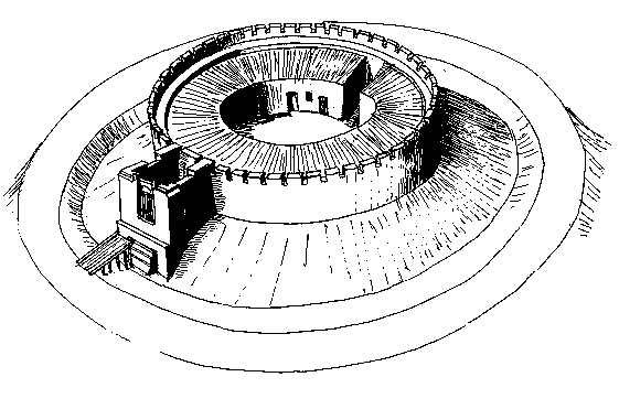
    Would this be evidence of a shell keep?
    shllkeep.gif


  • Closed Accounts Posts: 94 ✭✭KnapperHandy


    Hi Simon.d,

    Yes,I see no reason why they may not be remnants of a shell keep - it looks good to me!

    Have you seen any similar looking stones in the fosse below?If not,they may have been used in field boundary walls close by perhaps.

    If they post-date the Norman occupation of the motte,then I can't see what a stone structure on top may have been used for??


  • Closed Accounts Posts: 94 ✭✭KnapperHandy


    For those who may not be familiar with shell-keeps,I've attached a couple of images of one below.

    This is known as Wiston Castle and can be seen in Pembrokeshire,south Wales.


  • Registered Users Posts: 316 ✭✭Simon.d


    Hi Simon.d,

    Yes,I see no reason why they may not be remnants of a shell keep - it looks good to me!

    Have you seen any similar looking stones in the fosse below?If not,they may have been used in field boundary walls close by perhaps.

    If they post-date the Norman occupation of the motte,then I can't see what a stone structure on top may have been used for??

    I saw another stone close to the in situ cluster a couple of metres down the slope of the mound, that looks like it may have rolled down..


  • Closed Accounts Posts: 94 ✭✭KnapperHandy


    I was reading the link you attached in your earlier post relating to this motte where it states 'The flat topped mound is 10 metres in diameter at the top'.

    Most shell-keeps I'm led to believe were about 25 metres or more in diameter.Okay,it can be argued that we must allow for erosion of the mound over the centuries,but it still means if it was a shell-keep,it must have been significantly smaller than the norm.


  • Advertisement
  • Registered Users Posts: 316 ✭✭Simon.d


    I was reading the link you attached in your earlier post relating to this motte where it states 'The flat topped mound is 10 metres in diameter at the top'.

    Most shell-keeps I'm led to believe were about 25 metres or more in diameter.Okay,it can be argued that we must allow for erosion of the mound over the centuries,but it still means if it was a shell-keep,it must have been significantly smaller than the norm.

    Here's Wiston Keep that you referenced earlier.. It's quite comparable in scale methinks (compare keep size with 10m scale bar in bottom left of this bing map)


  • Closed Accounts Posts: 94 ✭✭KnapperHandy


    Just looking at the scale,the Wiston Castle keep would appear to be 15 metres in diameter.Yeah,I agree,it would be quite close in scale alright!


  • Closed Accounts Posts: 94 ✭✭KnapperHandy


    I'm sure you've checked this out yourself,but I was just looking at the record for this site in the 'Archaeological Inventory of Co.Waterford',published in 1999,and no mention is made of the remnants of a stone structure being visible on the motte then.Maybe,these stones have just been exposed due to erosion in recent times.


  • Registered Users Posts: 316 ✭✭Simon.d


    I'm sure you've checked this out yourself,but I was just looking at the record for this site in the 'Archaeological Inventory of Co.Waterford',published in 1999,and no mention is made of the remnants of a stone structure being visible on the motte then.Maybe,these stones have just been exposed due to erosion in recent times.

    There is no mention alright.. But it's hard to know how detailed that survey was at the same time.. I don't erosion would be to blame though, as the vegetation is quite heavy, which would keep it largely intact methinks, especially over such a short time-frame.. I must go back and see if there are any more stones along that perimeter...

    I've been doing a bit of research into the (potential) history of the site.. It lies within the parish of Lisnakill and there's a reference to a William de Eincourt in the early 1200s as being Lord of Incheth and Lisnekill .. His Daughter "Feya" apparently married Walter de Poer, Lord of Dunbrattin & Rathcormack and they had a son Benedict de Poer, who was shown to be in posession of Lisnakill (and Portally) in 1287 ..

    There's also the reference to a 1291 inquisition that took place in Lisnakill, that implies (to me anyhow) the site was of some importance..
    ER50QSG.png?1

    In c1330 there's a reference to it potentially being in possession of Gilbert de Pembroke (a probable explanation for the name of the town land : Pembrokestown) hKFzkp2.jpg?1


  • Closed Accounts Posts: 94 ✭✭KnapperHandy


    You're right,it's most likely the stones were overlooked during the original survey.I wonder would it be necessary to let the National Monuments Service know of your findings;it's most likely this was something hitherto unknown about this monument and can be added to the record for posterity.

    Your research is quite interesting indeed!I wonder is this Gilbert de Pembroke you mention,a descendant of Richard fitz Gilbert de Clare,the 2nd Earl of Pembroke,ie.Strongbow?


  • Closed Accounts Posts: 94 ✭✭KnapperHandy


    Your research is quite interesting indeed!I wonder is this Gilbert de Pembroke you mention,a descendant of Richard fitz Gilbert de Clare,the 2nd Earl of Pembroke,ie.Strongbow?[/QUOTE]

    I've since had a gander online to see if there's any possible ancestral link between Gilbert de Pembroke and Strongbow,but it appears there wasn't.

    To be honest,the Norman Conquest and indeed Norman family genealogies in Ireland isn't something I'm wholly familiar with.:o


  • Registered Users Posts: 316 ✭✭Simon.d


    I've since had a gander online to see if there's any possible ancestral link between Gilbert de Pembroke and Strongbow,but it appears there wasn't.

    To be honest,the Norman Conquest and indeed Norman family genealogies in Ireland isn't something I'm wholly familiar with.:o

    I wouldn't say there's a direct link.. But could be a relative of some sort.. Gilbert was a family name after all..

    Whoever he was he seemed a bit of a renegade, as there's a few mentions of him around Waterford, all regarding him getting into trouble.. i.e. the reference posted was regarding him holding land illegally in Lisnakill (at least that's my interpratation)..


  • Closed Accounts Posts: 94 ✭✭KnapperHandy


    Simon.d wrote: »
    I wouldn't say there's a direct link.. But could be a relative of some sort.. Gilbert was a family name after all..

    Whoever he was he seemed a bit of a renegade, as there's a few mentions of him around Waterford, all regarding him getting into trouble.. i.e. the reference posted was regarding him holding land illegally in Lisnakill (at least that's my interpratation)..

    Funny enough,I can't seem to find a mention of a 'de Pembroke' family anywhere online and when you google the family name,the 'de Clares,Earls of Pembroke' keep popping up,so yeah,there may be some tangible link somewhere along the line!

    By the way,there are two Norman mottes in my hometown and I'm not aware that either have or have had evidence of a shell-keep on top,
    but I might just take a closer look,you just never know?


  • Registered Users Posts: 1,696 ✭✭✭MoodeRator


    Could anyone tell me what these 3 might be please? Another Orions Belt?:confused:
    Four Mile House


  • Closed Accounts Posts: 94 ✭✭KnapperHandy


    Hi MoodeRator,

    I've just had a look on the National Monuments Service Database(see the link below):


    http://webgis.archaeology.ie/NationalMonuments/FlexViewer/.

    This link can be found on the Archaeology Forum Charter Thread here.

    I presume the townland in question is Ballinderry?If so,these are ringforts or raths.If you go to the link above and enter the relevant townland ie.Ballinderry,it will give you a detailed description of these monuments(they're recorded as R0035-012,R0035-011 and R0035-010001- on the database).

    Hope this helps!

    All the best.


  • Advertisement
  • Registered Users Posts: 1,696 ✭✭✭MoodeRator


    Thanks you are spot on! that link you provided is brilliant!


  • Closed Accounts Posts: 94 ✭✭KnapperHandy


    No problem MoodeRator!
    Glad I could help.
    All the best.


  • Registered Users Posts: 316 ✭✭Simon.d


    Interesting earthworks in Ballinlough, Co. Limerick.. http://binged.it/14v5wfV

    Remains of a Large Circular Enclosure in Clogher East, Co. Limerick.. http://binged.it/10EDZIa

    Assorted Earthworks in Clogher West, Co. Limerick http://binged.it/127QNo8


  • Registered Users Posts: 419 ✭✭bawn79


    Simon.d wrote: »
    Interesting earthworks in Ballinlough, Co. Limerick.. http://binged.it/14v5wfV

    Remains of a Large Circular Enclosure in Clogher East, Co. Limerick.. http://binged.it/10EDZIa

    Assorted Earthworks in Clogher West, Co. Limerick http://binged.it/127QNo8

    Regarding Clogher - was just reading online yesterday evening that theorized that Bruree was the 2nd Regia on Ptomley 2nd Century map of Ireland. (The other being Navan Fort / Emain Macha). Could be an explanation for some of those earthworks.

    http://www.askaboutireland.ie/reading-room/history-heritage/pages-in-history/an-mangaire-sugach-the-li/local-historical-events/city-between-the-bridges-/


  • Registered Users Posts: 316 ✭✭Simon.d


    bawn79 wrote: »
    Regarding Clogher - was just reading online yesterday evening that theorized that Bruree was the 2nd Regia on Ptomley 2nd Century map of Ireland. (The other being Navan Fort / Emain Macha). Could be an explanation for some of those earthworks.

    http://www.askaboutireland.ie/reading-room/history-heritage/pages-in-history/an-mangaire-sugach-the-li/local-historical-events/city-between-the-bridges-/

    That doesn't surprise me one bit.. Some fascinating markings on the landscape around there.. I only posted the ones above as they have no listing on the NMS register..

    But this one here is very interesting too, listed as an enclosure with no description.. ( LI039-001---- ) .. Deserves a bit more than that me thinks : http://binged.it/12z1VdA

    Another interesting one here.. Listed as a redundant record (LI039-145----) "This record is only referenced to 'ASIAP 2002' but I have been unable to find the relevant aerial photograph(s) so have made this a redundant record until the photograph is found- Denis Power 10th June 2011." Lots of lumps and bumps clearly visible around some circular feature: http://binged.it/12ze2av


  • Registered Users Posts: 419 ✭✭bawn79


    Simon.d wrote: »
    But this one here is very interesting too, listed as an enclosure with no description.. ( LI039-001---- ) .. Deserves a bit more than that me thinks : http://binged.it/12z1VdA

    ]

    God that one looks very interesting alright, remains of a henge I wonder? I might have a look at that at ground level when I get a chance.


  • Moderators, Science, Health & Environment Moderators Posts: 5,219 Mod ✭✭✭✭slowburner


    Simon.d wrote: »
    But this one here is very interesting too, listed as an enclosure with no description.. ( LI039-001---- ) .. Deserves a bit more than that me thinks : http://binged.it/12z1VdA
    This one looks like a manicured crop circle than a crop mark. It looks very neat and almost two dimensional.
    Does LI039-001 refer to the earthwork NNW by any chance?


  • Registered Users Posts: 316 ✭✭Simon.d


    slowburner wrote: »
    This one looks like a manicured crop circle than a crop mark. It looks very neat and almost two dimensional.
    Does LI039-001 refer to the earthwork NNW by any chance?

    It's extremely neat...

    But it features on the old Osi's so doubt it's a crop circle, also somewhat discernible on the osi aerial imagery.. :

    http://maps.osi.ie/publicviewer/#V1,552658,633291,7,9


  • Registered Users Posts: 316 ✭✭Simon.d


    bawn79 wrote: »
    God that one looks very interesting alright, remains of a henge I wonder? I might have a look at that at ground level when I get a chance.

    Another interesting one here if you're in the Area: http://binged.it/12Izryd

    Has a listing as earthworks with no description.. It's called Knocksouna, i.e. Hill of Samhain .. So sounds quite important, and likely to have been associated with the Regal history of Bruree going way back.. Seems to be associated with this individual/god :http://en.wikipedia.org/wiki/Mongfind


  • Advertisement
  • Registered Users Posts: 1,020 ✭✭✭Coles


    Aerial photography proves it's worth again.

    'World's oldest calendar' discovered in Scottish field, - BBC.
    The Warren Field site was first discovered as unusual crop marks spotted from the air by the Royal Commission on the Ancient and Historical Monuments of Scotland (RCAHMS).

    Dave Cowley, aerial survey projects manager at RCAHMS, said: "We have been taking photographs of the Scottish landscape for nearly 40 years, recording thousands of archaeological sites that would never have been detected from the ground.

    "Warren Field stands out as something special, however. It is remarkable to think that our aerial survey may have helped to find the place where time itself was invented."


Advertisement