Advertisement
If you have a new account but are having problems posting or verifying your account, please email us on hello@boards.ie for help. Thanks :)
Hello all! Please ensure that you are posting a new thread or question in the appropriate forum. The Feedback forum is overwhelmed with questions that are having to be moved elsewhere. If you need help to verify your account contact hello@boards.ie

M20 - Cork to Limerick [preferred route chosen; in design - phase 3]

Options
11213151718276

Comments

  • Registered Users Posts: 5,858 ✭✭✭Chris_5339762


    M20 Southern Section (Blarney - Mallow) and Cork NRR Phase 1 (Blarney - M8) will be built at the same time (eventually).

    As for the Blarney - N22 section of the NRR, god knows :(


  • Registered Users Posts: 2,720 ✭✭✭Bards


    [PR] €1bn Cork-Limerick motorway plan a step closer


    http://www.examiner.ie/home/euro1bn-cork-limerick-motorway-plan-a-step-closer-113078.html

    Thursday, February 25, 2010


    PLANS for one of the country’s longest and most expensive motorways linking Cork and Limerick will be lodged with An Bord Pleanála today.


    The €1 billion M20 project features:

    * 80 kilometres of dual divided motorway.

    * 6km of dual carriageway.

    * 45km of associated national, regional and local roads

    * A motorway service area at Lissard, near Rathduff.

    * 46 road bridges, eight river bridges and two railway bridges.

    * 33 structures for land or farm access, and 36 major culverts.

    Land values along the proposed route and construction costs have not been finalised. But the M3 from Clonee, west of Dublin, to Kells, which is 20km longer and due to open in July, will cost some €1bn.

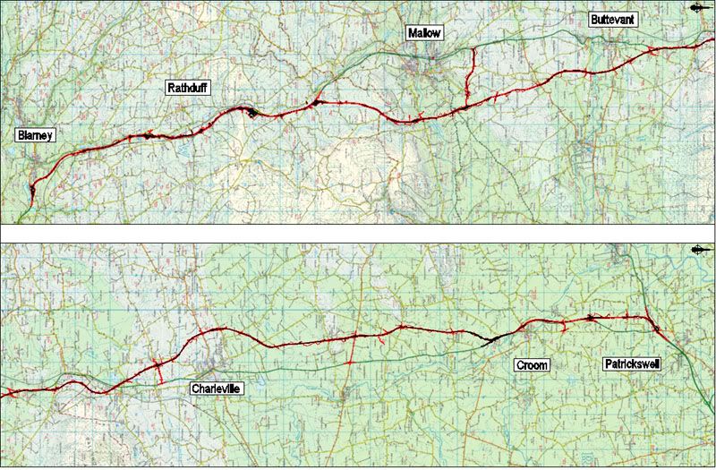
    The M20 will start at the existing Blarney junction and will remain online with the existing N20 to Mourneabbey. The proposed route will then veer east from the existing N20 passing east of Mallow and Buttevant. It will rejoin the existing N20 for about 2km at Velvetstown before again veering to the east.

    It will cross the N20 just south of Ballyhea, pass west of Charleville and continue west of the existing N20 until the Croom bypass.

    Most of the bypass will be reutilised as part of the new development and the new scheme will terminate near the existing junction at Attyflin, Co Limerick. An oral hearing on the proposed route will be held this summer and subject to funding, construction could start before the end of 2011. The project is being coordinated by Cork County Council and Limerick County Council, with the support of the National Roads Authority.

    When the corridor scheme is complete, Cork and Galway will be linked by some 200km of motorway.


  • Registered Users Posts: 1,284 ✭✭✭D.L.R.


    the M3 from Clonee, west of Dublin, to Kells, which is 20km longer and due to open in July, will cost some €1bn.

    Eh, the M20 will be almost DOUBLE the length of the M3. And people worry about the death of newsprint.. :rolleyes:


  • Banned (with Prison Access) Posts: 25,234 ✭✭✭✭Sponge Bob


    Maps CPO and EIS are all here

    http://www.corkrdo.ie/m20_cork_limerick_motorway_scheme_cpo.php

    You need an Autodesk DWF File Viewer app to read the maps in detail. The rest is in PDF format including some low res maps.

    You may even be go and meet "Isaac" at the hearing and give evidence against him :D


  • Registered Users Posts: 7,850 ✭✭✭munchkin_utd


    D.L.R. wrote: »
    Eh, the M20 will be almost DOUBLE the length of the M3. And people worry about the death of newsprint.. :rolleyes:
    the figures are right, on the M3 project you have:
    49km of motorway from Clonee to Kells (M3)
    10km of dual carriageway from Kells to Carnaross, North of Kells (N3)
    making 59km, indeed 21 km less than the N20, so 1km out but you'd let the paper away with that


  • Advertisement
  • Registered Users Posts: 441 ✭✭Joey Joe-Joe Jr


    the figures are right, on the M3 project you have:
    49km of motorway from Clonee to Kells (M3)
    10km of dual carriageway from Kells to Carnaross, North of Kells (N3)
    making 59km, indeed 21 km less than the N20, so 1km out but you'd let the paper away with that

    But the newspaper article states that the M3 is 20 km longer than the proposed M20.
    ...the M3 from Clonee, west of Dublin, to Kells, which is 20km longer...


  • Closed Accounts Posts: 6,093 ✭✭✭Amtmann


    My connexion speed is pathetic; can someone summarise the route of the M20 to Mallow? North of Blarney is an online upgrade envisaged, much like the Nenagh Bypass?

    (Or, better yet, upload some images from the EIS drawings.)


  • Banned (with Prison Access) Posts: 25,234 ✭✭✭✭Sponge Bob


    Online to within 5 miles of Mallow swings east offline and passes east of Mallow , there is a junction and an interconnect road NE of Mallow that goes about 1-2 miles west to the existing N20 north of the town. East until Charleville, crosses N20 and then remains offline remains west until it passes Croom and the Croom bypass is also online.

    No Adare Bypass or junction therewith is shown, there is no final route ( I think) and certainly no CPO and EIS for it.

    It appears a decision was made not to hold the remainder up for Adare.


  • Registered Users Posts: 577 ✭✭✭Typewriter


    I don't see a north ring road? :(

    Is that now not going ahead???


  • Banned (with Prison Access) Posts: 25,234 ✭✭✭✭Sponge Bob


    I don't see a north ring road? :(

    Neither do I, it could be because it is a separate EIS contract and may report separately ( and presently )

    See http://www.etenders.gov.ie/search/show/search_view.aspx?ID=APR082067


  • Advertisement
  • Closed Accounts Posts: 6,093 ✭✭✭Amtmann


    Hmm.
    * Scheme to be split into two, with the southern section likely starting first. Split most likely in Velvetstown area, where a temporary at-grade roundabout will be built.
    * Service area at Rathduff, which may be advanced as a separate scheme.
    * Nine grade-separated junctions at: Blarney (full), Rathduff (half), MSA (full), Mallow South (full), Mallow East (full), Charleville/Ballyhea (full), Bruree (full), Croom (full), Attyflin (full).
    * Lots of online upgrade.

    The last point will make this scheme protracted and messy, methinks.


  • Registered Users Posts: 1,639 ✭✭✭Zoney


    Sponge Bob wrote: »
    No Adare Bypass or junction therewith is shown, there is no final route ( I think) and certainly no CPO and EIS for it.

    It appears a decision was made not to hold the remainder up for Adare.

    Actually deposit map 43 shows land for a roundabout junction for Croom (north) with land for a spur to the west for Adare bypass, as was shown on earlier maps.

    Also deposit map 46 shows extinguishment of existing slips at the current N20 junction on the M20/N21 mainline, and possibly a messy new arrangement off that junction for the existing N21.


  • Banned (with Prison Access) Posts: 25,234 ✭✭✭✭Sponge Bob


    So they intend do the southern section first to a point somewhere between Buttevant and Charleville Furet ????

    Jebus, half that is online, very messy altogether. Best give that job to Roadbridge or Wills who don't hang about :D


  • Closed Accounts Posts: 6,093 ✭✭✭Amtmann


    Sponge Bob wrote: »
    So they intend do the southern section first to a point somewhere between Buttevant and Charleville Furet ????

    Jebus, half that is online, very messy altogether. Best give that job to Roadbridge or Wills who don't hang about :D

    Looks like it. See EIS part 1, p. 4.2 of 4.50

    I really hope Roadbridge gets this. Can you imagine how long it will take if it goes to Bam.

    EDIT, Velvetstown is a little north of Buttevant.


  • Closed Accounts Posts: 6,093 ✭✭✭Amtmann


    Attached.


  • Closed Accounts Posts: 6,093 ✭✭✭Amtmann


    Hate posting three posts back-to-back, but I think when the time comes we should have this thread as a pre-construction thread and have two separate ones for the two halves once they start construction. The M9 thread is a monstrosity now, and is very hard to follow casually. I don't think this thread should go down that path...


  • Banned (with Prison Access) Posts: 25,234 ✭✭✭✭Sponge Bob


    Furet wrote: »
    Attached.

    And in there on page 72 of 446 ( cannot copy it :( ) they say the development will be split at Velveststown and the southern bit from there will be done first.

    The MSA will be a third separate scheme.

    I suppose the northern bit will be held over until they complete the Adare EIS and CPO which has not been given to Jacobs Engineering that I can see ...or anybody else. Jacobs have the old style engineering consultancy contract in Adare since 2005.

    The NRR is mentioned on page 131 where they say "IF" the NRR is constructed at the same time ....not AS or WHILE , it has been decoupled from the M20 southern section to a certain extent...do read the whole page. But the NRR is a separate EIS and CPO to be prepared by Fehilly not Eptisa/Arup.

    If ye had any competent TDs in all of Limerick and Cork ye could get them to ask Dempsey questions in the Dáil

    1. When will the CPO and EIS for the NRR be published.
    2. Will the Bord Pleanala Hearing be conducted for

    a) M20 ( all)
    b) M20 ( all + NRR)
    c) M20 South ONLY
    d) M20 South AND NRR TOGETHER?

    and in what decade ????

    3. Will the NRR go to construction with the M20 Southern section Cork-Velvetstown
    4. Now that the northern M20 section has decoupled can he give a date when the PPP Tender willl be published for each of

    a) M20 south
    b) M20 North
    c) Adare :D
    d) Cork NRR

    ...you know, important stuff for Cork TD's like !!!!!


  • Closed Accounts Posts: 6,093 ✭✭✭Amtmann


    The North Ring is mentioned under the "Early Feasibility Studies" section from page 51/446 (specifically p. 53). In addition the possibility of a connection to the M8 at Mitchelstown is discussed and then dismissed.


  • Banned (with Prison Access) Posts: 25,234 ✭✭✭✭Sponge Bob


    Question 5. When will the EIS for Adare go to tender and when will the tender be awarded ???


  • Registered Users Posts: 1,639 ✭✭✭Zoney


    Is the southern section cheaper? If so, this may have more chance of going ahead, and with it built, to some extent it makes it unlikely the northern section will be permanently stalled even if it is held up (makes the state of the existing road all the more glaring if it has motorway north and south of it).


  • Advertisement
  • Closed Accounts Posts: 6,093 ✭✭✭Amtmann


    I'm still quite shocked at the thought of a rebuild of the existing N20 from Blarney to the southern outskirts of Mallow. That will be quite an undertaking indeed, especially from Rathduff to Mallow, where the amount of ribbon development, junctions and constraints in general is formidable.


  • Closed Accounts Posts: 6,093 ✭✭✭Amtmann


    In this map Velvetstown marks the cut-off point between the N and S sections of the proposed M20.

    N20N73M8.jpg

    It looks to me like the N73 is crying out to be linked to the M20 via a dead straight spur, no more than 8 or 9km long, that would remove the painful bend and dive in the N73's current alignment. Such a spur would bring the M20 much closer to Kildorrerey, Mitchelstown, and the M8.


  • Closed Accounts Posts: 10,025 ✭✭✭✭-Corkie-


    As furet said above about the new thread, i am livin west of mallow so when construction does commence i should be able to give regular updates and pictures. Roadbridge would be the ideal contractor allrite furet but anything would be better than bothar hibernian, i would have to go down there with a wheelbarrow and shovel to improve progress.:)


  • Registered Users Posts: 5,858 ✭✭✭Chris_5339762


    Heres a general map -

    m20a.jpg


  • Closed Accounts Posts: 6,093 ✭✭✭Amtmann


    Those DSW files are horrendous to work with.


  • Closed Accounts Posts: 3,010 ✭✭✭Tech3


    Furet wrote: »
    I'm still quite shocked at the thought of a rebuild of the existing N20 from Blarney to the southern outskirts of Mallow. That will be quite an undertaking indeed, especially from Rathduff to Mallow, where the amount of ribbon development, junctions and constraints in general is formidable.

    There is indeed but most of the road is very wide so online upgrade should not be so bad given the right contractor gets the job to carry out the work. The best part of it all will be easy to keep track of progress on the scheme from Mallow south. Is the 2+1 original section included in the online upgrade?

    A little off topic I think the N21 to south of Adare should be dual type 1. You cannot avoid the fact that 25,000 cars pass through the streets of that town every day which 2+2 wont handle of a bypass. Also the junction at Croom is not not good enough to cater those traffic numbers.


  • Closed Accounts Posts: 6,093 ✭✭✭Amtmann


    tech2 wrote: »
    There is indeed but most of the road is very wide so online upgrade should not be so bad given the right contractor gets the job to carry out the work. The best part of it all will be easy to keep track of progress on the scheme from Mallow south. Is the 2+1 original section included in the online upgrade?

    That's the crucial bit right there! ;)

    It seems that the 2+1 section will indeed be included in the online upgrade. Lots of at-grade junctions along there to contend with.


  • Registered Users Posts: 1,639 ✭✭✭Zoney


    Just heard a good question here. If this is to be motorway... what will be the "alternate route" between Mallow and Cork? There'll be no "old N road" if it's an online upgrade! The original Mallow-Cork road? Not much of an option I'd have thought, though I'm not too familiar with it. Obviously there'll be parallel access roads for local traffic, but I'm talking about any longer distance traffic that can't go on the motorway. OK, so that's pretty hypothetical given we're basically talking L drivers, tractors and 50cc scooters or what not, none of which are that likely to be long distance - but still.


  • Closed Accounts Posts: 6,093 ✭✭✭Amtmann


    Grounds for the planning board to reject the southern section, perhaps? The original road is actually medieval.


  • Advertisement
  • Closed Accounts Posts: 10,025 ✭✭✭✭-Corkie-


    Zoney wrote: »
    Just heard a good question here. If this is to be motorway... what will be the "alternate route" between Mallow and Cork? There'll be no "old N road" if it's an online upgrade! The original Mallow-Cork road? Not much of an option I'd have thought, though I'm not too familiar with it. Obviously there'll be parallel access roads for local traffic, but I'm talking about any longer distance traffic that can't go on the motorway. OK, so that's pretty hypothetical given we're basically talking L drivers, tractors and 50cc scooters or what not, none of which are that likely to be long distance - but still.


    Blarney to bweeng to mallow is only 1k longer than using the main road at the moment. It runs almost parallel to the west of the n20.


Advertisement