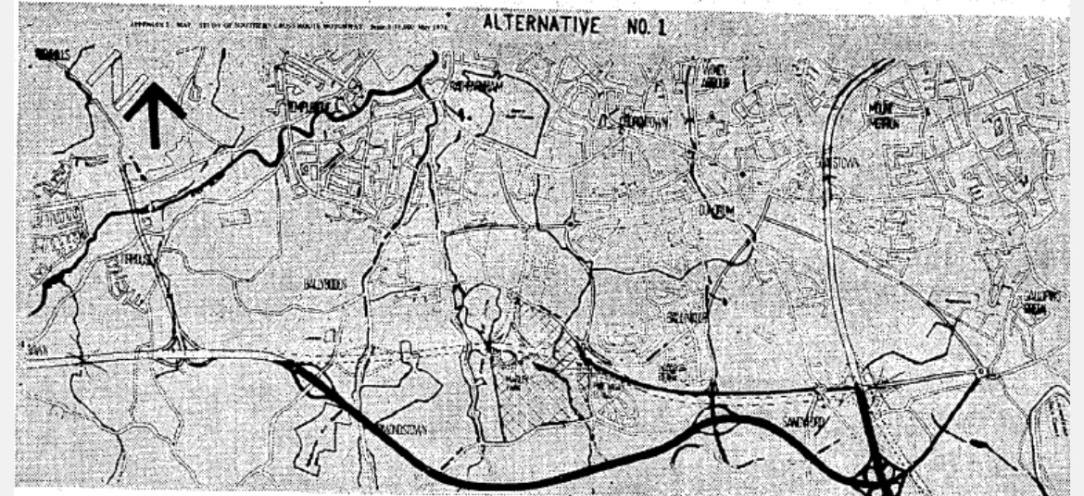
I came across some road infrastructure plans for Dublin which never happened, THANKFULLY. I thought it would be interesting to post here and see what other projects people can think of.
Correct, I provided a link above.
The original plan for the Dublin and Drogheda railway was to have the terminus on O’Connell Street where Clerys is now, but in the event it was put back to Amiens Street. Likewise the Kingstown railway was supposed to terminate opposite Pearse Street Garda station, but was instead located at Westland Row. Same for Harcourt Street, was supposed to be placed at the southwest corner of St. Stephen’s Green originally.
I missed that! .. Blacksod Lighthouse was the very place I heard about it. The tour is well worth doing if in the area.
Reminds me of another one from Co Mayo. The Cong Canal which was to link Loughs Corrib and Mask and would have provided navigation from towns in Mayo such as Ballinrobe all the way to Galway City. It was almost completed before it was abandoned by the OPW in 1854. There was an interesting book published on it last year, some details from which are included in the article below, including the reasons why it was abandoned ..
https://en.wikipedia.org/wiki/Cong_Canal
This is part of the work by the 1837 Railway Commissioners, whose railway maps are the granddaddy of infrastructure that never happened.
This is an extract of one thing that did not happen, perhaps it is now time for it, the Navan-Armagh railway line. This proposal was to be the Dublin-Belfast line and reflected the limitations of mid 19th century locomotives and their ability to climb between Newry and Dundalk. The sketch line runs a bit East of the later Kingscourt line, fairly close to the N2 between Carrickmacross and Castleblayney which is not far from the later GNR approach to Castleblayney, and then a line to Armagh somewhat to the West of the subsequent GNR line.
This was a proposal for an underground railway in Dublin as part of the 1971 Dublin Transport Study
@DublinCC
Here is a slightly better/different map of the 70's plan, interestingly they did not involve the Harcourt Street line, it was to be a guided bus way…
Pity that 70s Dart plan was not implemented. A lot of good stuff in there - that is 50 years ago.
It’s interesting to compare what we have today (or soon) with that plan. A lot of those corridors got reused and repurposed over the years, and today, the only missing link is the project to connect Heuston with the coastal line (that role was to be filled by DART Underground):
Harcourt Street only closed in 1958, ~15 years previous so there was a bias against admitting the mistake, to be fair in 1970 there was effectively nothing south of Dundrum, it was empty fields
But fields where the next wave of housing was going to be built. They weren't all going to drive in along Dundrum Road!
However, by and large they kept the alignment, so they were able to change their mind.
There's definitely something wrong with either me, the golf course designer or both of us.
But all I can see is an island full of penises.
Would this have been a quicker route to Belfast?
Was coming back to Dublin on the Enterprise (well, a NIR3000 class) from Belfast with the wife on Tuesday night, albeit stuck for over an hour because of a signal failure, but I believe without that it would’ve been about 2hrs10mins.
In the 1830s the criteria was that it was a flatter route to Belfast, early steam locomotives would have had real problems climbing out of Dundalk or Newry. The most direct route would have been close to the road, through Banbridge.
i might be mis remembering this but I'm sure I was at a talk where it said sligo railway station was built with access to the line to donegal which was never built. which is why it stops with a big wall at the end.
I don't believe the MGWR ever intended a line to Donegal, and it certainly wouldn't have gone through the end of Sligo station unless they intended to demolish the entire town centre to get across the river.
You’re wrong.
The intention was to continue the Enniskillen-Bundoran line to Sligo, permission was actually granted in 1862 and it would have gone through Sligo:
That isn't the MGWR.
I don't know what interchange they were planning to have, but out the back of the existing MGWR station would have been impractical, as the entire town is in the way.
In to the Sligo Quay branch and reverse would have been easier to but probably not cheaper cause of the size of the bridge required to cross the river/still functional then port.
Tunnel?
Under the river from the Quay branch? Might have worked. Don't think there were any under-water tunnels in Ireland pre Jack Lynch though?
Through the town? Station is already elevated over the ground on that side of it. A bridge and very selective demolition could have worked but I really doubt the MGWR was thinking of that.
Here is the specific act of parliament from 1862 describing the route
Doesn't go in to enough detail to figure out for sure, but I'd go for something like going out the Sligo Quay line.
Mentions joining at a "junction" in Rathedmond townland, which includes the station and the Sligo Quay branch junction.
Mentions a viaduct and a bridge over the Habour with a 40 foot opening span, which would suggest over the main harbour and not further down like going out the back would cause.
Big opening bridge over a harbour is a great bit of Never Built anyway
Also this proposal to build a railway from Malahide to Garristown, would’ve resulted in a station at Swords by the look of it:
Greenway west of athlone to Gort and then Galway can be added i guess.
A lesson in poor routing and giving into farmers.
The earliest proposal for a ring road around Dublin by Myles Wright in 1966:
Plan from 1978, a lot of recognisable stuff here but some proposals that either never happened or developed quite differently:
Original plan for the southern cross route of the M50 was for the road to go straight across Marlay Park, you can make out the faint dotted line goes directly east from what’s today J12, also the line of the proposed eastern bypass:
I am going back to before Just for Men became my friend but did Irish Rail via CIE want to reopen broadstone as a rail station around the time of the Design of the cross city Luas Or was that just CIE trying to stop the RPA?
Little of both...
They suggested it in lieu of opening Docklands for M3 Parkway services
Would they have sent sligo/Longford Services there aswell?
No, but they proposed Athlone to Broadstone via Moate, e.g. on what is now the Greenway. I presume new commuter services rather than putting Galway trains back to where they once served.
Broadstone station to reopen 70 years on – The Irish Times
The way the article is wrote it sounded like a done deal. So would they have followed the now luas route and tied in to the railway line behind St Attractas road?