Does this look bad this far out?
75mph(120kph) possible in coastal areas of Ulster.
It's a violent storm that didn't even exist a few hours ago but was accurately forecast a week ago and now it's just the exact track and intensity of the storm that is still open to change.
The weather models use ensembles where they run the model multiple times with probabilistic algorithms, and go with the forecast that matches the average outcome of those multiple simulations.
It's all probabilistic up until the moment it happens. That's the unavoidable nature of a chaotic system.
All the people who try to guess what model will verify with simple heuristics are having fun engaging with a hobby, but ultimately they're just speculating or making educated guesses.
Really the forecasts should be presented as probabilities, eg, at x location at x time there is a 30% chance of gusts between 50kph and 70kph, and 20% chance of gusts between 70 and 90kph etc
But those charts wouldn't be as fun to look at
Peak around 4 pm , not great as high tide is probably around 5pm so maybe some flooding then , tides are fairly strong at the moment
Agnes will be very close to buoy K2 around 0900 or 1000:
Off the top of my head, Ophelia gusted to 169kph at Fastnet lighthouse
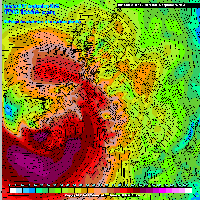
18Z UKMO HD. Strongest winds maybe on the Waterford Wexford coastline.
Love reading all the updates and memories. I’ve been in for all the weather events since 2008 or so under various usernames. The snow/ice lunacy was absolute madness. Had 13 leaks in the rental house that year and it took 6hrs to get from north Kildare to middle of Mayo. And through it all the lamppost watching and model chasing went on!
The calm before the storm... never hear that saying before?
Storm weakening slightly from 68knt to 62knot but will go through phases of strengthening and weakening before it hits us with gusts in excess of 60 knots tomorrow morning. First very outer winds have now reached the extremes of west Kerry. No longer calm in those areas. Around 10 to 15kph to start.
Coincides fairly well with Orange warnings, however the risks may be higher due to factors already mentioned.
Tiz true though. There isn't a wisp of wind out there. Come on Agnes. Show us what you got
Of course I did but it's amazing it's so dead calm out there, that's all I meant.
Joint Cyclone Center is a private amateur individual that just posts clickbait nonsense with no accreditations. It should never be posted here again. Also @Dazler97 those "categories" are pure amateur by a UK weather enthusiast, again with no accreditations. Though they were done for fun with no clickbait intentions compared to the former.
Ara lads what are the chances of schools/uni's/work being cancelled tomorrow?
None? :(
No way aww well that's a shame I feel stupid now ,thanks for letting me know though syran :)
Gradual increase through the morning but by 10 or 11am it will be very windy. 40 to 50kph sustained winds and gusts up to 90kph.
Starting to ease around 6pm, but still very windy.
Wont settle properly until late Thursday PM.
Its called "Joint" coz thats they do be smoking when they go online!
There's a storm coming
Took the decision to drive back from West Cork to Kilkenny tonight. Currently stopped to fill up on McDonalds 😁
Not at all, it looked very 'official' to me too. Not to mind.
Do you remember the storm in 1990? It was the first major storm that i can recall. What were the strength of the gusts for that inland? Some massive trees came down in it.
I think you're better off away from the South coast anyway. I'm in Kilkenny myself and expecting a good rattle here tomorrow.
I’m in Cork City but worth charging the various devices, particularly laptops, just in case.
January 5th 1991 had gusts over 100mph, around 107mph.
February 1990 was full of storms but not sure if any had any severe gusts.
https://www.met.ie/cms/assets/uploads/2017/08/Feb1990_storms.pdf
83 knots 5th Jan 1991. 96mph. I checked the Met Eireann site. A little less than I thought.
Really appreciate all the screen shots through the post. Weather especially the extremes are fascinating.
Stay safe.
Depends. The coastal counties of Munster and south Leinster may see upgrades to Red, in which case Schools and Colleges will be asked to remain closed. But for work places, its a private matter and will depend on safety tolerances for the specific work in question.
Certainly working at height, craning and construction lifting wouldn't be advisable tomorrow, likewise some farming and forestry activities and some transport firms may advise shelter for peak hours.
For many, it'll be a take it as it comes situation, but I'll bet many will work at home rather than commute and outdoor tasks that can be postponed will be for a day or two.
20:15 utc
00:45
00:45 Airmass


![Photo of [Deleted User]](https://w8.vanillicon.com/v2/82d003fd2122b93acc890998f11fd913.svg)




![Photo of [Deleted User]](https://wb.vanillicon.com/v2/b1aba361f5b77a8017be035a0d4fc285.svg)


