Advertisement
If you have a new account but are having problems posting or verifying your account, please email us on hello@boards.ie for help. Thanks :)
Hello all! Please ensure that you are posting a new thread or question in the appropriate forum. The Feedback forum is overwhelmed with questions that are having to be moved elsewhere. If you need help to verify your account contact hello@boards.ie
Hi all! We have been experiencing an issue on site where threads have been missing the latest postings. The platform host Vanilla are working on this issue. A workaround that has been used by some is to navigate back from 1 to 10+ pages to re-sync the thread and this will then show the latest posts. Thanks, Mike.
Hi there,
There is an issue with role permissions that is being worked on at the moment.
If you are having trouble with access or permissions on regional forums please post here to get access: https://www.boards.ie/discussion/2058365403/you-do-not-have-permission-for-that#latest

N25/N30 - New Ross Bypass [open to traffic]

1202123252657

Comments

  • Registered Users, Registered Users 2 Posts: 3,977 ✭✭✭NewbridgeIR


    josip wrote: »
    The sides have grown in a lot in fairness.
    The old white line can still be seen in a few places

    https://goo.gl/maps/n6MDfSDRk2U2

    Any HGVs, or lorries as they were called back then, going under the county road bridge leaned on the horn for a good 10 seconds while they swung wide to go under the centre of the bridge. Great entertainment watching it from above on the railway, especially when a car from the other side didn't hear/heed the horn.

    https://goo.gl/maps/XGg9KoUhpr92

    At that time, boatloads of Japanese cars used to land in Ross, perhaps because of the strike at Waterford port.
    Anyways, the car transports heading south couldn't fit under the bridges. So they had to go the back road.
    If you thought the pink rock was bad...

    https://goo.gl/maps/hv3Vf436YRp


    I remember a fatal accident at the railway bridge c.1990/91. Coming back from Waterford RTC to New Ross. Bus Eireann and car. Awful.


  • Registered Users, Registered Users 2 Posts: 19,480 ✭✭✭✭road_high


    I remember a fatal accident at the railway bridge c.1990/91. Coming back from Waterford RTC to New Ross. Bus Eireann and car. Awful.

    The railway bridges on the old N9 were similar design though not quite as narrow and low as that one I’d say


  • Registered Users Posts: 667 ✭✭✭BelfastVanMan


    road_high wrote: »
    I remember a fatal accident at the railway bridge c.1990/91. Coming back from Waterford RTC to New Ross. Bus Eireann and car. Awful.

    The railway bridges on the old N9 were similar design though not quite as narrow and low as that one I’d say

    The one at Smithstown on the old N9 is a particularly bad one, from memory.


  • Registered Users, Registered Users 2 Posts: 19,480 ✭✭✭✭road_high


    The one at Smithstown on the old N9 is a particularly bad one, from memory.

    I don’t know the exact address but there were two between Ballyhale and Mullinavat (one was Knockmoylan?). I was only a chap but I vaguely remember they knocked the arch off at least one of them to make it easier for traffic to flow under- “Oncoming traffic in Centre of the road” were perhaps unique on a N primary route! The bends swept into them at 45 degree angles which made them lethal.
    There was also a low enough narrow bridge at Thomastown and also before Waterford but they were on straight. What an awful bloody road that was! As recent as 2010 that was the main road. Hard to believe


  • Registered Users Posts: 667 ✭✭✭BelfastVanMan


    road_high wrote: »
    The one at Smithstown on the old N9 is a particularly bad one, from memory.

    I don’t know the exact address but there were two between Ballyhale and Mullinavat (one was Knockmoylan?). I was only a chap but I vaguely remember they knocked the arch off at least one of them to make it easier for traffic to flow under- “Oncoming traffic in Centre of the road” were perhaps unique on a N primary route! The bends swept into them at 45 degree angles which made them lethal.
    There was also a low enough narrow bridge at Thomastown and also before Waterford but they were on straight. What an awful bloody road that was! As recent as 2010 that was the main road. Hard to believe

    I know...less than a decade ago...madness.

    The M9 is literally 2 centuries ahead of the R448.


  • Closed Accounts Posts: 40,061 ✭✭✭✭Harry Palmr


    The primary roads to and around the south east were appalling, some of them are still in need of significant investment - New Ross to Enniscorthy springs to mind and the N24 of course.

    The N9/R448 at Dungarvan (the other one) had a sharp right turn at the bottom of a long slope - the corner of a building (pub? unused now) at the junction got taken out at least once.

    https://goo.gl/maps/aQ1k5xTaqhm

    (do a rotation and you'll see 3 HGV's converging in this 2009 image)


  • Moderators, Entertainment Moderators, Science, Health & Environment Moderators Posts: 14,462 Mod ✭✭✭✭marno21


    road_high wrote: »
    I don’t know the exact address but there were two between Ballyhale and Mullinavat (one was Knockmoylan?). I was only a chap but I vaguely remember they knocked the arch off at least one of them to make it easier for traffic to flow under- “Oncoming traffic in Centre of the road” were perhaps unique on a N primary route! The bends swept into them at 45 degree angles which made them lethal.
    There was also a low enough narrow bridge at Thomastown and also before Waterford but they were on straight. What an awful bloody road that was! As recent as 2010 that was the main road. Hard to believe

    There's still an "oncoming traffic in middle of road" sign on the N24 north west of Cahir. These days whilst we are getting limited numbers of road projects built, to say they are transformative is an understatement.


  • Registered Users Posts: 1,162 ✭✭✭jelutong


    Frostybrew wrote: »
    Slightly off topic question, was the Pink Rock road originally part of the N25 back in the late 1970s and 80s? I travelled the road back in 1982 on the way to the ferry and remember it being a narrow enough winding road that you from which you could see the Barrow. I know that a new stretch of road was constructed in this area in the late 80s or 90s.

    Also, the road passed through Ferrybank, Milepost and Slieverue villages. Rocketts pub in the Milepost had a few narrow shaves over the years.


  • Registered Users, Registered Users 2 Posts: 19,480 ✭✭✭✭road_high


    Any one a 70s or early 80s detailed road map of Ireland? Be fascinating to see these old routes on maps


  • Advertisement
  • Closed Accounts Posts: 9,764 ✭✭✭my3cents


    road_high wrote: »
    Any one a 70s or early 80s detailed road map of Ireland? Be fascinating to see these old routes on maps

    http://map.geohive.ie/mapviewer.html and try the historic maps. Edit> You can open more than one map and superimpose one them on each other.


  • Registered Users Posts: 397 ✭✭Geogregor


    my3cents wrote: »
    http://map.geohive.ie/mapviewer.html and try the historic maps. Edit> You can open more than one map and superimpose one them on each other.

    What a brilliant website, I can spend hours on it :)


  • Registered Users Posts: 4,321 ✭✭✭m17


    The barrow crossing 12/02/19 (pic engineers ireland )
    mzL6Dfu.jpg


  • Registered Users Posts: 4,321 ✭✭✭m17


    The barrow crossing 13/02/19 (pic niall Roche twitter )
    uXcQs7G.jpg


  • Registered Users Posts: 4,321 ✭✭✭m17


    Bridge construction January 19
    bcs7Mad.jpg


  • Registered Users Posts: 4,563 ✭✭✭eagerv


    2100Hrs Tonight.
    The old Pink Rock road is open again...


    The road had become overgrown, it has now been cleaned up a bit.


    YR8Xq0k.jpg


    Io0kBO5.jpg


  • Advertisement
  • Registered Users, Registered Users 2 Posts: 410 ✭✭topnotch


    road_high wrote: »
    Any one a 70s or early 80s detailed road map of Ireland? Be fascinating to see these old routes on maps

    Took a quick snap of the old 1/2 inch to 1 mile South Wexford map there for ya. (1986)


  • Registered Users, Registered Users 2 Posts: 5,577 ✭✭✭swoofer


    any updates on the opening of this by pass, want to book uk trip asap?


  • Registered Users, Registered Users 2 Posts: 2,326 ✭✭✭alta stare


    swoofer wrote: »
    any updates on the opening of this by pass, want to book uk trip asap?

    Wexford CC and BAM say summer and rumours are it is behind and it will be November. From the progress i see when i pass by it looks like it is on schedule so who knows.

    Not being smart but do you need it to be open to book a trip?


  • Registered Users, Registered Users 2 Posts: 5,577 ✭✭✭swoofer


    yes, I want to by pass new ross forever, spent too long in queues!!


  • Registered Users, Registered Users 2 Posts: 2,326 ✭✭✭alta stare


    swoofer wrote: »
    yes, I want to by pass new ross forever, spent too long in queues!!

    Yeah it is a pain alright :D Mornings are fine its between half 5 and half 6 going in to New Ross from the Waterford side which is a pita.


  • Advertisement
  • Registered Users Posts: 1,162 ✭✭✭jelutong


    Waterford side?


  • Registered Users, Registered Users 2 Posts: 2,326 ✭✭✭alta stare


    jelutong wrote: »
    Waterford side?

    Coming from Waterford direction. I forgot to add the evening part to those times.


  • Moderators, Sports Moderators Posts: 12,208 Mod ✭✭✭✭Cookiemunster


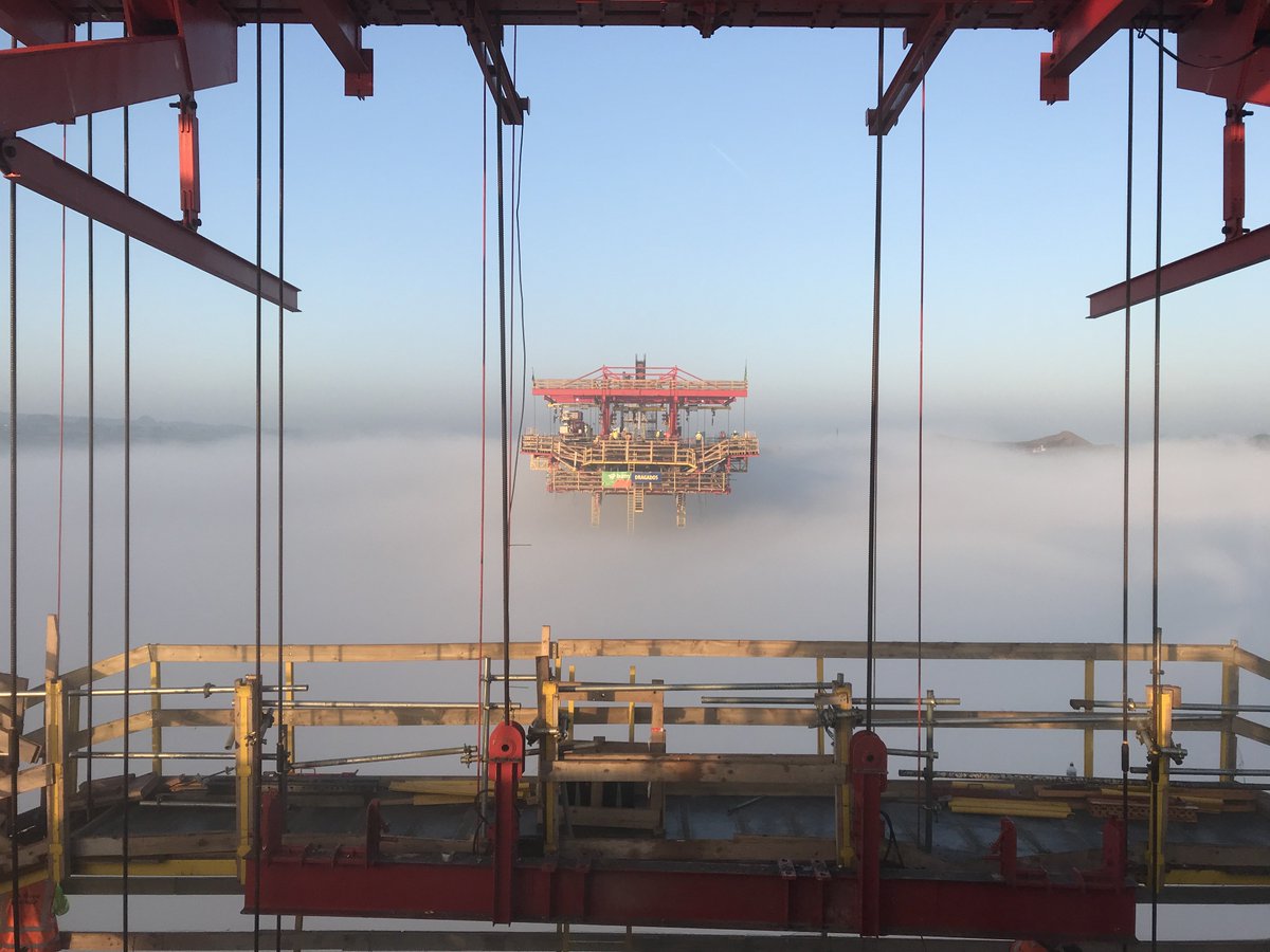
    Some cool pics in the fog posted on twitter by BAM

    Pier Three rising out of the mist - a thing of beauty, a joy to behold. #newrossbypass #n25nrjv @BAMIrl_ @BAMPPP

    D0a66xqXgAE7C0K.jpg

    D0a66wwX4AAuZK5.jpg


  • Registered Users, Registered Users 2 Posts: 1,973 ✭✭✭Deise Vu


    ^^^^
    That's worthy of the cool pics thread! The second photo is amazing. I have no head for heights, If I had to descend that ladder my imagination would be telling me the bottom half could be missing!


  • Registered Users, Registered Users 2 Posts: 6,893 ✭✭✭allthedoyles


    The eagerly anticipated New Ross Bridge and N25 Bypass will open at a yet to be determined date in 2020, rather than this summer, as had been previously anticipated.
    The news, disclosed to South Kilkenny Councillors at the February meeting of the Piltown Municipal District, was not greeted with any palpable sense of disappointment on members’ behalves.

    As late as last September, Councillors had been told that the project was due to open by June of this year.


    http://www.munster-express.ie/business/new-ross-bridge-to-open-in-2020/


    Its going to be 2020 as I always suspected .


  • Registered Users, Registered Users 2 Posts: 2,326 ✭✭✭alta stare


    That is disappointing if true.


  • Registered Users, Registered Users 2 Posts: 3,289 ✭✭✭Azatadine


    No surprise though is it? It's been pretty well flagged. I hope it's early 2020 but if they are not giving a date, it may well be a long way off still.


  • Registered Users, Registered Users 2 Posts: 14,170 ✭✭✭✭josip


    Presumably that article is by and large a cut and paste press release from BAM with little if no journalistic input?
    Some of the statements are completely contradictory.

    "will open at a yet to be determined date in 2020"

    "Councillors had been told that the project was due to open by June of this year."

    "Progress ... has proceeded on schedule"


  • Registered Users, Registered Users 2 Posts: 10,758 ✭✭✭✭Jamie2k9


    Oh dear Leo or just about any TD will have no photo opportunity before an election!


  • Moderators, Science, Health & Environment Moderators Posts: 19,873 Mod ✭✭✭✭Sam Russell


    Jamie2k9 wrote: »
    Oh dear Leo or just about any TD will have no photo opportunity before an election!

    I think standing on the edge of the part completed bridge looking into the Barrow would make a tremendous photo op.


  • Advertisement
  • Registered Users Posts: 4,321 ✭✭✭m17


    The barrow crossing 28/02/19 (pic endo delaney)
    2f60dv2.jpg


  • Registered Users, Registered Users 2 Posts: 69,588 ✭✭✭✭L1011


    Enniscorthy is the same constituency - they should do photo op wise


  • Registered Users Posts: 4,321 ✭✭✭m17


    The barrow crossing 07/03/19 (pic fb)
    j7cd5QW.jpg


  • Registered Users, Registered Users 2 Posts: 3,289 ✭✭✭Azatadine


    I wish those sections would connect! Then I'll know we are getting close!


  • Registered Users Posts: 1,162 ✭✭✭jelutong


    So would BAM!


  • Registered Users Posts: 4,321 ✭✭✭m17


    The barrow crossing 27/02/19 (pic stan prucha)
    MoyfGw3.jpg


  • Registered Users Posts: 4,321 ✭✭✭m17


    The barrow crossing 27/02/19 (pics stan prucha)
    DnGolhO.jpg

    TpD2iet.jpg


    THajFVf.jpg


  • Registered Users, Registered Users 2 Posts: 14,170 ✭✭✭✭josip


    lRsYhIq.jpg


    fO711cr.jpg


  • Registered Users, Registered Users 2 Posts: 3,289 ✭✭✭Azatadine


    I know nothing about construction but was wondering if those two missing sections get 'dropped in' or do the sections need to be built out and meet each other?


  • Advertisement
  • Registered Users, Registered Users 2 Posts: 14,170 ✭✭✭✭josip


    Azatadine wrote: »
    I know nothing about construction but was wondering if those two missing sections get 'dropped in' or do the sections need to be built out and meet each other?


    They get built out using travellers.
    There was a movie posted earlier but I can't find it.
    BAM Slideset has some info.
    https://www.waterfordchamber.ie/images/Declan-Roche-BAM.pdf


  • Registered Users, Registered Users 2 Posts: 6,893 ✭✭✭allthedoyles


    The gap appears to be closing slowly but surely


  • Registered Users, Registered Users 2 Posts: 1,473 ✭✭✭vickers209


    Few pics from facebook
    53373523_2459543440933279_7767297743197831168_n.jpg?_nc_cat=103&_nc_ht=scontent-dub4-1.xx&oh=503f37457033565d8bdf199ac73e417c&oe=5D13101B

    53160213_2459543450933278_5610188257443708928_n.jpg?_nc_cat=106&_nc_ht=scontent-dub4-1.xx&oh=cabdef6d315d1febd894bd143b91bf1c&oe=5D08A397

    53354607_2459543457599944_2005969874370691072_n.jpg?_nc_cat=108&_nc_ht=scontent-dub4-1.xx&oh=876d1288564b2b5e952f94ab61491ee9&oe=5D181A73

    53614354_2459543530933270_6924521801334652928_n.jpg?_nc_cat=108&_nc_ht=scontent-dub4-1.xx&oh=c6e31c8338077bb7691b7db97d358945&oe=5D15336B

    53859537_2461871864033770_6259303157562605568_n.jpg?_nc_cat=105&_nc_ht=scontent-dub4-1.xx&oh=85b3aefc7c70972d2715ea036509748c&oe=5D142270


  • Registered Users, Registered Users 2 Posts: 14,170 ✭✭✭✭josip


    ^^^^^ Have those photos been given the John Hinde treatment?


  • Registered Users, Registered Users 2 Posts: 5,967 ✭✭✭Chris_5339762


    I had a sudden thought. Is there, by volume, more concrete in this 900m long bridge than in all of the buildings in the town it is bypassing?


  • Registered Users Posts: 15 Kirbstone


    Concrete volume comparison is academic & not relevant. Latest pics very good and informative. Progress may seem slow, but on quite a complex project as this, haste is not an option.
    We've been waiting for this bridge for a lifetime and a few months delay is nothing. It's shaping up to be a great deal more impressive 'in the flesh' than the photomontages.


  • Advertisement
  • Registered Users Posts: 4,321 ✭✭✭m17


    The barrow crossing 07/03/19 (pic fb)
    Apa1Yjs.jpg


  • Registered Users, Registered Users 2 Posts: 5,081 ✭✭✭fricatus


    I had a sudden thought. Is there, by volume, more concrete in this 900m long bridge than in all of the buildings in the town it is bypassing?
    Kirbstone wrote: »
    Concrete volume comparison is academic & not relevant.

    Of course it's academic and irrelevant, but it's nevertheless an interesting question by way of diversion.

    I have no grounds whatsoever to back this up but I would bet that there's a lot more concrete in the town than in the bridge. New Ross is not huge, but it's not a little village either. I'd be interested to see calculations from someone with the relevant knowledge!


  • Registered Users, Registered Users 2 Posts: 14,170 ✭✭✭✭josip


    I'll have a wild stab at New Ross, but I have no qualifications in the area :D
    Population of 8,000 people and with an average of 2.7 per house = just under 3,000 houses.

    I've seen a figure of 50 cubic metres of concrete per 'average' house.
    So 150,000 cubic metres for housing.
    And then I'd triple that for all the other stuff, shops, schools, halls, concrete streets, Hanrahan bridge, piping, the mushroom, etc.
    So 450,000 cubic metres in the town by my guess.


    How much is in the bridge?


  • Registered Users Posts: 4,321 ✭✭✭m17


    josip wrote: »
    I'll have a wild stab at New Ross, but I have no qualifications in the area :D
    Population of 8,000 people and with an average of 2.7 per house = just under 3,000 houses.

    I've seen a figure of 50 cubic metres of concrete per 'average' house.
    So 150,000 cubic metres for housing.
    And then I'd triple that for all the other stuff, shops, schools, halls, concrete streets, Hanrahan bridge, piping, the mushroom, etc.
    So 450,000 cubic metres in the town by my guess.


    How much is in the bridge?

    27,000 cubic metres


  • Registered Users, Registered Users 2 Posts: 855 ✭✭✭corm500


    I assume this will be the longest bridge in Ireland north and south, but where does it sit in the scheme of things if you were to include Britain?


  • Advertisement
Advertisement