Advertisement
If you have a new account but are having problems posting or verifying your account, please email us on hello@boards.ie for help. Thanks :)
Hello all! Please ensure that you are posting a new thread or question in the appropriate forum. The Feedback forum is overwhelmed with questions that are having to be moved elsewhere. If you need help to verify your account contact hello@boards.ie
The Sudden Stratospheric Warming 2011/2012
Options
Comments
-
Winter-11-12-arctic-oscillation
by TQ from newxsfc
The Arctic Oscillation (AO) has been positive 99 out of 108 days since 01 SEPT however...there are a few signs suggesting a change for the better may be afoot.
The first sign points to a weakening polar vortex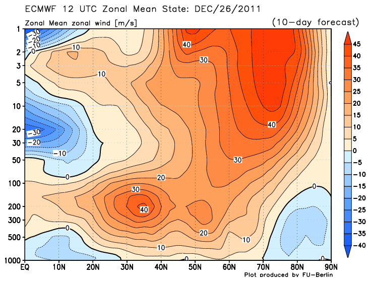
The wind speeds are currently running ~100 kt in the last few millibars @40°;N and are forecast to weaken to ~45 kts at D+10. Also note the development of deep easterly flow below 100 mb suggesting the presence of a hi-latitude anticyclone and an strengthening sub-tropical jet. A hi-latitude HIGH would flip the sign of the AO to negative.
The second sign points to a warming stratosphere over the 90°N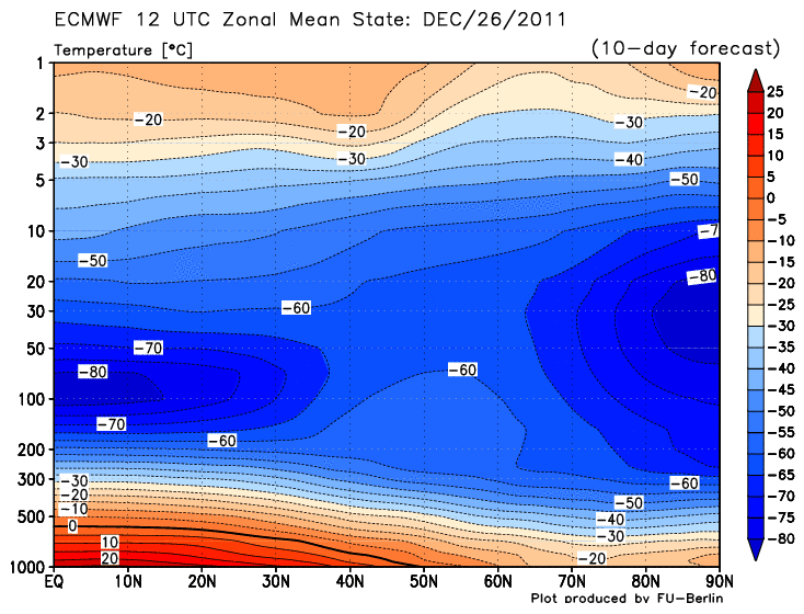
If the warming persists and works its way down...this would build and anti-cyclone aloft which could propagate toward the surface and create of re-enforce a negative AO.
The last sign points toward a bloated chunk of cold air from Siberia migrating into eastern North America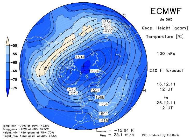
Note the 'W' in the light orange area. This frigid feature propagated east from Siberia. It indicates a warm stratosphere and low geo-potential heights in the troposphere.
The state of the AO through the years (1950 - 2011) at fifteen days into the meteorological winter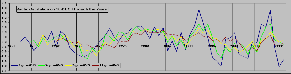 0
0 -
Just wondering what a stratospheric warming event is? Mt used the words in his forecast this morning. Apologies if it has already been discussed0
-
-
We really need to see warming at the 30hpa level of the Stratosphere to increase the chance of warming affecting the Troposphere. At the current level it may not be enough to percolate down to affect it.
What we're currently getting is a downwelling event caused by something known as rossby waves. A SSW seems to occurs from upwelling - this is an event- usually Trophosphoric blocking - in the troposphere causing the Stratosphere to warm up. These happen quickly and the effects are quicker.
The questions to be resolved are: can this downwelling in turn cause an upwelling event? or will the downwelling be sufficient in itself to change the current NH pattern? if so it will probably take longer for us to see the effects...
a real cause for concern is that in the past two years the ECM extended range output correctly flagged the northern blocking, however
the ECM longer range output shows no sign of northern blocking even through January and beyond. we must hope that they've overlooked something this time.0 -
Hello.
I have just registered on the forum, but I am reading this topic for a while now. I would really like to thank you all for this great topic, which is very educational. I am familiar with classic meteorology, but the "Upper meteorology" is relatively new to me.
I haven't read all the links about the SSW in the first post, since my job is kinda limiting my free time for meteorology, but I am making slow progress.")
Now, down to business:
I can say, that even with my little knowledge about SSW, I can spot the signals in models, when I see them. Or that's just me.
I was kinda surprised by the ECM 20.12 12z run.
Here are some graphics, that clearly speak for themselves.
Current status @30hpa
The 10-day forecasts are very interesting. At least for me.


Things are on the move, as I see them. Maybe I am not looking wide enough, but I think that this certainly is worth monitoring.
I apologise if I have posted too many graphics.
Looking forward to hear some thoughts from you, about this latest forecasts.
Best regards,
Andrew.
P.s.: I live in Slovenia, Central Europe, so maybe my time for posting will be a bit different that many of yours. And I apologise for the spelling, since English is not my mother language. 0 -
Advertisement
-
Welcome, Andrew. Yes I find the subject fascinating myself and things are heating up, lol. Look to be serious Polar Vortex disruption at the top level (1hpa) as the warming penetrates into the core of the vortex. Winds are forecast to turn easterly up there as a result and look as though they will propagate somewhat, as can be seen in forecasted warming in levels below that. Question is, will it be enough to cause a SSW. Well it's certainly a start.

 0
0 -
Great posts guys. Makes for interesting reading while the weather we are currently having is about as boring and uninteresting as possible for this time of year.0
-
Looking promising...touch wood.
 0
0 -
-
-
Advertisement
-
-
Hi Su, in layman's terms what is this telling us?
D
Watching the evolution of that pattern, the polar vortex (blue) is becoming overwhelmed by the warmer temperatures, which is setting up and easterly flow between the two over Greenland and northern Canada. This process looks like possibly continuing as far as splitting the whole pattern in a figure-of-eight, with two distinct curculations - one cyclonic and another anticyclonic. This can set up blocking in the lower atmosphere later on, which could bring us an easterly or northeasterly. It all depends on where the blocking high sets up camp.
As this is the far reaches of the GFS it could all go belly up, but is just a promising sign if you like cold in January (which is around 99.999% of people here!).0 -
Thanks for the clarification Su
D0 -
Join Date:Posts: 6780
This mornings update - there is a lot to take in.
Firstly, we are about to see a large wave 1 induced warming that is going to disrupt the stratosphere for the first time this winter. We have been waiting a long time to see the below average cold conditions driving the strong polar vortex be threatened.
So this wave breaking into the upper stratosphere is large enough to give a forecast reversal of mean zonal mean winds at the upper levels of the stratosphere. The vortex though is not forecast to break up completely. It is close and probably on a knife edge, but I suspect that we will need another wave break and subsequent warming to break the vortex.
Moving down the warming does propagate down to the 10 hPa level and propagation is supported by a poleward EP flux. However it is insufficient to give us a SSW currently - so still no SSW.
However, what is forecast to occur is very encouraging and will have some effects on the vortex positioning in the troposphere. In fact I suspect that a Pacific based ridge will build which will be a preconditioning building block to an eventual SSW. We are most certainly heading in the right direction, but frustratingly for cold lovers more patience required.0 -
Join Date:Posts: 6780
Current Heat Flux
Projected
10hpa Height / Temps
Zonal Wind reversal0 -
I would just like to point out the CFS v.2, weekly forecast.
This if for week 3. An Atlantic and Pacific blocking. To me, this looks promising.
Best regards.0 -
Nothing much happening with the polar vortex for the next 10 days at least. Holding strong.
Analysis (00Z 29th December)
T+5 days
T+10 days
0 -
Interesting events to follow indeed.
I've been looking at University of Berlin data (http://wekuw.met.fu-berlin.de/~Aktuell/strat-www/wdiag/diag.php?alert=1&lng=eng) and though I kind of understand the first table (geopotentials and temperatures) I'm not sure about how to interpret the third table (zonal mean sections NH), especially heat flux and momentum flux. A tricky one too is the physical meaning of Eliassen-Palm-Vector.
Any pointer is very welcome.
Best wishes and Happy New Year,
Stephane0 -
I came across this from an Italian website so here it is translated,gives some good info in helping to understand. Excuse some sentences that are difficult to understand because of dodgy translation.
The QBO positive in conjunction with the low solar activity leads to a Stratospheric Polar Vortex ( VPS) is completely blocked, due to the semi-block full of "Brewer Dobson Circulation" that stratospheric level, is a real current hemispherical sundial can connect with the polar equatorial regions. In short, when the BDC is very weak, the VPS is very strong and cold as well as affected by stratospheric zonal wind very intense. Thus the entire structure of the polar vortex (VP) is very compact, with very few opportunities to exchange major meridians (Europe swept by the flow of warm ocean zonal matrix). In such a context, in fact, the large planetary waves, whose propagation is prerequisite for the cold air down from high to medium-low latitudes, enter into serious crisis. In other words, because of the high-speed stratospheric zonal, the heat flows from the array of tropical troposphere to the stratosphere polar penetrate up through the propagation of Rossby waves, are strongly divergent.
A similar situation is greatly aggravated by Nina moderate / strong central in nature. The strong trade winds, related to the Walker circulation that blow constantly on the ground over the years affected by the phenomenon of the Nina, potently inhibit the development of the Convention on much of the deep Pacific, being the largest ocean on the planet, turns out to be crucial for As regards the complaints against the VP. The reduction of air deep concern to the Convention has 2 effects:
1) further reduction of the strength of the BDC that much depends on the convective Pacific and in particular the amount of water vapor which, through the tropopause, the stratosphere Equatorial penetrate;
2) reduction of heat that flows from the troposphere into the stratosphere polar penetrate through the "breakthrough" in the layer of Rossby waves. Said terms "playful", the tropical heat of the Convention is a fuel for the formation of large, long waves can break into the stratosphere.
The situation described so far is "photographed" by some key images. First of all I report an image, captured by the satellite OMI-AURA, representing the amount of ozone in the polar stratosphere in early December. In this regard, remember that ozone transport from equatorial latitudes (where it originates) to the polar is related to the intensity of the BDC. Therefore the amount of ozone in the VPS is a good index to measure the strength of the BDC.
You can easily see the ozone hole just above the North Pole.
Secondly carry the image from ECMWF carriers on the EP-FLUX. In two words, remember that these vectors represent the amount of heat fluxes and momentum from the troposphere to penetrate the polar stratosphere. Therefore, the longer vectors indicate a good propagation and vertical flow of heat from the trope of the layer (good wave propagation).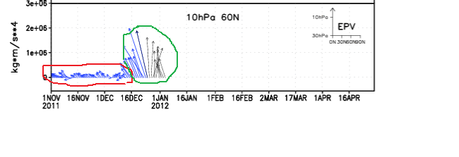
You will notice that until mid-December (red circle) patterns were completely different, a symptom of a VPS in great shape. Precisely in this period were reached in the polar stratosphere temperatures very low, near-record. In the second half of the month but something has changed since the first heat fluxes have been able to penetrate in part into the stratosphere (green circle). This forcing, started as told in the middle of the month and due in large part to the action of the continuous wave 1 (wave-Pacific), will in the coming days to less warming of the first season.
As I have repeatedly pointed out in comments made in the weather , the disorder is not at all associated with a dynamic thrust of the wave 1 (elevation of the Aleutian hp), but to a particular location of the lower middle VPS that has allowed the vortex semi-permanent Aleutian taking a particularly favorable position. Specifically, the continuing dynamic action induced by the tropo-wave 3 (Asian wave) led the Polar Vortex in the lower stratosphere, to assume a configuration with a major axis ellitticizzata highly favorable (Canada-Eastern Siberia). This location has enabled VPS elliptical same "catch air" right where you are in fact the only obvious sources of heat in the Pacific under the like Nina (+ SSTA in the western Pacific).
This trend is clearly perceptible even from paper to 500hPa (with which you certainly more familiar). In this regard, the red arrow represents the pressure exerted by the wave 3 resulting ellitticizzazione the VP (the axis of the ellipse is highlighted by orange arrow).
That dynamic has allowed, as mentioned, discrete inflow of heat by the wava 1 and the resulting first discrete stratospheric warming of the season, as well detectable by the following paper 10 hpa: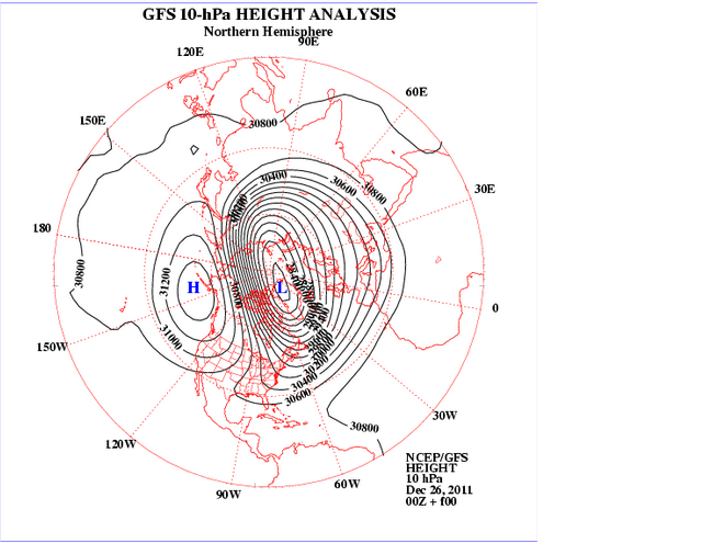
As mentioned repeatedly, the upcoming minor warming (however weak) will have major repercussions in the troposphere. The main effect will be to produce a rotation axis of the polar vortex with major redistribution of vorticity. In particular, the translation of warming from eastern Siberia to Canada will produce a major shift of vorticity of the VP to the Euro-Atlantic sector.
The figure shows the shift of warming on Canada resulting in migration of the centers of vorticity towards the European sector.
In this phase of migration of arctic masses there will be a weak recovery in wave 2 (wave-Atlantic), with the hp of the Azores which will be facilitated to gain ground toward higher latitudes temporarily. This ripple will produce later this year a rapid and very weak foray into the Arctic Mediterranean, whose implications do not seem yet to be fully framed by the models.
In the next phase (beginning of new year), the successful transition of the masses on the Arctic sector Euro Russian by the desplacement layer, an inevitable result of the strengthening of the polar jet over Europe, with a consequent increase in the zonal velocity. This phase will therefore very likely that your hp interference ocean on our country will therefore be affected by weather and mild temperatures for the period, especially during the day (in fact the strong temperature inversion, however, guarantee low temperatures at night, especially in areas internal and in the Po Valley). The persistence dell'anticiclone on Italy, however, should not be very durable. In fact, the propagation of the warming even at lower altitudes would produce a further lowering of the polar jet over western right, favoring the entry of our country short fronts the Atlantic / North Atlantic. It should still be a minor ripple, not able to make big jerks.
Meanwhile, because of the changed position of the VPS is expected to witness the interruption of the inflow of heat from the wave 1 and the upper stratospheric warming quotas should be gradually reabsorbed. Therefore, it should embody a kind of zero at the end of baric disturbances introduced by the previous situation of forcing.
So far the forecast should have a good chance of success. For the later can only make assumptions without much qualitative feedback especially temporally. However I will try to draw a trend line based on some considerations.
First of all is to include the imminent passage of the QBO at 50 hPa in negative territory, proven step by ECMWF forecasts on the trend of zonal wind:
From this paper shows clearly how in 10 days, the share of the equator and 50 hpa (red circle) is already on the QBO value neutral.
The passage of the QBO in the negative at this stage may not have large seasonal shocks as the consequent strengthening of the BDC will have no effects in the polar stratosphere immediately. In fact, the air particles that move from the equator to the poles through the BDC take between 3 to 4 months to get the pole. Therefore, the stratosphere will continue to be locked down. However there are other effects induced by the passage of the QBO negative, in this context, may still be interesting.
First, when the eastern tropical wind regime (QBO-), the tropical easterlies tend to restrict the width of the planetary wave -guides in the extratropical lower stratosphere, favoring a larger amplitude wave and a slower phase. Secondly, the QBO-is able to make an increase in convective activity in the Pacific, especially in areas already covered by the Convention Deep (western Pacific under Nina like). This phenomenon is more exasperated by the low solar activity.
For these reasons I expect that the next tropospheric forcing of the stratospheric polar damage can be more effective than the previous one and therefore is a good time that we are waiting for a long.
The dynamics of the disorder among other things could be quite similar to that which produced the first warming of the season, due to the reactivation of the Wave 3 (Wave Asian). In fact, the wave 3 receives heat (energy) from the Atlantic jet, which, as mentioned above, is expected to sharp increase from next week. Specifically, the intense Atlantic jet, not just cross the continent of Europe, tends to slow for thermodynamic reasons, accumulating a lot of heat in this area (Eurasia).
The pressure-induced reactivation of tropowave 3 ellitticcizzazione induce a new VP, resulting in recovery of heat flow by the wave 1 (EP-FLUX new convergent). At this stage, as indeed said, the amount of energy and heat may be much larger. The heat developed by the new layer for propagation may be more enhanced by the strong interest that the average zonal speed the lower stratosphere for a long time. In short I think there's a good chance of being able to attend a stratwarming respectable, which could have implications in the troposphere also remarkable.
With regard to the timing, you should go for long enough. Let's say that straddles the end of the beginning of January you could have the first three waves of reactivation. This activation may favor, together with the location of the VP ellitticcizata, the slowing of the jet over Europe, with resumption of the Atlantic wave 2 (omega shape of the VP). This could cause a first down on its own arctic continent of Europe. From this point on, would share the flow converged layer with stratospheric beginning of the new disorder, which could last several days. In the third week of the month it reached maturity stratwarming, with implications in the troposphere, which began to take place in late January / early February.
I repeat once again that this is a trend, especially as regards the timing. Therefore, the changes may be considerable. Moreover, the stratospheric forecasts still do not begin to frame any favorable situation. The season is not as we know the good ones and there are these "attacks" even the smallest clues favorable. And then as they say, hope is always the last to die.
INTEGRATION: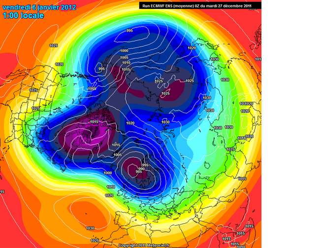
From this image taken from ECMWF ENSEMBLE this morning we see that the models begin to frame the dynamics described at the end of the article. In particular, it is clear the pressure wave induced by the trope of omega-3 resulting in the disposal of the VP. This particular configuration could lead to the end of the first decade of January (maybe later), a first foray into the Arctic on our country, whose trajectory and the consequent implications would obviously all be evaluated. The important thing, which seems to be reflected among others in different emissions modeling today, is that the VP seems to be brought back to ellitticcizzarsi, resulting in recovery of heat flows converging in the stratosphere by the peaceful wave 1. This is a prerequisite in view of the end of the month stratwarming suggested to me.0 -
I came across this from an Italian website so here it is translated,gives some good info in helping to understand. Excuse some sentences that are difficult to understand because of dodgy translation.
The QBO positive in conjunction with the low solar activity leads to a Stratospheric Polar Vortex ( VPS) is completely blocked, due to the semi-block full of "Brewer Dobson Circulation" that stratospheric level, is a real current hemispherical sundial can connect with the polar equatorial regions. In short, when the BDC is very weak, the VPS is very strong and cold as well as affected by stratospheric zonal wind very intense. Thus the entire structure of the polar vortex (VP) is very compact, with very few opportunities to exchange major meridians (Europe swept by the flow of warm ocean zonal matrix). In such a context, in fact, the large planetary waves, whose propagation is prerequisite for the cold air down from high to medium-low latitudes, enter into serious crisis. In other words, because of the high-speed stratospheric zonal, the heat flows from the array of tropical troposphere to the stratosphere polar penetrate up through the propagation of Rossby waves, are strongly divergent.
A similar situation is greatly aggravated by Nina moderate / strong central in nature. The strong trade winds, related to the Walker circulation that blow constantly on the ground over the years affected by the phenomenon of the Nina, potently inhibit the development of the Convention on much of the deep Pacific, being the largest ocean on the planet, turns out to be crucial for As regards the complaints against the VP. The reduction of air deep concern to the Convention has 2 effects:
1) further reduction of the strength of the BDC that much depends on the convective Pacific and in particular the amount of water vapor which, through the tropopause, the stratosphere Equatorial penetrate;
2) reduction of heat that flows from the troposphere into the stratosphere polar penetrate through the "breakthrough" in the layer of Rossby waves. Said terms "playful", the tropical heat of the Convention is a fuel for the formation of large, long waves can break into the stratosphere.
The situation described so far is "photographed" by some key images. First of all I report an image, captured by the satellite OMI-AURA, representing the amount of ozone in the polar stratosphere in early December. In this regard, remember that ozone transport from equatorial latitudes (where it originates) to the polar is related to the intensity of the BDC. Therefore the amount of ozone in the VPS is a good index to measure the strength of the BDC.
You can easily see the ozone hole just above the North Pole.
Secondly carry the image from ECMWF carriers on the EP-FLUX. In two words, remember that these vectors represent the amount of heat fluxes and momentum from the troposphere to penetrate the polar stratosphere. Therefore, the longer vectors indicate a good propagation and vertical flow of heat from the trope of the layer (good wave propagation).
You will notice that until mid-December (red circle) patterns were completely different, a symptom of a VPS in great shape. Precisely in this period were reached in the polar stratosphere temperatures very low, near-record. In the second half of the month but something has changed since the first heat fluxes have been able to penetrate in part into the stratosphere (green circle). This forcing, started as told in the middle of the month and due in large part to the action of the continuous wave 1 (wave-Pacific), will in the coming days to less warming of the first season.
As I have repeatedly pointed out in comments made in the weather , the disorder is not at all associated with a dynamic thrust of the wave 1 (elevation of the Aleutian hp), but to a particular location of the lower middle VPS that has allowed the vortex semi-permanent Aleutian taking a particularly favorable position. Specifically, the continuing dynamic action induced by the tropo-wave 3 (Asian wave) led the Polar Vortex in the lower stratosphere, to assume a configuration with a major axis ellitticizzata highly favorable (Canada-Eastern Siberia). This location has enabled VPS elliptical same "catch air" right where you are in fact the only obvious sources of heat in the Pacific under the like Nina (+ SSTA in the western Pacific).
This trend is clearly perceptible even from paper to 500hPa (with which you certainly more familiar). In this regard, the red arrow represents the pressure exerted by the wave 3 resulting ellitticizzazione the VP (the axis of the ellipse is highlighted by orange arrow).
That dynamic has allowed, as mentioned, discrete inflow of heat by the wava 1 and the resulting first discrete stratospheric warming of the season, as well detectable by the following paper 10 hpa:
As mentioned repeatedly, the upcoming minor warming (however weak) will have major repercussions in the troposphere. The main effect will be to produce a rotation axis of the polar vortex with major redistribution of vorticity. In particular, the translation of warming from eastern Siberia to Canada will produce a major shift of vorticity of the VP to the Euro-Atlantic sector.
The figure shows the shift of warming on Canada resulting in migration of the centers of vorticity towards the European sector.
In this phase of migration of arctic masses there will be a weak recovery in wave 2 (wave-Atlantic), with the hp of the Azores which will be facilitated to gain ground toward higher latitudes temporarily. This ripple will produce later this year a rapid and very weak foray into the Arctic Mediterranean, whose implications do not seem yet to be fully framed by the models.
In the next phase (beginning of new year), the successful transition of the masses on the Arctic sector Euro Russian by the desplacement layer, an inevitable result of the strengthening of the polar jet over Europe, with a consequent increase in the zonal velocity. This phase will therefore very likely that your hp interference ocean on our country will therefore be affected by weather and mild temperatures for the period, especially during the day (in fact the strong temperature inversion, however, guarantee low temperatures at night, especially in areas internal and in the Po Valley). The persistence dell'anticiclone on Italy, however, should not be very durable. In fact, the propagation of the warming even at lower altitudes would produce a further lowering of the polar jet over western right, favoring the entry of our country short fronts the Atlantic / North Atlantic. It should still be a minor ripple, not able to make big jerks.
Meanwhile, because of the changed position of the VPS is expected to witness the interruption of the inflow of heat from the wave 1 and the upper stratospheric warming quotas should be gradually reabsorbed. Therefore, it should embody a kind of zero at the end of baric disturbances introduced by the previous situation of forcing.
So far the forecast should have a good chance of success. For the later can only make assumptions without much qualitative feedback especially temporally. However I will try to draw a trend line based on some considerations.
First of all is to include the imminent passage of the QBO at 50 hPa in negative territory, proven step by ECMWF forecasts on the trend of zonal wind:
From this paper shows clearly how in 10 days, the share of the equator and 50 hpa (red circle) is already on the QBO value neutral.
The passage of the QBO in the negative at this stage may not have large seasonal shocks as the consequent strengthening of the BDC will have no effects in the polar stratosphere immediately. In fact, the air particles that move from the equator to the poles through the BDC take between 3 to 4 months to get the pole. Therefore, the stratosphere will continue to be locked down. However there are other effects induced by the passage of the QBO negative, in this context, may still be interesting.
First, when the eastern tropical wind regime (QBO-), the tropical easterlies tend to restrict the width of the planetary wave -guides in the extratropical lower stratosphere, favoring a larger amplitude wave and a slower phase. Secondly, the QBO-is able to make an increase in convective activity in the Pacific, especially in areas already covered by the Convention Deep (western Pacific under Nina like). This phenomenon is more exasperated by the low solar activity.
For these reasons I expect that the next tropospheric forcing of the stratospheric polar damage can be more effective than the previous one and therefore is a good time that we are waiting for a long.
The dynamics of the disorder among other things could be quite similar to that which produced the first warming of the season, due to the reactivation of the Wave 3 (Wave Asian). In fact, the wave 3 receives heat (energy) from the Atlantic jet, which, as mentioned above, is expected to sharp increase from next week. Specifically, the intense Atlantic jet, not just cross the continent of Europe, tends to slow for thermodynamic reasons, accumulating a lot of heat in this area (Eurasia).
The pressure-induced reactivation of tropowave 3 ellitticcizzazione induce a new VP, resulting in recovery of heat flow by the wave 1 (EP-FLUX new convergent). At this stage, as indeed said, the amount of energy and heat may be much larger. The heat developed by the new layer for propagation may be more enhanced by the strong interest that the average zonal speed the lower stratosphere for a long time. In short I think there's a good chance of being able to attend a stratwarming respectable, which could have implications in the troposphere also remarkable.
With regard to the timing, you should go for long enough. Let's say that straddles the end of the beginning of January you could have the first three waves of reactivation. This activation may favor, together with the location of the VP ellitticcizata, the slowing of the jet over Europe, with resumption of the Atlantic wave 2 (omega shape of the VP). This could cause a first down on its own arctic continent of Europe. From this point on, would share the flow converged layer with stratospheric beginning of the new disorder, which could last several days. In the third week of the month it reached maturity stratwarming, with implications in the troposphere, which began to take place in late January / early February.
I repeat once again that this is a trend, especially as regards the timing. Therefore, the changes may be considerable. Moreover, the stratospheric forecasts still do not begin to frame any favorable situation. The season is not as we know the good ones and there are these "attacks" even the smallest clues favorable. And then as they say, hope is always the last to die.
INTEGRATION:
From this image taken from ECMWF ENSEMBLE this morning we see that the models begin to frame the dynamics described at the end of the article. In particular, it is clear the pressure wave induced by the trope of omega-3 resulting in the disposal of the VP. This particular configuration could lead to the end of the first decade of January (maybe later), a first foray into the Arctic on our country, whose trajectory and the consequent implications would obviously all be evaluated. The important thing, which seems to be reflected among others in different emissions modeling today, is that the VP seems to be brought back to ellitticcizzarsi, resulting in recovery of heat flows converging in the stratosphere by the peaceful wave 1. This is a prerequisite in view of the end of the month stratwarming suggested to me.
For those who do not have a Doctorate in Meteorology, what is this post saying?
Is the stratosphere actually warming up with potential for a cold out break further south in mid to late January?
D0 -
Advertisement
-
Join Date:Posts: 6780
I came across this from an Italian website so here it is translated,gives some good info in helping to understand. Excuse some sentences that are difficult to understand because of dodgy translation.
The QBO positive in conjunction with the low solar activity leads to a Stratospheric Polar Vortex ( VPS) is completely blocked, due to the semi-block full of "Brewer Dobson Circulation" that stratospheric level, is a real current hemispherical sundial can connect with the polar equatorial regions. In short, when the BDC is very weak, the VPS is very strong and cold as well as affected by stratospheric zonal wind very intense. Thus the entire structure of the polar vortex (VP) is very compact, with very few opportunities to exchange major meridians (Europe swept by the flow of warm ocean zonal matrix). In such a context, in fact, the large planetary waves, whose propagation is prerequisite for the cold air down from high to medium-low latitudes, enter into serious crisis. In other words, because of the high-speed stratospheric zonal, the heat flows from the array of tropical troposphere to the stratosphere polar penetrate up through the propagation of Rossby waves, are strongly divergent.
A similar situation is greatly aggravated by Nina moderate / strong central in nature. The strong trade winds, related to the Walker circulation that blow constantly on the ground over the years affected by the phenomenon of the Nina, potently inhibit the development of the Convention on much of the deep Pacific, being the largest ocean on the planet, turns out to be crucial for As regards the complaints against the VP. The reduction of air deep concern to the Convention has 2 effects:
1) further reduction of the strength of the BDC that much depends on the convective Pacific and in particular the amount of water vapor which, through the tropopause, the stratosphere Equatorial penetrate;
2) reduction of heat that flows from the troposphere into the stratosphere polar penetrate through the "breakthrough" in the layer of Rossby waves. Said terms "playful", the tropical heat of the Convention is a fuel for the formation of large, long waves can break into the stratosphere.
The situation described so far is "photographed" by some key images. First of all I report an image, captured by the satellite OMI-AURA, representing the amount of ozone in the polar stratosphere in early December. In this regard, remember that ozone transport from equatorial latitudes (where it originates) to the polar is related to the intensity of the BDC. Therefore the amount of ozone in the VPS is a good index to measure the strength of the BDC.
You can easily see the ozone hole just above the North Pole.
Secondly carry the image from ECMWF carriers on the EP-FLUX. In two words, remember that these vectors represent the amount of heat fluxes and momentum from the troposphere to penetrate the polar stratosphere. Therefore, the longer vectors indicate a good propagation and vertical flow of heat from the trope of the layer (good wave propagation).
You will notice that until mid-December (red circle) patterns were completely different, a symptom of a VPS in great shape. Precisely in this period were reached in the polar stratosphere temperatures very low, near-record. In the second half of the month but something has changed since the first heat fluxes have been able to penetrate in part into the stratosphere (green circle). This forcing, started as told in the middle of the month and due in large part to the action of the continuous wave 1 (wave-Pacific), will in the coming days to less warming of the first season.
As I have repeatedly pointed out in comments made in the weather , the disorder is not at all associated with a dynamic thrust of the wave 1 (elevation of the Aleutian hp), but to a particular location of the lower middle VPS that has allowed the vortex semi-permanent Aleutian taking a particularly favorable position. Specifically, the continuing dynamic action induced by the tropo-wave 3 (Asian wave) led the Polar Vortex in the lower stratosphere, to assume a configuration with a major axis ellitticizzata highly favorable (Canada-Eastern Siberia). This location has enabled VPS elliptical same "catch air" right where you are in fact the only obvious sources of heat in the Pacific under the like Nina (+ SSTA in the western Pacific).
This trend is clearly perceptible even from paper to 500hPa (with which you certainly more familiar). In this regard, the red arrow represents the pressure exerted by the wave 3 resulting ellitticizzazione the VP (the axis of the ellipse is highlighted by orange arrow).
That dynamic has allowed, as mentioned, discrete inflow of heat by the wava 1 and the resulting first discrete stratospheric warming of the season, as well detectable by the following paper 10 hpa:
As mentioned repeatedly, the upcoming minor warming (however weak) will have major repercussions in the troposphere. The main effect will be to produce a rotation axis of the polar vortex with major redistribution of vorticity. In particular, the translation of warming from eastern Siberia to Canada will produce a major shift of vorticity of the VP to the Euro-Atlantic sector.
The figure shows the shift of warming on Canada resulting in migration of the centers of vorticity towards the European sector.
In this phase of migration of arctic masses there will be a weak recovery in wave 2 (wave-Atlantic), with the hp of the Azores which will be facilitated to gain ground toward higher latitudes temporarily. This ripple will produce later this year a rapid and very weak foray into the Arctic Mediterranean, whose implications do not seem yet to be fully framed by the models.
In the next phase (beginning of new year), the successful transition of the masses on the Arctic sector Euro Russian by the desplacement layer, an inevitable result of the strengthening of the polar jet over Europe, with a consequent increase in the zonal velocity. This phase will therefore very likely that your hp interference ocean on our country will therefore be affected by weather and mild temperatures for the period, especially during the day (in fact the strong temperature inversion, however, guarantee low temperatures at night, especially in areas internal and in the Po Valley). The persistence dell'anticiclone on Italy, however, should not be very durable. In fact, the propagation of the warming even at lower altitudes would produce a further lowering of the polar jet over western right, favoring the entry of our country short fronts the Atlantic / North Atlantic. It should still be a minor ripple, not able to make big jerks.
Meanwhile, because of the changed position of the VPS is expected to witness the interruption of the inflow of heat from the wave 1 and the upper stratospheric warming quotas should be gradually reabsorbed. Therefore, it should embody a kind of zero at the end of baric disturbances introduced by the previous situation of forcing.
So far the forecast should have a good chance of success. For the later can only make assumptions without much qualitative feedback especially temporally. However I will try to draw a trend line based on some considerations.
First of all is to include the imminent passage of the QBO at 50 hPa in negative territory, proven step by ECMWF forecasts on the trend of zonal wind:
From this paper shows clearly how in 10 days, the share of the equator and 50 hpa (red circle) is already on the QBO value neutral.
The passage of the QBO in the negative at this stage may not have large seasonal shocks as the consequent strengthening of the BDC will have no effects in the polar stratosphere immediately. In fact, the air particles that move from the equator to the poles through the BDC take between 3 to 4 months to get the pole. Therefore, the stratosphere will continue to be locked down. However there are other effects induced by the passage of the QBO negative, in this context, may still be interesting.
First, when the eastern tropical wind regime (QBO-), the tropical easterlies tend to restrict the width of the planetary wave -guides in the extratropical lower stratosphere, favoring a larger amplitude wave and a slower phase. Secondly, the QBO-is able to make an increase in convective activity in the Pacific, especially in areas already covered by the Convention Deep (western Pacific under Nina like). This phenomenon is more exasperated by the low solar activity.
For these reasons I expect that the next tropospheric forcing of the stratospheric polar damage can be more effective than the previous one and therefore is a good time that we are waiting for a long.
The dynamics of the disorder among other things could be quite similar to that which produced the first warming of the season, due to the reactivation of the Wave 3 (Wave Asian). In fact, the wave 3 receives heat (energy) from the Atlantic jet, which, as mentioned above, is expected to sharp increase from next week. Specifically, the intense Atlantic jet, not just cross the continent of Europe, tends to slow for thermodynamic reasons, accumulating a lot of heat in this area (Eurasia).
The pressure-induced reactivation of tropowave 3 ellitticcizzazione induce a new VP, resulting in recovery of heat flow by the wave 1 (EP-FLUX new convergent). At this stage, as indeed said, the amount of energy and heat may be much larger. The heat developed by the new layer for propagation may be more enhanced by the strong interest that the average zonal speed the lower stratosphere for a long time. In short I think there's a good chance of being able to attend a stratwarming respectable, which could have implications in the troposphere also remarkable.
With regard to the timing, you should go for long enough. Let's say that straddles the end of the beginning of January you could have the first three waves of reactivation. This activation may favor, together with the location of the VP ellitticcizata, the slowing of the jet over Europe, with resumption of the Atlantic wave 2 (omega shape of the VP). This could cause a first down on its own arctic continent of Europe. From this point on, would share the flow converged layer with stratospheric beginning of the new disorder, which could last several days. In the third week of the month it reached maturity stratwarming, with implications in the troposphere, which began to take place in late January / early February.
I repeat once again that this is a trend, especially as regards the timing. Therefore, the changes may be considerable. Moreover, the stratospheric forecasts still do not begin to frame any favorable situation. The season is not as we know the good ones and there are these "attacks" even the smallest clues favorable. And then as they say, hope is always the last to die.
INTEGRATION:
From this image taken from ECMWF ENSEMBLE this morning we see that the models begin to frame the dynamics described at the end of the article. In particular, it is clear the pressure wave induced by the trope of omega-3 resulting in the disposal of the VP. This particular configuration could lead to the end of the first decade of January (maybe later), a first foray into the Arctic on our country, whose trajectory and the consequent implications would obviously all be evaluated. The important thing, which seems to be reflected among others in different emissions modeling today, is that the VP seems to be brought back to ellitticcizzarsi, resulting in recovery of heat flows converging in the stratosphere by the peaceful wave 1. This is a prerequisite in view of the end of the month stratwarming suggested to me.
Im going to wait till i have a few on board later on to have a read of this ! its will be great crack !0 -
Did ya's really have to quote the whole post twice :pac:0
-
-
-
Join Date:Posts: 6780
Well with the ECM back on again so time for another update.
Firstly, we see some agreement between the ECM and GFS with regards to another warming at the 10 hPa level.
In fact we are seeing varying degrees of warmings continually bouncing off the surf zone, weakening the vortex as they do so. Here is the latest at T+ 240. Note shuggee that this is just another peak during the continual surf zone attack.
The vortex displacement and elongation is carried right down to the 100hPa level though the vortex is still forecast to be more centrally placed here - that is why any amplification in the tropospheric flow is still struggling to break through the Greenland area - so far.
However it should be noted that the 100 hPa mean zonal 60ºN winds are forecast to reduce slowly over the next ten days. This is crucial as the tropospheric vortex strength will reduce in line with this and it won't be long after that we see further blocking solutions offered.
More importantly, with there being no sign of let up in the warming of the middle stratosphere we are likely to see tropospheric high latitude blocking chances increase as time progresses - even without a SSW.
So all in all the promise for the second half of January is very much welcome. Lets hope that we are on the receiving end of any cold that heads south!0 -
WOW this from Glacier Point Chief Forecaster on NW
EDIT Links now work
Big, big spike in tendency of relative angular momentum showing up...
http://www.esrl.noaa.gov/psd/map/images/reanalysis/aam_total/gltend.sig.90day.gif
and there's a big + Asian Mountain Torque in there which will: extend the Asian Jet into the Pacific setting up the conditions for the Aleutian ridge; and, bring about further wave breaking into the polar stratosphere for the next 10-15 days. It was a similar spike in angular momentum which preceded our cold outbreaks of the last two winters.
The ensemble means have, if anything, begun to lock onto a negative Arctic Oscillation with the 'switch over' centred around 11th January. GEFS control going through the floor. Most of the +ve anomalies centred on the Pacific and Siberian sectors.
http://policlimate.com/weather/oscillation.html
Long range tools indicate temperatures for our neck of the woods trending average or slightly below given night time frosts although there is something of a change in the pace of change during mid month as the possible double whammy of tropospheric changes and stratospheric warming (this one a plausible major mid winter warming) coincide around this time.
Northerly attacks along a trough dropping into Europe look the most likely pattern from mid month, potentially going more unsettled as the trough expands into the Atlantic - cold zonality anyone, followed by a genuine cold source Scandinavian ridge ?0 -
My Temp Anomaly graph from page 1 is now complete and the minor Strat warming can be clearly seen in the upper levels.
Remember these warmings are helping to weaken the Polar Vortex but i'd like to see more.
Now carrying on from that graph,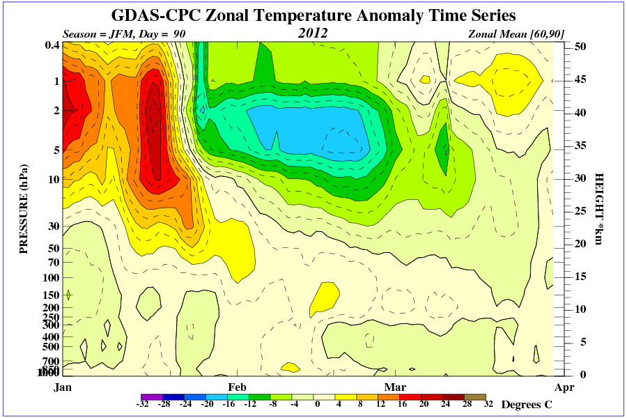
Good healthy climb from the 30hpa graph between 90n - 65n 0
0 -
Join Date:Posts: 6780
Today we see the best stratospheric ECM forecast of the season so far. This is probably in response to the latest strong Asian MT event that has caused wave breaking up into the stratosphere. With the stratospheric vortex already slightly weakened by the previous warming events wil this latest warming be enough for a knockout blow?
Well we can't tell yet but signs are encouraging.
Firstly we have another negative zonal mean wing forecast right at the top of the stratosphere (1hPa) at T+240.
This is strong enough to displace the vortex off the pole at this level .... but we need to see propagation down to lower levels for this to have any effect on the troposphere.
Signs are good, firstly we have a reduced mean zonal wind, due to the displacement, throughout the stratosphere. At the 10 hPa level both the warming and displacement is evident.
This is the crucial level that mean zonal mean winds would have to reverse at 60N to achieve a SSW.
However, I am more interested at this stage in how any stratospheric disturbances are played out tropospherically rather than achieving a technical SSW.
To look at this we need to look even lower down the stratosphere and for the first time the displacement of the vortex is forecast to have strong effect at the 100 hPa level.
Here we see both a displacement and split of the vortex. This is so positioned that initailly we would a receive a northerly flow - no toppler here due to the lack of strong vorticity on the western Atlantic side.
How things develop from here hold a lot of interest - where will the vortex go next?
I am unable to say so far but hopefully the GFS will give us a clue later.
For those who have been following the stratosphere this winter we could be seeing a winter that demonstrates very well why a favourable or unfavourable stratosphere is so important on tropospheric weather patterns.0 -
Interesting read here from the USA in '85 when the Polar Vortex shifted.
Excuse if it has already been posted.
http://www.answers.com/topic/january-1985-arctic-outbreak0 -
Advertisement
-
Thanks Pete, following with great interest and trying to piece together the important parameters to understand the sequence.
Stephane0


Advertisement