Chris_5339762 wrote: » M7 I guess, only because it effectively services Limerick, Cork and Waterford in places
Furet wrote: » I'm not talking about towns directly served by junctions; rather areas the would use the motorway by going through other places first: e.g.: West Cork (Skibb, Clonakilty, Bandon, etc.) uses the M8 to access Dublin.
Hogzy wrote: » I dont really get what your saying, been studying all day and the brain is fried Can you word it a bit different?
Furet wrote: » Ok: the M8 is Dublin to Cork City, and it obviously serves all towns located in the immediate vicinity of the route. My question relates to towns and areas NOT immediately next to the route that are nonetheless served by the M8, such as towns like Skibbereen, because anyone in or near Skibb that wants to drive to Dublin will be taking the M8 once they reach Cork. Now, taking all these far-flung towns and hinterlands into account, which of the new interurbans serve the greatest number of 'far-flung' towns? My brain is fried too, and that's the best I can manage right now...:o
tech2 wrote: » M7 will be serving a large area. South Clare, County Limerick, some of county tipp, offaly and Kerry will use the M7.
Furet wrote: » I was thinking it'd be the M7 as well. Yet it's traffic counts aren't exorbitantly high when compared to the M8 or M6. I'm expecting a substantial growth in AADT in the next decade or so as people make the journey to Dublin more often, owing to better roads and reduced journey times.
Hogzy wrote: » How long do you think it will be before the M7 (from M8 turnoff to Naas) will be upgraded to three lanes? Would you see it happening in the next 10yrs?
Furet wrote: » Certainly not within the next 20 or 30 years or more. I just can't see it being necessary before then and even if it was, the response would be slow.
Hogzy wrote: » Inevitably our motorways will have to be upgraded to 3 lanes...in the distant future. Will it be tough to do? Would all the bridges have to be rebuilt?
Carawaystick wrote: » The A4 west of Reims is only D2M and that's one of the main routes from Paris to Germany
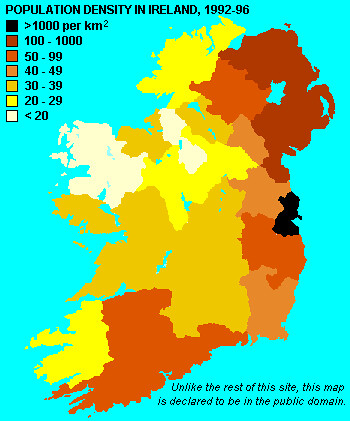
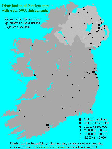
johnbk wrote: » If you looked at the second of these two maps (and know nothing else about Ireland) annd were asked to draw a suitable motorway network, I dont think you could come up with anything that looks like what we have now.
Furet wrote: » Ok: the M8 is Dublin to Cork City, and it obviously serves all towns located in the immediate vicinity of the route. My question relates to towns and areas NOT immediately next to the route that are nonetheless served by the M8, such as towns like Skibbereen, because anyone in or near Skibb that wants to drive to Dublin will be taking the M8 once they reach Cork. Now, taking all these 'far-flung' towns and hinterlands into account, which of the new interurbans serves the greatest number of far-flung towns? My brain is fried too, and that's the best I can manage right now...:o
Stark wrote: » I know I for one use the M8 a lot when heading to Kerry (especially if it's South Kerry) but once the M7 is finished, I'll be switching over to using the M7 route as the N21 is much better road than the N73/N72. It's just at the moment, the single carriageway sections on the N7 are headwreckers.
Carawaystick wrote: » I don't think it's inevitable that the roads will ever need widening. Looking at the network in France, the A10 is D2M most of the way between Paris and Bordeaux and onto the Basque side of Spain as the E05 (N10/A63) On the other side of France, the A9 is D2M from Perpignan south to the Border. This route is planned to be upgraded at some stage, but considering the sheer amount of trade these two routes carry ad they function fairly well as D2M as it is. Elsewhere the Autoroute des deux Mers from Bordeaux to Narbonne is D2M, bar climbing lanes on the hilly bits, something we don't really have bar a bit of the N8 (hilly bits, not climbing lanes) The A4 west of Reims is only D2M and that's one of the main routes from Paris to Germany
Hogzy wrote: » Its data is nearly 20 years old. Ireland has grown substantially since then. If you did a 2010 version you would see a hell of a lot of towns get larger icons and towns that are not represented on the map have become much larger so would be represented by an icon. Eg. in 2006 Ennis had 25k people and Bandon had 5k+ people.
Furet wrote: » I don't think it's inevitable at all.... just the sections where interurban routes converge. For the most part it wouldn't be too hard (the M7 and M1 have broad central divides that could be used for additional lane space). Certainly I can't ever see the M6, M8 and M9 (and the M7 west of the motorway-motorway interchanges) ever at capacity. Most bridges would present no problems, bar the M7/M8 bridges, and any others which have supports at the sides of the carriageway rather than in the centre.