It looks like we're in for a very large, if not the largest El Niño ever…
https://www.bbc.com/weather/articles/cvgzn11v421o
https://edition.cnn.com/2026/05/14/weather/super-el-nino-climate
We could be looking at the last 10 years or so of catastrophic weather events being considered minor events compared to what could come…
https://www.euronews.com/2026/05/12/from-record-heat-to-floods-and-drought-whats-in-store-if-a-super-el-nino-hits-this-year
Very interesting, and climate change will make these events worse again.
https://www.wunderground.com/article/news/climate/news/2026-05-07-super-el-nino-forecast-may2026
"For example, parts of Africa, India, Australia, the Philippines, Indonesia, the Caribbean and northern South America trend markedly drier during El Niño.
On the other hand, warm water and lighter trade winds typically sets the table for heavier rain in parts of Ecuador and Peru. Parts of eastern Africa, central Asia, Chile, Uruguay and Paraguay are also usually wetter than average during El Niño."
It will also be wetter for much of the Southern US while it also dampens down Atlantic hurricanes.
How does Ireland generally fare during super El ninos?
Varies. Warmer and wetter but sometimes very warm Summers too. This Summer has been forecast warm on a lot of platforms more so in the South and East.
I'd be surprised if this Nov and dec are not dull and very mild washouts. I'd therefore be surprised if there are not flooding issues in parts of the country by the end of the year.
Is in not the summer following the El Niño that we feel it's effects? as in it'll be summer 2027 before we see anything?
Yes — this is my understanding. The El Nino hasn't even occurred yet so it won't have any impact on our weather this summer. Or maybe even this winter. It's 2027 when most of the effects will occur. Although the correlation between El Nino and weather patterns in Europe is much weaker compared to places like Australia, California and parts of Asia.
Dr Friederike Otto, Professor in Climate Science at Imperial College London
"Not the reason to freak out"
while there can be a certain amount of lag regarding next yr we will surely see its effects in some way next winter. For example the El Nino of 2015 I'm sure played a part in giving Ireland its warmest December on record that year.
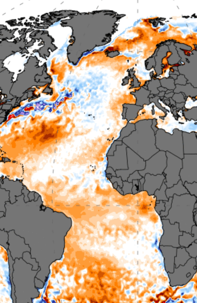
The North Atlantic cold blob was aided by the El Niño event which in turn was a massive player in the monsterous +NAO setup that drove Dec 2015. The North Atlantic is normally a bit cooler during an El Niño (the reverse of the Pacific) compared to a La Niña. 2023 was highly unusual in that regard but it’s been well documented that 2023 warmth was likely influenced by a change in regulations surrounding shipping aerosols or excess water vapour from Hunga Tonga.
The stratospheric polar vortex (as much of a joke this has seemed in recent years) was also exceptionally strong driving home an enhanced Atlantic flow.
That Tonga eruption sent loads of moisture up into the atmosphere that supposedly contribute to our very damp spring in 2023.
wonder will we get a similar December this yr like 2015 with the cold blob + El Nino
current Atlantic ssts
https://www.rte.ie/radio/radio1/clips/22618025/ radio clip
https://www.rte.ie/news/environment/2026/0602/1576289-el-nino-un/ article
An outside possibility is Ireland getting a tropical storm/hurricane spin off from the Atlantic like Ophelia.
There was an 1877 Super El Nino that heavily impacted several regions' food production at the time, causing many deaths from hunger, today we have better food systems but a lot more people and modern agriculture is still very dependent on a reliable climate.
Given the world is heating up, it's also important to see how already elevated global temperatures increase the potential impacts of the extra heat from the expected El Nino in the next twelve months and how much the baseline global temperature is shifted upwards coming out of it.
It could be 2027 when the broader impacts are most felt.
Talking of ocean currents and heat transfers, Ireland has its own concerns scientists are flagging around a weakening of the AMOC which brings the heat that provides us with our milder Winters and helps bring plenty of moisture.
In late 17 we got ophelia and then in early 2018 we the beast from the east and then the summer was crazy warm, I remember we must have had 60 odd days in a row of really hot dry weather, was that an el nino event?
No, it was in fact the opposite. A rather weak La Niña event.
Hi @sryanbruen Has there been any cold/snowy winters in Ireland when there was a super El Niño? I’m guessing no but interested to see if any winter proved to be the exception to the rule.
The problem is there's been very few winters that can constitute as a super El Niño. The only years that apply are 1877-78, 1982-83, 1997-98 and 2015-16.
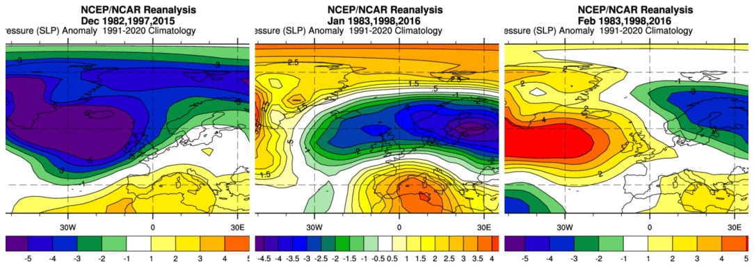
Due to the very small sample size, these won't be of much use but this is how the most recent three years look on a month by month basis. The composite generator does not go back as far as 1877-78.
December shows a rampant +NAO signature with deep Atlantic low pressure bringing very wet and stormy conditions. January shows more blocking in the higher latitudes but plenty of ridging over southern Europe as well meaning it's still a flat unsettled westerly for us. February gives mid-Atlantic ridging with low pressure focused towards Scandinavia. Still a good bit of ridging over southern Europe as well however. These composites lend to the theory that El Niño winters have higher possibility of -NAO later in winter compared to earlier.
Looking at the individual years themselves, 1982-83 was mostly unsettled with a mild stormy January whilst February was colder and more wintry. February 1983 is by far the coldest month out of all of them here.
1997-98 was exceptionally mild. December 1997 had a period of easterly winds but not a lot of cold air to tap into. Both January and February 1998 had record-breaking mild temperatures with 18C in January and 17s in February. January pretty unsettled and stormy until the final week whilst February was mostly dry.
2015-16 had the wettest month recorded in Ireland in December 2015. January and February 2016 were also very wet giving one of the wettest winters on record in the country. There was some wintry weather in the form of flurries around Valentine's 2016.
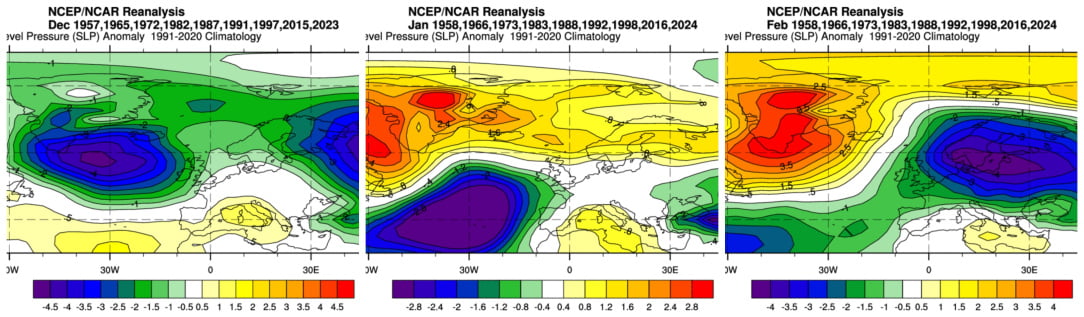
If we include the strong El Niños too rather than just the super ones, this is how the composites look.
Similar theme in December, very unsettled and Atlantic driven. January and February a lot more interesting. January still leaning towards the mild unsettled side due to a west based -NAO signature. February is very blocked over Greenland with deep low pressure to our east. Still a bit of higher pressure in the med so not a clear cut cold chart but a lot better than the previous one. Again though there is a theme for -NAO later in the winter compared to earlier. Bear in mind, 1998 is the warmest February on record and 2024 was up there as well yet both were El Niño.
Thanks so much for the detailed response.
Well based on the above I think it’s safe to say that this December and most of January will probably be blowtorch southwesterly winter months and quite wet with perhaps a colder February 2027.
2017 started with a weak la nina, moved marginally positive (neutral) over the Summer and went back to a weak la nina by the Autumn. My thinking on another tropical storm/hurricane getting closer to Ireland again is that the more heat in the system the more likely these events are going to be. They need warmer water to sustain their cohesion for the journey further north. There's some extra heat in the water along a potential path south south west of Ireland which is worth keeping an eye on for whether it heats up or otherwise relatively speaking. Countering that this year, the el nino does tend to limit tropical storm formation, hence the mostly lower than average hurricane season forecast. There's an argument that this super el nino rather sets the table for a future year of neutral/la nina that produces another such storm using the extra heat in the system and more favourable wind and moisture conditions. There comes a point when the extra heat in the system puts what we value in danger and my fear is that we are not acting commensurate to that danger yet and that this super el nino on top of existing extra heating will begin to expose frailties in global food supplies which in turn negatively impacts the architecture of modern societies.
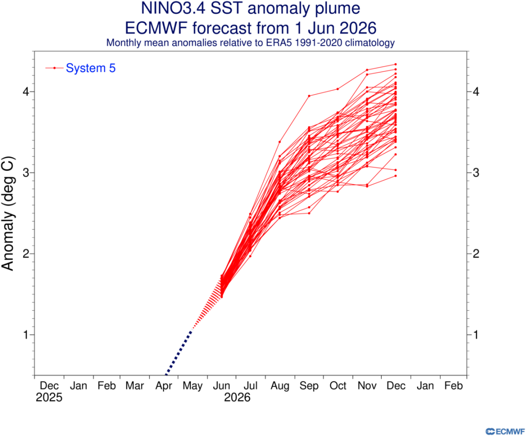
The latest ECMWF Nino3.4 SST anomaly forecast is very strong. Historic for the wrong reasons. While still a forecast it does emphasise the need to raise awareness of the threat and urgency to prepare for potential food production damage in certain regions of the world and food prices globally. All the extra heat in the system goes somewhere.
Ryan Maue
The 2026 El Nino has formed and is expected to gain in strength. NOAA
The probabilities point to a very strong El Nino towards the end of the year, start of next year.
What does this mean for us? Wetter winter?
As sryanbruen has above, the direct impact is potentially to be a warmer wetter winter. The broader global impact of a very strong El Nino should result in some areas getting a lot wetter and others getting a lot less rain and that could severely impact food production in several nations. Add that food production reduction to the problems currently impacting fertiliser supplies and the cumulative increase in global heat already impacting on global food systems and it could be a major impact on the supply of food. In Ireland that would be more price increases rather than significant shortages but in some parts of the world it could put severe pressure on a basic level of food for populations. Food price hikes, food shortages make people angry and desperate and that is destabilising for nations states which turns a weather crisis into a societal crisis and the heating humanity is putting into the system keeps making that more likely. The truth is because this El Nino could be unprecedented and indications are pointing in that direction, so the impacts could be unprecedented in directions/intensities that haven't been felt before. With the extra heat in the system, there's more energy for tropical storms but the nature of heat in the Nino area of the Pacific means the main development area of the Atlantic Hurricanes is suppressed, but it's still expected that there'll be 8-14 named storms. How the Atlantic Ocean sea surface temperatures manifest over the season will contribute to where and how intensely they will develop.
An interview with Ben Noll on the David McCullagh show on the developing Super El Nino.
https://www.rte.ie/radio/radio1/clips/22622711/
We need to consider if some of the extra heat coming into Europe this month is related to the developing El Nino and whether the amount of heat that will get into Western Europe is going to increase as it develops further. What the extra global heat of this expected super el nino means in terms of heat-related problems on European agriculture and societies; the heat itself, the drought potential and the greater concentration of rainfall. All this on top of pre-existing global heating and not just this year but into 2027 and the aftermath. There are several other parts of the world that will likely be significantly more impacted by the el nino than Europe, but this is shaping up to be truly global in its impacts because the heat is likely to be unprecedented in scale.
One of the hypothesis around why Western Europe is getting consecutive heat anomalies is the cold Atlantic "blob" in the mid North Atlantic where at times it steers winds around it. Given the already significant El Nino temperature anomaly this early in the Summer, it will add heat to the peak Summer temperatures in the northern hemisphere which is not good. Expectations of a historic Super El Nino peak into the Autumn and Winter continue.
"Essentially, an El Niño serves as a way for the ocean to release heat that has been accumulating in its waters, and as Tom Harris notes, there is a lot of that heat.
Global ocean heat uptake jumped by a staggering 23 zettajoules (ZJ) in 2025 alone. For context, 23 ZJ is roughly 200 times the total annual electricity generation of the entire human race. The 2025 ocean heat uptake represents an eight-fold increase over the 1958–1985 annual mean baseline
The degree to which we’ve been storing global warming in the oceans can’t be overstated, and now the door to that sauna is being flung open. You may recall the shock a few years ago when global temperatures started occasionally breaching the 1.5 Celsius mark; Harris cites predictions that we could see months in 2027 when we go past the two-degree mark. Jim Hansen and his team just published a new paper predicting that the El Niño is coming fast enough that 2026 will likely set a new record for global temperature"
Now where? - by Bill McKibben - The Crucial Years
The degree to which we’ve been storing global warming in the oceans can’t be overstated, and now the door to that sauna is being flung open.
This is the bit that has really jarred me..
So essentially: "We ain't seen nothin' yet"?
Key words "on record". In the hundreds of millions of years Earth has been around we have only been measuring for 150 years. For the planet will be fine, just humanity and some other inhabitants will be screwed. Other species will evolve and maybe even new "intelligent" life. We are only short term renters.
We're starting to see the heat causing extremes but this El Nino is likely a step-change where the global temperature goes up temporarily but the baseline temperature doesn't come down this far again. The expectation that this El Nino will be historic means we don't have a full handle on how bad the impacts will be, for how long they'll last and just how much a hotter planet forces us to adapt. The heat that threatens life, the drought that threatens food and the floods that could threaten both. Wildfires and melting ice caps/glaciers as a result of the extra heat could compound the heating by trapping even more heat while also threatening key water supplies for rivers, food production and human consumption.
There are tipping points in the Earth's climate systems/biosphere that this El Nino will put pressure on but there'll also be a tipping point in our general understanding of the danger we are in, the hope is that we reach that tipping point quicker than some of the other ones and kick-start the process whereby humanity takes ownership of our place in the world, our impacts on the world and anticipate and avoid the worst of it rather than react and adapt to the bad things we are beginning to see. It's a race to see which one wins, if you can do something to help the better outcomes, do it, while there is still time.
This thread is a scary read. Some queries.
I despair though, when you read all the warnings and look at the scientific data.
Yet we see continued reliance on fossil fuels, wars over control of these fossil fuels, massive push back on Public Transport /Active Travel initiatives, the continued advancement of data centres/AI. The majority of the population seem incapable of seeing the bigger picture, that our planet is changing and struggling.
There are several variables that will go into how our weather will look in the decades ahead including how fast humanity can react to the emergency situation we are in. Right now one of the only parts of the planet that is a little cooler than normal in the so called "cold blob" in the centre of the North Atlantic which could be because of either or both the run-off from the Greenland ice shelf and a slowing down in the AMOC which is a set of currents that currently transfer considerable heat to Western Europe. If the heat transfer slows down then the expected heat globally might be different for Ireland but you see from the current heatwave over Europe that the cold blob could also be part of what sees the heat temporarily move over Europe. How does the Atlantic ocean deal with the extra heat? Europe is currently heating faster than other continents while Arctic heating stands out. A destabilised Jet Stream makes it harder to predict what happens to Irish weather. With more heat, there's more rain which could be more concentrated in storms. The Mediterranean is relatively very warm. The likely Super El Nino is another part of the global picture as the Oceans take up a lot of the heat and this is one way that heat can manifest itself and how a potentially historic El Nino impacts Ireland is an open question though as above in thread it could just be extra rainfall, wind and mild Winter. Indirectly, damage to food production in more directly impacted regions could force up the prices we pay and that could also be the case generally as global temperatures increase. Some forecast milder, wetter winters, hotter Summers for Ireland so that's the answer but we're moving into uncharted territory.
There are considerable grants to change home heating, insulation and put in solar panels. Electric car. Public transport. Respect meat. Plastic gets everywhere, reduce it, especially clothes. There are plenty of people (and bots) to boost burning fuel, are against changing things or are despairing in order to paralyse action. Speak of your feelings of worry with your circle of family and friends, you aren't alone and science is on your side. Tap a few words to encourage people with influence in the media, social media, civil society, business and politics to do more to build momentum to take heating seriously, to electrify the country and where they can bring that message to Europe and beyond. Ireland should produce more of the basic foods we eat. Give nature a chance to do its bit, care about it and tell others about it. A butterfly, a bee, a bird of prey circling in the sky; there is wonder just outside your window. The business case for Ireland reducing burning fuel imports, producing our own renewable energy and being part of others' electricity grid like with our French and UK inter-connectors is strong. An Post is a good example of what a business can do. Most people see the need to do something, it's just not urgent in their lives today and the connection to the dangerous future is not clear to enough, yet. Progress is being made, further progress is immediately possible so it's important not to let fear/despair get in the way of action and building coalitions of people and organisations motivated to act. Humans are good at adapting so we'll survive but whether we flourish and whether complex modern societies as we know them can survive intact is an open question.
This expected Super El Nino is a flashing red warning sign of the heat the planet is accumulating and the dangerous path we are on.