Regarding the trope “there’s been no consultation.”
There is no amount of consultation that would ever be enough for people who are opposed.
Indeed. I can think of few more cost-effective ways of boosting the quality of life in Ireland - physical, mental and spiritual - in one go.
"There's been no consultation" almost always means "No one has personally asked my permission to build whatever it is and then actually listened to me and agreed not to build it when I told them no…"
Agree with all here. It would help reconnect people with nature and rural life, impact peoples feelings on rubbish etc
The consultation things is so true, it will never be enough for NIMBY people.
"We are not against the greenway but…….."
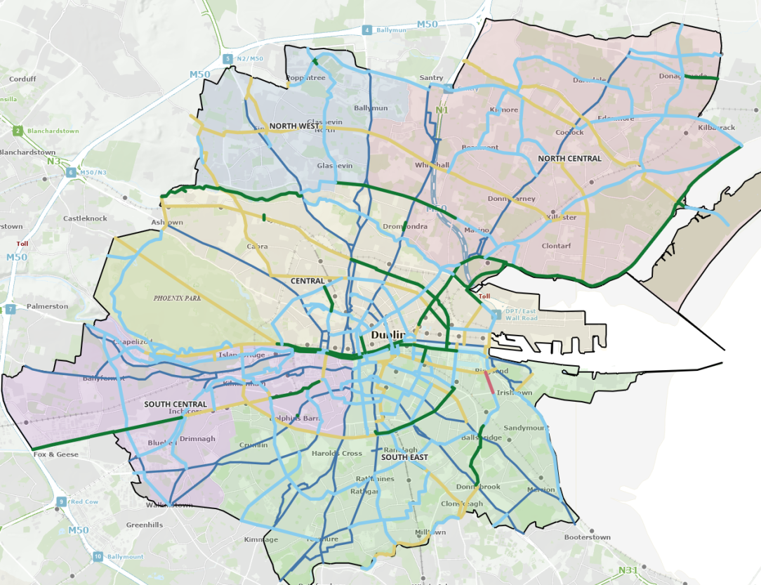
Riddlin, some updates I can see for your map on Post 1.
In the Barnhill area of Clonee, the new road scheme is complete so cycle lanes have now been provided here.
The protected cycle lanes on Castletymon Road in Tallaght now extend all the way from Greenhills Road to Castletymon Library
In Kerry, two parts of the South Kerry Greenway marked in green on this map are open.
Updated, with thanks!
A key missing scheme in south Dublin is Portobello-Suir Road. This is to be provided as a Portobello-Blackhorse scheme, with the website here.
Just a suggestion but you might want to add that link to the route in the map.
from that link, spot how much of the cycle network is currently "under construction" (it's the bit in red, and actually it's pretty much built). As with all things transport related, we're world leaders at drawing lines on maps…
That is so poor. So much planning and such little actual work.
I thought Dublin was ahead of the curve in compariosn to the rest if the country! clearly struggling also.
I just think it makes sense to invest in an urban area like this, connect people, places, schools, work etc
whats worse is that this network was first drawn up in 2014, so that's 10+ years of non-progress on that map.
Green is complete, Yellow is "in planning"; light blue is [waves hands vaguely] in the future; dark blue is BusConnects.
In that map, Chesterfield Ave should be green
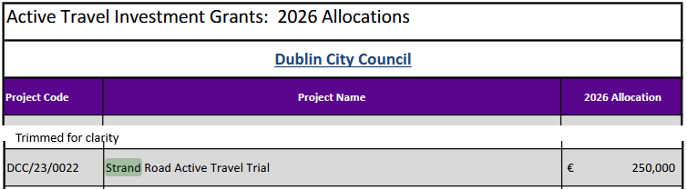
Wasn't sure which thread to put this in, potential Strand Road Trial update, which would be very welcome. In the Dublin City Council Capital Programme 2026 - 2028 (Available in the Resources tab of an upcoming Council Meeting and Directly Here ), It's mentioned on p30 in the table breakdown of expenditure / income, and then again on p38. p30:
p38
Does anyone know if the Council are looking to again proceed with this?
I've looked back at the past few year's NTA AT allocations and this year 2026 represents an increase: 2023: 100,000 2024: 100,000 2025: 50,000 2026: 250,000
what have they been spending the previous years allocations on, given that there has been nothing happening at all?
If on the map in post #1 Capel St in Dublin is shown green as it is pedestrianised, so should Parliament St.
Updated with thanks! As a general rule, I'm usually quick to update if it's pointed out so if you see any thing out of date let me know!
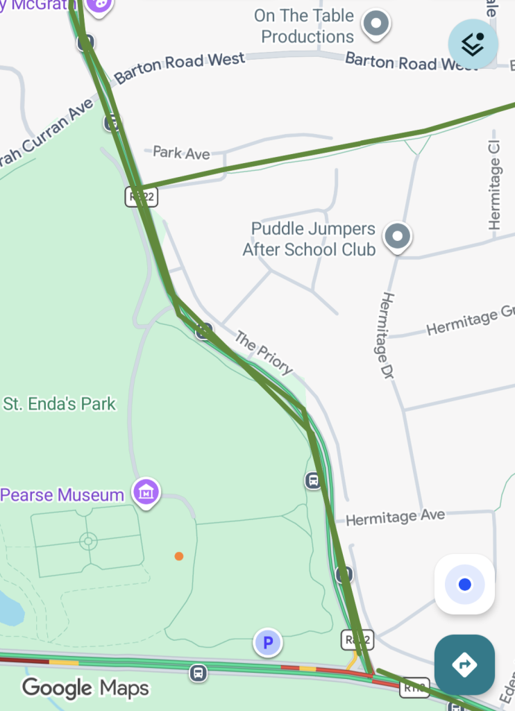
There's a section here in South Dublin between Barton road West/Sarah Curran avenue and Taylors Ln/Grange road that's mistakingly marked as Greenway despite no cycle lanes (though it easy enough to use the quiet housing estate roads that run parallel to the busy narrow main road).
https://maps.app.goo.gl/c7C6ki2fBZuLwCVHA?g_st=ac
https://www.echolive.ie/corknews/arid-41829164.html
Has anyone heard anything about this? Are the Echo just butchering the reporting (like they did with the new Luas route) or is there a serious push by the council to run buses on the greenway itself?
Maybe they're planning a fleet of those hen night pedal things you sometimes see around towns.
The headline says "on", the first paragraph more correctly says "along".
What is the distinction? How can you run a bus along the greenway without going on the greenway? There are already buses travelling the N25 route from Midleton to Youghal.
The mere existence of that greenway really makes some councilors soil themselves in a fit of rage.
Looking at the wayleave boundary on the property folios, there doesn't appear to be sufficient space to accommodate the greenway and a bus corridor - not without CPO-ing farmland all along the route.
Definitely doesn't make any sense. My guess is an additional bus route that runs from the train station in Midleton to Youghal and potentially stopping in likes of Mogeely and Killeagh.
”Along the greenway”, the wording in the article, allows for a road to be build alongside the existing path: it’s on the route, but perhaps not on the greenway path itself.
“On the greenway”, from headline, implies that the existing path will be replaced with a road.
The first sounds like the words of a planner, the second sounds like the words of someone looking for a shock headline.
Building an entire road just to accommodate one bus route also seems quite crazy. Might as well just build the rail line at that rate.
Seems a little odd for Wexford County Council to try and encroach on IrishRail lands when alternative routes exist. Good they seem to have found a solution though.
From looking at the preferred route, I assume very little Irish Rail land would be used for the Greenway. Just a couple of metres wide along the rail line which would be of limited use well away from main port operations. They should have to show how the Greenway could potentially negatively impact them, not just throw out these dramatic general statements.
They have a full Master plan which is being implemented at a cost of billions, when that is completed, there is unlikely to be major changes there again this century. If that land isn't identified for a particular/potential use under the Master plan (I don't know if it is or isn't), then they can hardly complain about "sterilisation". Even if the Greenway wasn't CPO'd and was only made available until such time as Irish Rail actually need it.
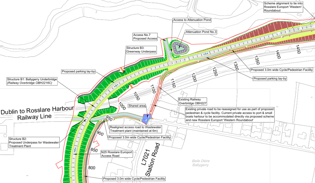
It looks like the Greenway is intended to use an existing old bridge to cross the rail line which makes a lot of sense in terms of reducing cost and preserving railway heritage. I'd be annoyed if the alternative solution meant that bridge can't be used and a new bridge had to be built to accommodate the Greenway.
Conveniently the tender was published yesterday for the Rosslare Europort Access Route, so I looked into this further.
The existing bridge which I mentioned is to be repurposed for active travel. There is also an underpass provided specifically for the Greenway (Structure B3) so IR should be told "that's where the Greenway is going and that's that". There will minimal space between the sea and the road once it is built and it won't be usable for anything else. IR should be grateful for the huge investment which the government is pumping into REP as they have done nothing with it for decades. The least they can do is spare a strip of land for a public Greenway
Preferred route corridor published for 4 greenway projects in Donegal
https://highlandradio.com/2026/05/26/council-publishes-options-reports-for-four-greenways-in-donegal/
PDF publication:
https://highlandradio.com/wp-content/uploads/2026/05/Greenway-Project-Options.docx
Burtonport-Letterkenny if delivered in full will be of huge length, 100km, and will join a ~25km existing cycleway alongside the improved N56 down to Glenties.
Seems to not subsume the trial section of railway to greenway conversion done a few years ago oddly, but go North of it. Options report is an absolute monster of a file and it's too hot to be digging through to see why!
edit: wasn't too hard to find, it goes North to get Dunfanaghy in as a major trip generator basically. Runs along the road for a lot of that so I suspect they'll be really really hoping TII decide to do a Type 3 SC upgrade and save the money coming from active travel or tourism budgets! Railway line for most of the rest of the way.
Will also follow the Gweedore Canal - the diverted waterway for the hydro plant.
Could easily see a future railway direct route being done as well.
BTW the cycle path on Griffith Avenue, Dublin is “complete”. The section between Philisburgh Avenue and Malahide Road. It has been “complete” for a few years now, but I just noticed. I say “complete” because it was supposed to be only a quick build temporary cycle lane, but it took years to complete and there is no sign of a proper long term solution. The cycle lane is a pretty poor design and certainly not fit for its primary purpose of children being able to safely cycle to school. A real pity as this road had plenty of space to do it properly.