BusConnects is a good example of this - yes it will provide safe and mostly continuous cycling routes into the city, but anyone who already cycles these routes will find their journey a lot slower as they'll be expected to wait for bike-specific signals at many junctions where general traffic will have priority.
I agree mostly with what you say in your post, but just on this point. With the new Clontarf to City Center cycle lane, I notice that most of even the sports type cyclists are using it and I see almost no one using the bus lanes now. I'm sure there are a few, but far less of them then in the past, with most in the cycle lane.
And that was very much the case in the older Clontarf to Howth cycle path too, large numbers of fast confident cyclists on the cycle path and you would be shocked to see one on the road next to it.
I suppose the point I'm making is that it depends on how good a cycle path you create, the better quality, longer distance ones even very experienced cyclists are happy to use.
Sure you have to deal with and carefully overtake slower cyclists, but it beats getting stuck behind buses stopping at every stop, etc.
For BusConnects I'd guess it will depend on the route in question, some are being designed to a higher quality then others. There is also an element that you might use some of it and switch to the road at other parts. Take the Malahide Road BusConnects plan, most of it is great and I can see most experienced cyclists using it, except for the bit between Griffith Avenue and Fairview where it stupidly goes off down Brian Road. No experienced cyclists is going to bother with that detour and instead they will continue down the bus lane to Fairview.
Yep I'd typically be a "faster" cyclist let's say, and I use a good bit of cycle infrastructure now. It doesn't really matter whether I'm training or commuting, I'll often accept the inconvenience of slowing down for the "dog slalom" if my overall journey is faster/more consistent.
I'm fed up of telling designers that if they design it right, everyone will use it. Existing cyclists' opinions can be valid too when it comes to cycle infrastructure, particularly where there's already lots of cyclists using a route. Too often they're designing for 12kmh and assuming we won't use any cycle infrastructure, and that's really just not good enough in my book. They need to be designing for 30kmh (or even more!) in some places. Designing for everyone
Yep, same mistake being made as part of the CBC to Tallaght. True crime, they won’t provide cycle lanes and cyclists have to go down St Mary’s Road and Bunting Road. No cyclist is going to do that when it’s a detour.
TII Greenway/active travel allocations for 2025 are out (67million for Greenways/active travel)
https://www.gov.ie/en/press-release/56648-67-million-for-irelands-greenways-in-2025/
I believe 2024 it was 72million, not clear if this is due to what stage projects are at or if it's new minister changing priorities
Update for Eastgate, Little Island, Cork: construction currently underway. Bus/bike gate at the West being constructed right now. No map change required yet.
Update for Cork City North: Cork Northern Distributor (3.25m 2-way cycleway each side) currently at corridor selection. Not quite a greenway, and not directly connected to greenways so maybe not an update for this greenway map? Details here: https://www.cndmrpublicconsultation.ie/index.htm
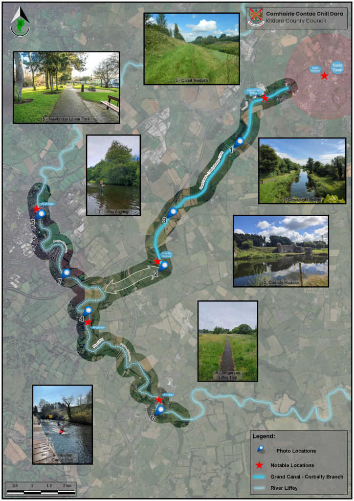
https://kildarecoco.ie/News/KildareCountyCouncilAnnouncesEventforCorballyCanalLiffeyCorridor.html
Passed by the Royal Canal Greenway in Maynooth earlier today. There doesn’t seem to be too much left (to my amateur eyes) before the section from Maynooth to Pike’s Bridge (Carton House front entrance) will be able to open.
Spotted this planning application noted along grand canal greenway near edenderry. Considerable plans by BnM to link canal to some old railways and windfarsm https://offalycoco.eplanning.ie/idocsweb/ViewFiles.aspx?docid=246226&format=djvu I had hoped for more expansive links south towards poartarlington and north to royal canal.. This is just fitting greenwas to existing infrastructure, it doesnt do anything to improve links to nearby villages.
It seems to have been a month ago when it was discussed by Kildare CC but I'm only seeing it now.
At the meeting, he motioned for Kildare County Council to provide "an updated detailed plan and timeline for the completion of the Grand Canal Greenway from Sallins through Robertstown, Allenwood, Killina and Ticknevin, to Edenderry, following the allocation of a €4m investment by the government".In response to his motion, KCC presented a lengthy report to Cllr Wyse and the other local representatives: "[The] Grand Canal Greenway Ph2 - Sallins Tie-in will be issued for tender Late Q2, six-week tender return period with an intended construction start date in early Q4 2025."Waterways Ireland to deliver a section of the Grand Canal Greenway from Clonkeen through Ticknevin to Lowtown."KCC continued: "This package is intended to proceed to construction in early to mid Q3 2025. ADVERTISEMENT - CONTINUE READING BELOW"The above contracts 1 and 2 will be delivered through the allocated funding."Contracts 3 and 4 (remainder of the works) will be issued for Tender from 2026 onward with more precise timelines at a later date depending on funding allocations and resources etc."KCC further said that the third and fourth contracts will require the completion of three main elements.These elements are: additional environmental reports at Shee bridge for Mid Q3, 2025; the Part 8 advertisement of the additional pedestrian bridges at Lowtown and adjacent to Healys Bridge / Bonynge Bridge to be advertised late Q2 2025; and the completion of a junction safety improvement at Ticknevin junction which will the completion of a Section 38 Safety Improvement process.
At the meeting, he motioned for Kildare County Council to provide "an updated detailed plan and timeline for the completion of the Grand Canal Greenway from Sallins through Robertstown, Allenwood, Killina and Ticknevin, to Edenderry, following the allocation of a €4m investment by the government".
In response to his motion, KCC presented a lengthy report to Cllr Wyse and the other local representatives: "[The] Grand Canal Greenway Ph2 - Sallins Tie-in will be issued for tender Late Q2, six-week tender return period with an intended construction start date in early Q4 2025.
"Waterways Ireland to deliver a section of the Grand Canal Greenway from Clonkeen through Ticknevin to Lowtown."
KCC continued: "This package is intended to proceed to construction in early to mid Q3 2025. ADVERTISEMENT - CONTINUE READING BELOW
"The above contracts 1 and 2 will be delivered through the allocated funding.
"Contracts 3 and 4 (remainder of the works) will be issued for Tender from 2026 onward with more precise timelines at a later date depending on funding allocations and resources etc."
KCC further said that the third and fourth contracts will require the completion of three main elements.
These elements are: additional environmental reports at Shee bridge for Mid Q3, 2025; the Part 8 advertisement of the additional pedestrian bridges at Lowtown and adjacent to Healys Bridge / Bonynge Bridge to be advertised late Q2 2025; and the completion of a junction safety improvement at Ticknevin junction which will the completion of a Section 38 Safety Improvement process.
https://www.kildarenow.com/news/local-news/1770602/4-million-allocation-for-large-scale-kildare-project-welcomed.html
Greenway works between Carrigtohill and Midleton definitely underway, I've been seeing some land clearance and some paint markings on the road.
Wonder what's happening with that little bit between the Elm Tree and Fota retail park. Seems to have completely stalled.
Are they putting a trail alongside an active railway?
Yes exactly.
Part of this scheme:
https://www.corkcoco.ie/en/resident/planning-and-development/public-consultations/closed-part-8-development-consultation/part-8-proposed-carrigtwohill-urban-regeneration-and-development-fund-urdf-initiative-urban
And part of this scheme:
https://www.corkcoco.ie/en/resident/planning-and-development/public-consultations/closed-part-8-development-consultation/part-8-proposed-carrigtwohill-to-midleton-inter-urban-cycle-route-phase-2
The latter (inter-urban…) currently seems to have paint on the ground from what I saw.
It's in a state of near-completion for a long time now. I wonder if the dualling of the Midleton line has caused them to pause the greenway. It's such a short stretch though, it's very hard to understand.
These were taken back in mid-March, there was hardly any progress on the Elm Tree side for quite some time. Saw more happening from the Fota Retail Park side but it hasn't been fully tarmacked yet when I last observed the path from the train (6th April). It looks to me that the work is more focused in the area close to Carrigtwohill train station at the moment
Yes that's my most recent view of it too, your photos capture where it is now still as of a few days ago. That first photo seems to be the main blocker. Some materials are laid out there just out-of-shot and they must surely have a technical or resource issue of some kind.
I still don't know for sure whether the lads working around the station are doing the track doubling or the greenway or both. There has definitely been land clearance and road measurement marking done for the greenway though, particularly around the train station area.
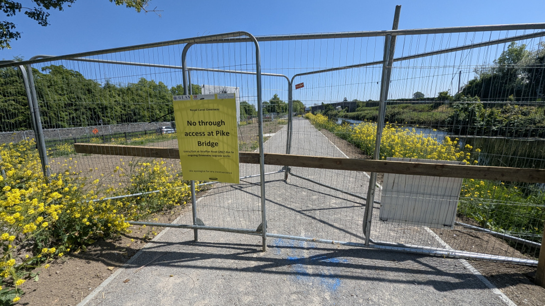
Looks like the Royal Canal Greenway is open now from Straffan Road in Maynooth to Pike’s bridge (front gates of Carton House).
Updated on the map, let me know if there's anything else needing updated!
Getting close to finally bringing the royal canal greenway to Dublin.
The Maynooth end is open, tarmac for the first 500m the gravel as far as…. 50m short of Pike's bridge!
R
Thanks for that.
Only went by in the bus yesterday! Will wait til it’s open a bit fitter befire joggin down that way so!
Is the work there going beyond Pikes Bridge to Deey Bridge do you know?
That is just a straight shot section to fully complete the route as far as Leixlip so I can't see why there would be any hold up on it other than just the last bit constructed?
The work is going on to create a road-side cycle track between Pike's Bridge and Dee Bridge, with some work on the towpath for pedestrians. Some of the stretch of cycle track is completed, paved but not painted, but there's a couple of months work left to do. There's no work left on the Maynooth side of Pike's Bridge other than to remove the barriers.
Along the canal requires final surfacing, lighting and other finishing touches.
Along the road part requires integration with the canal side and also fencing to stop cars being parked on it.
Anyone know what's the craic with the proposed Mallow to Dungarvan Greenway. Has it any chance of happening? As I understand it most of the rail line between Mallow and Fermoy is intact however between Fermoy and Dungarvan the line is largely gone. There's loads of signs up in the Ballyduff area against the proposed Greenway and one particular farmer near Cappagh Co. Waterford is doing the same. Opposition from landowners along the Waterford section of the route is formidable.
It would be an incredible resource with absolutely stunning scenery as half of the proposed Greenway would run along the Blackwater valley, include picturesque towns like Lismore and end up at Dungarvan where you could continue on to the Waterford Greenway if you so wished.
I believe the council is just at route analysis at the moment. The bit between Mallow and Fermoy would definitely be the top priority for me.
the opposition is hard to understand when there isn't even a proposed route, like what are they actually worried about?
Other greenways around the country have been very successful, brought in tourists and supported businesses in areas that were previously fairly dead. Have these people never been more than 10k from their homes?
Most of the protesters are farmers who don't want to give up land or have it bisected by a Greenway. Some residents along the route are claiming it'll run along the back of their gardens and one claims it'll cut his driveway in two.
If a route has yet to be proposed then a lot of these concerns may go away when it is, if it is, proposed.
Very likely people along the route have checked the route of the old railway/know it went over their land and are freaking out.
Not to accuse planners of an overabundance of sense but they might prefer a route that doesn't cut someone's driveway in half just to keep rigidly to the rail line.
Opposition at present can probably be divided into:
Some of the old route is still there, but it's not particularly high value as a greenway. I'd suggest that the Cappoquin, Kilcummer and Fermoy bridges are reasonably high value and should be kept on the route if possible. Plus a reinstatement of the bridge link over the current N20 to Mallow Train Station would be great. Other than that, just routing it near the Blackwater would be fine.
I'd also be inclined to think that routing from Youghal to Cappoquin through Vilierstown, and then East to Dungarvan could be a better link for Cork-Waterord than following the N25 East through Ardmore etc.
But overall I don't see Fermoy-Dungarvan being as high a priority for active transport as Mallow-Fermoy. Even just the greenway around Mallow itself would be the highest priority I think. All greenways are good, obviously, but I don't see huge value in slavishly following the route of an old railway if it doesn't particularly connect anything or doesn't contain any significant areas of beauty. Hugging the blackwater would at least get you areas of beauty. You could probably tie flood relief works into your greenway works too.
The old railway routes are usually flat and straight
Detours to facilitate landowners are often dog legs and undulating