As suggested in other thread, starting new thread, to continue discussion, and reduce the issue of 'Vanilla Tremble' (…another great new Boards feature!!!).
After event, will merge threads.
Poor dog, you would let her sleep outside in this weather?
-2 in D10 according to my phone, dunno if that’s legit? Didn’t think Dublin was to get as cold tonight. Frost on cars & the path etc. Baltic 🥶
Dublin airport and Casement both -1°c at 10pm, so not far off.
I suspect a WUM. @DellyBelly
Has been since part 1 of the thread. And during many other events on here before. Nearly consider them a regular at this stage.
-2 in celbridge. Foot paths arent great. See a lot out doing their walks. Madness.
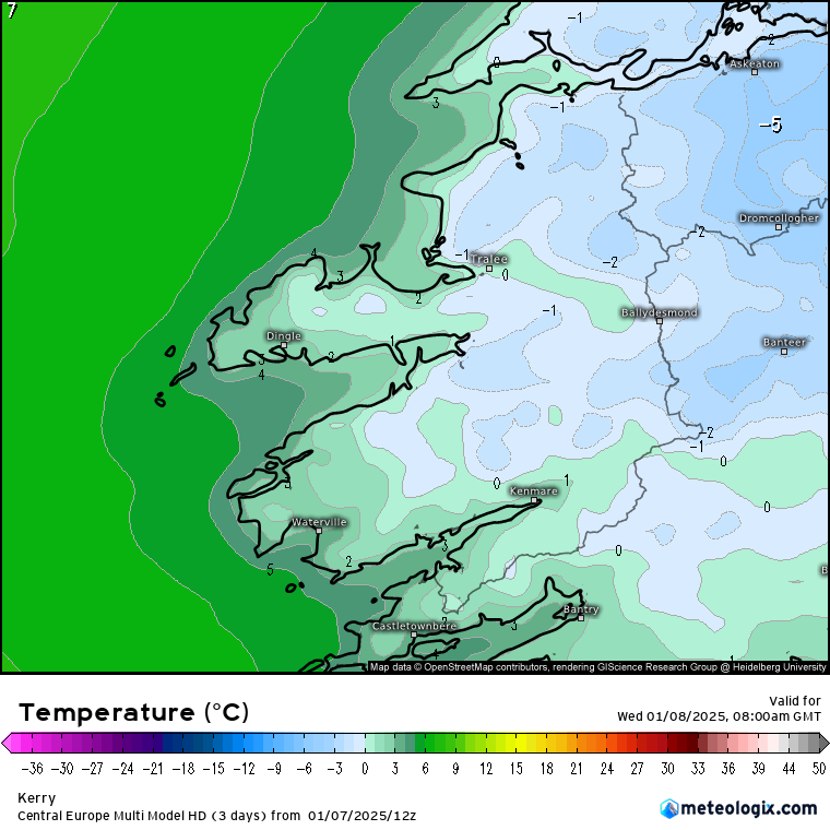
Temp here near the Kerry coast -0.5C. Was out a short time ago putting some insulation around a pipe and had a few drops of rain. There is a fine glaze over the yard after todays snow melt and numerous wintry showers which were mostly rain with a bit of hail or sleet mixed in. Will be reviewing early if safe to get into work in the morning. I have a feeling it will get down to about -2C here .
Noticed a big spread in temps too between the models, keeping an eye on the two multi models, a combined Hi res and combined global. Both showing about -5C as the average lowest temp, -4C more widespread, showing about -1 or -2C here in Kerry for my morning commute in Kerry. Will see how it performs, probably get a bit lower locally, they did well for the snow coverage.
For eejits like me - WUM = Wind Up Merchant. You’re welcome.
Really?
My barometer is saying +0.9.
That's Wilton/Bishopstown area.
11pm
Athenry -3
Oak Park -3
Mount Dillon -2
I nearly felt sorry for sending the wife walking the 6km into town tonight for a few packets of honky dory’s.
Nearly.
My little wether station is reading -2 in Naas. In not sure how accurate it is. I could hear the grass crunching under the dogs feet when she went out.
Nothing on the 11pm reports that warrant an orange warning imo. Across Cork City no lying snow temps hovering around 0C and yet all schools are shut until 11 tomorrow. Cork City has hundreds of schools and with a veil of cloud over us I'm certain temps will not drop much more..
I'm sorry but attention to detail is required by Met Eireann for large populated areas!!
M8 I got a day off school for this, I hope everyone knows it’s an historic event
Going on the 11pm Met Station temps, -3c being the lowest, there's a bit to travel to -8c.
11.30pm now so 9 hours until 8.30am. Plenty of time for dropping.
I remember during Christmas week 2010 watching Stations hitting -10c at 5 and 6pm! That was an amazing month. I know I'm starting to talk about 2010 the way my late father talked about 47.
I suppose 1947 is the gold standard for snow.
1962-63 the gold standard for a severe cold winter with plenty of snow.
And December 2010 is the gold standard for the coldest month since the 19th century.
I look on 1982 and 2018 as week long huge snowfalls, but the lack of longevity puts them behind the big 3.
Nice Sat Pic from Copernicus of Kilkenny from yesterday . Tweaked the pic a tad with some photography editing software just to sharpen it a bit and bring out little bit more contrast.
https://browser.dataspace.copernicus.eu/?zoom=5&lat=50.16282&lng=20.78613&demSource3D=%22MAPZEN%22&cloudCoverage=30&dateMode=SINGLE
Maybe we'll get near minus 8 but minus 6 probably as low as we go tonight but a subzero day tomorrow followed by frost tomorrow may bring minus 8 or 9...unless the phantom highcloud comes to moderate it a tad. After Friday morning it's game over for January cold weather until perhaps the end or start of February. I'll be happy to get some mild days. Hate going out when it's cold and raining all the time.
According to the thermostat on the north face of the outside wall it's currently -1...that's assuming it's correct. The moon is slightly obscured by cloud which could explain why it hasn't reached -4 as per the forecast.
West Waterford
Maybe not the place for this. However. Ireland's Weather Channel has been forefront of recent weather events since snowfall in November.
In June 2020 the Channel drew up a purple and black coloured warning, above red. Thunderstorms of the Century were predicted, beating 1985. Laois and Offaly were to bear the brunt, a black warning. Not a rumble. I saved the chart.
The confusion this spreads among the public. The forecaster isn't bad if he toned things down. But messing with warnings is reckless.
It looked like the Black Death was coming to Laois and Offaly.
Gurteen and Athenry down to -4c at midnight, a few stations at -3c including Oak Park.
Could get down to -8c by dawn.
This band seems to be moving towards the south coast ...
A -4ºc in the south midlands and they gonna continue to drop as the hours go on
it’s moving NE
Sryan pointed out on his bingo card 'discussion of past weather events'.
Well here I go. 34 years ago today, 8th January 1991, witnessed a sleet to snow event across much of the midlands. It was a heavy fall, returning polar maritime air. 10 pupils were left stranded in the boarding school I attended. We played indoor football, basketball and watched videos until the wee hours. Myself and my brother were the last 2 to get home late on 9th January. Our dad came in and rescued us by tractor.
A bit like this year when that spell ended in 3 or 4 days many felt winter was over. However, 4-10th February brought Siberian winds and snowfall.
North Cork -5.4C https://www.wunderground.com/dashboard/pws/ICHURC28/graph/2025-01-8/2025-01-8/daily
Rosemount Westmeath almost at -5c https://www.wunderground.com/dashboard/pws/IMOATE2/graph/2025-01-8/2025-01-8/daily
Cloudbank looks to have stopped its march northwards and is now just drifting east. Should be some very cold minima as a result to the north of it.
I'll say of the officials; Gurteen -6.8c
Have you watched ‘The Holdovers’?
Has hovered around - 4 here n. Offaly since 1am. Fog has set in so probably freezing fog. May stop temps going lower.
-5 at Gurteen, MtDillon, and Mullingar are lowest at 0500h.


![Photo of [Deleted User]](https://wd.vanillicon.com/v2/d38dadd4e9049f636f3a15f844846484.svg)