As suggested in other thread, starting new thread, to continue discussion, and reduce the issue of 'Vanilla Tremble' (…another great new Boards feature!!!).
After event, will merge threads.
Can't tell if you are being serious or not.
The snow line in Dublin/Wicklow is around 200 m at the moment and quite sharp, which can be seen below from Tallaght, though there were some remaining patches of snow on the outskirts of Citywest. Blessington looks to have gotten around 5 cm last night but it's turned into a bit of a compacted slushy mess but still not too bad outside the village itself. I was hoping to get a photo of the view looking down on Dublin but was unfortunately roped into an unwanted conversation!
More sleet in North Offaly. A most forgettable spell for these parts.
Cold rain and 6 degrees here, iv never been so misled by a forecast like the one they issued last thursday. Above freezing by day and by night for the entirity of the cold spell, tonight they say temperature will be between minus 5 and 0, yet im getting a minimum of 4 with a stupid yellow hazzard sign, for what?
ill barely notice the change in conditions by the time we transition back to standard pig muck next friday, what a huge let down and atrocious inaccurate and misleading forecasting.
The lay by just down from Knock airport.
I would have thought you have been around the weather forum long enough and have more sense than to throw the toys out of the pram over some difficult to predict snow.
Slight thaw here before the next band arrives which doesn't look as intense.
Snow in south Roscommon/east Galway. And it seems to be sticking at the moment.
The kids were back to school today but mine have COVID so they are enjoying a bit of a snow day!
Based on the Arome model, there is a chance of a light dusting in parts of Dublin, with the exception of locations right by the sea perhaps, early tomorrow morn as sleet and snow showers extend their way down across the country from the northwest.
Cathal Nolan of IWC 😀 🙁 on Newstalk giving his expert opinions
More Sleet and snow forecast for this evening and an orange warning back in force tomorrow according to the lunchtime forecast
Heavy snow the last hour os so in South Roscommon.
Stopped now but likely to start again, its bloody freezing. Just lit the stove, cant bate a turf fire on a day like that.
Snowing again in Kinnitty, Co Offaly.
Condor, South Offaly is where it’s at!
Well he said red was warranted in those places that got plenty of snow. Maybe he's right but Met E are damned if they don't and damned if they do. I don't remember previous snow events, maybe Emma excepted, where people were so hung up on warnings and the colour of them. We're losing the 'dig in and help out' mentality here, the community helping out, it's all about blame and what'll we do lads nowadays...
WIthout wanting to derail the thread. Does he even give any criteria for his warnings? At least Met Eireann have strict criteria. Not saying that an impact based system would be better but at least it can be tailored to areas usual weather.
Last of the snow has melted here in Dunshaughlin with temperatures several degrees above freezing. This week is nowhere nearly as cold as what was being predicted last week. A few days ago they were predicting it to stay sub zero from Sunday till Friday and now +2 to +4 by day and fractionally below freezing at night for my location. This is why when it comes to cold and snow in the winter I look for those -10 uppers. Uppers between -3 and -6 like what we currently have thawing is always going to be an issue.
Stopped snowing 20 minutes ago. There is now a thaw underway. I expect the temperature will drop sufficiently after dark so that any snow then will hopefully start sticking again. Unless we get a pesky mild sector, which could happen with these troughs.
Ah for fecks sake it's starting to sleet/snow again. I'm sick of it.
N Tipp 1.4C falling
I Took a walk up the road here to where I can see across to the Sliabh Bloom mountains. Except I couldn't see them, so whether it's rain, hail , sleet or snow that's incoming, remains to be seen! Portlaoise.
The turn off to knock airport
Light rain at the moment in SW Laois helping with the thaw out, but looking at the radar heavier precipitation on the way which might turn back to snow?
Upper temperature wouldn’t have mattered that much for snow retention at this time of the year if the skies cleared quickly when the snow stopped in the evening and severe frost set in quickly. They wouldn’t recover that much during the day. That severe frost didn’t happen yesterday and with uppers being milder than first thought with cloud cover it didn’t help. Shower activity is also a lot more widespread than initially expected today.
To Be sure to be sure all PPN from East N East direction as well!
Now just raining in Killarney, not a snowflake in sight. Most of the snow will probably melt today, remains to be seen how much melts before a very cold Tuesday night.
I'm on the back road to Mountmellick , snow falling here now.
Travelling from East Clare to Galway city at 3.30pm. Whats the M18 like? Is the main Dublin Rd in the city ok to commute?
Funny, just started to snow here now!
True, considering what the models were showing in the lead up to this, I did not expect to be worried about thaws this week. I suppose we are long enough in the tooth to know better but maybe when you are emotionally invested in something the heart can often rule the head. Perhaps it is just skewed perception on my part,but northerly airmasses these days don't seem as cold as they used to be or maybe I am just wrong about that.
Get out of here:)
Just wet in Galway, no accumulations or ice.
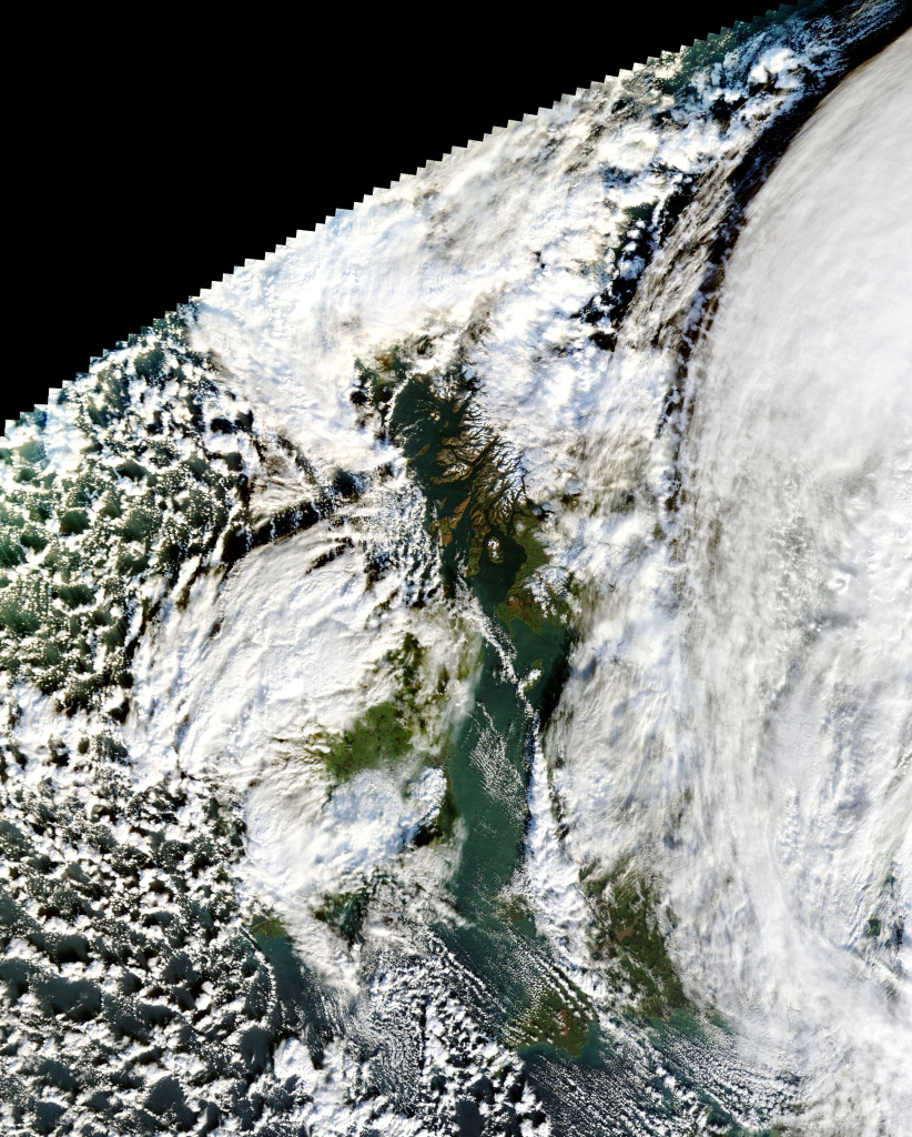
A NASA satellite image of Ireland and Britain at lunchtime today. A break in the cloud cover reveals snow covering large parts of the Midlands. Plenty of snow cover visible in Scotland too.