Thanks, could be that. I don't see boulders or stone piles anywhere around, but there's a little river there, maybe they'd use them along the river banks. I was looking at other pics where there were furze bushes where the circles are, but it's hard to figure if the circles could be a farmer digging out the furze roots and all, or if the furze was opportunistic and settled there after.
You're right about MMoore, he's on all the records, although there was a lady assigned to another area there too more recently. I emailed the NM records anyway, we'll see.
Hi again, do you see anything in this, and what could it be? Thanks
I feel like that's machinery derived, it closely follows the lines of the field.
I don't mean to abuse anyone's patience, but I'm in the process of looking and reporting monuments in an area, and I don't want to waste the monuments' services time reporting silly things.
Getting your feedback here helps me determine if I'm imagining things.
Do you see anything of interest in the image below? You will probably need to enlarge it. Thank you!
It’s not the clearest image tbh. Have you tried Google Earth Pro? It’s higher quality, free and you can use the time slider to view earlier images.
There might be a hint of an enclosure to the right of the crosshairs. In the greener area and within a possible return in a field boundary?
There are lots of animal tracks there which might give the impression of features
None of the images are clear. I've been using GeoHive, Historic Environment Viewer, Google Earth Pro, and I'm googly eyed looking at many features such as on this image.
If it's ok Slowburner I will PM you with images, I'm chickening out of putting too much online. I would not want to draw attention to the place if it is something, I'm in the process of reporting. I am hoping someone from NMS will contact me directly rather than the usual way of emailing.
Medieval Pottery Sherd?
I'm curious if anyone would have any thoughts on the pottery sherd I've attached below? It was a surface find on plough soil. My initial thought was that it is medieval in date, dating from the 13th to 14th Century? A Norman motte and bailey is situated 500 metres south of the findspot. However, a cursory look online has turned up similarly glazed pottery known as English Borderware (see attached images). The sherd itself comprises a buff-coloured fabric.
It's a long shot I know, but someone may have an idea.
English Borderware (16th Century):
It is definitely medieval and your initial thought on date is about right. External lead glaze and a sand tempered fabric with quartzite inclusions. You say it is buff coloured but it looks more reddish in the photos. If it was a light buff colour, I would say Saintonge but the reddish hue suggests Irish or British. I think it is Irish but need to do a bit of research
Thanks, slowburner.
I would definitely say a light buff or cream-coloured fabric. I took the images in the absence of sunshine this evening. It doesn't really have a reddish hue as the photos would suggest. I'll take a couple of photos tomorrow in sunlight. Hopefully they'll give you a better idea of what it's likely to be?
Thanks again.
Saintonge pottery would fit nicely into the narrative with the presence of the Anglo-Norman motte and bailey very close to the findspot.
Here is a detailed view of the fabric of Ham Green ware. Broadly contemporary with Saintonge but with a coarser fabric and more frequent inclusions
Hi slowburner,
If that's typical of Ham Green ware, I'd be relatively confident the sherd I have is not Ham Green. The fabric is far too coarse, and the colour is not right either (the Ham Green is far lighter in colour). I'll do my best to upload images at lunchtime.
More images of the pottery sherd:
Hi folks,
Just came across this forum and thought I would share. While out hillwalking I came across this stone [headstone?] with what appeared to be some rock art [cupping] and other stones around - it looks like a grave. I said I would share on here to get peoples thoughts before I report to Monuments. There is nothing in this area in the Historic Environment Viewer but there are other rock art, standing stone and a crannog in the locality. Appreciate any comments / feedback.
I'd think that is indeed worth sharing, I feel there's something there but I find it harder to tell from photos than some of the more regular posters here
The largest stone does seem to have some potentially interesting linear marks. I would prefer not to get your hopes up though: they could easily be plough marks.
The hole is far too circular to be ancient unfortunately. It is more likely to be a 'spud stone'. These were sunk into the ground with a hole bored to hold a pivot for a door or gate.
The other stones appear to be part of a low wall and are not ancient.
Apologies for bursting bubbles but thank you for sharing. It would be good to see a clearer photo of the probable spud stone that shows the linear marks.
Hi Gremlinertia and slowburner, thank you for getting back to me. It is great to get your knowledge. I never heard of spud stones or plough marks so it is a good insight. These stones are located a long way from anything so to even think someone was working the land a way back is cool. The next time I'm out that direction I will get clearer photos. Thanks once again.
This 'stone' was found a few years ago around a field entrance and has been lying in a toolshed ever since (hence the paint splatters).
Any idea if the markings are natural or manmade? If manmade, any ideas what It might be? There is a 'circular enclosure' marked on archaeology maps nearby.
Could it have been used as a firestarter, where you'd put tinder in the hollow part and set it on fire by rapidly rubbing a "spinning" stick?
It was my first thought aswell
Would someone like to hazard a guess as to what this feature may be on these satellite images?
https://earth.google.com/web/%4053.20493947%2C-6.82614122%2C92.30292623a%2C1725.28301589d%2C35y%2C355.39844397h%2C0t%2C0r
https://www.bing.com/maps/?cp=53.204362%7E-6.82296&lvl=16.0&style=h
An ecclesiastical settlement or a rath or ringfort surrounded by a large earthen enclosure? The outer enclosure measures approximately 400m in diameter, so quite a substantial feature. It may just be modern field boundaries causing a trick of the eye? The cropmarks at the centre are at the highest point at an elevation of 94m, and the land slopes gently away to the curving boundaries. It's not on the National Monuments database of recorded monuments, and early OSi maps show a curvilinear feature at the northern edge only. Any ideas?
Can you post a screenshot or long and lat? Links are not bringing me anywhere, at least on my phone.
Hi Gremlinertia,
Here's a Google Earth screenshot with Long. and Lat. in the right hand corner.
This curvilinear feature lies one kilometre southeast of the bog body find at Baronstown West. This bog body, dated to between 200 - 400 A.D. is on display in the permanent Bog Body exhibition in the National Museum.
Info. relating to the bog body find at Baronstown West, Co. Kildare (click on the screenshot for a larger image).
The northern boundary appears to be a drain and is a feature that separates the bog from pasture rather than a feature that constitutes an enclosing element.
The southern 'boundary' is defined by a road that was quite well populated, probably until the Great Famine.
I don't think we are looking at a large enclosure. I think the overall morphology you are seeing is created by eighteenth century field systems, drainage and the road. The crop marks in the centre appear to be a field with drains. This field could be a booley field. There are some potentially medieval field boundaries in the southeastern quadrant and southwest of the road too. I think this overlay of the first edition map makes things pretty clear.
If there was an enclosing element to the west (red dashed line) you would expect to see some sort of a curvilinear crop mark. The crop marks visible at that location on the 2018 GE image are straight and are the remains of nineteenth field boundaries. The little dot in the field second from left (top) is a trigonometric point.
Interesting and good on you for looking
Thank you, Slowburner.
Extraordinary and fascinating that you could read the landscape like that. I guess I now know it's nothing to get excited about!
>deleted <
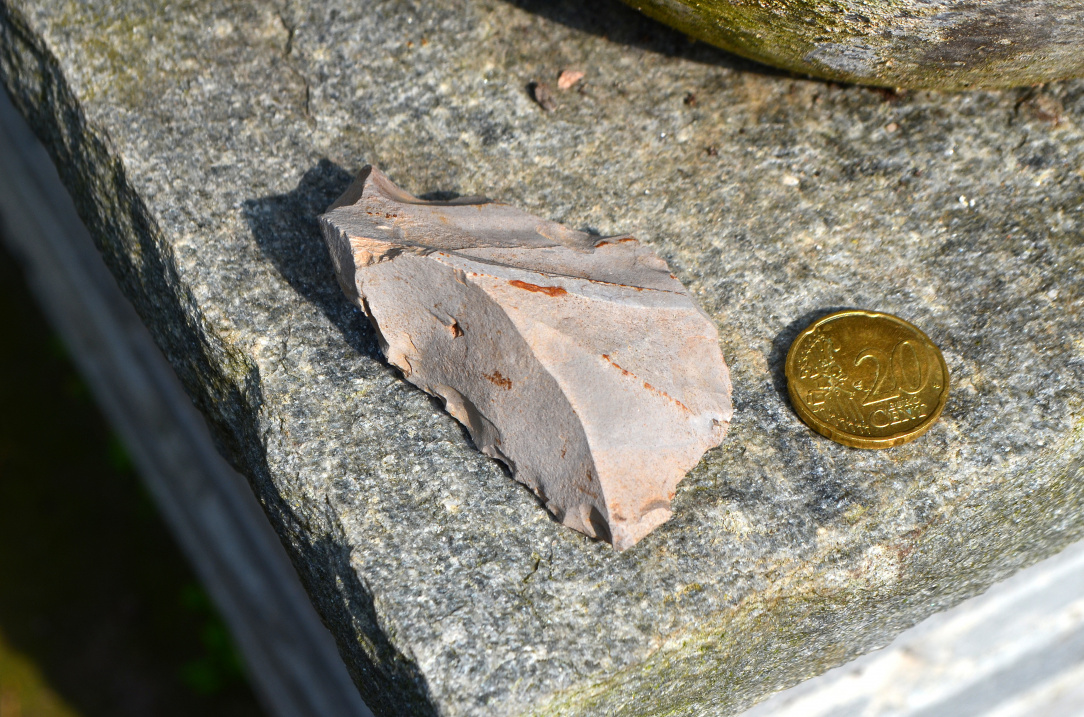
Does this look like a Porcellanite flake?
Certainly looks like it. It’s a strange one though: it looks more like a core than a flake. There are some indications that flakes may have been removed from the chunk. This might be unusual given that porcellanite is typically associated with axe production. You would expect waste flakes from axe rough-outs to be more substantial/clunky/amorphous and without primary reduction. I don’t know if porcellanite is a suitable lithology for stone tools - it probably is - but I can’t think of any southern Irish examples offhand. Might be worth getting in touch with the duty officer of the NMI and giving them all the usual details