Does this look bad this far out?
The link is here ... 09z (10h) data suggests eye of Agnes is over the buoy, pressure report is 969.8 and a south wind of about 18-20 kn. Site lists location as 51.0 N 13.55 W so that is also location of low centre give or take a few k.
Guidance generally had 973-978 pressures at this hour, so Agnes is stronger near its core, whether it affects larger scale forecast not yet known. It's acting a bit like a medi-cane (mediterranean subtropical low).
A great read if you have time
The rain in Rathdrum Wicklow is much heavier than forecast. Absolutely bucketing down here
Rain rate of 30.6mm/hr in Arklow with a SE wind gusting to 53kmh currently looks like a monsoon
Quite Vile out there now
For such a majestic light house and it’s history they should put in a webcam.
It seems to be getting a quite a bit rougher in Cork City now.
..
Moderate to Heavy rain in Kildare now
And there’s a storm coming too.
Flooding in waterford city
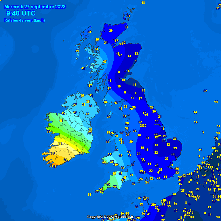
45kts / 83kph recored at waterford airport at 9am
Fine, I won't post again. I was only reporting a dramatic pick up in winds in a major city on a weather thread! It had been fairly moderate for the previous hour.
Raining here since the early hours, Portlaoise, now getting heavier.
Seems a bit calmer here now, had some very strong gusts for the last hour or so. Not looking forward to going into work later, have to drive though a heavily wooded valley alongside a stream as soon as I leave the house.
Lissarda, Mid Cork.
To be fair, you walked into that one! But the weather is certainly getting rougher, I will grant you that.
Multiple reports of trees down in Cork city.
Was the storm that hit Greece and Libya a few weeks ago with very heavy rain a medi-cane?
My weather station in Cork south suburbs. Pressure falling like a stone. Actually getting a headache...
Winds very much on the up again in cork City. Drains starting to get blocked from the leaves being blown off the trees
Wind picking up definitely here and rain coming down heavy again
Ramping up a bit further now in Greystones. Heavy driving rain and gusting 40kts now.
Picking up again in Waterville now.
06z GFS has better initialization and accurate central pressures now, showing a much stronger gradient about to move into west munster. Will be very rough conditions around noon to 2 p.m. across region. Also keeping an eye on squall line for any specific threats, over east munster into south Leinster.
Ramping up here significantly the last 20 minutes in Dublin 4. Heavy Rain and wind.
Looks like a squall line formed
The ultimate wind tracker. ESB outage map. ;) Thankfully not too bad so far.
It looks like a squall line passing over us here on the R600 (Cork to Kinsale) direction.. 11:00h
Rain stopped for enough time to walk the dog - West of Galway.
This site is proving pretty accurate if you want to know how much more rain is likely. Looks like most of the rain has gone.
https://www.weatherandradar.co.uk/weather-map?center=52.8,-11.68&placemark=53.2724,-9.051&zoom=6.42&layer=wr
Very windy here in Fermoy, not pleasant being outdoors, like a winter day walk on the beach, a bit of leaning into the wind. Large wheely bins on the move.
Wind picking up now in Dublin 5
I’m glad it’s not bad where you are and that you have the flexibility to decide whether or not to go into work - not everyone does. There are numerous reports of trees down and flooding around cork. Judging by my commute this am the commute home will be flooded. I had intended to try the alternative route but cork safety alert is indicating that there is a tree down. While I appreciate this may not be armageddon it does impact on those who are in the worst affected areas which thankfully for you does not include the west.
I hear around Tinahely/hacketstown the rain is torrential and wasn't expected to be as heavy.


![Photo of [Deleted User]](https://wb.vanillicon.com/v2/b1aba361f5b77a8017be035a0d4fc285.svg)



![Photo of [Deleted User]](https://w9.vanillicon.com/v2/9429a6e87ca90295fb14e1083556c0c3.svg)


