Does this look bad this far out?
Yes but with it falling under the radar with the media they will be unaware of any dangers. It wasn't even on the headlines with the.
That's a lovely looking spot for a sit down or play football with a child etc.
That's cause it doesn't affect the Dublin area.
I think the Southeast and East will added to the orange wind warning in the coming hours.
Not sure if it's a change of mind or just concern that some coastal areas could get quite badly hit even if orange verifies for most of the population, after all not that many people live on exposed coastlines for a good reason. So for city of Cork orange level warnings will likely be good, not so sure about Kinsale or other fully exposed locations. We have the luxury here of speculating about parts of counties in different levels of warnings, but my understanding is, if any part of a county is expected to "see red" then the warning for the county is red, I guess this is fudged to some extent for outer coastal fringes, but it only takes one gust to invalidate a forecast especially if that gust brings down a large tree or does structural damage. Also we need to be conveying the idea that airport weather stations are not always going to catch the strongest gusts in a storm, an embedded cell in a squall line could go between two stations and do more damage than the post-storm data might lead a person to expect. ... I agree with your comments in general, by the way.
I hate when these threads get to the point that a death toll is predicted and almost wished for in order to prove a point (e.g. MetE are crap, Warning system is crap, people/schools are stupid etc). I'd much prefer to just anticipate and experience the weather event. Roll on Agnes. Stay safe Ireland.
Cork airport TAF have forecast gusts up to 60 knots from the south around lunchtime. Thats fairly rough
TEMPO 2711/2713 17032G60KT
The usual warning ... if located in wind warning areas (orange-red) take a look at parking location for vehicle(s) and ask yourself, if nearby trees fell towards north in a southerly gale, to northeast in a s.w. gale, would they hit this vehicle? (or slates off a roof) ... if so, change parking location to a safer one. Save yourself a repair bill.
All trampolines and garden furniture should be safely stored now. (only partly facetious)
It's always the way with a weather system like this somewhere someone will ignore the alerts and warnings thankfully its seldom someone gets hurt and even rarer someone dies but these events are real and the warnings should be observed.
Stay safe and get somewhere warm and dry.
Shannon max gust 50 knots
Dublin max gust 47 knots
Knock 42 knots
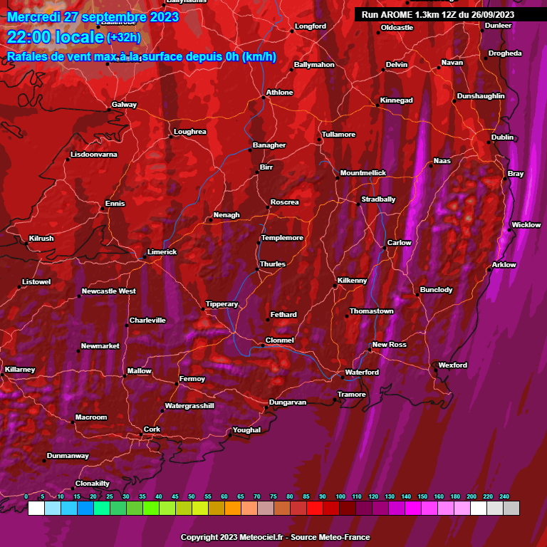
ECM still keeping things well within yellow parameters in the east. I know it's not as high res as some of the models but beyond the immediate coasts and exposed mountain areas it's still showing 90-110 as far as I can see
Now I do hope nobody gets in any way injured but I always felt Agnes would kick Ophelia's ass. And it's looking like tomorrow might just be a kick ass storm. Mother nature unleashed
Met Eireann showing the Harmonie today, looks quite strong well inland up into Leinster too, unfortunately can only get this much available to the public ( unless someone knows another source ).
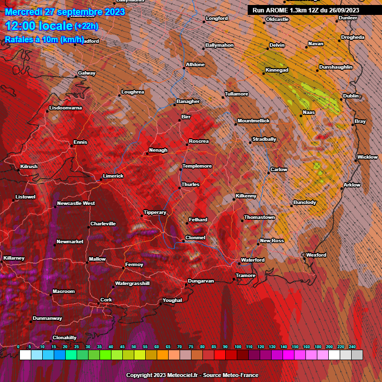
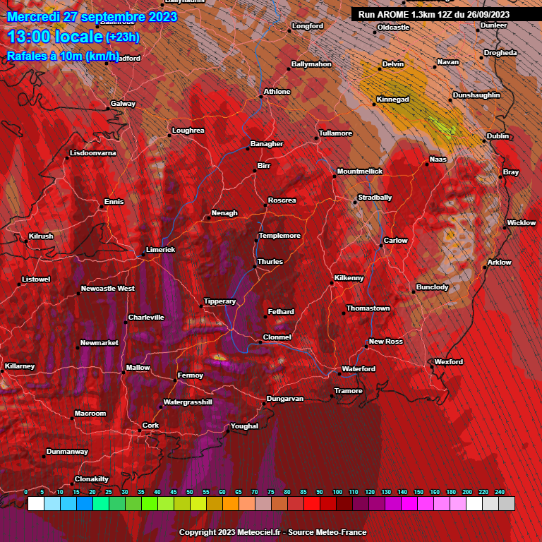
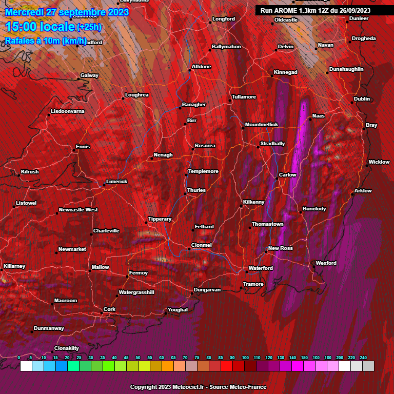
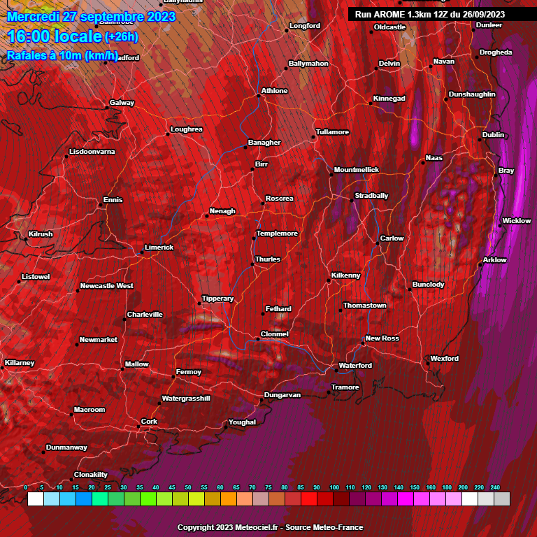
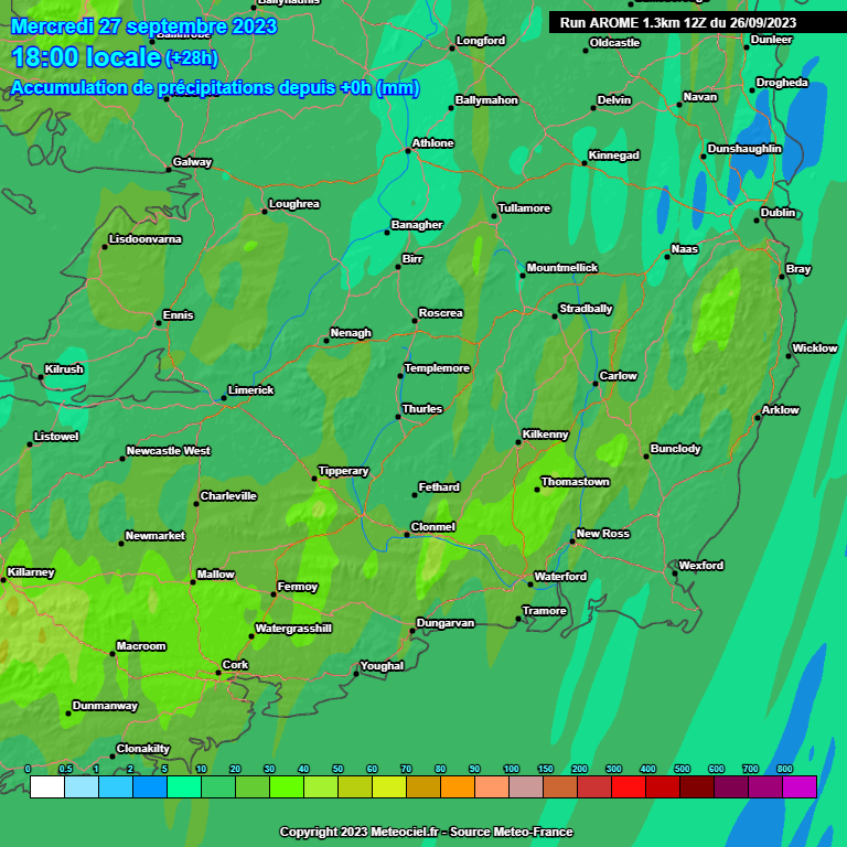
AROME good at picking out gusty winds, charts below not to be sneezed at, a good Hi Res model .Want to be careful on the motorways especially trucks etc.
As ever will see what the charts show later.
Thanks MT. Battened down the hatches here on the coast near kinsale. Its going to be a wild one!
Looking forward to your updates from the coast!
I think you're going to be very disappointed if you think this is comparable to Ophelia...
Great idea, interesting to see the results.
Indeed.
I spend most of my time in Portlaoise but I'm often at home, in Laois on the Carlow\Laois\Kilkenny border. The home house is 330m asl. The highest point locally is 339m asl. So that alone puts us in an orange category I'd say.
We get a lot of snow too.
There could be some floodin'.
What was your old username again?
Nagdefy
That's the one, recognise the homeplace location.
Big seas off the South coast tomorrow.
I think the elevation gives us a 20km per hour lift in wind speed. I worked it out once.
Remember the name too. We've been around this place a while. Is Su Campu still about or whatever his latest name was?
We're living 5km from the south coast in East Cork, could be a breezy day tomorrow!
Snowbie... I think
See these stripes in wind intensity, the upward pointing white lines in this model/projection.. would they be squall lines or something like that, or a modelling artefact?
Was Su Campu not involved in the aviation weather end of things?


![Photo of [Deleted User]](https://www.boards.ie/applications/dashboard/design/images/banned.png)




![Photo of [Deleted User]](https://wb.vanillicon.com/v2/b78264a0e13e5e3a27935691920a2390.svg)





