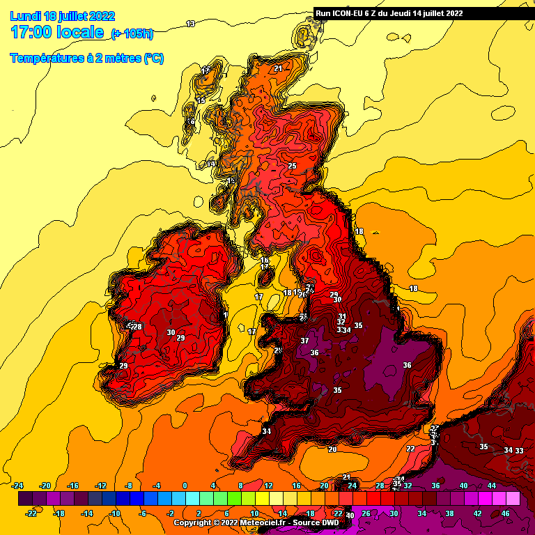
During the past week or so, the GFS has been hinting at some notable hot weather for Western Europe around the 15th July. Some runs had gone off showing ridiculous high temperatures getting widespread 40s into SE England and nearing 50C in southwestern France. For context, the UK record maximum temperature is 38.7C from July 2019 and France 45.9C in June 2019. The values on these GFS runs would completely smash these records to bits, similar to the Canadian heatwave in June 2021. Now and again, we've also seen the possibility of 30C or more being achieved in Ireland. The extreme temperatures being projected by the GFS have been pegged back a touch as time has gone on but only relatively speaking as records would still be tumbling or be vulnerable. The warm weather for Ireland meanwhile has only gotten more extreme lately with runs. It's not only the GFS doing this now, it's also the ECM, GEM and UKMO showing Ireland getting a direct feed by Monday 18th July. Details given below.
----------------------------
The latest ECM run as of writing this post shows an exceptional hot airmass reaching Ireland by Monday 18th July with 850hPa temperatures widely exceeding 20C. On the surface, such high temperatures aloft would usually correlate with mid to upper 30s but due to Ireland's maritime climate, moderation must be taken into consideration. Favoured areas such as inland regions would achieve over 30C. In fact, the raw ECM temperatures indicate values of 32C around Kildare/Dublin on both Monday and Tuesday. Much of the north Midlands and parts of Clare/Kerry/Limerick indicated to reach at least 30C on Monday. The 30s become more confined to the east on Tuesday. It is uncertain whether it would be appropriate to apply the usual 2C correction to the raw values because as it is, such widespread nature of 30s is exceptional and 32C for the east would be challenging records. The record max for County Dublin for example is 31.0C.


GEM also shows 32C in a similar vicinity to the ECM on Monday around Meath/Kildare area. GFS shows 32C being achieved in Clare. Both models overall are variations on a theme already described above by the ECM.
The UKMO shows the 20C isotherm at 850hPa clearing the entire country through Monday. The only known time the 20C isotherm in recent history has reached Ireland was the early hours of 28th June 2019 into the far southeast so this would be phenomenal. It does not show very high surface temperatures compared to the other models despite its exceptional 850hPa temperatures. However, I have never found the UKMO to be very good at picking up daily temperatures - the shorter range hi-res UKV is by far superior in this regard.

The core of the heat has been pushed back a few times, at one time it was around the 15th and now it's around the 18th/19th which is still like 6-7 days away. So there's always the possibility that this hot weather could completely miss Ireland or significantly toned down due to different placements of a Biscay cut off low which drives the hot airmass northwards. However, for the moment, we pretty much have model agreement so it's certainly one to watch! This is likely to be a brief spell of hot weather but as brief it is, records could tumble.
The Irish definition for a heatwave is for a station to record 5 consecutive days with a maximum temperature of 25C or more.
REMINDER to be nice to one another. Let's keep the discussions civil and friendly! People have different preferences and they have no bearing on the weather that occurs, let's respect them.








![Photo of [Deleted User]](https://w5.vanillicon.com/v2/57b46741463fbc937e45703395be22da.svg)