NRA have this morning advertised for engineering consultancy to design medium to long term solution to the junction!
:):)
Northbound lane over the bridge is presently being lined.
Nice new video showing the latest changes in layout from "DroneHawk" on youtube so thanks to him or her for that!
The link from Glanmire to M8 northbound has not been connected yet as some speculated on here. It's just the new M8 north over the new bridge for now. But still it's a very impressive pace of works that are ongoing there nonetheless.
My apologies but I cant save a link here to the video as the boards website says I haven't posted enough yet or whatever!
I think that link could only get done after today's change, so likely/hopefully in the next few weeks it'll be done.
That link can only be connected once the M8 northbound was moved to the new bridge.
Construction team have noted that this will likely occur in late February
More of interest is that the current northbound setup will persist until July/August. Interested to see what will happen then. Surely they can’t move to the final Tunnel - M8 mainline movement that early?
Great spot with the new Dronehawk video by the way.
More of interest is that the current northbound setup will persist until July/August. Interested to see what will happen then.
The new opening has Northbound traffic using what will eventually be the M8 Southbound carriageway, so it can’t be permanent. My guess is that they’re hoping to have the old M8 bridge gone and the second new one built, and then route Northbound traffic onto its proper carriageway.
i don’t think so. Traffic on the new bridge itself is in its final configuration. The only remaining significant change to the Tunnel - M8 mainline flow is for Tunnel - M8 traffic to go anti-clockwise around the present roundabout instead of clockwise.
My thinking is how will all needed movements be catered for when the roundabout basically ceased operation in this junction. That cut-over will be the biggest change of all.
The present bridge has 4 lanes, 2 in either direction. It’s basically finished. One more very small lane is to be added just west of the new bridge to cater for the N25 East to M8 North movement.
...and that bridge kinda clips on to the side of the new one. If you look closely (much easier on-site due to the angle of the camera), there is an un-used pillar sticking up.
That does not look the final configuration regarding the bridge and sliproad to me that you see in the videos?
The bridge is final I think. The way it interacts with the roundabout is not final though. The roundabout will be ripped up with both north south lanes continuing under the N25 in the east most underpass. I suspect this section of the current roundabout will be raised up significantly compared to present.
I see that pillar too. That pillar is completely out of place compared to all available drawings though.
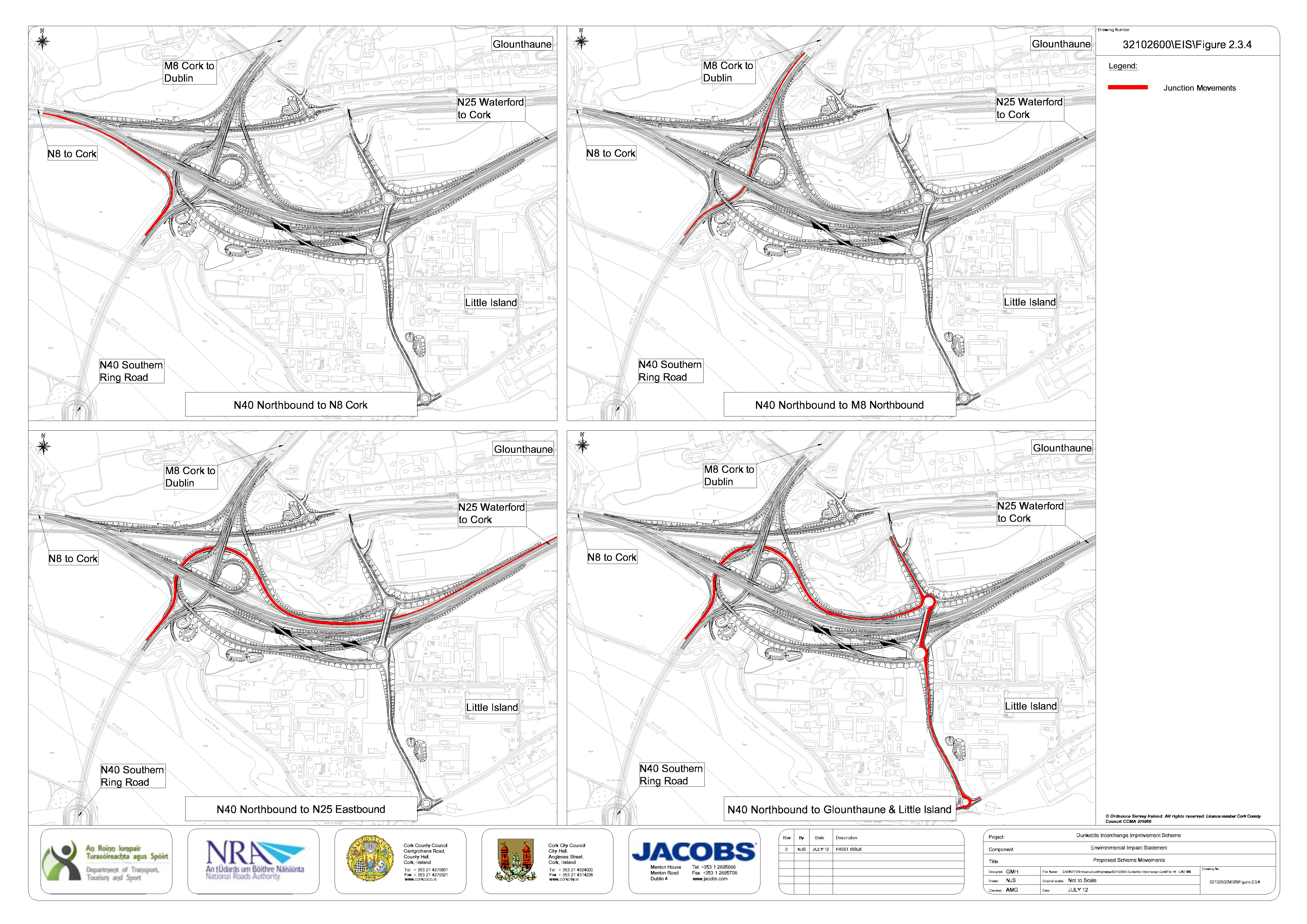
It's for another slip road. You can see in the diagrams above.
Its placement doesn’t match any drawing or diagram though. The additional slip road merges with the mainline much later, after the bridge crosses the rail line, with the slip not going near where that pillar per the webcam shots.
Of course, those diagrams may be inaccurate / plans have changed.
I also am baffled by that pillar. Visible at 38 seconds in this YouTube video: https://youtu.be/RvGvkMl0iIM
Pillar to mount a gantry or cantilever?
So, after a bit of head-scratching and comparing maps, here’s what has happened: The pink drawing is the existing interchange and approaches; the background is the finished plan. The M8 carriageway that has been demolished is dashed in black, and the new link for northbound M8 is in yellow.
The next change for this movement would be to build the bridge to take M8 northbound from tunnel (marked A on my diagram), at which point Northbound traffic will be diverted onto that. Don’t know if that could be done before late Summer, though, but things can happen surprisingly fast on these projects.
That could only be a temporary movement though as link A will evtually only carry N25 East to M8 North traffic.
The final Tunnel to M8 north traffic will go over the current bridge which at the moment is temporarily being accessed with the yellow line you’ve drawn. Traffic exiting the tunnel will eventually go north by veering to the right and eventually onto the new bridge. The top right picture shows this final movement.
i would be very surprised if Tunnel to M8 North traffic will ever use link A even in a temporary alignment. Link A is for one movement as per top right below.
Okay. I had forgotten the exact movements, but anyway it’s clear that this link cannot stay in place. I can’t see when that final West-to-North movement would go live, but it could be quite late in the project.
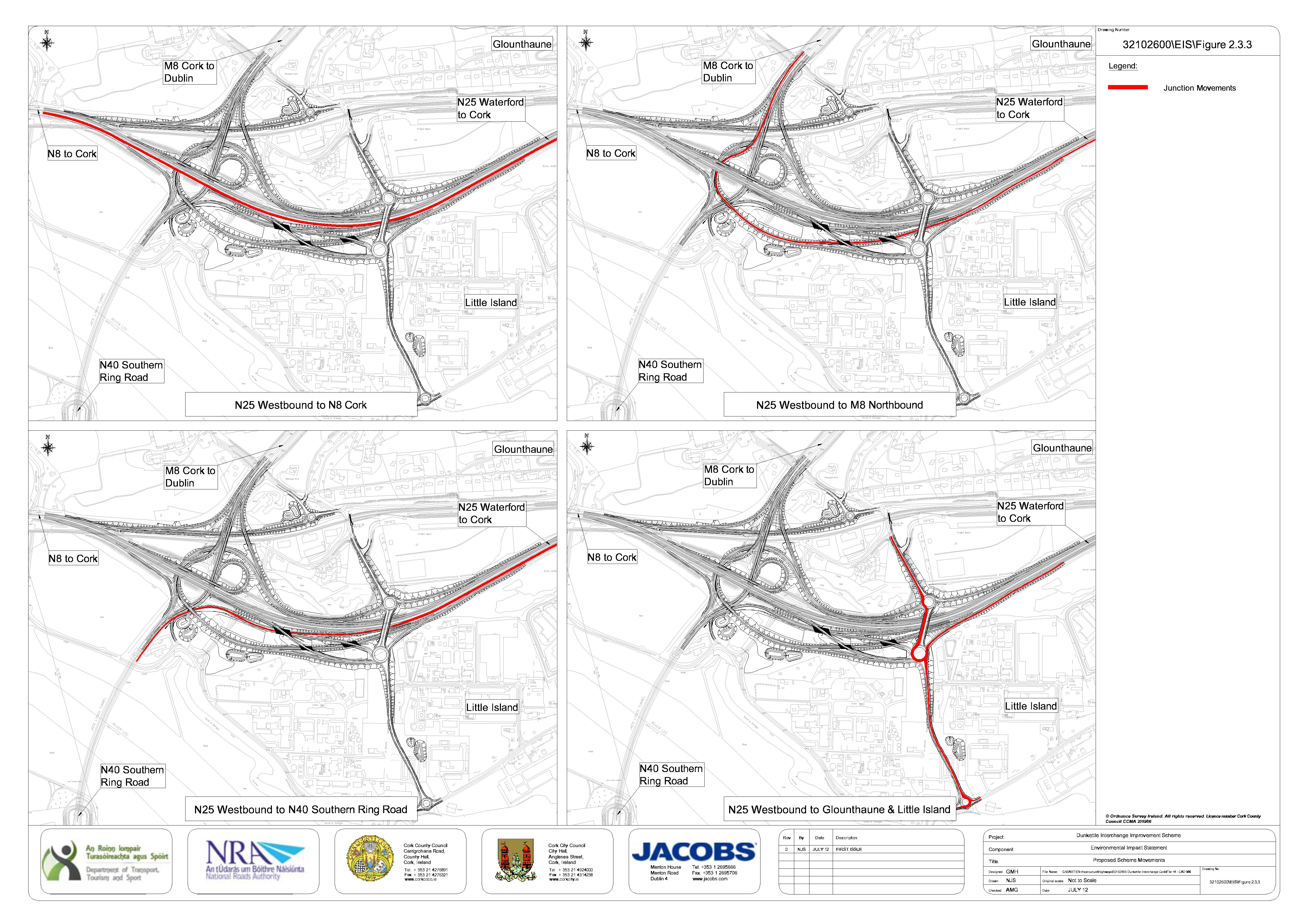
What is also clearer when comparing the two maps is that the current Westbound N25-N8 carriageway is going to be removed, with Westbound traffic for the city being eventually routed over the current eastbound deck, and the new deck being constructed North of that will eventually carry Eastbound N25 vehicles - basically the East-West road is being shunted North by three lanes.
The reason the old Westbound N25 has to go to give the N25-M8North loop space to safely change height: it leaves the main East-to-West road at the same elevation, must stay under the Little Island junction structures, then vault over the main North-South carriageways, before turning and going under the East-West carriageways. Trying to do that with the East-West carriageways as far south as they are now would be lethal for traffic
That will be tight for headspace going over M8 north and then under N25 west. Interesting
Suspect the mainline coming out of the tunnel will be lowered to help in this case.
All very interesting. Thanks all!
That'll be an absolute riot to build!
Current view from about half ways on. The concrete tunnel from the old road over the railway is now clearly visible.
Huge work done to demolish the old road already.
Dont think thats correct. The road you've marked "A" will be the slip for traffic coming from the east and heading north on the M8. Traffic coming from the tunnel heading north on the M8 will go over the new bridge where the traffic currently goes north on the M8. In order to do that traffic will travel from the tunnel under the eastern over bridge of the existing roundabout.
A couple of shiny new bridge beams were being put up in the rain this morning - just next to the new junction south of the N25.
I think they are the final beams in order to take the Little Island access road over the myriad of slip roads underneath?
Work seems to be focusing on opening the M8 East to M8 north slip.
Some change in one week. You wouldn’t think there was an active motorway going over that railway bridge less than a week ago.
N8E -> M8N is next as you say. End of March 2022 according to the email
They’ve really dug away where the old road was, where the new slip road for Tunnel to M25 East will go.
I think they’ll let the old rail concrete tunnel remain and utilise it for the N25 West to M8 North movement.
Took the screenshot below from the Dunkettle cam north yesterday. You can see given the perspective of the "small" white van how much they've dug out already. The way this is going the Tunnel to East Cork slip that is to run under the new bridge could be completed very quickly indeed.
Re the old bridge that used to take the M8 north and south over the railway bridge, I wonder will it actually be removed? In order to provide for the new east cork to M8 north link they will still have to construct another two or three structures to bridge over the railway line, the new tunnel to east cork link as well as the new slip road feeding in to that new roundabout to the east of the primary school. I'd imagine it may well just be cleaner to remove that railway bridge in its entirety? I could be wrong on that. We'll find out soon I suppose!
 :):)
:):)