pad199207 wrote: » Odd shapes and sizes
NotToScale wrote: » Is it still matching the track that’s been predicted by the models? Just wondering how it’s comparing to the last runs?
Mental Mickey wrote: » What does this mean
Mortelaro wrote: » If its barely capable of 100kmh gusts at sea,then it's a dying storm already
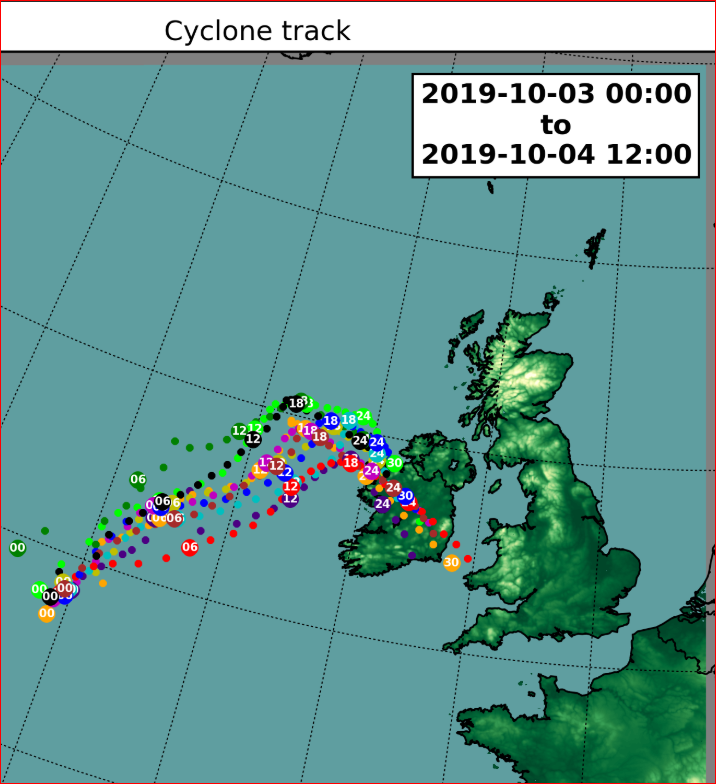
Storm Lorenzo was located around 180 nautical miles (340 km) west of Belmullet, Co Mayo at Midday today Thursday 3rd October 2019. The analysed pressure at 9z (1000 local) today was 969hPa at the M6 Buoy which is located approximately 400 km west of Mace Head in Galway as the centre of the storm passed over, with storm force west to southwest gusts recorded on the southern side of the low pressure centre.Our model guidance is calling for some slight deepening of the Lorenzo low to take place this afternoon as the system tracks north-eastwards to the west of Ireland, reaching a low of possibly 962hPa at 14z (1500 local). Because of this, south-easterly winds will be strong and gusty over much of the country this afternoon, with a countrywide yellow wind warning in operation until 6pm today. The storm depression is forecasted to then turn east south-eastwards this evening towards the west coast of County Mayo (around 18z/1900local). This turn is due to upper air steering flows high up in the atmosphere. By this time, the depression will be starting to fill. What this means is that the storm force winds on the southern side of the low will begin to slowly subside. At 6pm, the orange level wind warning for western coastal counties of Galway, Mayo, Clare, Kerry and Limerick will come into operation, and the yellow wind warning will become confined to Cork, Waterford, Tipperary and Wexford. Lorenzo is expected to make landfall between Erris Head and Killala Bay in County Mayo around midnight or soon after. Strong winds and large waves will affect western and southern coasts this evening and tonight with the potential for coastal flooding and damage. Lorenzo is expected to fill quite rapidly as it tracks south-eastwards over the country overnight. Winds in the centre and to the north of the low will be generally light to moderate variable. There will, however, be pulses of heavier rain in the centre and to the north of the low, with a yellow rainfall warning in operation to account for this. Below is some recent track guidance for the centre of Lorenzo from our HARMONIE Irish Regional Ensemble Prediction suite from midnight 3rd Oct to midday on 4th October.
Graces7 wrote: » Villain wrote: » The Met Eireann commentary has been updated https://www.met.ie/forecasts/meteorologists-commentary. That image is... scary! My home is under that! I have tried to attach a Sat 24 screenshot of Lorenzo from 2pm. It would appear to be following along the most northerly of the tracks progged by the met models
Villain wrote: » The Met Eireann commentary has been updated https://www.met.ie/forecasts/meteorologists-commentary. That image is... scary! My home is under that!
KingdomRushed wrote: » I have tried to attach a Sat 24 screenshot of Lorenzo from 2pm. It would appear to be following along the most northerly of the tracks progged by the met models
Kamili wrote: » I was wondering this, been tracking it on ventusky and it seems to be a little off the predicted course, thought I was going crazy as I am not very adept at these things.
Blackhorse Slim wrote: » That has to be a mistake on the Met Eireann national wind warning? Should be valid until 06:00 Friday, same as the other warnings, not 18:00 Thursday (today)
squarecircles wrote: » conditions in West Mayo half hour ago.