munsterlegend wrote: » The french will be disappointed.
Gaoth Laidir wrote: There will be no hurricane eye over Ireland. There will be the centre of the depression, which we always get. The country is totally overreacting to this.
The One Doctor wrote: » How does an eye make any difference? The tropical storm still has a massive amount of energy and is currently reintensifying due to the warm waters around Spain. We're had destructive storms before with no eye to them. What people need to understand is the destructive potential of fast moving air. Wind energy is proportional to the third power of the wind speed; if windspeed doubles, the destructive energy increases eight times. So 150kph winds are four times as destructive as 100kph winds. The risk of injury to people comes from 'entrained debris', basically things (deckchairs, wheelie bins, branches, broken glass) being caught by the wind and hurled at you. The danger relates to the energy of the wind. The more wind, the heavier the object it can hurl at you and your house.
Gaoth Laidir wrote: » Let's move on.
MuddyDog wrote: » Can there be twisters that make landfall because of this?
Overall synoptic conditions for a potential sting jet or major cold-conveyor belt (CCB) jet event seem to be in place, also supported by numerous fine-mesh models and even global models.
The most extreme winds should weaken during the end of the MD but intense CCB jet winds approach S-Ireland later-on from the S.
Oscarziggy wrote: » The BBC shipping forecast says this for Fastnet -- I've never heard the term in red used before . Regards Fastnet Gale Warning: Gale warning issued 15 October 09:55 UTC (Open) Southerly hurricane force 12 expected later Wind Cyclonic, mainly south or southwest, 5 to 7, increasing severe gale 9 to violent storm 11 later, occasionally hurricane force 12. Sea State Moderate or rough, becoming high or very high later, occasionally phenomenal. Weather Fair then rain. Visibility Good becoming poor.
DOCARCH wrote: » Moving quickly now alright....I retract my earlier theory of a possible miss!
crustybla wrote: » Around how fast is it moving at the moment?
Hurricane Ophelia Advisory Number 27 NWS National Hurricane Center Miami FL AL172017 500 PM AST Sun Oct 15 2017 ...OPHELIA STILL A HURRICANE BUT EXPECTED TO BECOME A POWERFUL POST-TROPICAL CYCLONE TONIGHT... SUMMARY OF 500 PM AST...2100 UTC...INFORMATION LOCATION...44.6N 13.3W ABOUT 840 MI...1355 KM NE OF THE AZORES ABOUT 505 MI...810 KM SSW OF MIZEN HEAD IRELAND MAXIMUM SUSTAINED WINDS...85 MPH...140 KM/H PRESENT MOVEMENT...NNE OR 25 DEGREES AT 38 MPH...61 KM/H MINIMUM CENTRAL PRESSURE...971 MB...28.68 INCHES WATCHES AND WARNINGS There are no coastal tropical cyclone watches or warnings in effect. Interests in Ireland should monitor products issued by Met Eireann, and interests in the United Kingdom should monitor products issued by the UK Met Office. DISCUSSION AND 48-HOUR OUTLOOK At 500 PM AST (2100 UTC), the center of Hurricane Ophelia was located near latitude 44.6 North, longitude 13.3 West. Ophelia is moving toward the north-northeast near 38 mph (61 km/h), and this general motion is expected to continue through Monday. On the forecast track, the center of Ophelia will cross over Ireland on Monday, however strong winds and rain will extend far from the center. Maximum sustained winds are near 85 mph (140 km/h) with higher gusts. Ophelia is expected to be a hurricane-force post-tropical cyclone when it nears the coast of Ireland on Monday. Hurricane-force winds extend outward up to 60 miles (95 km) from the center and tropical-storm-force winds extend outward up to 255 miles (405 km). The estimated minimum central pressure is 971 mb (28.68 inches). HAZARDS AFFECTING LAND WIND: Gale-force winds are expected to begin across southern Ireland by early Monday morning and gradually spread northward across the country during the day. Hurricane-force winds are expected to reach the southern portions of Ireland by Monday afternoon. Strong winds will then spread inland across the Ireland and parts of the UK into Monday night. Preparations to protect lives and property should be nearing completion. Wind speeds atop and on the windward sides of hills and mountains are often up to 30 percent stronger than the near-surface winds indicated in this advisory, and in some elevated locations could be even greater. RAINFALL: Ophelia is expected to produce rainfall amounts of 2 to 3 inches (50 mm to 75 mm) with isolated totals near 4 inches (100 mm) through Tuesday across western Ireland and Scotland. Across eastern Ireland, rainfall amounts will average around 1 inch (25 mm) or less. STORM SURGE: A dangerous storm surge is expected to produce significant coastal flooding near and to the east of where the center of the post-tropical cyclone makes landfall. Near the coast, the surge will be accompanied by large and destructive waves. NEXT ADVISORY Next complete advisory at 1100 PM AST. $$ Forecaster Zelinsky
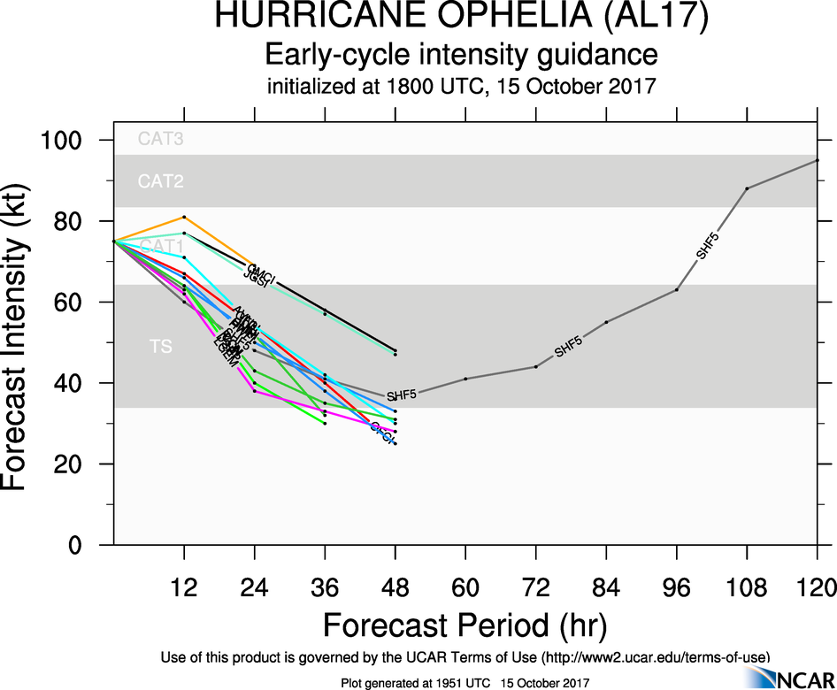
Hurricane Ophelia Discussion Number 27 NWS National Hurricane Center Miami FL AL172017 500 PM AST Sun Oct 15 2017 Ophelia's cloud structure is declining rapidly, and microwave and shortwave IR imagery indicate that the low-level and mid-level centers are becoming separated. However, some deep convection is still present near Ophelia's center, and an SSMIS pass from 1827 UTC indicated that the hurricane still has an inner core that is separated from a front to the north and west. The estimated maximum winds have been decreased slightly to 75 kt given the overall decay of the cloud structure. However, the cyclone's favorable position relative to an upper-level jet streak is likely contributing to deepening of the low as the wind field expands substantially. Only a slight decrease in the maximum winds is therefore expected before the post-tropical cyclone reaches Ireland. After that time, interaction with land while the cyclone occludes should cause it to weaken more rapidly. Around 48 h, the cyclone's circulation is likely to become ill-defined and dissipate near the western coast of Scandinavia. Ophelia has continued to move toward the north-northeast, and the initial motion estimate remains 025/33 kt. There has been no change to the track forecast reasoning since Ophelia is already embedded within the flow associated with a large mid-latitude trough. This should keep Ophelia on a north-northeast heading as it passes over Ireland and the UK on Monday. The dynamical guidance remains in very good agreement on the track of Ophelia, and very little change has been made to the track forecast. Since Ophelia will be post-tropical as it approaches Ireland and the UK, strong winds and rain will arrive over land areas sooner than the center. For more information on local impacts, consult products from local meteorological services in Ireland and the United Kingdom for more information. KEY MESSAGES: 1. Ophelia is expected to be a powerful extratropical cyclone with hurricane force winds while it moves near Ireland and the United Kingdom. Direct impacts from wind and heavy rain in portions of these areas are likely, along with dangerous marine conditions. For more details on the magnitude, timing, and location of impacts from post-tropical Ophelia, residents in Ireland should refer to products issued by Met Eireann, and residents in the United Kingdom should refer to products issued by the Met Office. 2. Individuals are urged to not focus on the exact track of Ophelia since strong winds and heavy rainfall will extend well outside of the NHC forecast cone. FORECAST POSITIONS AND MAX WINDS INIT 15/2100Z 44.6N 13.3W 75 KT 85 MPH 12H 16/0600Z 49.2N 11.3W 70 KT 80 MPH...POST-TROP/EXTRATROP 24H 16/1800Z 54.3N 7.5W 55 KT 65 MPH...POST-TROP/EXTRATROP 36H 17/0600Z 58.5N 2.0W 40 KT 45 MPH...POST-TROP/EXTRATROP 48H 17/1800Z...DISSIPATED $$ Forecaster Zelinsky
star gazer wrote: » Advisory 27
[Deleted User] wrote: » 5pm (EDT, 10pm Ire) NHC graphics chart.
Akrasia wrote: This looks like Ophelia might still be a hurricane at landfall (or very close)
M.T. Cranium wrote: » Not the first time we've had to post this, but times on NHC guidance maps are set to eastern North American time zones (AST is same as EDT) and those are 5 hours behind IST, so add five hours to your time estimates. Just saw some discussions about arrival around 0600 but really that's 1100h IST.
MJohnston wrote: » Estofex is indicating "isolated tornado risk" and has been for a while:http://www.estofex.org/
gozunda wrote: » The storms latest depiction on nullschool shows a very distinct eye / centre despite other reports if the eye having begun breaking down ...https://earth.nullschool.net/#current/wind/surface/level/orthographic=-14.05,52.24,1362


![Photo of [Deleted User]](https://w2.vanillicon.com/v2/23cbe5e5e50cebb31e4a86160a77c62d.svg)


![Photo of [Deleted User]](https://wf.vanillicon.com/v2/f4416408dd0710a1385793d2e72d08f2.svg)