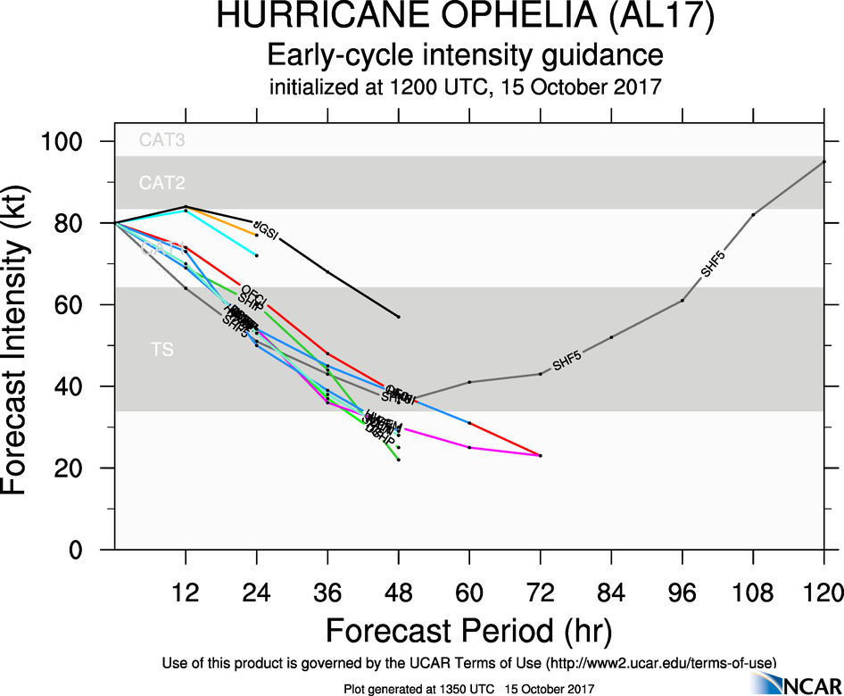
Gaoth Laidir wrote: » Looks like the NHC have downgraded it to 80 knots now as the 12Z SHIPS forecast below has it initiated at that intensity. It forecasts it to be fully extratropical by 18Z this evening and at around 54 knots intensity by 12Z tomorrow as the centre moves inland over SW Kerry at around 27 knots. In the case of land interaction the LGEM forecast is likely to be more accurate.
M.T. Cranium wrote: » Having reviewed a visible satellite loop I would say the storm is still tropical and the eye has reduced in diameter to about 5 miles (current position 40N 16W). It appears to be making the turn north in the last three hours. The waters ahead are not all that cold either, near 20 C in Biscay. And the strong southerly flow will bring a slight warming further north. This storm may continue to be a hybrid like Sandy up until landfall. Storm surge issues should be taken very seriously on this track (from SSW). You know the terrain better than me, but any coastal villages with exposure to the south or southwest may have inundations up to 3 metres above normal high tide and powerful waves could be bringing in debris from beaches.
TheMilkyPirate wrote: » 160-180km/h gusts in Wexford and Waterford if that icon materialised. I really don't think people understand the severity of this.
munsterlegend wrote: » I think you had a site for predicting wind strength in a location? Could you post it again thanks?
Reggie. wrote: » What is that string of calm wind?
TheMilkyPirate wrote: » Sure,https://weather.us/forecast/2960964-wexford/ensemble/euro/wind-gusts
Gaoth Laidir wrote: » Side-by-side comparison of Arpege and Hirlam mean winds tomorrow at 13Z. The bottom right of each image shows the max winds on that chart, so the Arpege shows 66 knots out to sea south of Cork while the Hirlam has 61 knots. A few knots less along the coast in each case.
M.T. Cranium wrote: » goat2 ... your question needs a more precise location but I think the strongest winds at most locations between Bantry Bay and Roches Point will be SSW to SW, from Bantry Bay around to Valentia more of a mix of directions depending on exact track of the centre. question about highest storm surge, technically that is the time when water level is displaced highest vs expected from tide tables, but public will perceive it to be at high tide, and in any case it appears that these are similar, IIRC somebody posted them in the 3-4 p.m. range along the south coast. Storm surge is likely to peak whenever the centre of the low is to your west and that appears to be 2-3 p.m. for most locations along the south coast. It's only about two days to new moon by late Monday, astronomical tides must be fairly close to peak I would imagine within a foot?
M.T. Cranium wrote: » I always think Iberia looks like a human face looking west, and today there's quite a sight. this.
Drumpot wrote: » Does the storm surge apply to middle/northern east coast ? I am in bettystown and my estate has flooded before in conditions that weren't as bad as this . High tide (due at 10pm tomorrow) followed by prolongued rain caused the problem. I am wondering if my estate needs to be on alert and if we should contact the council!
Donegal Storm wrote: » Nothing on the met website yet but Meteoalarm suggesting that they've issued an orange rainfall warning now as well with 40mm+ possible, Joanna Donnelly said on the farming forecast that they'd be issuing one this afternoon
STATUS ORANGE Rainfall Warning for Connacht, Wexford, Donegal, Clare, Cork, Kerry, Limerick and Waterford Heavy rain at times on Monday with some local flooding, especially in coastal areas. 40+ mm possible. Issued: Sunday 15 October 2017 14:00 Valid: Monday 16 October 2017 09:00 to Monday 16 October 2017 21:00STATUS YELLOW Rainfall Warning for Dublin, Carlow, Kildare, Kilkenny, Laois, Longford, Louth, Wicklow, Offaly, Westmeath, Meath, Cavan, Monaghan and Tipperary Heavy rain at times on Monday with some local flooding, especially in coastal areas. 25 to 40 mm possible. Issued: Sunday 15 October 2017 14:00 Valid: Monday 16 October 2017 09:00 to Monday 16 October 2017 21:00