mirrorwall14 wrote: » I know it’s for Monday? I also know that models roll out overnight and I’m wondering what times so I can check them since I’ll likely be awake anyways. I knew all the times way back in the big freeze but I’ve forgotten
star gazer wrote: » 50 Knot:
adox wrote: » Weather on RTE finished with the line " we have got something to look forward to on Monday" :eek:
mirrorwall14 wrote: » sword1 wrote: » It's for Monday, hopefully it will be downgraded tomorrow I know it’s for Monday? I also know that models roll out overnight and I’m wondering what times so I can check them since I’ll likely be awake anyways. I knew all the times way back in the big freeze but I’ve forgotten
sword1 wrote: » It's for Monday, hopefully it will be downgraded tomorrow
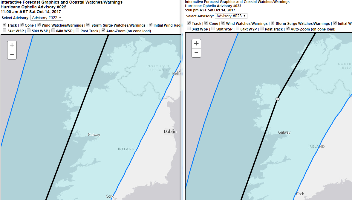
INIT 14/1500Z 34.8N 26.6W 100 KT 115 MPH 12H 15/0000Z 36.5N 23.0W 95 KT 110 MPH 24H 15/1200Z 40.5N 18.0W 90 KT 105 MPH 36H 16/0000Z 46.5N 14.0W 85 KT 100 MPH...POST-TROP/EXTRATROP 48H 16/1200Z 51.5N 11.0W 75 KT 85 MPH...POST-TROP/EXTRATROP 72H 17/1200Z 59.0N 6.0W 40 KT 45 MPH...POST-TROP/EXTRATROP 96H 18/1200Z...DISSIPATED
INIT 14/2100Z 35.9N 23.7W 100 KT 115 MPH 12H 15/0600Z 38.0N 20.0W 95 KT 110 MPH 24H 15/1800Z 42.8N 15.3W 85 KT 100 MPH 36H 16/0600Z 48.8N 12.3W 75 KT 85 MPH...POST-TROP/EXTRATROP 48H 16/1800Z 54.0N 9.3W 60 KT 70 MPH...POST-TROP/EXTRATROP 72H 17/1800Z 59.5N 3.5W 40 KT 45 MPH...POST-TROP/EXTRATROP 96H 18/1800Z...DISSIPATED
spookwoman wrote: » Updated NOAA
nagdefy wrote: » Quite a shift to the east?? Are any other posters going googley eyed with charts?:) I mean that in a good way. Thanks to everyone for the wonderful contributions. Re. rte weather forecasts. It's very difficult to hit the right note. You don't want to cause panic, but you are trying to be professional and serious. Joanna was fine. Her comment about looking forward to Monday was typically her! But she got the serious parts in with the comparisons to Darwin and Debbie. And as we all know by now it's a fluid situation and may end up a bit of a now cast.
nagdefy wrote: » Quite a shift to the east??
sdanseo wrote: » Centreline on NHC @ 21Z vs 15Z looks about 10km further east. Very marginal. Add that to the fact that the storm is still a Cat 3, and expected to last longer, to my mind says upgrade. But as I've mentioned before in the thread MT, Gaoth etc would be hundreds of times more knowledgeable about the mechanics of it where I'm only really comparing charts as opposed to analysing them.
MJohnston wrote: » Not quite - you need to understand what those wind probability charts represent. Close to the current position of the hurricane, they literally represent how likely those areas are to receive particular strengths of winds. However, the further you get along the predicted track of the storm (ie. further into the future), the probabilities change not just because areas are less likely to get hit by particular strength winds, but also because the likelihood of the forecast being correct is less certain.
Gaoth Laidir wrote: » Looking forward to readings from Sherkin Island and Roches Point. Also, could have anomalously high Föhn readings from Valentia. Later on, Mace Head and Belmullet will be interesting.
emeldc wrote: » The charts in #1385 and #1388 seem to be the same only compleatly different as regards the position of the worst winds. Maybe I'm just reading it wrong
CloughCasey1 wrote: » Agree with that. She usually knows her stuff. She usually comes across no more than the usual suspects on here as a total weather nerd. She looked like she was bursting to tell everyone what may/might/probably will happen and would only love to be showing the general public of the ifs and buts of what is LIKELY to happen. She looked nervous.....and rightly so....as she knows the severity of the upcoming situation and she also knows that she has to act 100% professional on the national airways.
NASlad wrote: » Odds on this being a complete flop and not half as bad as we're expecting? Can't say I'm too worried yet. Will make up my mind Sunday night.
sdanseo wrote: » Latest NHC update. Of specific note comparison between predictions 6 hrs ago and now: 1500UTC 2100UTC Essentially, they expect it to become extratropical around the same time, and still hit 53N at around 65kt - Category 1 force - but keep going for longer afterwards before dissipating. Note the size of the cone is much narrower, so much less uncertain. This doesn't seem to be any further west, even though it might look that way, because the cone only shows the position of the centre and not the size of the storm, as they explain.
spookwoman wrote: » Looking at the forecast on https://www.ventusky.com/?p=51.0;-5.9;5&l=wind using the ICON and GFS models they both seem to show the south east and east getting hit
Gaoth Laidir wrote: » But the anemometer there is I think over 100 metres above the sea so really not of any use.
MJohnston wrote: » You are (sorry!) - pay attention to the force of the winds that is listed in the title of the charts, one is showing the probabilities for 34+ knots winds, and the other for 50+ knot winds. You can check out all 3 wind speed probabilities charts (the third is for 64+ knot winds) here:http://www.nhc.noaa.gov/refresh/graphics_at2+shtml/205031.shtml?tswind120#contents