channaigh wrote: » How will Kilkenny fair in this Robert ?
luimneachboy wrote: » For those that have a good knowledge, at the moment what's this looking like for West limerick /north kerry
RobertKK wrote: » I wouldn't be surprised if like with Storm Darwin, we ended up with a red warning. We only got the red warning upgrade during that storm when we were in the middle of the worst conditions and trees were falling down everywhere, power cuts happening and conditions that were just too dangerous to be out in. Be prepared for the worst, and hope for the best.
mel.b wrote: » Just wondering what has caused this hurricane to travel east towards us, rather than west as they typically do? Is it due to where it first formed?
Weathercheck wrote: » At present the Greater Dublin area looks least exposed so may lessen slightly the coverage of the storm.
Cloudio9 wrote: » The chart in post 894 shows a scenario where the east gets hit as hard as the west and this is going to peak around the evening rush hour.
Kai Rotten Shipwreck wrote: » Interesting question.. hope someone can answer it!
Hurricane Ophelia is an odd storm. It’s a picture-perfect hurricane with winds around 90 MPH, but that’s not the odd part, of course. What makes this storm weird is its location. It’s way out in the Atlantic, where it’s usually too cool for hurricanes to develop—much less survive. Ophelia is so far off the beaten path that instead of heading for the Americas (as so many storms have this season), the system will evolve and threaten Ireland and the United Kingdom early next week.
Met Éireann—Ireland's meteorological service—is advising residents to keep a close eye on the storm as it approaches the Isles, emphasizing the uncertainty in the forecast. A statement by the agency on Thursday noted that "it won’t be possible to quantify the exact timing, nor the strength or intensity of the wind and rain, in any great detail until later in the weekend." Weather alerts issued by the U.K.'s Met Office read much the same, noting the potential for damaging winds, heavy rain, and scattered power outages in Northern Ireland and along the western coast of Great Britain.
Nettle Soup wrote: » https://www.popsci.com/hurricane-ophelia-british-isles#page-3
Stephen Hawkins football boots wrote: » The weather is so warm at the moment, excuse the cliche but is this calm before storm?Is the hurricane the reason it's so warm?
mel.b wrote: » That talks about how/why Ophelia has survived but not what caused her to come east in the first place which is what I'm curious about.
Kermit.de.frog wrote: » If this is not a CATEGORY 3 at the next advisory i'll eat my hat.
Working class heroes wrote: » What time for the next advisory?
leahyl wrote: » Red warning on ME site now, someone has prob already said this...so ignore me if that’s the case haha
Meteorite58 wrote: » Wow !
enricoh wrote: » Will there be good surfing to be had Monday?! Dont want to take a day off monday n trek west for nothing!
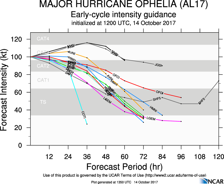
Hurricane Ophelia Discussion Number 22 NWS National Hurricane Center Miami FL AL172017 1100 AM AST Sat Oct 14 2017 During the past few hours, Ophelia's satellite presentation has improved significantly. The eye has become even more distinct with a temperature of 16 deg C, and has been surrounded by very deep convection. T-numbers from TAFB and SAB have reached 5.5 on the Dvorak scale, and the objective numbers from CIMMS have been oscillating around T5.8 and T5.9 recently. Based on these estimates, the initial intensity has been increased conservatively to 100 kt, making Ophelia a category 3 hurricane on the SSHS. Ophelia is a quite intense and rare hurricane for its location in the northeastern Atlantic. Increasing shear and cold waters will soon begin to impact Ophelia, and the hurricane should begin to acquire extratropical characteristics in about 36 hours or sooner. Although some weakening is anticipated, Ophelia is expected to reach the British Isles as a powerful extratropical cyclone with hurricane force winds. Dissipation is forecast in about 4 days after the system moved over these Isles. Satellite fixes indicate that Ophelia is moving toward the northeast or 055 degrees at 22 kt. The hurricane is well embedded within the southwesterly flow associated with the southern extension of a large mid-latitude trough, and this pattern should continue to steer the cyclone northeastward and north-northeastward with increasing forward speed for the next 2 to 3 days until dissipation. Track models are in excellent agreement and the guidance envelope is quite tight. The NHC forecast is not different from previous ones, and it is very close to the HFIP corrected consensus HCCA and the multi-model ensemble TVCX. Given that Ophelia is forecast to become extratropical, the wind field should expand, resulting in impacts over portions of the British Isles regardless of its exact location or strength. Although the center of Ophelia is not forecast to reach Ireland or the UK for another couple of days, wind and rains will arrive well in advance of the cyclone center. Individuals in those locations should consult products from their local meteorological service for more information on local impacts. Tropical-storm-force winds are possible throughout the Azores after Ophelia passes to the south and east later today and tonight as a cold front moves through the islands. Interests in the Azores should refer to products issued by the Azores Weather Forecast and Watch Center. KEY MESSAGES: 1. Ophelia is expected to be a powerful extratropical cyclone with hurricane force winds Monday while it moves near Ireland and the United Kingdom. Direct impacts from wind and heavy rain in portions of these areas are likely, along with dangerous marine conditions. For more details on the magnitude, timing, and location of impacts from post-tropical Ophelia, residents in Ireland should refer to products issued by Met Eireann, and residents in the United Kingdom should refer to products issued by the Met Office. FORECAST POSITIONS AND MAX WINDS INIT 14/1500Z 34.8N 26.6W 100 KT 115 MPH 12H 15/0000Z 36.5N 23.0W 95 KT 110 MPH 24H 15/1200Z 40.5N 18.0W 90 KT 105 MPH 36H 16/0000Z 46.5N 14.0W 85 KT 100 MPH...POST-TROP/EXTRATROP 48H 16/1200Z 51.5N 11.0W 75 KT 85 MPH...POST-TROP/EXTRATROP 72H 17/1200Z 59.0N 6.0W 40 KT 45 MPH...POST-TROP/EXTRATROP 96H 18/1200Z...DISSIPATED $$ Forecaster Avila
LaVail wrote: » Do we have any sort of idea as to roughly when this storm would hit? Monday morning AM or more towards Monday night?