leahyl wrote: » A serious downgrade? Really? Who’s saying this?
Akrasia wrote: » There are a lot of people who want to be the 'i told you so' guy, so they wander into a discussion, make a predictive statement pretending that they know it will happen, and only return to gloat if it turned out to be right. It's like someone going all in in poker with a pair of 2s. If they lose they say they were bluffing, if they get a lucky draw and win with a full house, they claim foresight and skill
fraxinus1 wrote: » Haastentoad and Gaooith laidir saying it's not going to be asent bad as what people think and one of then mentions max gust of 85mph which is strong but we get that somewhere in Ireland every year.
George Sunsnow wrote: » Darren Brett there on BBC News 24 just now saying gusts of 80 MILES per hour possible in eastern Northern Ireland If that’s what pans out up there,there’s only one word for further south :eek:
jvan wrote: » Yeah, not much talk about the East coast but some of the models look like having very strong winds along Irish sea coastal counties.
Strawberry Milkshake wrote: » Penneys have gold/metal frame lights that are battery operated and these cheap one metre LED strips. The light off them is much better than a candle. If you're shopping today, I'd recommend buying some. Don't forget to buy AA + AAA batteries! Once again, thanks all for the posts. I'm in the better to be safe than sorry camp.
Meteorite58 wrote: » Looks incredible seeing a hurricane so far North, well defined symmetrical eye.
guanciale wrote: » Hi folks and thank you for all of the info and advice. Informative and not hysterical. I live in SW Kerry and have begun preparations. I would not be preparing at all only for this site. I think Met Eireann, the Govt and insurance companies could do a lot more to inform people. You have filled that void. What is the advice for people with very large windows. US sites say do not tape up ut instead fit storm shutters. Is it the case here that we simply have to suck it up, hope for best and prep for worse. Or is there anything practical that can e done. I have begun removing external potential missles.
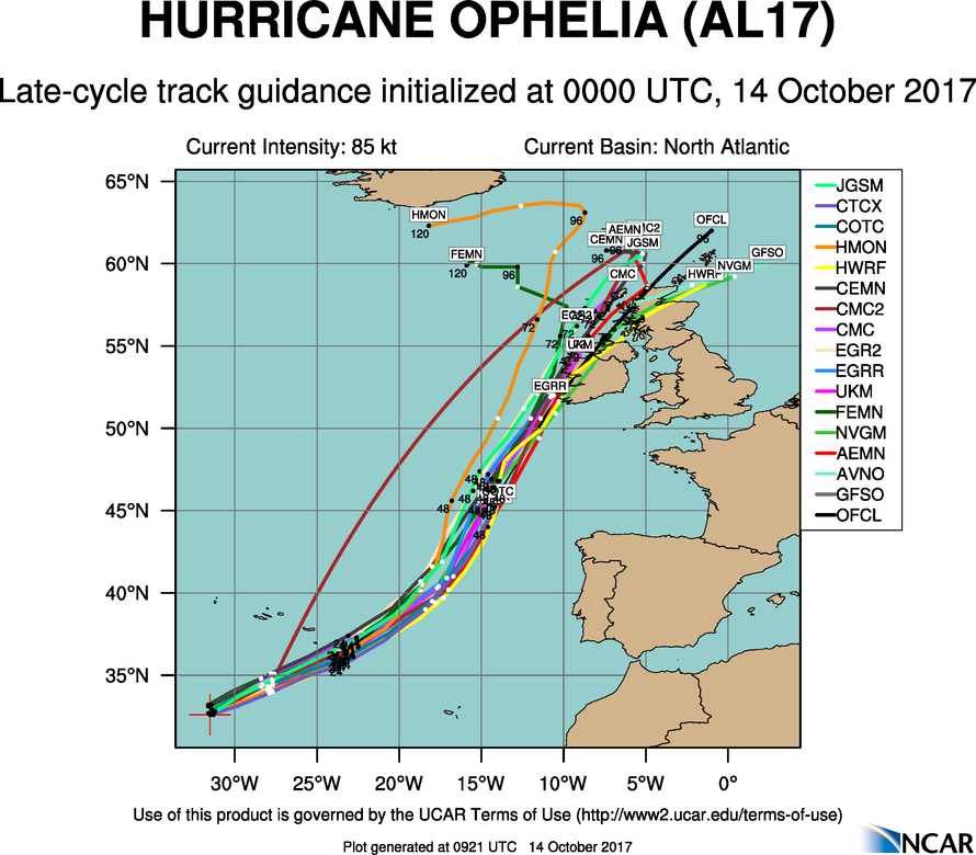
Hurricane Ophelia Discussion Number 21 NWS National Hurricane Center Miami FL AL172017 500 AM AST Sat Oct 14 2017 Ophelia's 20-nmi-diameter eye has continued to become more distinct and cloud-free, with the eye temperature now reaching 15 deg C. Satellite intensity estimates range from T4.5/77 kt from TAFB to T5.0/90 kt from SAB and T5.5/102 kt from UW-CIMSS ADT. For now, the initial intensity will remain at 85 kt, which is an average of the available intensity estimates. The initial motion estimate is 060/21 kt. Ophelia is embedded within deep-layer southwesterly flow on the east side of a broad mid-latitude trough. The global and regional models remain in excellent agreement on the trough amplifying over the next 3-4 days, which will cause the hurricane to accelerate toward the northeast at forward speeds near 30 kt by 48 hours. The tight clustering of the NHC model guidance, which shows very little cross-track or along-track spread, increases the confidence in the official track. As a result, no significant changes were made to the previous advisory, and the new forecast track remains near the middle of the guidance envelope, close to the HCCA and TVCX consensus models. Ophelia is expected to remain in relatively low vertical wind shear environment for the next 12 hours or so, which should help the hurricane retain much of its current intensity during that time, even though SSTs are only going to be 24-25C. However, upper-level temperatures that are still about 2 deg C cooler than normal, which will help to create sufficient instability to continue to drive the development of inner-core convection. By 36 hours or so, the shear is forecast to increase to 30-40 kt and the troposphere is expected to become stable as sea-surface temperatures decrease to less than 20 deg C. However, even those SST values are about 2 deg C warmer than normal for this time of the year. Those above-average ocean temperatures are forecast to combine with strong baroclinic energy associated with a potent, negatively tilted, upper-level trough, causing Ophelia to transition into a powerful extratropical low pressure system. By 48 hours, the post-tropical cyclone is forecast to maintain sustained hurricane-force winds as it approaches Ireland, with stronger winds expected over higher terrain. Given that Ophelia is forecast to become extratropical, the wind field should expand, resulting in impacts over portions of the British Isles regardless of its exact location or strength. By 96 hours, Ophelia should have weakened due to the interaction with land, causing the surface circulation to become ill-defined, and dissipation is expected shortly thereafter. Although the center of Ophelia is not forecast to reach Ireland or the UK for another 48-60 hours, wind and rain effects will arrive well in advance of the cyclone center. Individuals in those locations should consult products from their local meteorological service for more information on local impacts. Tropical-storm-force winds are possible throughout the Azores beginning tonight, primarily due to an approaching cold front. However, any track deviation to the west could bring stronger winds associated with Ophelia's circulation to those islands. Interests in the Azores should refer to products issued by the Azores Weather Forecast and Watch Center. KEY MESSAGES: 1. Ophelia is expected to become a hurricane-force post-tropical cyclone by Monday before it moves near Ireland and the United Kingdom. Direct impacts from wind and heavy rain in portions of these areas are likely, along with dangerous marine conditions. For more details on the magnitude, timing, and location of impacts from post-tropical Ophelia, residents in Ireland should refer to products issued by Met Eireann, and residents in the United Kingdom should refer to products issued by the Met Office. FORECAST POSITIONS AND MAX WINDS INIT 14/0900Z 33.9N 28.6W 85 KT 100 MPH 12H 14/1800Z 35.3N 25.4W 80 KT 90 MPH 24H 15/0600Z 38.3N 20.4W 80 KT 90 MPH 36H 15/1800Z 43.0N 16.0W 75 KT 85 MPH...POST-TROP/EXTRATROP 48H 16/0600Z 48.4N 12.5W 75 KT 85 MPH...POST-TROP/EXTRATROP 72H 17/0600Z 57.4N 6.3W 50 KT 60 MPH...POST-TROP/EXTRATROP 96H 18/0600Z 63.1N .5W 40 KT 45 MPH...POST-TROP/EXTRATROP 120H 19/0600Z...DISSIPATED $$ Forecaster Stewart
Gaoth Laidir wrote: » The guys we see in the US boarding up windows and using storm shutters are doing so in preparation for proper hurricanes of Cat 2,3,4, etc. We may not get even Cat 1. I think people are getting a bit carried away with this system. It will be windy, but the damage potential of what we may get is several times lower than say a Cat 3.





![Photo of [Deleted User]](https://wb.vanillicon.com/v2/b9d7cf56a75eee6d7dd35aa28294f673.svg)