JanuarySnowstor wrote: » My thoughts before the 12zs come out is that there's a clear nudge West by the gfs since this time yesterday. I'm very surprised the Met didn't wait until this evening to do a warning. If the ecm moves more towards gfs then let's be clear there is no storm! We'll know a good bit more by tonight but the trend this morning is West and away from our shores
fraxinus1 wrote: » That's good to hear. I was going to ask a neighbour to have a look at the shed roof but no need to. I hope Met Eilean feel silly now with their hype about high impact weather. Meet a neighbour earlier and it was all talk about a big storm. I told him the word is it will stay out to sea to the west.
...OPHELIA MEANDERING SOUTHWEST OF THE AZORES... ...EXPECTED TO BEGIN MOVING NORTHEASTWARD LATER TODAY... SUMMARY OF 1100 AM AST...1500 UTC...INFORMATION LOCATION...30.5N 35.6W ABOUT 715 MI...1145 KM SW OF THE AZORES MAXIMUM SUSTAINED WINDS...90 MPH...150 KM/H PRESENT MOVEMENT...NNE OR 20 DEGREES AT 2 MPH...4 KM/H MINIMUM CENTRAL PRESSURE...978 MB...28.88 INCHES
Iancar29 wrote: » Seriously???????
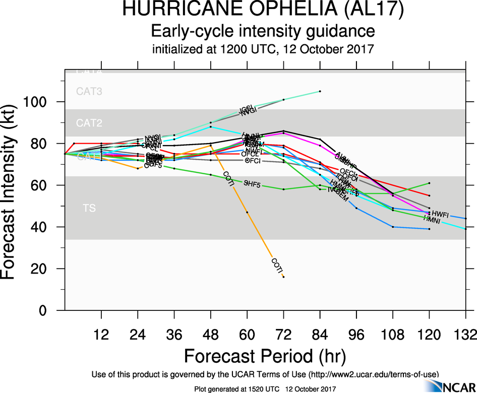
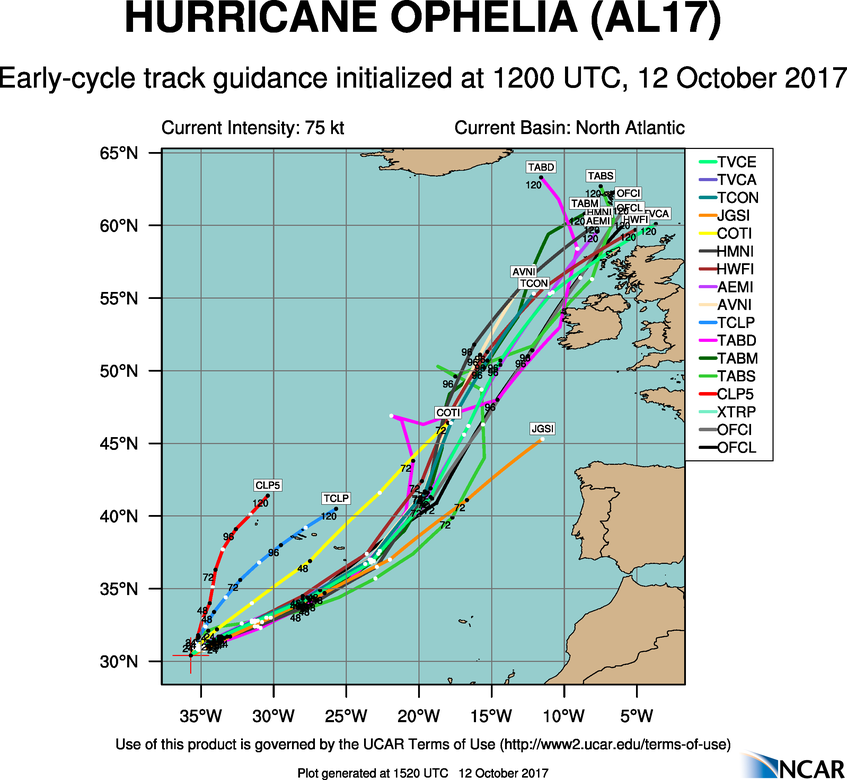
Hurricane Ophelia Discussion Number 14 NWS National Hurricane Center Miami FL AL172017 1100 AM AST Thu Oct 12 2017 Ophelia's satellite presentation consists of a distinct eye in infrared imagery surrounded by a ring of cloud tops of -50C to -70C. The initial intensity of 80 kt is based on a blend of the latest subjective and objective Dvorak estimates, which range from 77 to 95 kt. Little change in intensity is expected during the next 48 hours, as Ophelia will remain over SSTs of 25-26C and in a low to moderate shear environment. After that time, the cyclone should begin extratropical transition as it interacts with a potent mid-latitude trough moving eastward across the north Atlantic. This baroclinic interaction should maintain Ophelia at hurricane intensity through 96 hours, with slow weakening expected after that time as the extratropical cyclone occludes. Ophelia has moved little since the last advisory, with the cyclone currently situated south of the mid-latitude westerlies. The initial motion estimate is a slow north-northeastward drift at around 2 kt. A steadier northeastward motion should begin by 12 h when the aforementioned upper-level trough begins to exert influence on Ophelia's motion. An east-northeastward acceleration is expected at 24 through 48 h, followed by a turn back to the northeast and north-northeast at days 3 through 5 as Ophelia interacts with the southern portion of the trough. Through the first 48 hours, the new NHC track forecast is similar to the previous one and lies near the middle of the guidance envelope. Later in the forecast period, there remains a fair bit of east/west spread in the track of Ophelia near Ireland and the United Kingdom, which isn't usual at these time ranges. The NHC forecast at these times is similar to the previous one and lies on the right side of the deterministic guidance envelope but is near the middle of the ECMWF, UKMET and GEFS ensemble members. Regardless of the exact track, post-tropical Ophelia is likely to bring some impacts to Ireland and the United Kingdom as a powerful extratropical cyclone in 4 to 5 days. While the track guidance keeps the center of Ophelia east of the Azores, a tropical storm watch or warning could be needed for the eastern Azores later today or tonight because of the expected increase in the size of the tropical-storm-force winds in the northwestern quadrant of the cyclone. KEY MESSAGES: 1. Ophelia is expected to transition to a hurricane-force post-tropical cyclone by Monday when it moves near Ireland and the United Kingdom. While post-tropical Ophelia will likely bring some direct impacts from wind and heavy rain to portions of these areas, as well as dangerous marine conditions, given the forecast uncertainty at these time ranges it is too soon to determine the exact magnitude, timing and location of the impacts. Residents in Ireland and the United Kingdom should monitor the progress of Ophelia for the next several days. For more information on local impacts, residents of Ireland should refer to products issued by Met Eireann and residents in the United Kingdom should refer to products issued by the Met Office. FORECAST POSITIONS AND MAX WINDS INIT 12/1500Z 30.5N 35.6W 80 KT 90 MPH 12H 13/0000Z 30.9N 34.9W 80 KT 90 MPH 24H 13/1200Z 31.6N 33.4W 80 KT 90 MPH 36H 14/0000Z 32.7N 30.8W 75 KT 85 MPH 48H 14/1200Z 34.4N 27.3W 75 KT 85 MPH 72H 15/1200Z 40.9N 18.8W 75 KT 85 MPH 96H 16/1200Z 51.0N 12.5W 65 KT 75 MPH...POST-TROP/EXTRATROP 120H 17/1200Z 60.5N 5.5W 55 KT 65 MPH...POST-TROP/EXTRATROP
fraxinus1 wrote: » You know perfectly well that's a typo you pompous git
FutureGuy wrote: » As someone who only ever uses the forum to see if his parents house is going to be ok, can someone break it down please. If the worst possible scenario plays out and the storm hits us, would it be worse than Desmond in 2014?
coillsaille wrote: » What part of the country is the house in?
FutureGuy wrote: » Near Charleville on the Cork/Limerick border. Sorry, that would have been useful information.
JCX BXC wrote: » That's quite far inland, is there any reason in particular that the house would be more at risk that other dwellings in the area?
FutureGuy wrote: » Our land survived everything for 30 years, but Desmond broke 5 large trees. Hence my need to gauge it. My dad is elderly so will need help to make sure things are well in place before the weekend.