Advertisement
If you have a new account but are having problems posting or verifying your account, please email us on hello@boards.ie for help. Thanks :)
Hello all! Please ensure that you are posting a new thread or question in the appropriate forum. The Feedback forum is overwhelmed with questions that are having to be moved elsewhere. If you need help to verify your account contact hello@boards.ie
Hi all! We have been experiencing an issue on site where threads have been missing the latest postings. The platform host Vanilla are working on this issue. A workaround that has been used by some is to navigate back from 1 to 10+ pages to re-sync the thread and this will then show the latest posts. Thanks, Mike.
Hi there,
There is an issue with role permissions that is being worked on at the moment.
If you are having trouble with access or permissions on regional forums please post here to get access: https://www.boards.ie/discussion/2058365403/you-do-not-have-permission-for-that#latest

Dish pics request - Elfordstown, RTÉ & Mt Gabriel

  • 20-01-2007 6:29pm
    #1
    Registered Users, Registered Users 2 Posts: 1,733 ✭✭✭


    Just looking for more pics of the above earth stations.

    One of Elfordstown on web archive:
    363556995_f8163169d2_o.jpg
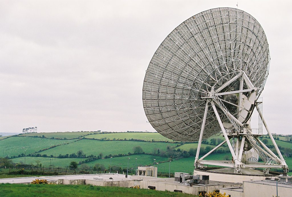
    Elfordstown, Ireland's largest earth station, entered service in 1984 and carries telecommunications traffic to Europe and North America. There are 3 antennae in the Earth station complex. The largest, a 32 meter Intelsat Standard A, carries the North American, Canadian and Saudi Arabian traffic. European destinations use the 11 meter antenna in Eutelsat TDMA system. The third antenna, a 13.5 meter Intelsat Standard B, is used for PTAT cable restoration.
    http://web.archive.org/web/20010428084828/indigo.ie/~eftirl/

    There was a link to the RTÉ uplink dishes mentioned here when they first went onto Astra. But the link therein is dead, and also broken on wayback. Anyone got these saved to hard drive?


    Finally there's a mention of Mt Gabriel, Schull on the Wiki entry on Echelon
    Any more info on this?


«1

Comments

  • Registered Users, Registered Users 2 Posts: 32,417 ✭✭✭✭watty


    Mt Gabriel is Irish Aviation. Atlantic Approach Radio. I knew a guy that worked there. (died recently). The IRA bombed it once thinking it was NATO. It is only civil radar. Nothing to do with Echelon.


    Elfordstown Google Earth
    http://www.tageo.com/kml.php?lat=51.951&long=-8.164&place=Elfordstown


  • Registered Users, Registered Users 2 Posts: 1,733 ✭✭✭Zaphod


    Thanks watty. I hadn't heard of Mt Gabriel before and only came across it while looking for info on Elfordstown.

    I also recall a 6-8M dish right in the middle of Tralee town, near the courthouse but it was dismantled a few years back. Anyone know what became of it?

    On a similar note from the Armstrong website
    1995 Satellite Earth Station installed for RTE in Tralee, Co. Kerry.

    Again anyone know of this?


  • Closed Accounts Posts: 7,230 ✭✭✭Solair


    It's amazing that old Telecom Eireann webpage is still online. The wonders of archiving! I would suspect however, that the Midleton dish no-longer plays a major role in Irish telecommunications. Almost all international calls and data go by fiber optic routes thesedays and Ireland's has pretty substantial connections to various fiber networks. The only role that dish would have thesedays is to serve as a back up, should there be a problem with fiber.

    Satellite links are generally prone to echos and delays so, for live phone traffic they're not great.

    It'd be interesting to know what traffic actually goes through it thesedays though.

    Any ideas?


  • Registered Users, Registered Users 2 Posts: 32,417 ✭✭✭✭watty


    Yes Middleton is mothballed. eircom are open to the right offer...


  • Registered Users, Registered Users 2 Posts: 6,638 ✭✭✭zilog_jones


    There's some dish about the same size as the smaller ones in that picture in Castletroy (Limerick) behind the old AIB. Any idea what it could be? Could it be something to do with UL? Looks pretty old and mossy anyway - I'll take pics some time if I remember to bring a camera to college.


  • Advertisement
  • Registered Users, Registered Users 2 Posts: 1,733 ✭✭✭Zaphod


    AFAIK the one in Limerick near the Jewish graveyard is owned by TE/Eircom.


  • Registered Users, Registered Users 2 Posts: 78,490 ✭✭✭✭Victor


    Background information on Mount Gabriel including some specificiations http://vekinis.org.lu/mtgabri.html

    I was on the mountain c. 1977 (please remember I was 5 at the time). The INLA blew up at least one in 1982, but I understand there are two again. They have built a fence. :) In 1977 it had two radomes that looked like this. http://www.flickr.com/photos/eoinoc/265122067/

    It would be possible that they are the same http://historical-debates.oireachtas.ie/S/0102/S.0102.198312140006.html

    Some pics all pointing in the wrong directions. :(

    Interesting links
    http://www.eurocontrol.int/asterix/gallery/content/public/documents/archives/part1/astx1v1e.pdf
    http://www.sei.ie/index.asp?locID=325&docID=-1
    http://www.sei.ie/getfile.asp?FC_ID=925&docID=260
    http://www.raytheon.com/businesses/stellent/groups/ncs/documents/content/cms04_019499.pdf

    List of aircraft radars http://www.aaiu.ie/upload/general/3500-0.PDF (MSSR = Monopulse Secondary Surveillance Radar)


    Dooncarton, Mayo http://images.google.ie/images?svnum=10&hl=en&q=Dooncarton+&btnG=Search


    UCC used to have an array of 3-5m dishes on their tall building (science?).


  • Registered Users, Registered Users 2 Posts: 6,638 ✭✭✭zilog_jones


    The one on Woodcock Hill (on that Flick link above) is quite visible on Google Earth:
    52°43'15.52"N
    8°42'26.54"W

    I think there may have been an older one there that was dismantled - I vaguely recall there being two up there for a while - or maybe I am imagining things.


  • Registered Users, Registered Users 2 Posts: 1,733 ✭✭✭Zaphod


    443528340_ae4ac8dde3.jpg

    443528330_4bfba16e2e.jpg

    Looks like a Viasat setup similar to the one in Donnybrook.


  • Registered Users, Registered Users 2 Posts: 32,417 ✭✭✭✭watty


    The one on Woodcock Hill (on that Flick link above) is quite visible on Google Earth:
    52°43'15.52"N
    8°42'26.54"W

    I think there may have been an older one there that was dismantled - I vaguely recall there being two up there for a while - or maybe I am imagining things.

    Yes there were two. The base may still be there.


  • Advertisement
  • Registered Users, Registered Users 2 Posts: 2,330 ✭✭✭Antenna


    Some photos of Mt Gabriel on the web.
    gabriel1.jpg
    gabriel2.jpg
    gabriel5.jpg

    one of the 2 Radomes has an RTE TV relay around its wall. 2 sets of UHF panels facing different areas (one set is H polarisation, the other Vertical), the receive aerials for Mullaghanish also visible


  • Closed Accounts Posts: 89 ✭✭Scottish paddy


    Has anyone got a pic of the Sky uplink dish at Donnybrook?


  • Registered Users, Registered Users 2 Posts: 1,321 ✭✭✭Foggy43


    Antenna!
    Looking at the close up pictures of Mount Gabriel can you tell me what the white rectangular panels are? There are in a group of 4.

    I have seen them at ground level and presumed they were either low power mobile phone base stations or handheld radio related?

    Just Curious!


  • Registered Users, Registered Users 2 Posts: 69,543 ✭✭✭✭L1011


    Foggy - I'd suspect they're the RTE relay he mentioned just below the pics.


  • Registered Users, Registered Users 2 Posts: 1,321 ✭✭✭Foggy43


    MYOB!
    Just after hitting 'submit reply' I had this flash back to a picture of a deflector site on the Comeragh Mountains. A UHF Yagi Antenna and one of those 'panels'.

    I am sure it was somewhere in this website but it is unavailable at the moment.
    http://www.geocities.com/corkradio/tvch.html

    Not exactly the above but a link from it. http://www.geocities.com/corkradio/txgal5.html


  • Closed Accounts Posts: 89 ✭✭Scottish paddy


    Is the "Donnybrook Tower" still needed in these days of satellite links and fibre optic? Surely this anachronism can now be dismantled?


  • Registered Users, Registered Users 2 Posts: 78,490 ✭✭✭✭Victor


    Back-up to the back-up? Although I suspect it is actually the primary.

    And mobile phones?


  • Registered Users, Registered Users 2 Posts: 2,330 ✭✭✭Antenna


    Zaphod wrote:
    I also recall a 6-8M dish right in the middle of Tralee town, near the courthouse but it was dismantled a few years back. Anyone know what became of it?

    I remember reading there was a passive deflector in the Slieve Mish Mountains to reflect microwave signals between Tralee and Limerick (for telephone network). I suspect this is what the dish was for (was it aimed at the mountains?).

    the microwave reflector is mentioned here:
    http://mountainviews.ie/mv/index.php?mtnindex=339 (COMMENTS for Barnanageehy )


    BTW folks the Mt Gabriel pics above are on free web hosting. If there is too much usage, they will be unavailable for periods of time (just try later if they dont appear).


  • Closed Accounts Posts: 61 ✭✭tea


    I took some photos at Elfordstown a few years ago. If memory serves correctly, the photos below is of the main dish there (I seem to recall there were three in total). I have a few more at ,
    http://www.cybercom.net/~mark/Ireland/Elfordstown 2004/ and I have a couple more offline - if it would be helpful I'll dig them out.CNV00009.jpg


  • Registered Users, Registered Users 2 Posts: 32,417 ✭✭✭✭watty


    It's not in use.

    They should make it available for Radio Astronomy for Transition year students to encourage science.


  • Advertisement
  • Registered Users, Registered Users 2 Posts: 903 ✭✭✭MiketheMechanic


    You're correct Antenna, this passive deflector on Slieve Mish was blown down during high winds some years ago. I don't believe it was still in use at that time. The Stack's mounatins were in the way of direct communications between Tralee and Limerick, hence the need in the first instance.

    Does anyone know where the transmitter/receiver at the Limerick end was based?

    73's
    MtM
    Antenna wrote:
    I remember reading there was a passive deflector in the Slieve Mish Mountains to reflect microwave signals between Tralee and Limerick (for telephone network). I suspect this is what the dish was for (was it aimed at the mountains?).

    the microwave reflector is mentioned here:
    http://mountainviews.ie/mv/index.php?mtnindex=339 (COMMENTS for Barnanageehy )


  • Closed Accounts Posts: 1,242 ✭✭✭Ulsterman 1690


    RE: The Donnybrook mast would they not need planning permission to demolish it ??

    And with the possibility that it might be needed for something in the future or that there may be mobile phone companies and suchlike wanting to rent space on it It would be madness to demolish it unless its getting in the way.

    Of course it has been suggested that RTE flog off the entire Donnybrook complex to property developers and move operations to someplace land is cheaper (next door to TG4 perhaps :D )


  • Registered Users, Registered Users 2 Posts: 1,733 ✭✭✭Zaphod


    Antenna wrote:
    I remember reading there was a passive deflector in the Slieve Mish Mountains to reflect microwave signals between Tralee and Limerick (for telephone network). I suspect this is what the dish was for (was it aimed at the mountains?).

    My shakey memory was that its was directed towards the sky, rather than the mountains, although it was on a Telecom Éireann site.
    watty wrote:
    They should make it available for Radio Astronomy for Transition year students to encourage science.

    Funnily enough, the Radio Telescope for Ireland project specifies a 32M dish, just like the Elfordstown one. Whether it would have a sufficient elevation/azimuth range or not is another story.
    http://www.arti.ie/tech_specs.php

    BTW there was a program this evening on RTÉ about Collins Steeplejacks with some archival footage of the installation of the radome at Mt Gabriel and the subsequent formation of Collins Essco in the manufacture/installation of radomes.
    http://www.l-3com.com/essco/about/plantlocations.html


  • Registered Users, Registered Users 2 Posts: 78,490 ✭✭✭✭Victor


    RE: The Donnybrook mast would they not need planning permission to demolish it ??
    AFAIK, to demolish something does not need planning permisison unless it is either (a) residential or (b) listed.
    Of course it has been suggested that RTE flog off the entire Donnybrook complex to property developers and move operations to someplace land is cheaper (next door to TG4 perhaps :D )
    Can you imagine the taxi bill then? :D


  • Closed Accounts Posts: 1,242 ✭✭✭Ulsterman 1690


    Victor wrote:
    AFAIK, to demolish something does not need planning permisison

    Admitidely im not an expert but was under the impression that any large (i.e. bigger than a garden shed) structure needed planning permission for demolition if its been there more than a certain number of years unless it could be shown to be in a dangerous condition
    unless it is .....residential

    Well surely its only "residential" if someone lives there and one generally tends to avoid demolishing structures with people inside (although there are exceptions :eek: )


  • Closed Accounts Posts: 89 ✭✭Scottish paddy


    I would hardly think it needs planning permission to dismantle it, as it doesn’t exactly add to the scenic beauty of Donnybrook!:rolleyes:


  • Registered Users, Registered Users 2 Posts: 1,733 ✭✭✭Zaphod


    Zaphod wrote:
    BTW there was a program this evening on RTÉ about Collins Steeplejacks with some archival footage of the installation of the radome at Mt Gabriel

    Not Mt Gabriel but Woodcock Hill:


  • Registered Users, Registered Users 2 Posts: 1,733 ✭✭✭Zaphod


    Anyone in the vicinity of Kilmainham might keep an eye out for this:

    1181301968494.jpg


    Webb telescope should be able to observe edge of universe

    Dick Ahlstrom, Science Editor

    A full-scale model of a space telescope which, when in orbit, should be able to see the edge of the universe, has touched down in Dublin.

    The 80ft (24.38m) model came to earth at the Royal Hospital, Kilmainham, where it will remain on public display for two months.

    The real James Webb space telescope (JWST) will not be launched until 2013, but when it does go into orbit it will carry a little bit of Ireland. Scientists from the Dublin Institute for Advanced Studies are part of a 10-country European consortium building Miri, one of the experiments to be carried on the telescope.

    "We are immensely proud to be involved in this exciting new project," the institute's Prof Tom Ray said yesterday. The model was brought over from the Smithsonian Institution in Washington to mark a meeting of participants in the telescope project at the Royal Hospital this week. The initiative is funded jointly by the US National Aeronautics and Space Administration (Nasa) and the European and Canadian space agencies.

    The meeting will involve 300 international scientists and space technology companies, who will discuss progress on the telescope.

    Dr John Mather, JWST chief project scientist and 2006 Nobel Prize winner, was also at the Royal Hospital. He will deliver two public lectures during the week, including one at Trinity College this evening organised by The Irish Times, the Royal Irish Academy and Depfa Bank. He will also give a public lecture on Thursday June 14th, organised by the institute which also plays host for this week's meeting at the Royal Hospital.

    Prof Ray was instrumental in bringing the JWST review meeting to Dublin. "It is important for Ireland because it emphasises that there is Irish involvement in a major international project," he said. "It shows our expertise is equal to the best of them."

    The giant 80ft by 40ft by 40ft model is impressive. However, the real space instrument will be an engineering marvel when built and launched.

    The Webb telescope will be many times more sensitive than the soon to be retired Hubble space telescope, which orbits several hundred miles overhead and will be located a million miles into space.

    This is necessary because the highly-sensitive instruments will have to be kept at a temperature of minus 270 degrees in order to operate properly.

    One of the telescope's key roles will be in discovering new planets and improving our understanding of how stars form, Prof Ray said.

    Newly formed planets tend to be very hot and Miri (Mid-Infrared Instrument) will be able to see the heat given off by new planets and infant stars.
    © 2007 The Irish Times


  • Registered Users, Registered Users 2 Posts: 837 ✭✭✭BarryM


    Antenna wrote:
    Some photos of Mt Gabriel on the web.
    gabriel1.jpg
    gabriel2.jpg
    gabriel5.jpg

    one of the 2 Radomes has an RTE TV relay around its wall. 2 sets of UHF panels facing different areas (one set is H polarisation, the other Vertical), the receive aerials for Mullaghanish also visible

    The whole set-up on Gabriel has been expanded quite a lot recently. I can see it out the window, from here on Sherkin Island.

    It was originally an IAA installation (and still is theirs) which has a link back to the Shannon IAA station. The two dishes point out to a point about 15W where Irish/Eurocontrol airspace begins. Shannon handles all traffic from 15W; south to about 45N and north to about 56N. The whole area is called Shanwick, part of it was controlled from Prestwick.

    Recently (last 5 years or so) RTE installed a UHF tv transmitter there; various mobile operators have installed relays and a number of local broadband suppliers have relays there too, for wireless BB. This message routes through one of them!!

    The irony, to my mind, is that IAA presumbaly paid eircom or one of its predecessors, for the fibre optic link to Shannon and now eircom sublets bits of it to RTE, mobile operators and wireless BB suppliers......

    Bye, Barry


  • Advertisement
  • Registered Users, Registered Users 2 Posts: 1,733 ✭✭✭Zaphod


    2825411399_a020a4062d_o.gif

    From here.


  • Closed Accounts Posts: 1,910 ✭✭✭barnicles


    Best viewed with netscape. Lol


  • Registered Users, Registered Users 2 Posts: 2,330 ✭✭✭Antenna


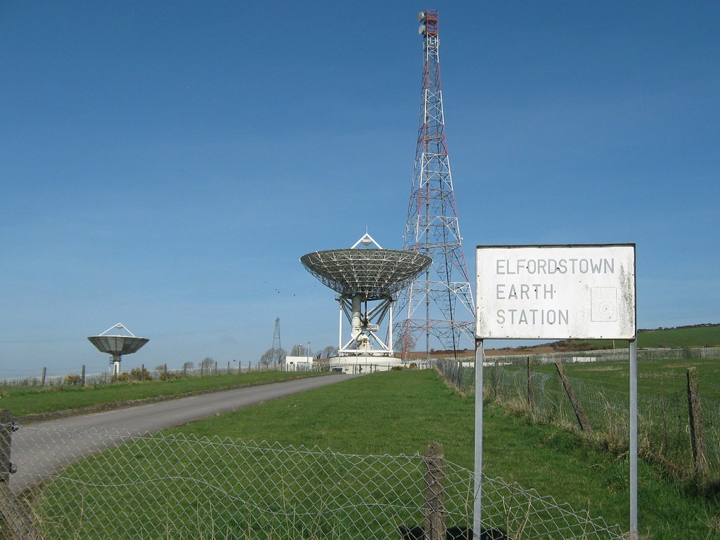
    Here are a few more recent pictures taken May 2008 of the Elfordstown earth station (which is roughly 2 miles north of the town of Midleton Co. Cork). Click on the pictures to expand.

    elfordstownbl4.th.jpg

    Entrance:
    elfordstownsignav3.th.jpg


    The largest dish (nowadays this and another one aimed straight upwards, I assume to decrease windloading whilst disused):
    elfordstownmaindishdi1.th.jpg


    Mast (high enough to see over hilly terrain to link with the Churchfield exchange high on the northside of Cork city). The mast is still used for mobile phone coverage (there would be none in much of the surrounding hilly terrain if it wasn't for this mast):
    elfordstowntopmastjo9.th.jpg

    weather station at corner of site to the left of entrance from the public road (looks fairly disused now):
    elfordstownweatheruk2.th.jpg


  • Registered Users, Registered Users 2 Posts: 1,733 ✭✭✭Zaphod


    Antenna wrote: »
    The largest dish (nowadays this and another one aimed straight upwards, I assume to decrease windloading whilst disused):
    elfordstownmaindishdi1.th.jpg

    What a waste. Even worse that it was taxpayer's money that paid for it and now it's being left to rot by those f*ckers in Eircom who have been screwing consumers wholesale since they were privatised. It should be taken off them and given over to the Radio Telescope crew.


  • Registered Users, Registered Users 2 Posts: 3,802 ✭✭✭Apogee


    3510456935_38267a1d86_o.jpg


    3511266266_0847ab0d76_o.jpg

    The concrete pads for the new mast were in place at the time of taking the photos. The mast is approx. 1/2 up by now.

    3510457131_d18d76aa8e_o.jpg

    3510457471_92c89350d4.jpg

    3510457381_c348d2a91f.jpg


  • Registered Users, Registered Users 2 Posts: 3,802 ✭✭✭Apogee


    3510458223_4fb3ba3c23_o.jpg

    3511267254_8c1fc5edb6_b.jpg

    3510458157_19a993ef81_o.jpg

    3510458603_1062660be4_o.jpg

    3511267630_1756ffc63c_o.jpg

    3510457235_f73f26acab_o.jpg

    3510457311_8594d98615_o.jpg

    3511267482_6f79dfd9d6_o.jpg


  • Advertisement
  • Registered Users, Registered Users 2 Posts: 8,147 ✭✭✭Ronan|Raven


    Some great pictures there, many thanks for uploading.


  • Registered Users, Registered Users 2 Posts: 2,171 ✭✭✭syboit


    Zaphod wrote: »
    What a waste. Even worse that it was taxpayer's money that paid for it and now it's being left to rot by those f*ckers in Eircom who have been screwing consumers wholesale since they were privatised. It should be taken off them and given over to the Radio Telescope crew.

    Is it gone now? Had a look at the google earth co-ordinates and nothing but a field.


  • Registered Users, Registered Users 2 Posts: 5,130 ✭✭✭John mac


    syboit wrote: »
    Is it gone now? Had a look at the google earth co-ordinates and nothing but a field.

    have a look here its still there !


  • Registered Users, Registered Users 2 Posts: 2,171 ✭✭✭syboit


    John mac wrote: »
    have a look here its still there !

    thanks, was able to find it on google earth now from that one. Here's a kmz file with location.


  • Registered Users, Registered Users 2 Posts: 12,577 ✭✭✭✭TheDriver


    Are the dishes in Mullaghanish as a backup if the usual pickup system fails?


  • Advertisement
  • Registered Users, Registered Users 2 Posts: 3,802 ✭✭✭Apogee


    These were taken in mid-March. The main dish is still in the "birdbath" position to withstand high winds - appropriately enough, given that the only thing making use of it are the crows for shelter.

    3476521220_4f6ca996d9_b.jpg

    3476591284_eb2200175e.jpg

    3475730355_5a63f63947_o.jpg

    3476533400_aefb2f6b5c.jpg

    3476525908_e3965f9a4d_b.jpg


  • Registered Users, Registered Users 2 Posts: 837 ✭✭✭BarryM


    Some great pictures there, many thanks for uploading.

    Tnks too, I'll be happy when they do the upgrade, I'm a 'client'

    BTW can anyone here explain why my '3' reception is crap when my RTE 1/2/4 is OK? I moved to a 'new' transmitter on Mount Gabriel which improved my RTE reception but crapped my 3....

    Tnks, Barry


  • Registered Users, Registered Users 2 Posts: 1,321 ✭✭✭Foggy43


    I maybe completley wrong but I wonder is TV3 available from Mount Gabriel.

    Perhaps we just ask for confirmation on the 'Terrestrial' forum?


  • Registered Users, Registered Users 2 Posts: 2,171 ✭✭✭syboit


    Apogee wrote: »
    These were taken in mid-March. The main dish is still in the "birdbath" position to withstand high winds - appropriately enough, given that the only thing making use of it are the crows for shelter.

    great pics, must take a spin down sometime for a look.


  • Registered Users, Registered Users 2 Posts: 1,321 ✭✭✭Foggy43


    BarryM wrote: »
    Tnks too, I'll be happy when they do the upgrade, I'm a 'client'

    BTW can anyone here explain why my '3' reception is crap when my RTE 1/2/4 is OK? I moved to a 'new' transmitter on Mount Gabriel which improved my RTE reception but crapped my 3....

    Tnks, Barry

    It appears that Mount Gabriel has the following.
    RTE1 Ch. 29
    RTE2 Ch. 33
    TV3 Ch. 26...But... has been allocated but not and probably will never be used.
    TG4 Ch. 23


  • Registered Users, Registered Users 2 Posts: 7,470 ✭✭✭highlydebased


    Was down by Elfordstown yesterday so stopped to have a look. A mind bogglingly unusual facility- no sign of life inside, there was an eircom van inside though. Main dish still pointed upwards, lots of rust all over the place

    t5fs9m33o5lo9ycsh4zg.jpg

    o6u5hfempaltqaoaf73g.jpg

    66a1jew0row1vpd7ua1c.jpg

    mdebnrfpy05c19h53rmm.jpg

    qi05kg5euorh9giznlwa.jpg


  • Registered Users, Registered Users 2 Posts: 3,802 ✭✭✭Apogee


    A busy site with many antennas and a road which has been cut to bits by rain.
    3695997332_bb88273787.jpg

    RTÉ transmitter:
    3695998146_0540f0ea9a_o.jpg

    Sky minidish backup (RTÉ A):
    3695191087_c8624b1466.jpg

    (RTÉ B):
    3696001334_e10b188de8.jpg

    (RTÉ C):
    3696001804_ea450b34e1.jpg

    (RTÉ D):
    3696002090_d544e4358e.jpg

    There is a second dish adjacent to the mast - based on its position relative to the minidish (top right) it's probably pointed at 27W for remote monitoring.
    3695998496_008dfce4f4.jpg


  • Registered Users, Registered Users 2 Posts: 3,802 ✭✭✭Apogee


    A wonky radio repeater with missing guidewires:
    3695997734_69e694c85f_o.jpg

    MMDS mast:
    3695999210_6d5d530e05_o.jpg

    MMDS mast B:
    3695188895_559242f5d5_o.jpg

    Microwave:
    3695999592_e2d53a5a95_o.jpg

    Internet?
    3696000086_470ecf9a19_o.jpg

    Prob wireless internet - permanet, kerrybroadband etc.
    3695190823_29547fe2c2_o.jpg

    Mobile:
    3695190463_ac800338db.jpg


  • Registered Users, Registered Users 2 Posts: 32,417 ✭✭✭✭watty


    3695998496_008dfce4f4.jpg
    That's at least a 4W TRANSMITTER on that dish. Maybe uplink.

    If two coaxes and one horn then it's an 2 way Internet link or 2way video (up & down) link.


  • Closed Accounts Posts: 216 ✭✭vsat


    Love to know how they alinged the dish correctly, since unistrut is clamped to the feed/focal point, as TX/RXing is very sentive in movement.:rolleyes:


  • Advertisement
Advertisement