Advertisement
If you have a new account but are having problems posting or verifying your account, please email us on hello@boards.ie for help. Thanks :)
Hello all! Please ensure that you are posting a new thread or question in the appropriate forum. The Feedback forum is overwhelmed with questions that are having to be moved elsewhere. If you need help to verify your account contact hello@boards.ie

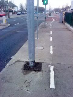
Pedestrians in the cycle lane

Options
123578

Comments

  • Closed Accounts Posts: 20,297 ✭✭✭✭Jawgap


    It's the 'new' lane by the airport (I think).

    Lovely and wide but it's shared and every lane & driveway that opens on to it is preceded by a yield - that's why I think it's better to stick to the road along there.


  • Moderators, Motoring & Transport Moderators Posts: 14,073 Mod ✭✭✭✭monument


    Jawgap wrote: »
    ... every lane & driveway that opens on to it is preceded by a yield...

    I've only seen one other pic of it and a glance of it from cars and buses while going into the airport, and it looked half ok.

    But Fingal could not leave out the yield markings or the crap bus stop placement as above.


  • Registered Users Posts: 87 ✭✭PrismES


    The new cycle lane from Churchtown to Dodder park road is very good, apart from the few local residents who believe its an overflow car park for their drive.
    Other than this particular cycle path, I stick to the roads.


  • Registered Users Posts: 8,619 ✭✭✭Tenzor07


    Jawgap wrote: »
    It's the 'new' lane by the airport (I think)

    That's the side just before Dardistown cemetery, the other side is just as good, smooth surface and no debris...
    Though when you get to the airport roundabout it vanishes completely and your back to using a standard pedestrian crossing if you are proceeding down to Swords...


  • Registered Users Posts: 2,454 ✭✭✭Icepick


    monument wrote: »
    Where exactly is that?

    Do you mind if I use your image for the weekly cycle lane feature on IrishCycle.com?
    Airport, direction Santry. It contains gps info.

    You can use it


  • Advertisement
  • Moderators, Category Moderators, Arts Moderators, Sports Moderators Posts: 48,649 CMod ✭✭✭✭magicbastarder


    monument wrote: »
    Do you mind if I use your image for the weekly cycle lane feature on IrishCycle.com?
    have you featured the cycle lane between the western end of the runway at the airport and kilshane cross?
    it's an offroad cycle lane, where the cyclist is obscured from the motorists (unless in a high cab) by a hedge, which then dumps the cyclist abruptly onto the road just at the point the road narrows.
    and does not seem to be built to link any two places together, either.


  • Registered Users Posts: 718 ✭✭✭gaffmaster


    Icepick wrote: »
    Public Service solution:

    2rwopoh.jpg

    FFS

    Looks like a drawing of a chap that has fallen off his bike, ironically.


  • Closed Accounts Posts: 6,925 ✭✭✭RainyDay


    I'm often tempted to try this approach


  • Closed Accounts Posts: 20,297 ✭✭✭✭Jawgap


    monument wrote: »
    I've only seen one other pic of it and a glance of it from cars and buses while going into the airport, and it looked half ok.

    But Fingal could not leave out the yield markings or the crap bus stop placement as above.

    Surface-wise it's good and being honest it doesn't carry that much pedestrian traffic so, imv, it's 'shareable.'

    The downside is the necessity to yield at just about every driveway and opening on to it. Second, the southbound element 'detours' into the roads leading to the long-stay carparks meaning if you stay on it you get dragged away from the main route and are forced to play 'sheep-pen slalom' to maintain progress.

    Likewise the northbound track doesn't suffer from the same problem with 'yields' but where it crosses the road into the airport it's a mess.

    In summary, I'd describe it as a well executed bad idea that confirms the primacy of motor vehicles in the thinking, planning and design activities of Fingal Co Co.

    The annoying thing is that with all the space there they could easily have done something much more usable.


  • Moderators, Motoring & Transport Moderators Posts: 14,073 Mod ✭✭✭✭monument


    Icepick wrote: »
    Airport, direction Santry. It contains gps info.

    You can use it

    Thanks.

    have you featured the cycle lane between the western end of the runway at the airport and kilshane cross?
    it's an offroad cycle lane, where the cyclist is obscured from the motorists (unless in a high cab) by a hedge, which then dumps the cyclist abruptly onto the road just at the point the road narrows.
    and does not seem to be built to link any two places together, either.

    No, not yet. A photo would be welcomed.


  • Advertisement
  • Moderators, Category Moderators, Arts Moderators, Sports Moderators Posts: 48,649 CMod ✭✭✭✭magicbastarder


    i'll try to get one next time i'm out that way.
    this might help illustrate - bear in mind that the hedge is higher than street view suggests, as the camera is mounted high on the car here; but from a car driver's point of view, a bike is going to appear from nowhere on the left:

    https://www.google.ie/maps/@53.4243851,-6.3158219,3a,75y,254.73h,78.09t/data=!3m4!1e1!3m2!1saA2XQDaBVgQu3uvZbY-XvQ!2e0


  • Registered Users Posts: 7,761 ✭✭✭Pinch Flat


    gaffmaster wrote: »
    Looks like a drawing of a chap that has fallen off his bike, ironically.

    It's the picture of the aftermath of hitting a pedestrian - bike on ground followed by felled pedestrian. Just need another symbol showing a cyclist holding their cracked rib cage or headache complete the picture.

    Anyway, pedestrians in cycle lanes are so yesterday - roller blading chaps and chapesses are all the rage in the Phoenix park cycle lanes these days.


  • Registered Users Posts: 9,147 ✭✭✭RobertFoster


    gaffmaster wrote: »
    Looks like a drawing of a chap that has fallen off his bike, ironically.
    Looks like a BMX/Motocross trick called Nothing to me :)
    i'll try to get one next time i'm out that way.
    this might help illustrate - bear in mind that the hedge is higher than street view suggests, as the camera is mounted high on the car here; but from a car driver's point of view, a bike is going to appear from nowhere on the left:

    https://www.google.ie/maps/@53.4243851,-6.3158219,3a,75y,254.73h,78.09t/data=!3m4!1e1!3m2!1saA2XQDaBVgQu3uvZbY-XvQ!2e0
    Getting on/off that track looks like a lot of fun too. It's overgrown a lot since Google drove by in 2009, I think the dished curb is more or less covered now.


  • Registered Users Posts: 9,318 ✭✭✭Macy0161


    monument wrote: »
    Where exactly is that?

    Do you mind if I use your image for the weekly cycle lane feature on IrishCycle.com?
    N11 between stillorgan park hotel and at least brewery road has the same, albeit more faded, markings and is a similar shared space. If you're looking for other examples! I think further out the n11 around cornelscourt might be the same, but I haven't cycled that stretch.


  • Registered Users Posts: 2,013 ✭✭✭nomdeboardie


    Macy0161 wrote: »
    N11 between stillorgan park hotel and at least brewery road has the same, albeit more faded, markings and is a similar shared space. If you're looking for other examples! I think further out the n11 around cornelscourt might be the same, but I haven't cycled that stretch.
    A short stretch south of the Cornelcourt junction southbound, between a bus stop and the petrol station suddenly sports a couple of these combos. (I realised this when I pointed at the bike logo indignantly while passing a couple of pedestrians...and then realised it had was followed by the walker logo :o:pac::mad::confused:)


  • Registered Users Posts: 8,619 ✭✭✭Tenzor07


    The Chinese now have "pedestrian lanes" for those who want to use mobile phones as they walk, great idea!! :D:D

    ddgihj.jpg

    2e5rrzt.jpg


    (and yes they are a great bunch of lads!!)


  • Registered Users Posts: 159 ✭✭Buchaill_Mor


    A short stretch south of the Cornelcourt junction southbound, between a bus stop and the petrol station suddenly sports a couple of these combos. (I realised this when I pointed at the bike logo indignantly while passing a couple of pedestrians...and then realised it had was followed by the walker logo :o:pac::mad::confused:)

    Are these appearing in the Fingal, DLR and South County Dublin areas, or are they migrating into the Dublin City Council areas also? Is this a new policy on road markings to be rolled out across the country?


  • Registered Users Posts: 2,013 ✭✭✭nomdeboardie


    Are these appearing in the Fingal, DLR and South County Dublin areas, or are they migrating into the Dublin City Council areas also? Is this a new policy on road markings to be rolled out across the country?
    I don't know. The N11 one has probably been there for quite a few years(?) I think they probably crop up sporadically. Then there's the 'implicit shared use' sections, such as for the re-re-engineered Killiney Towers roundabout :rolleyes:


  • Registered Users Posts: 9,318 ✭✭✭Macy0161


    Is this a new policy on road markings to be rolled out across the country?
    The bit around Stillorgan must be a good few years old - the road markings are fading off the tarmac at this stage!


  • Registered Users Posts: 2,245 ✭✭✭check_six


    Macy0161 wrote: »
    N11 between stillorgan park hotel and at least brewery road has the same, albeit more faded, markings and is a similar shared space. If you're looking for other examples! I think further out the n11 around cornelscourt might be the same, but I haven't cycled that stretch.

    Always amuses me that as long as there are two pictures painted on the ground there is no problem with cyclists and pedestrians sharing the same space. Everyone automatically smiles and laughs and there are pretty rainbows and lollipops for all.

    However, any cyclist rolling along on any other bit of footpath is assumed to be a bloodthirsty maniac, who is seconds away from crushing their next victim under their wheels of destruction.

    The general consensus is that they should be locked up and the key thrown away.

    Then a new key should be found, the cyclist taken outside, and then shot, and then hung, and wherever their corpse is dumped should be sown with salt. Perhaps their head may also be placed on a spike to warn off others.

    In summary, I don't see a problem with more shared paths, but I wouldn't recommend trying to hurry up on one.

    By the way, what is the status of South King Street in Dublin (near Stephen's Green)? Is it shared or not?


  • Advertisement
  • Registered Users Posts: 2,332 ✭✭✭tampopo


    monument wrote: »
    Where exactly is that?

    Do you mind if I use your image for the weekly cycle lane feature on IrishCycle.com?

    Hey,

    I sent you this one from Ballyfermot ages ago.

    DSC01979_zpsb9eb3202.jpg

    Did you ever use it?


  • Registered Users Posts: 19,617 ✭✭✭✭Muahahaha


    Jawgap wrote: »
    It's the 'new' lane by the airport (I think).

    Lovely and wide but it's shared and every lane & driveway that opens on to it is preceded by a yield - that's why I think it's better to stick to the road along there.

    I pass by that way twice, sometimes thrice a week on the bike. We were talking about it on page 3 of the Right of Way thread a few days back and a couple of other posters mentioned that they also cycle that route but don't use the cycle lane.
    http://www.boards.ie/vbulletin/showthread.php?t=2057284634&page=3

    As I said on that thread when I got back into cycling I used to use that cycle lane along the Old Airport Road but now I just use the road. The actual cycletrack itself isnt a bad job, very smooth surface. But this crap of getting to junctions and then having to cross like a pedestrian is just daf and for a commuting cyclist its just completely unpractical.

    On the issue of it being a shared track with pedestrians, I'm not completely against that given the path is so wide and even if pedestrians are two abreast you can still get past. Its not a perfect solution but the other solution of just painting a line down the middle doesnt work either, pedestrians take no heed of the line and I can't see that changing anytime soon. So I think in some instances where the space is available rather than cyclists being slowed down by pedestrians walking in a cycle lane lets instead put the onus on pedestrians and tell them its also a cycle lane and to use their common sense and expect bikes to be passing rhem. If they are afraid of that then they can stick to the left hand side and there'll still be a good 2 metres of space for bikes to pass them. All that said I don't think a sahred path was the right idea here, that road is plenty wide enough to have a cycle lane as well as a bus lane and two traffic lanes.
    Tenzor07 wrote: »
    That's the side just before Dardistown cemetery, the other side is just as good, smooth surface and no debris...
    Though when you get to the airport roundabout it vanishes completely and your back to using a standard pedestrian crossing if you are proceeding down to Swords...

    After you cross over the roundabout outside the airport if you continue north towards Swords there is a cycle lane mounted on the path. A lot of it has weeds growing into it from the hedge but its there. What makes it funny is I'm pretty sure there are some painted markings on it that show it is a two way cycle lane yet there is no marked space for pedestrians. When you arrive at the next roundabout the cycle lane spits you out onto the road. Funnily enough if any touring cyclists assemble their bikes in Dublin airport and set their Garmin cycle touring GPS to head north then it is likely that it would send them out of the airport and onto this cycle track, which lasts all of about 400m. Within less than two minutes of their cycling holiday they will be spit out of a cycle lane and into the junction of a busy roundabout with no cycle lane markings. In less than two minutes they will be left in no doubt that Ireland is not a cycle friendly place and no doubt some will be updating blogs saying likewise.
    have you featured the cycle lane between the western end of the runway at the airport and kilshane cross?
    it's an offroad cycle lane, where the cyclist is obscured from the motorists (unless in a high cab) by a hedge, which then dumps the cyclist abruptly onto the road just at the point the road narrows.
    and does not seem to be built to link any two places together, either.

    I'm laughing my head off here because I thought that no-one knew about that cycle lane ! Never once have I encountered another cyclist on it and although I dont use it that much now it was part of a previous route I did some 50+ times. Its totally bizarre, it begins no-where and it ends no-where and then it spits you out into traffic from behind a hedge and onto the road. I must admit that I quite enjoy flying down it as its slightly down hill but the way it spits you out the first time you use it is really dangerous. I know how to play it now but my first time down there I was hammering at a good 25kph and out of nowhere you're forced to merge with traffic, coming blind to them from behind a hedge that is about 2 metres in height.

    If I'm down that way in the next week I'kk try to take a few pics for the IrishCycle blog. Its a pity I didnt take some pics of it back in July when the council cut the 2 meter high hedges both sides of the track. They just sent in a hedgecutter and literally left the entire cycle track covered in thousands of shards of branches, thorns, etc. You just couldnt cycle down it for several weeks till it all rotted and rain swept it away.


  • Registered Users Posts: 2,454 ✭✭✭Icepick


    Looks like a BMX/Motocross trick called Nothing to me :)


    Getting on/off that track looks like a lot of fun too. It's overgrown a lot since Google drove by in 2009, I think the dished curb is more or less covered now.
    It's also covered with debris.


  • Closed Accounts Posts: 27,834 ✭✭✭✭ThisRegard


    Muahahaha wrote: »

    I'm laughing my head off here because I thought that no-one knew about that cycle lane ! Never once have I encountered another cyclist on it and although I dont use it that much now it was part of a previous route I did some 50+ times. Its totally bizarre, it begins no-where and it ends no-where and then it spits you out into traffic from behind a hedge and onto the road. I must admit that I quite enjoy flying down it as its slightly down hill but the way it spits you out the first time you use it is really dangerous. I know how to play it now but my first time down there I was hammering at a good 25kph and out of nowhere you're forced to merge with traffic, coming blind to them from behind a hedge that is about 2 metres in height.

    I've cycled and driven by plenty of times and never knew it was there until this thread.


  • Banned (with Prison Access) Posts: 3,355 ✭✭✭gallag


    talk of purposely hitting pedestrians and "buzzing" them closely to scare them out of the way for having the audacity to impede your progress, no outrage, no demands that people slow and only pass when safe to do so giving a wide birth. irony.


  • Registered Users Posts: 16,124 ✭✭✭✭Pherekydes


    gallag wrote: »
    talk of purposely hitting pedestrians and "buzzing" them closely to scare them out of the way for having the audacity to impede your progress, no outrage, no demands that people slow and only pass when safe to do so giving a wide birth. irony.

    We're a very patient bunch.

    How long do you think walkers/joggers would last (alive) if they ambled down the middle of the road?


  • Moderators, Motoring & Transport Moderators Posts: 14,073 Mod ✭✭✭✭monument


    tampopo wrote: »
    Hey,

    I sent you this one from Ballyfermot ages ago.

    DSC01979_zpsb9eb3202.jpg

    Did you ever use it?

    Thanks -- I will use it for next week. Is it the junction of the Ballyfermot Road and Blackditch Drive?

    I don't remember seeing it before... Did you send it by email?


  • Registered Users Posts: 342 ✭✭bambergbike


    enas wrote: »
    But in my opinion, building good quality cycle paths is part of the solution for bringing up the numbers. Of course, it has to be prioritised, and I guess there are some core routes that are most needed.

    This makes so much sense. If you want a cycle network with a high proportion of high-quality dedicated cycle infrastructure and you are starting from a position where cycling is fairly marginalized and space, budgets, traffic signal time and so on are all going to be rationened and hard fought for, the best initial approach has to be to demand a TINY number of projects of VERY high quality. Of such high quality, in fact, that 99% of cyclists would voluntarily use those facilities over the alternatives. On the basis of that success, you could then gradually move towards a wider roll out as expertise builds up and becomes more widespread and the idea of catering for cyclists becomes more accepted and cyclist numbers grow and the whole thing gradually takes off. In the first year or two of this quality drive, you might not actually build anything much at all - you could easily spend a year (the time, not the infrastructure budget) just getting Dutch and German and Danish design guidance and legislation and studies translated and looking at how it all applies (or doesn't) in an Irish context (and at some of the history of the designs that have been trialled and proved ineffective in other contexts). And then, after completely rewriting the manuals and pausing for reflection and changing a few pieces of particularly egregious cycling-hostile legislation, you could start. With one project. Keenly aware that the whole country would be looking at that one project, and that it would make or break the reputation of those involved. With international auditors coming at the end. To cycle the route, give a big press conference and write a thick report which will be published and will contain the names of everybody involved.

    seeing_ie wrote: »
    What percentage of the overall cyclists thaty use the route use tandems(!), cargobikes(!), trailers or 2 large panniers? No offence, but I think thats a bit thin.
    I'd love to see all these types of bikes around, but don't see many.
    If we focus on the achievable aim of making the route attractive for "standard" cyclists of all ages and sexes, at all times of the day, then opening it to tandems etc will naturally follow, once a critical mass of cyclists occurs.

    Which? Standard cyclists, or cyclists of all ages and sexes? Because once you aim to include all ages and sexes, you will find yourself dealing with more and more non-standard cyclists (or, for that matter, other users of non-motorized or very weakly-motorized wheeled transport.) And it is particularly important to cater for these people on greenway-type routes and to include them there, because they are particularly badly catered for elsewhere, so not catering for them on greenways either is double discrimination. Whenever I have used a German greenway route at the weekend, I have come across large extended family groups out for strolls. Often at least one person in a wheelchair, a few people maybe walking with sticks or wheeled walkers, a few small children wobbling around on balance bikes or tiny little bikes and very minimal awareness of cycling etiquette. Buggies or bike trailers can be essential for carrying picnics, children's bikes, tired children, toys, books and general paraphernalia. So for a family group to have their day out, you need something that facilitates wheelchairs and bike trailers. This is the whole point of greenways. Able-bodied adults might like greenways, but they don't need them. The people who are most marginalized by the regular roads system and by bumpy, discontinuous, inadequate pedestrian facilities away from greenways shouldn't be excluded from greenways as well. Especially as the restrictions are completely ineffective, an able-bodied anti-social person who wants to get round them will find a gap a disabled person might not be able to get through.

    I generally don't talk to strange children, but on greenways I have to, for safety's sake. The same scenario plays out every time I use one: I see a child of two or three coming towards me taking up the entire width of the path as they weave along, and I slow down and point and say "That's your side, good lad, this is my side, thanks" and I get a knowing, superior grin from the clever five year old following behind who already knew that and shakes their head to express that little sister/little brother still has a lot to learn. A family day out like that only works if you have capacity to carry the younger child when they tire, or on the more complex sections of the route (getting to the greenway in the first place).
    have you featured the cycle lane between the western end of the runway at the airport and kilshane cross?
    it's an offroad cycle lane, where the cyclist is obscured from the motorists (unless in a high cab) by a hedge, which then dumps the cyclist abruptly onto the road just at the point the road narrows.
    and does not seem to be built to link any two places together, either.

    Sounds like it would take a flying camera drone to do full justice to that one.


  • Registered Users Posts: 8,779 ✭✭✭Carawaystick


    Are these appearing in the Fingal, DLR and South County Dublin areas, or are they migrating into the Dublin City Council areas also? Is this a new policy on road markings to be rolled out across the country?

    There's this kind of shared stuff in Santry

    And similar at Swords road between Drumcondran and Whitehall


  • Advertisement
  • Registered Users Posts: 2,332 ✭✭✭tampopo


    monument wrote: »
    Thanks -- I will use it for next week. Is it the junction of the Ballyfermot Road and Blackditch Drive?

    I don't remember seeing it before... Did you send it by email?

    It is and I did. ;-)


Advertisement