Advertisement
If you have a new account but are having problems posting or verifying your account, please email us on hello@boards.ie for help. Thanks :)
Hello all! Please ensure that you are posting a new thread or question in the appropriate forum. The Feedback forum is overwhelmed with questions that are having to be moved elsewhere. If you need help to verify your account contact hello@boards.ie
Hi all,
Vanilla are planning an update to the site on April 24th (next Wednesday). It is a major PHP8 update which is expected to boost performance across the site. The site will be down from 7pm and it is expected to take about an hour to complete. We appreciate your patience during the update.
Thanks all.

Hurricane Dorian

1356714

Comments

  • Registered Users Posts: 8,219 ✭✭✭Gaoth Laidir


    Wind field based on aircraft recon data. Max 132 kts just 8 NM to the ENE of the centre. Strongest winds still in a very small area of the eyewall, with 64 kts winds extending only 20-25 NM out.

    2019AL05_AIRCTCWA_201908311200_SWND.GIF


  • Registered Users Posts: 7,116 ✭✭✭pad199207


    Air Force recording wind of 144 knots in the latest


  • Registered Users Posts: 8,219 ✭✭✭Gaoth Laidir


    pad199207 wrote: »
    Air Force recording wind of 144 knots in the latest

    Really? In Mission 23? It's not showing it in the data. 121 kts is the highest so far.


  • Registered Users Posts: 7,116 ✭✭✭pad199207


    Really? In Mission 23? It's not showing it in the data. 121 kts is the highest so far.

    Yeah well to be fair this was mentioned on the CNN Forecast little while ago so I’m sure how accurate it is.
    I presume it’s fairly on the ball.


  • Registered Users Posts: 6,235 ✭✭✭Oneiric 3


    pad199207 wrote: »
    Yeah well to be fair this was mentioned on the CNN Forecast.
    'Nuff said.

    New Moon


  • Advertisement
  • Registered Users Posts: 7,116 ✭✭✭pad199207


    Really? In Mission 23? It's not showing it in the data. 121 kts is the highest so far.

    Recon going back in now so we see what they get.


  • Moderators, Science, Health & Environment Moderators Posts: 11,811 Mod ✭✭✭✭Meteorite58


    pad199207 wrote: »
    Yeah well to be fair this was mentioned on the CNN Forecast little while ago so I’m sure how accurate it is.
    I presume it’s fairly on the ball.


    NOAA reporting near 150mph also.

    https://twitter.com/NOAASatellites/status/1167788039873146880?s=20


    Dorian tracking slowly right over the Bahamas

    ECM takes it very close to the coast of Florida , stall and turn ? Nervy times .

    b7qNHHV.gif

    Mean wind speeds

    IbWwReg.gif


  • Registered Users Posts: 8,219 ✭✭✭Gaoth Laidir


    Aircraft recon does show a 140-knot (160 mph) surface wind measured at 16.36 Z, well after that CNN report of 144 kt (166 mph). I think they may have been confusing knots with statute mph. The latest NHC update (18Z) says max 150 mph.

    The latest forecast track has it now way out to sea and looking unlikely to ever make landfall at all after the Bahamas.

    al052019.19083106.gif


  • Registered Users Posts: 23,441 ✭✭✭✭Kermit.de.frog


    They may dodge a bullet alright.


  • Moderators, Science, Health & Environment Moderators Posts: 11,811 Mod ✭✭✭✭Meteorite58


    Quotes


    NHC Director: "The track of Dorian is a game of inches."

    Small wobbles one way or another can make a world of difference.


    Levi Cowan : ' Weak steering currents & stalling storms should never be trusted.

    With 72 hours before Dorian turns north, even a 1 mph error in the storm's speed until then could result in a 72 mile error in how far west Dorian gets.

    Stay vigilant. More changes could occur. It's a tough one.'


    Ryan Maue 'The eye of Hurricane #Dorian will spend at least 36-hours meandering around Abaco & Grand Bahama Islands ... current forecast track is a disaster: feet of Rain, storm surge, and Cat 4 sustained winds.'


  • Advertisement
  • Registered Users Posts: 23,441 ✭✭✭✭Kermit.de.frog


    Knife edge stuff - miles the difference between disaster and no disaster


  • Moderators, Technology & Internet Moderators Posts: 17,132 Mod ✭✭✭✭cherryghost


    The webcams I posted, most of them will come alive tonight into tomorrow morning, you may catch daylight arrival of Dorian around 1/2am in some of them. Dorian has been moving faster across the water but set to slow rapidly upon reaching Bahama islands.


  • Moderators, Science, Health & Environment Moderators Posts: 11,811 Mod ✭✭✭✭Meteorite58


    Dorian looks like it will be a Cat 4 or Cat 5 Hurricane with its eyewall likely to go near or directly over the Abaco Islands as it continues to move over increasing warm waters along with other parameters sustaining its strengthening.


    Tropical Tidbits

    bsnWpK7.gif


    Mla25iA.gif


    https://twitter.com/NWSBayArea/status/1167868513551183877?s=20


  • Registered Users Posts: 23,441 ✭✭✭✭Kermit.de.frog


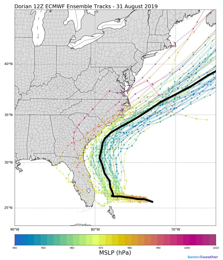
    ECM ensemble in little doubt this will be taking a sharp right turn possibly even before it clears through the Bahamas.

    EDUpffHUcAIr4gY?format=jpg&name=900x900


  • Registered Users Posts: 6,235 ✭✭✭Oneiric 3


    ECMWF 12r looking increasingly concerning for the northern Bahama islands, not only in terms of wind potential, but for rainfall also as this model once again stalls the eye just slightly south of Great Bahama island over a protracted period from late Sun through to early Tues at least.

    New Moon


  • Registered Users Posts: 23,441 ✭✭✭✭Kermit.de.frog


    There is still uncertainty of course. GFS still wants to keep the track nearer the coast and ICON takes the eye right up through Florida.

    This will be a nowcast. Biggest question is when will it make the turn north?


  • Registered Users Posts: 8,219 ✭✭✭Gaoth Laidir


    At the moment the precipitation zone is fairly small and concentrated, with a distinct lack of spiral bands (as shown below). Given the current forecast track, both wind and rain effects in eastern Florida would be fairly limited (gale force winds). We'll probably see this change soon if there's an ERC, but we'd need to see a large change in structure for it to be of major concern.

    Hopefully too the bulk of the Bahamas islands will avoid the worst of it if it continues as forecast. Still, where gets it will certainly get it.

    20190831.2005.f15.x.pct.05LDORIAN.130kts-945mb-261N-740W.077pc.jpg


  • Registered Users Posts: 23,441 ✭✭✭✭Kermit.de.frog


    18z GFS has it just off Florida coast by Tuesday.


    Potentially significant shift back west in terms of impact...particularly in coastal areas.

    https://twitter.com/WeatherOwen/status/1167918062902755332


  • Registered Users Posts: 23,441 ✭✭✭✭Kermit.de.frog


    Mission 26 underway

    recon_NOAA2-2605A-DORIAN.png

    recon_NOAA2-2605A-DORIAN_timeseries.png


  • Registered Users Posts: 8,219 ✭✭✭Gaoth Laidir


    One saving grace is the large area of dry low and mid-level airmass (orange/brown) around the north and west of the storm, which is probably why the western side is a bit eroded on satellite imagery. It should prevent strengthening to Cat 5 over the next 24 hours before it gets to the Bahamas, after which upwelling and whatever terrain there is there should help. The LGEM has the storm motion slowing down from its current 8 knots to 3 knots for about 12 hours, before speeding up again. Not a huge decrease in speed over what it's already at.

    Mid-level water vapour (animate here)
    489614.jpg

    Low-level
    489615.jpg


  • Advertisement
  • Registered Users Posts: 23,441 ✭✭✭✭Kermit.de.frog


    2nd recon mission in the storm simultaneously now with a 3rd collecting data on the steering environment in the storm's outer bands. Important data collection now for midnight models (edit - correction - 6z runs!).


    Mission 26 so far showing no change from earlier in the day. SLP 941, Max SL wind gust on first pass just under 130 kts or 150 mph.

    Second pass will come through northeast eye wall where winds should be even stronger.

    Mission 25

    recon_AF308-2505A-DORIAN.png

    recon_AF308-2505A-DORIAN_timeseries.png


  • Registered Users Posts: 23,441 ✭✭✭✭Kermit.de.frog


    Mission 25 just recorded a surface level wind speed of 164.6 mph (143 kts) in the northwest eye wall.

    Dorian will be a major CAT 5 hurricane in the next update from the NHC. Although seems a bit of a strange correlation given the flight level wind speed data of 145 kts! Should be a lot more distance than that between those figures. Seems suspect, we'll see if the surface level reading holds up in coming passes.


  • Registered Users Posts: 23,441 ✭✭✭✭Kermit.de.frog


    Mission 26 just recorded 150 kts surface level wind in northern eye wall.

    This supports mission 25 readings and is even higher.

    CAT 5 at next NHC advisory.


  • Registered Users Posts: 8,219 ✭✭✭Gaoth Laidir


    Mission 26 just recorded 150 kts surface level wind in northern eye wall.

    This backs mission 25 readings and is even higher.

    CAT 5 at next NHC advisory.

    That value was 149 knots and has been flagged suspect. The NHC has just updated but has stuck with its earlier 150 mph. We'll see what the next datapoints out say.


  • Registered Users Posts: 9,233 ✭✭✭sdanseo


    Still Cat 4 in the 8pm EDT (15 mins ago)


  • Registered Users Posts: 8,219 ✭✭✭Gaoth Laidir


    That value was 149 knots and has been flagged suspect. The NHC has just updated but has stuck with its earlier 150 mph. We'll see what the next datapoints out say.

    There was a 148 knots 30 seconds before that, and this has not been flagged, so it could well be Cat 5 now.
    000230 2630N 07443W 7526 02368 9887 +135 +135 085105 109 083 018 00
    000300 2628N 07443W 7526 02337 9845 +144 +137 086114 117 091 028 00
    000330 2626N 07443W 7507 02322 9803 +142 //// 085117 120 098 033 01
    000400 2624N 07443W 7510 02272 9750 +144 //// 084125 130 113 032 01
    000430 2622N 07443W 7507 02205 9673 +142 //// 082139 142 132 070 01
    000500 2621N 07443W 7471 02139 9563 +147 //// 082127 136 148 056 01
    000530 2619N 07443W 7515 02027 9462 +181 +168 081080 099 149 045 03
    000600 2617N 07443W 7513 01996 9426 +184 +171 080044 050 057 002 00
    000630 2615N 07443W 7531 01957 9407 +186 +173 082024 029 037 000 03
    000700 2613N 07442W 7530 01957 9405 +183 +173 057008 012 028 000 00
    000730 2610N 07442W 7530 01959 9410 +183 +169 272009 015 028 000 00
    000800 2608N 07442W 7524 01984 9425 +183 +171 263027 035 045 000 00
    000830 2606N 07442W 7519 02010 9449 +182 +165 261057 076 072 007 00
    000900 2605N 07442W 7545 02042 9508 +186 +168 261105 117 121 032 03
    000930 2603N 07442W 7550 02127 9624 +160 //// 263119 122 118 030 05
    001000 2601N 07442W 7564 02185 9714 +154 //// 265110 113 107 012 01
    001030 2600N 07442W 7524 02290 9779 +147 //// 268099 101 099 005 01
    001100 2558N 07442W 7526 02328 9827 +147 //// 268087 089 088 012 01


  • Registered Users Posts: 23,441 ✭✭✭✭Kermit.de.frog


    That value was 149 knots and has been flagged suspect. The NHC has just updated but has stuck with its earlier 150 mph. We'll see what the next datapoints out say.

    I think it's cast iron that the NHC will either issue intermediate advisory or upgrade to CAT 5 at next scheduled advisory.

    The top data point is marked suspect but the one immediately prior is considered valid and that's 148 kts. Mission 25 was also well in CAT 5 territory (143 kts) and that was in the northwest eye wall.

    (edit just seen your updated post)


  • Registered Users Posts: 8,219 ✭✭✭Gaoth Laidir


    26 has just passed back through the eye from the northeast but only found max 133 knots in the NE eyewall. As the storm is moving westwards it figures that the strongest winds will be in the northern eyewall, which has been the case.


  • Registered Users Posts: 1,475 ✭✭✭Jpmarn


    The latest gfs run on netweather.tv has the remnants of this hurricane coming our direction by Tuesday the 10th.


  • Advertisement
  • Registered Users Posts: 23,441 ✭✭✭✭Kermit.de.frog


    26 has just passed back through the eye from the northeast but only found max 133 knots in the NE eyewall. As the storm is moving westwards it figures that the strongest winds will be in the northern eyewall, which has been the case.

    hmmm that data looks a bit dodgy though just at the crucial time. 26 is making it's next pass. Be interesting to see the reading from the northwestern eye wall.


Advertisement