Advertisement
If you have a new account but are having problems posting or verifying your account, please email us on hello@boards.ie for help. Thanks :)
Hello all! Please ensure that you are posting a new thread or question in the appropriate forum. The Feedback forum is overwhelmed with questions that are having to be moved elsewhere. If you need help to verify your account contact hello@boards.ie
Hi all,
Vanilla are planning an update to the site on April 24th (next Wednesday). It is a major PHP8 update which is expected to boost performance across the site. The site will be down from 7pm and it is expected to take about an hour to complete. We appreciate your patience during the update.
Thanks all.

Extratropical Storm Ophelia - Technical Analysis Only - MOD NOTE post #1

1838485868789»

Comments

  • Registered Users Posts: 1,030 ✭✭✭Simon Gruber Says


    Full Marx wrote: »
    I've greatly enjoyed this thread, would anyone recommend an accessible book on meteorology for the uninitiated? I'd like to be more up to speed for the next storm thread haha

    Storm Kings by Lee Sandlin is great account of the history of the study of both Tornadoes and Hurricanes, without going into scientific detail.

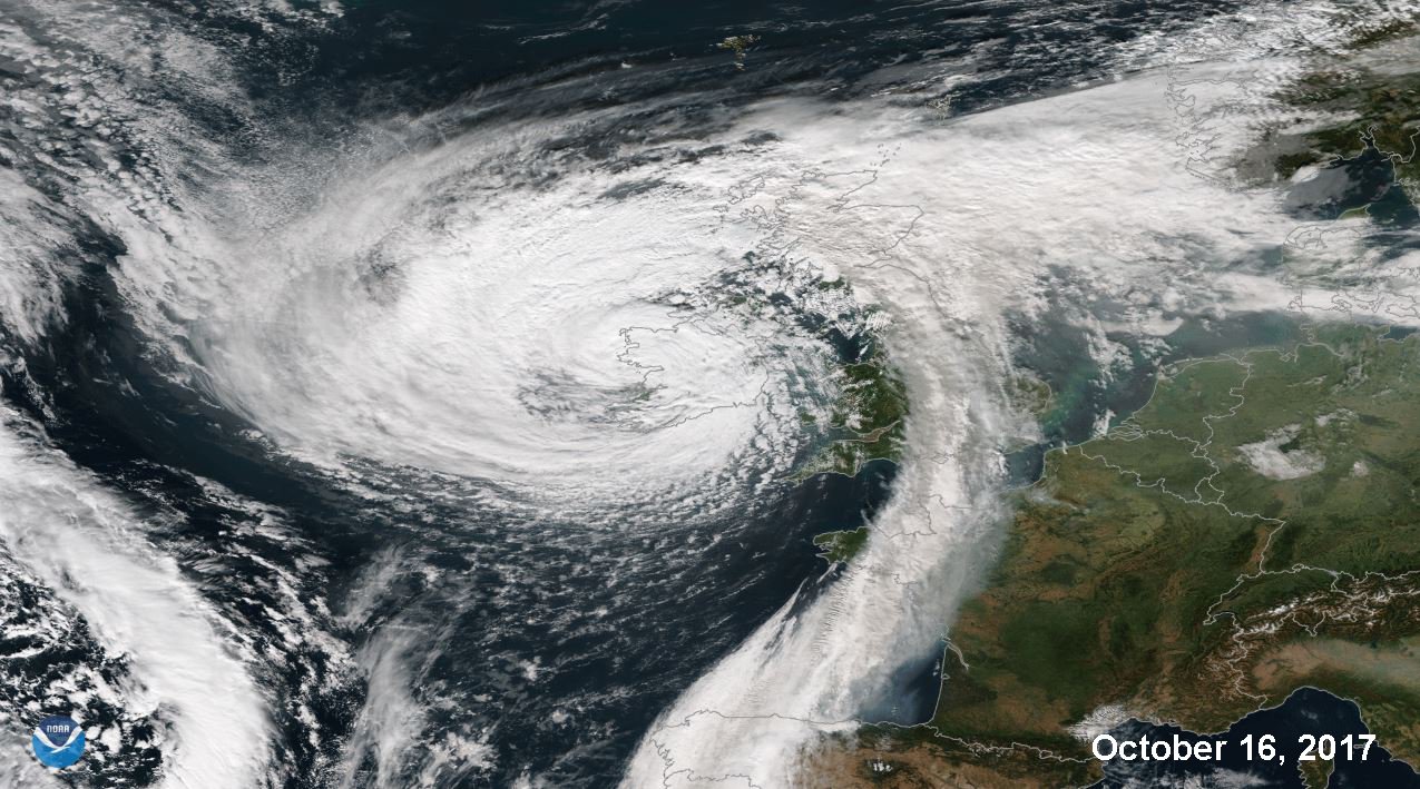
    Here is a great satellite image of Ophelia over Galway Bay

    DMXbHF3X4AAWbnE.jpg:large


  • Registered Users Posts: 4,939 ✭✭✭goat2


    Here near Tralee out by the coast missed the strongest winds and rains. Got a top gust of 85.3 km/h E and was gusting well into the 70's between 10.30 and 12.30 during which I got the strongest gust. Highest 10 min avg was 46.7 km/h at 12.00 ( Anemometer at 7.3m ) .

    Winds from 00.00 to 3.00 NE
    3.00 to 06.00 ENE
    6.00 to 7.30 ESE
    7.30 to 13.30 SE
    13.30 to 18.30 mix of WSW and SW
    18.30 to 0.00 W

    Rain : 8.2mm
    High Temp 16.6C at 8.00 / low 9.8 at 00.00


    Lowest Bar reading 965.8 hPa at 12.30 / 13.00


    No damage done locally to my knowledge apart from branches. Power flickered on and off during the strongest winds .

    Thanks to everyone for their contribution I learnt a lot.


    Pic taken near the eye center at 13.30 approx looking approx SW

    3VChXp4.jpg?1

    NASSA Sat Pic close to that time I reckon.


    PjE637L.jpg?1


    Ijh15Dd.jpg?1

    Yes as eye was over us, the reading on my barometer was also 965, just 20 miles away from you, that was the lowest,, we did not get the trashing most of the country got, we did get trashed by Darwin in 2014, and a little by Desmond, but this time none of that, I am thinking that may be because anything that was going to be uprooted was gone, and the roof being redone due to Darwin, helped greatly, and of course of the scare at that time, we had readied better, scared of what was to come, since this had been reported to be the worst in 50 yrs


  • Registered Users Posts: 8,219 ✭✭✭Gaoth Laidir


    Max 10-minute mean wind 111 kph (60 knots) at Roches Point. Max individual wave 26.1 m.

    https://twitter.com/MetEireann/status/920694785823985664


  • Closed Accounts Posts: 3,220 ✭✭✭cameramonkey


    Max 10-minute mean wind 111 kph (60 knots) at Roches Point. Max individual wave 26.1 m.

    https://twitter.com/MetEireann/status/920694785823985664

    is that the highest wave ever recorded in irish waters?


  • Moderators, Science, Health & Environment Moderators Posts: 11,803 Mod ✭✭✭✭Meteorite58


  • Advertisement
  • Closed Accounts Posts: 6,751 ✭✭✭mirrorwall14


    Any update from Sherkin?


  • Moderators, Society & Culture Moderators Posts: 6,769 Mod ✭✭✭✭nuac


    ............and were there youngsters out in dinghies in Dun Laoire Harbour!


  • Registered Users Posts: 2,021 ✭✭✭Miike


    nuac wrote: »
    ............and were there youngsters out in dinghies in Dun Laoire Harbour!

    http://www.dublinlive.ie/news/dublin-news/storm-brian-dun-laoghaire-rescue-13794445

    What is wrong with people.


  • Registered Users Posts: 18,996 ✭✭✭✭gozunda


    Any update from Sherkin?

    From met.ie

    SHERKIN ISLAND(A)
    21-OCT-2017 for 22:00


    Wind W (Dir) 21 Gust 36 (Kts)
    Weather FAIR
    Temp (c.) 11
    Humidity (%) 73
    Rain (mm) 0.0
    Pressure (hpa) 1014


  • Closed Accounts Posts: 6,751 ✭✭✭mirrorwall14


    gozunda wrote: »
    From met.ie

    SHERKIN ISLAND(A)
    21-OCT-2017 for 22:00


    Wind W (Dir) 21 Gust 36 (Kts)
    Weather FAIR
    Temp (c.) 11
    Humidity (%) 73
    Rain (mm) 0.0
    Pressure (hpa) 1014

    Thank you but I meant for Ophelia, as far as I remember it went offline


  • Advertisement
  • Registered Users Posts: 18,996 ✭✭✭✭gozunda


    Thank you but I meant for Ophelia, as far as I remember it went offline

    Yup it came back and was providing readings up to now afaik ...


  • Registered Users Posts: 8,219 ✭✭✭Gaoth Laidir


    Here's a detailed analysis of Ophelia from start to finish.

    https://irishweatheronline.wordpress.com/2017/11/03/hurricane-ophelia-a-detailed-analysis/


  • Registered Users Posts: 8,219 ✭✭✭Gaoth Laidir


    Strangely, the data seem to be recovered from both Sherkin Island and Cork Airport (see here), but Roches Point is still showing stronger winds than Sherkin. This seems strange, given that Sherkin is much closer to Fastnet and more in line with the core of strongest winds.

    Max 10-minute mean speed (not necessarily from hourly report)
    Roches Point: 62 knots
    Sherkin: 57 knots

    Max gust
    Roches Point: 84 knots
    Sherkin: 74 knots

    The hourly (UTC) reports for Sherkin show:

    Time...Mean...Dir. (°)...SLP (hPa)
    0900...39 kt...160......982.7
    1000...47 kt...150......974.5
    1100...52 kt...170......975.1
    1200...45 kt...210......982.1
    1300...37 kt...230......987.3


  • Registered Users Posts: 8,219 ✭✭✭Gaoth Laidir


    I see the NHC have put the Fastnet Lighthouse anemometer height as 656 ft amsl (200 metres) in their storm summary. I thought it was a lot lower than that. It puts its high windspeed in perspective if it is correct.

    https://www.nhc.noaa.gov/data/tcr/index.php?season=2017&basin=atl


  • Registered Users Posts: 9,233 ✭✭✭sdanseo


    I see the NHC have put the Fastnet Lighthouse anemometer height as 656 ft amsl (200 metres) in their storm summary. I thought it was a lot lower than that. It puts its high windspeed in perspective if it is correct.

    https://www.nhc.noaa.gov/data/tcr/index.php?season=2017&basin=atl

    Not a chance the anemometer is at 200m. The light is at 49m and the tower itself tops out at 54m. The yanks no doubt getting confused by non-imperial units again.

    http://www.irishlights.ie/tourism/our-lighthouses/fastnet.aspx
    Height of Tower:

    54 metres

    Height of Light MHWS:

    49 metres


  • Registered Users Posts: 8,219 ✭✭✭Gaoth Laidir


    The EUMeTrain site has a nice satellite and model analysis of Hurricane Ophelia. There is even a forecasting simulator in which you simulate a Met Éireann forecaster in the run-up to its arrival in Ireland. The clock starts at the start of your shift and runs at speed x20. At various stages you will see tasks appear on the left, which you will need to complete (e.g. analysis, issuing warnings, etc.).

    http://eumetrain.org/resources/Ophelia_2017.htm


Advertisement