Advertisement
If you have a new account but are having problems posting or verifying your account, please email us on hello@boards.ie for help. Thanks :)
Hello all! Please ensure that you are posting a new thread or question in the appropriate forum. The Feedback forum is overwhelmed with questions that are having to be moved elsewhere. If you need help to verify your account contact hello@boards.ie
Hi all,
Vanilla are planning an update to the site on April 24th (next Wednesday). It is a major PHP8 update which is expected to boost performance across the site. The site will be down from 7pm and it is expected to take about an hour to complete. We appreciate your patience during the update.
Thanks all.

2020 Hurricane Season (Atlantic & East Pacific)

1246711

Comments

  • Registered Users Posts: 8,219 ✭✭✭Gaoth Laidir


    sdanseo wrote: »
    Never seen NHC use the term "unsurvivable" before. Think maybe they feel this one has crept up on them as it was a TS for so long and now within <24hrs it's gone from that to Cat 4.
    Remarkable explosive cyclogenesis.


    Imagine 6 metres of water in your garden. That's the height of most semi-detached houses (to the peak of the roof, too).

    This hasn't crept up on them at all. Back on the weekend they were predicting that once passed Cuba there was scope for it to reach major hurricane status and since then they've been more or less consistent, just moving from Cat 3 to 4 in the past day.

    The word unsurvivable most likely refers to the type of terrain where landfall will occur. Thousands of square miles of very low-lying terrain, with the likelihood of major flooding of waterways well inland. Similar area to Katrina, so they want to drive the message home.


  • Registered Users Posts: 8,219 ✭✭✭Gaoth Laidir


    Current intensity is now 125 knots/140 mph. Aircraft recon data at 17:21Z show SFMR reading of 121 kt, flight level wind 131 kt, miniminum pressure 950 hPa.

    524403.png

    20200826.1800.goes17.x.vis1km_high.13LLAURA.120kts-952mb-273N-925W.100pc.jpg


  • Registered Users Posts: 6,235 ✭✭✭Oneiric 3


    One minute satellite animation of 'the eye'.

    https://weather.us/satellite/925-w-279-n/satellite-superhd-1min/20200826-184525z.html#play-0-80-13

    Just looks so pure from above.

    New Moon


  • Registered Users Posts: 8,219 ✭✭✭Gaoth Laidir


    .
    Hurricane Laura Tropical Cyclone Update
    NWS National Hurricane Center Miami FL AL132020
    300 PM CDT Wed Aug 26 2020

    ...300 PM CDT POSITION UPDATE...
    ...CATASTROPHIC STORM SURGE, EXTREME WINDS, AND FLASH FLOODING
    EXPECTED ALONG THE NORTHWEST GULF COAST THIS EVENING...
    ...WATER LEVELS RISING ALONG THE COAST OF SOUTHEAST TEXAS AND
    LOUISIANA...

    Water levels are beginning to rise along the coast of Texas. A
    National Ocean Service water level station at Sabine Pass, Texas,
    recently reported about 2.3 feet of inundation above ground level.

    The Eugene Island, Louisiana, NOS station recently measured
    sustained winds of 36 mph (58 km/h) and a gust to 45 mph (72 km/h).


    SUMMARY OF 300 PM CDT...2000 UTC...INFORMATION
    LOCATION...27.6N 92.7W
    ABOUT 175 MI...280 KM SSE OF PORT ARTHUR TEXAS
    ABOUT 175 MI...280 KM S OF LAKE CHARLES LOUISIANA
    MAXIMUM SUSTAINED WINDS...140 MPH...220 KM/H
    PRESENT MOVEMENT...NW OR 315 DEGREES AT 16 MPH...26 KM/H
    MINIMUM CENTRAL PRESSURE...948 MB...27.99 INCHES


  • Registered Users Posts: 8,219 ✭✭✭Gaoth Laidir


    Grim


  • Advertisement
  • Registered Users Posts: 8,219 ✭✭✭Gaoth Laidir


    Current aircraft recon data show SFMR winds of 118 kts and central pressure now 943.2 hPa.

    Latest dropsonde from the northeast eyewall. Surface wind 123 knots.

    recon_AF307-2313A-LAURA_dropsonde12_20200826-2007.png


  • Registered Users Posts: 692 ✭✭✭bazlers


    140MPH sustained winds. What strength of gusts would be expected?


  • Registered Users Posts: 8,219 ✭✭✭Gaoth Laidir


    bazlers wrote: »
    145MPH sustained winds. What strength of gusts would be expected?

    From the sounding above, gusts could be 150 kts (170 mph).


  • Registered Users Posts: 8,219 ✭✭✭Gaoth Laidir


    18Z SHIPS calls for more or less steady winds up to the landfall point at 12 hours. Westerly shear increasing from 9 to 25 knots by then, and hopefully land interaction to the storm's northeast will disrupt the circulation and drag in some dry air. I would go for 110 kts at final landfall.

    http://hurricanes.ral.ucar.edu/realtime/plots/northatlantic/2020/al132020/stext/20082618AL1320_ships.txt


  • Registered Users Posts: 692 ✭✭✭bazlers


    Wow. You would be nearly embarrassed with our little yellow warnings. Crazy wind speed.


  • Advertisement
  • Registered Users Posts: 2,023 ✭✭✭irishrover99


    Worst storm surge in Louisiana since 1957.

    Jake Tapper just now on CNN. “If you are watching this on tv in Louisiana, turn of the tv and get the hell out” 😦


  • Registered Users Posts: 8,219 ✭✭✭Gaoth Laidir


    Now 145 mph/125 kt. It has increased 55 knots in 24 hours, which is not a record for the Gulf. Karl (2010) increased 65 knots.
    Hurricane Laura Discussion Number 28
    NWS National Hurricane Center Miami FL AL132020
    400 PM CDT Wed Aug 26 2020

    Laura has continued to rapidly strengthen today with recent
    visible satellite imagery revealing a very distinct 25 nautical-
    mile-wide eye embedded in a symmetric central dense overcast. The
    upper-level outflow has also become well established in all
    quadrants. An Air Force Reserve hurricane hunter aircraft that
    is still investigating the hurricane has reported peak 700-mb
    flight-level winds of 136 kt and SFMR winds of 121 kt in the
    northeast eyewall. These data support an initial intensity of
    125 kt, which is an increase of 55 kt over the past 24 hours. The
    minimum pressure has fallen to around 947 mb. The well-defined eye
    is now within range of the NWS Lake Charles WSR-88D radar, and
    hourly Tropical Cyclone Updates began at 1900 UTC (2 PM CDT) and
    will continue through landfall and beyond overnight.

    Laura still has about 12 hours remaining over the warm waters of the
    northwest Gulf of Mexico waters, but increasing southwesterly shear
    around the time of landfall and the possibility of an eyewall
    replacement could result in some fluctuations in intensity this
    evening, but Laura is expected to remain an extremely dangerous
    category 4 hurricane through landfall tonight. Although rapid
    weakening is expected on Thursday as Laura moves inland, the
    hurricane is expected to bring a swath of damaging winds well inland
    over western Louisiana and extreme eastern Texas. The cyclone or
    its remnants are forecast to move off Mid-Atlantic coast over the
    weekend and there remains some possibility that Laura will
    re-intensify as a tropical cyclone offshore of the United States
    east before it merges with a frontal boundary later in the forecast
    period.

    Recent satellite and aircraft fixes show that Laura is moving
    northwestward at about 13 kt. Laura is nearing the western extent
    of a mid-level ridge that is located over the southeastern United
    States. The hurricane should turn north-northwestward this evening
    and northward on Thursday between the ridge and a weak trough over
    the south-central United States. By Friday the cyclone should turn
    northeastward and then east-northeastward as it becomes embedded in
    the mid-latitude westerlies. The track model guidance continues to
    be in good agreement through 72, but there are some forward speed
    differences thereafter. The new NHC track is very close to the
    previous advisory and is near the middle of the guidance envelope.

    Laura is a large hurricane and users are reminded to not focus on
    the precise track forecast since wind, storm surge, and rainfall
    hazards extend far from the center.

    Key Messages:

    1. Unsurvivable storm surge with large and destructive waves will
    cause catastrophic damage from Sea Rim State Park, Texas, to
    Intracoastal City, Louisiana, including Calcasieu and Sabine Lakes.
    This surge could penetrate up to 40 miles inland from the immediate
    coastline, and flood waters will not fully recede for several days
    after the storm.

    2. Hurricane-force winds are expected tonight in portions of the
    hurricane warning area, with catastrophic wind damage expected
    where Laura's eyewall moves onshore. Hurricane-force winds and
    widespread damaging wind gusts will spread well inland into portions
    of extreme eastern Texas and western Louisiana early Thursday.

    3. Widespread flash flooding along small streams, urban areas, and
    roadways is expected to begin this afternoon into Thursday from far
    eastern Texas into Louisiana and Arkansas. This will also lead to
    minor to moderate freshwater river flooding. The heavy rainfall
    threat and flash and urban flooding potential will spread
    northeastward into the middle-Mississippi, lower Ohio, and Tennessee
    Valleys Friday night and Saturday.

    FORECAST POSITIONS AND MAX WINDS

    INIT 26/2100Z 27.9N 92.8W 125 KT 145 MPH
    12H 27/0600Z 29.7N 93.6W 130 KT 150 MPH
    24H 27/1800Z 32.5N 93.5W 60 KT 70 MPH...INLAND
    36H 28/0600Z 34.8N 92.7W 35 KT 40 MPH...INLAND
    48H 28/1800Z 36.5N 90.1W 25 KT 30 MPH...INLAND
    60H 29/0600Z 37.3N 85.6W 25 KT 30 MPH...INLAND
    72H 29/1800Z 38.0N 79.0W 30 KT 35 MPH...POST-TROP/REMNT LOW
    96H 30/1800Z 43.2N 64.0W 45 KT 50 MPH...POST-TROP/EXTRATROP
    120H 31/1800Z 51.0N 49.0W 45 KT 50 MPH...POST-TROP/EXTRATROP


  • Registered Users Posts: 14,244 ✭✭✭✭leahyl


    When is it expected to hit?


  • Registered Users Posts: 195 ✭✭gothwalk


    leahyl wrote: »
    When is it expected to hit?

    It looks like around 06:00 Thursday, our time. So midnight-ish local.


  • Registered Users Posts: 4,497 ✭✭✭auspicious


    What's the sudden increase in intensity down to?


  • Registered Users Posts: 4,670 ✭✭✭endainoz


    Live video from Galveston, even though it doesn't seem to be in the direct path of it. I suppose they are expecting high Strom surges?

    https://youtu.be/-GY0tvPxH9g


  • Registered Users Posts: 20,336 ✭✭✭✭Rikand


    auspicious wrote: »
    What's the sudden increase in intensity down to?

    Very low wind shear and warm sea surface temperatures. A perfect combination for a storm like this


  • Moderators, Recreation & Hobbies Moderators Posts: 11,053 Mod ✭✭✭✭igCorcaigh


  • Banned (with Prison Access) Posts: 1,075 ✭✭✭smellyoldboot


    Will the remnants make it across to us/will there be anything left of her at that stage?


  • Moderators, Recreation & Hobbies Moderators Posts: 11,053 Mod ✭✭✭✭igCorcaigh


    Will the remnants make it across to us/will there be anything left of her at that stage?

    Yes, no.

    I think one of the more insightful (than me) posters commented on this?

    Cannot remember who or where.


  • Advertisement
  • Moderators, Recreation & Hobbies Moderators Posts: 11,053 Mod ✭✭✭✭igCorcaigh


    You can follow Jeff for video updates.

    https://twitter.com/Jeff_Piotrowski


  • Registered Users Posts: 8,219 ✭✭✭Gaoth Laidir


    Latest recon just after midnight found SFMR surface wind of 133 kts, flight level 140 kt and surface pressure 937.4 hPa

    524431.JPG


  • Registered Users Posts: 8,219 ✭✭✭Gaoth Laidir


    auspicious wrote: »
    What's the sudden increase in intensity down to?

    High ocean heat content, low shear, humid mid levels. Perfect conditions for intensification, but shear is increasing now.


  • Registered Users Posts: 8,219 ✭✭✭Gaoth Laidir


    Wow.

    524432.png


  • Registered Users Posts: 8,219 ✭✭✭Gaoth Laidir


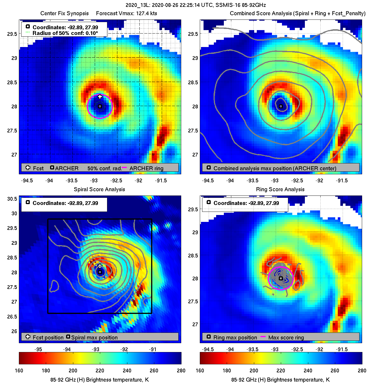
    Latest microwave shows possible effects of westerly shear eroding the western eyewall.

    diag20200826T222514_ssmis16_85.png

    50-knot winds were getting onto the coast at 21Z, though no such winds have been measured by land stations yet. Peak gusts are only around 40-50 mph, with a a 70 mph recorded on the Marsh Oil platform, 224 ft above the sea

    https://www.wrh.noaa.gov/map/?&zoom=7&scroll_zoom=true&center=29.50,-98.00&basemap=OpenStreetMap&boundaries=true,true&obs=true&obs_type=weather&elements=temp,wind,gust&obs_popup=false&obs_density=2

    2020al13_mpsatwnd_202008262100_swhr.gif


  • Registered Users Posts: 8,219 ✭✭✭Gaoth Laidir


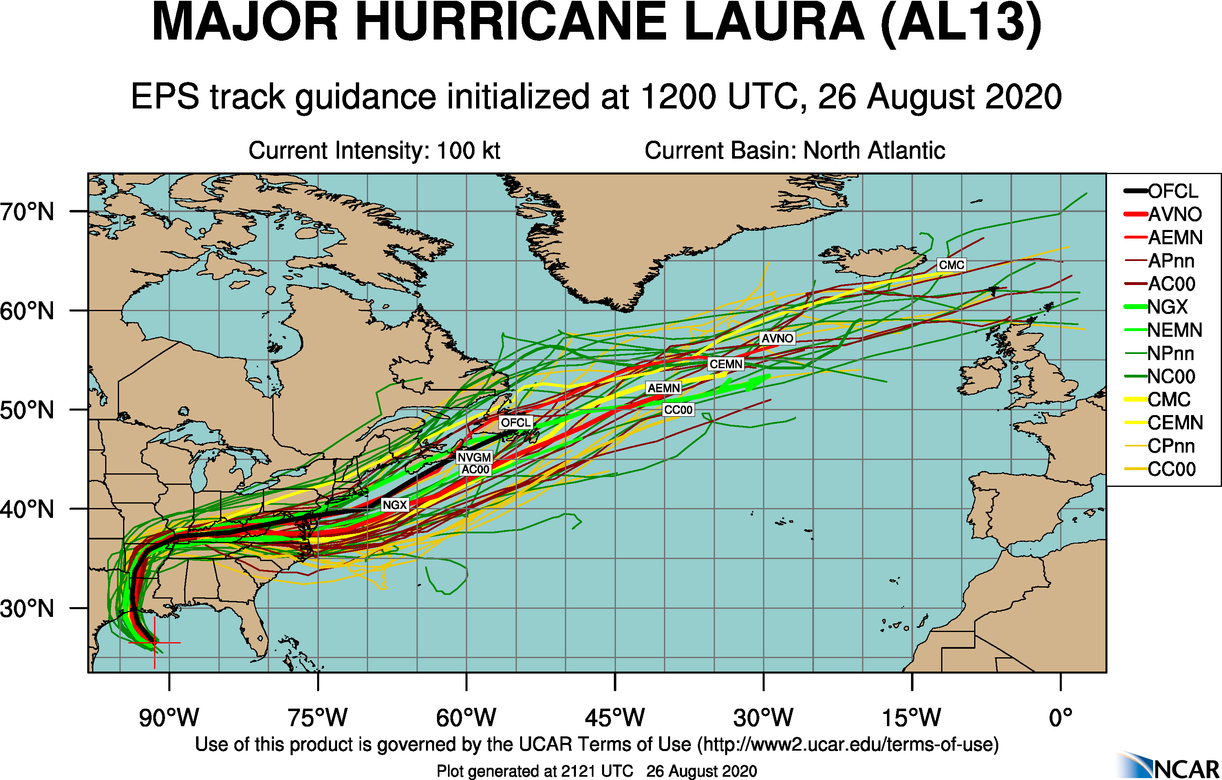
    Will the remnants make it across to us/will there be anything left of her at that stage?

    Take this with a pinch of salt...

    aal13_2020082612_eps_track_by_model_late.png


  • Registered Users Posts: 8,219 ✭✭✭Gaoth Laidir


    Latest dropsonde into the northeast eyewall found surface winds around 128 knots. Average of bottom 150 metres 137 kts.

    recon_NOAA2-2413A-LAURA_dropsonde6_20200826-2301.png


  • Registered Users Posts: 1,766 ✭✭✭Bsal


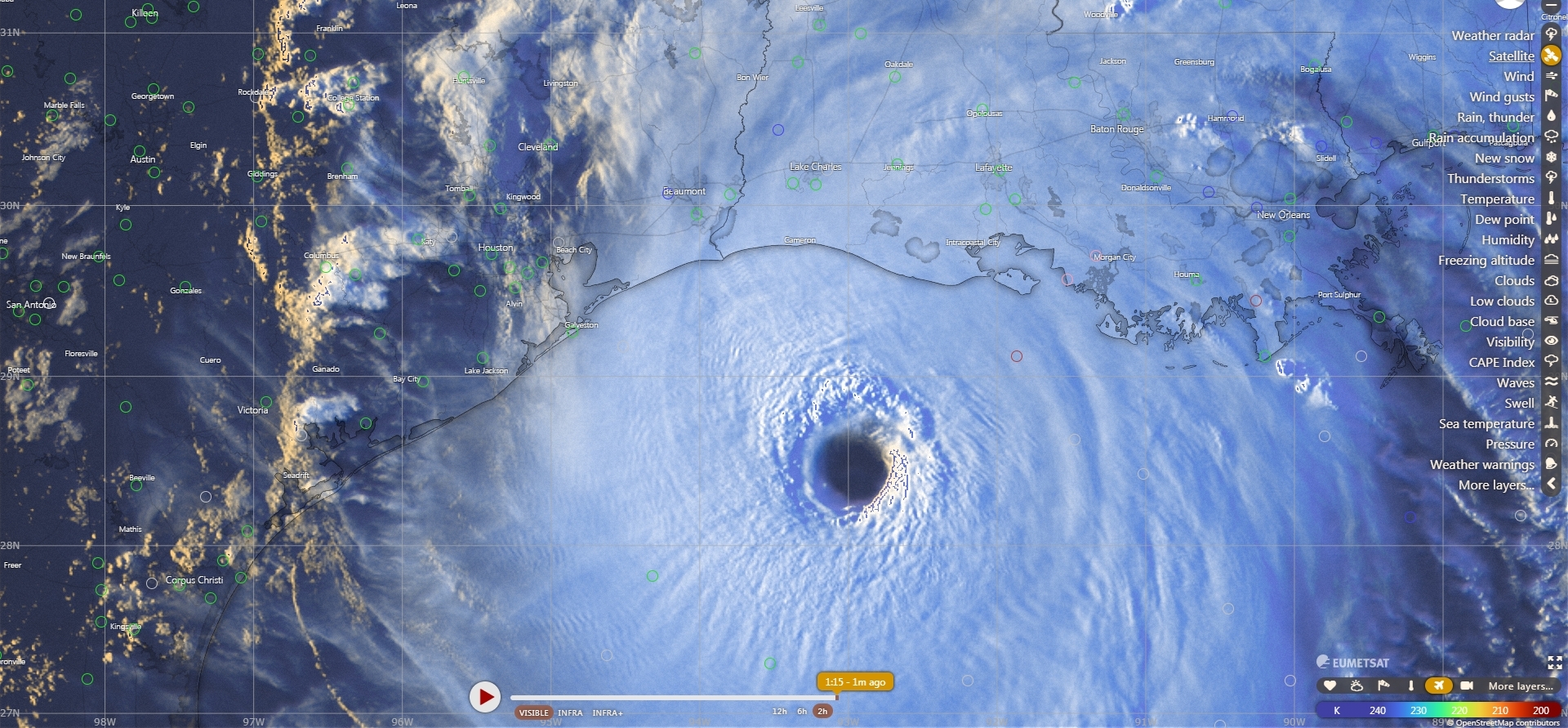
    Looks incredible on satellite

    7791fc4cf9746d5bc5c3657e5329e58d.jpg


  • Registered Users Posts: 17,797 ✭✭✭✭hatrickpatrick


    Rapid Intensification really is both a spectacular and terrifying thing to witness. I wish we saw more of this out in the open Atlantic where it can't do anyone any harm, and far less of it in areas such as the Caribbean and Gulf where the storms go on to cause so much devastation to peoples' lives.

    The price one pays for being a weather enthusiast is tracking and monitoring
    the development of storms like these and knowing exactly what it means for anyone living in its path :(


  • Advertisement
  • Registered Users Posts: 4,497 ✭✭✭auspicious


    Rikand wrote: »
    Very low wind shear and warm sea surface temperatures. A perfect combination for a storm like this

    Thanks.
    I'm guessing the average temperature of the gulf in August year on year is around the same as it is today 30c. So that would be a commonality of nearly all previous hurricanes in the region. Does this mean that the low wind shear is actually the main catalyst driving the intensity?


Advertisement