Advertisement
If you have a new account but are having problems posting or verifying your account, please email us on hello@boards.ie for help. Thanks :)
Hello all! Please ensure that you are posting a new thread or question in the appropriate forum. The Feedback forum is overwhelmed with questions that are having to be moved elsewhere. If you need help to verify your account contact hello@boards.ie
Hi all,
Vanilla are planning an update to the site on April 24th (next Wednesday). It is a major PHP8 update which is expected to boost performance across the site. The site will be down from 7pm and it is expected to take about an hour to complete. We appreciate your patience during the update.
Thanks all.

Interesting Maps

11011131516233

Comments

  • Closed Accounts Posts: 1,148 ✭✭✭Salary Negotiator


    Irish Language 1871
    Irishin1871.jpg

    Any know why there's such a high number in the Dundalk, Cooley, Newry area?


  • Registered Users Posts: 1,382 ✭✭✭FFVII


  • Registered Users Posts: 4,597 ✭✭✭dan1895


    https://images.app.goo.gl/vXvKysL6Z7TnzSU17

    Transport map of the fictional Island if Sodor


  • Registered Users Posts: 4,994 ✭✭✭c.p.w.g.w


    Any know why there's such a high number in the Dundalk, Cooley, Newry area?

    Is this a serious question?

    Its because those are area's with large republican populations


  • Registered Users Posts: 4,672 ✭✭✭ablelocks


    c.p.w.g.w wrote: »
    Is this a serious question?

    Its because those are area's with large republican populations

    ah ffs. is that a serious statement?


  • Advertisement
  • Registered Users Posts: 2,492 ✭✭✭ArnoldJRimmer


    0be77aac385148648e3d2e7c5dba4a87.png


  • Moderators, Politics Moderators Posts: 38,783 Mod ✭✭✭✭Seth Brundle


    share-of-deaths-homicides_v1_850x600.svg


  • Moderators, Politics Moderators Posts: 38,783 Mod ✭✭✭✭Seth Brundle


    vaccine_confidence_map_1280.jpg?itok=fe_xmHnE


  • Registered Users Posts: 13,989 ✭✭✭✭retalivity


    Any know why there's such a high number in the Dundalk, Cooley, Newry area?

    Cooley - Think its the same reason as a concentration in the west and other areas like the middle of derry - remote, mountainous terrain, bad land, no garrison towns nearby etc, allowing 'native' irish culture to persist


  • Closed Accounts Posts: 2,779 ✭✭✭1o059k7ewrqj3n


    Any know why there's such a high number in the Dundalk, Cooley, Newry area?

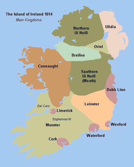
    I think that area was once referred to as Oriel or Airgalla in Irish. Was an Irish kingdom. Held out until the 1500s. I imagine the mountains being poorer land made it one of the few places Irish speakers hadn’t been dispossessed from.


  • Advertisement
  • Registered Users Posts: 3,370 ✭✭✭Ryath


    Steyr 556 wrote: »
    I think that area was once referred to as Oriel or Airgalla in Irish. Was an Irish kingdom. Held out until the 1500s. I imagine the mountains being poorer land made it one of the few places Irish speakers hadn’t been dispossessed from.

    Oriel looks like was a bit further north around Armagh

    Www.wesleyjohnston.com-users-ireland-maps-historical-map1014.gif

    Ireland Seven provinces and it's Clans/Family's.
    Ireland_early_peoples_and_politics.gif


  • Banned (with Prison Access) Posts: 391 ✭✭Professor Genius


    share-of-deaths-homicides_v1_850x600.svg

    Surprised Eire is higher than UK


  • Posts: 0 [Deleted User]


    Ryath wrote: »
    Oriel looks like was a bit further north around Armagh

    True, but the Oriel Trail is on the Cooley peninsula and Port Oriel is north of Clogherhead?? Does that have any bearing on it?


  • Closed Accounts Posts: 1,148 ✭✭✭Salary Negotiator


    retalivity wrote: »
    Cooley - Think its the same reason as a concentration in the west and other areas like the middle of derry - remote, mountainous terrain, bad land, no garrison towns nearby etc, allowing 'native' irish culture to persist

    Makes sense, but there was a concerted effort to displace the native Irish to Connaught, I’ve never heard of anything similar wrt Cooley.
    Steyr 556 wrote: »
    I think that area was once referred to as Oriel or Airgalla in Irish. Was an Irish kingdom. Held out until the 1500s. I imagine the mountains being poorer land made it one of the few places Irish speakers hadn’t been dispossessed from.

    I knew of it being called Oriel, Dundalk’s football pitch is called Oriel Park, it’s just such an outlier compared to the areas surrounding it.

    I was always told that the pale ended in the middle of Dundalk, a few hundred meters south of the river, but that area on the map seems to go well south of Dundalk.


  • Registered Users Posts: 78,234 ✭✭✭✭Victor


    Surprised Eire is higher than UK

    Lower total death rate, but higher homicide rate.


  • Closed Accounts Posts: 1,148 ✭✭✭Salary Negotiator


    c.p.w.g.w wrote: »
    Is this a serious question?

    Its because those are area's with large republican populations

    And was that the case in 1870 more than 50 years before the border was imposed on the area?


  • Banned (with Prison Access) Posts: 9,078 ✭✭✭IAMAMORON


    9cc624ed8d0ce1e54d597361ce27d099-52ec6357eab49.gif


  • Banned (with Prison Access) Posts: 9,078 ✭✭✭IAMAMORON


    Ireland_1450.png


  • Moderators, Recreation & Hobbies Moderators Posts: 11,056 Mod ✭✭✭✭igCorcaigh


  • Banned (with Prison Access) Posts: 9,078 ✭✭✭IAMAMORON


    Just for reference it is worth noting that the first map detailing the English and Scottish plantation is drawn before the English Civil War and the subsequent Cromwell invasion in 1649. This invasion was deemed necessary by that phucking animal because he was insecure about the loyalties of the Irish lords of the time. He was in essence ratifying the new English republic, by force where deemed appropriate.

    The second map details the extent of the English Throne prior to the reign of King Henry Viii. The actual king of England in 1450 was Henry V. The war of the roses commenced in 1455 and lasted for 32 years. It would be another 60 years until Henry viii became king in 1509. The protestant reformation in England started in the 1530's.


  • Advertisement
  • Moderators, Politics Moderators Posts: 38,783 Mod ✭✭✭✭Seth Brundle


  • Registered Users Posts: 8,155 ✭✭✭Quantum Erasure


    [in 2003]the Monaghan Association of New York had to stop carrying their traditional map-emblazoned banner on the St Patrick's Day march. A spokesman said: "We had been receiving some jeers and comments as we assembled for the parade in New York and we couldn't understand why. Until someone from the Louth Association pointed out the similarity."


    _38991329_monaghan_iraq.gif


  • Closed Accounts Posts: 5,995 ✭✭✭Ipso


    [in 2003]the Monaghan Association of New York had to stop carrying their traditional map-emblazoned banner on the St Patrick's Day march. A spokesman said: "We had been receiving some jeers and comments as we assembled for the parade in New York and we couldn't understand why. Until someone from the Louth Association pointed out the similarity."


    _38991329_monaghan_iraq.gif

    When tou need the Louth association to save you, things are bad.


  • Registered Users Posts: 1,178 ✭✭✭MY BAD


    IAMAMORON wrote: »
    9cc624ed8d0ce1e54d597361ce27d099-52ec6357eab49.gif
    Imagine been planted in Leitrim :pac:


  • Registered Users Posts: 8,155 ✭✭✭Quantum Erasure


    Imagine been planted in Leitrim :pac:

    shur there's nothing but plantations there now...


  • Registered Users Posts: 11,690 ✭✭✭✭Skylinehead


    Imagine been planted in Leitrim :pac:

    I'm from there, good luck planting anything but grass there :pac:


  • Registered Users Posts: 13,412 ✭✭✭✭Deja Boo


    The Cheese map from taste atlas...
    cheese-map.jpeg


  • Registered Users Posts: 1,089 ✭✭✭KAGY


    IAMAMORON wrote: »
    Just for reference it is worth noting that the first map detailing the English and Scottish plantation is drawn before the English Civil War and the subsequent Cromwell invasion in 1649. This invasion was deemed necessary by that phucking animal because he was insecure about the loyalties of the Irish lords of the time. He was in essence ratifying the new English republic, by force where deemed appropriate.
    .
    That was the Downs survey, I posted the maps earlier in the thread. Amazing how accurate they got it with basically a telescope and a protractor
    https://touch.boards.ie/thread/2058035937/9/#post111940397


  • Registered Users Posts: 13,989 ✭✭✭✭retalivity


    IAMAMORON wrote: »
    9cc624ed8d0ce1e54d597361ce27d099-52ec6357eab49.gif

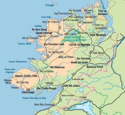
    For Donegal/Tyrconnell, Arranmore and Tory were not planted, in fact there wasnt much land planted west of Letterkenny, thats where all the Irish that remained after the flight of the earls were dispossessed to. Land is/was way too boggy and poor for the planters, so they never bothered with it. Similar story with Mid-derry/tyrone, and the glens of Antrim.
    Hence why it is also, still one of the strongest gaeltachts in the country (Donegal), and there is a strong Gael presence in the other areas as well.


  • Advertisement
  • Banned (with Prison Access) Posts: 9,078 ✭✭✭IAMAMORON


    retalivity wrote: »
    For Donegal/Tyrconnell, Arranmore and Tory were not planted, in fact there wasnt much land planted west of Letterkenny, thats where all the Irish that remained after the flight of the earls were dispossessed to. Land is/was way too boggy and poor for the planters, so they never bothered with it. Similar story with Mid-derry/tyrone, and the glens of Antrim.
    Hence why it is also, still one of the strongest gaeltachts in the country (Donegal), and there is a strong Gael presence in the other areas as well.

    Kind of ironic, it is my understanding that there is very healthy population of Protestant Gaeilgeoir's in west Donegal?

    13_1.jpg


Advertisement