Advertisement
If you have a new account but are having problems posting or verifying your account, please email us on hello@boards.ie for help. Thanks :)
Hello all! Please ensure that you are posting a new thread or question in the appropriate forum. The Feedback forum is overwhelmed with questions that are having to be moved elsewhere. If you need help to verify your account contact hello@boards.ie
Hi all,
Vanilla are planning an update to the site on April 24th (next Wednesday). It is a major PHP8 update which is expected to boost performance across the site. The site will be down from 7pm and it is expected to take about an hour to complete. We appreciate your patience during the update.
Thanks all.

Interesting Maps

19293959798233

Comments

  • Moderators, Recreation & Hobbies Moderators, Science, Health & Environment Moderators, Technology & Internet Moderators Posts: 90,660 Mod ✭✭✭✭Capt'n Midnight


    Hz0Wo0r.jpg


  • Registered Users Posts: 11,646 ✭✭✭✭El Weirdo


    Part of Ballina today was in Co Sligo too, not sure why the boundaries changed there .

    They can keep it.


  • Registered Users Posts: 78,234 ✭✭✭✭Victor


    Actually, if they put a couple of emus out on the wings they might do a lot better against the All Blacks.
    Emu wings aren't very good.


  • Registered Users Posts: 16,109 ✭✭✭✭Pherekydes


    Victor wrote: »
    Emu wings aren't very good.

    Have you ever tried them? I'd say they'd be delish roasted in a sweet bbq sauce. How many could you get through? 6 maybe...


  • Registered Users Posts: 4,376 ✭✭✭KevRossi


    They have a battle marked down in Edinburgh around 2012. What was that about?
    First battle in Ireland in Donegal around 560 A.D. That's not true.
    Troubles in N.I. marked as a battle as well.

    It's very Euro-American centric, but it just deals with the ones in Wikipedia so the source and accuracy is somewhat limited.

    Interesting all the same to see Napoleon, WWI and WWII on it, looks like some threw a scattering of pebbles onto the map and doesn't show the suffering that went on there.

    EDIT: Misses out on a number of conflicts that are actually listed in Wikipedia, especially conflicts in Africa.


  • Advertisement
  • Registered Users Posts: 266 ✭✭stopthevoting


    McGaggs wrote: »
    A friend of mine has his postal address as Drogheda, Co Meath.

    He lives in Co.Meath, but his POSTAL address is actually Drogheda, Co.Louth. You can check this on the Eircode website.

    It's not because of historical changing of county boundaries.
    It's because Drogheda is the Post Town for his area. The next line in the address after the Post Town is the county of the Post Town, which in this case is Co.Louth. There are many other places like this around the country which have an address with a Post Town in a different county.

    Many people use incorrect postal addresses but their post still gets delivered. This also happened long before Eircodes were introduced.

    By the way, the county line is supposed to be omitted in an address where the name of the county is the same as the name of the town, eg; Cavan, Monaghan, Galway, Limerick.
    Some organisations follow this rule, such as VHI for their Kilkenny address on their website, and the Pensions Authority for their Sligo adddress, but other don't, such as Liberty Insurance for their Cavan address;
    https://www.vhi.ie/contact
    https://www.pensionsauthority.ie/en/contact_us/
    https://www.libertyinsurance.ie/contact-us


  • Moderators, Category Moderators, Arts Moderators, Sports Moderators Posts: 48,234 CMod ✭✭✭✭magicbastarder


    my parents in law live in county dublin, near ashbourne, but as per the above, if they are sent a letter addressed to county dublin it usually takes a little longer to arrive as ashbourne is their local post office.


  • Moderators, Category Moderators, Music Moderators, Regional East Moderators, Regional Midlands Moderators, Regional Midwest Moderators, Regional Abroad Moderators, Regional North Mods, Regional West Moderators, Regional South East Moderators, Regional North East Moderators, Regional North West Moderators, Regional South Moderators Posts: 8,007 CMod ✭✭✭✭Gaspode


    Of course, there is no County Dublin, just Dublin.


  • Moderators, Recreation & Hobbies Moderators, Science, Health & Environment Moderators, Technology & Internet Moderators Posts: 90,660 Mod ✭✭✭✭Capt'n Midnight


    He lives in Co.Meath, but his POSTAL address is actually Drogheda, Co.Louth. You can check this on the Eircode website.
    Eircodes are not postcodes ;)


  • Registered Users Posts: 266 ✭✭stopthevoting


    Gaspode wrote: »
    Of course, there is no County Dublin, just Dublin.


    English | Gaeilge DONABATE POST OFFICE
    DONABATE TOWN CENTRE
    MAIN STREET
    DONABATE
    CO. DUBLIN
    K36 VC59


  • Advertisement
  • Registered Users Posts: 8,901 ✭✭✭Gregor Samsa


    Eircodes are not postcodes ;)

    The Eircode website gives a Geographic Address and a Postal Address for each Eircode. For most people, these are the same, but for some near a county border, they might be different.

    For example, A92 XV9K gives the Geographic Address as DROGHEDA, CO. MEATH, but the postal address as DROGHEDA, CO. LOUTH. The house next door to it has both addresses as Co. Louth.


  • Registered Users Posts: 266 ✭✭stopthevoting


    Eircodes are not postcodes ;)


    Firstly, I didn't say that. I said that you can use the Eircode website to check addresses.
    Secondly, even if it not a required part of an address it is still a postcode.

    "Eircode, Ireland’s postcode system launched in July 2015."
    "Eircode is the name that has been chosen for the national postcode system in Ireland."


  • Posts: 7,712 ✭✭✭[Deleted User]


    It also works like a dream despite everyone wanting us to use a UK system.


  • Registered Users Posts: 3,583 ✭✭✭chooseusername


    KevRossi wrote: »
    They have a battle marked down in Edinburgh around 2012. What was that about?
    Aftermath of the famous scottish cup final between Hearts And Hibs?:D
    The streets of Edinburgh ran red with Irn-Bru


  • Registered Users Posts: 4,431 ✭✭✭Sky King


    Eircodes are not postcodes ;)

    They basically are. Eircodes were devised to make postal distribution more efficient, that's why the map of them initially appears to be slightly illogical - it's aligned with our postal system which often ignores county borders etc.

    https://www.autoaddress.ie/images/default-source/Blog/rkdraft002e477a3b6a6e538fdaff0000b6b9f2.png?sfvrsn=2


  • Registered Users Posts: 2,512 ✭✭✭yagan


    Sky King wrote: »
    They basically are. Eircodes were devised to make postal distribution more efficient, that's why the map of them initially appears to be slightly illogical - it's aligned with our postal system which often ignores county borders etc.

    https://www.autoaddress.ie/images/default-source/Blog/rkdraft002e477a3b6a6e538fdaff0000b6b9f2.png?sfvrsn=2
    Eircodes are site specific, whereas postcodes as used in the USA, UK, Aus and elsewhere in the world are local specific with varying degrees of proximity.

    For example a UK postcode will be street specific, whereas US and Oz postcodes will only cover a town/city administrative area.


  • Registered Users Posts: 8,901 ✭✭✭Gregor Samsa


    yagan wrote: »
    Eircodes are site specific, whereas postcodes as used in the USA, UK, Aus and elsewhere in the world are local specific with varying degrees of proximity.

    For example a UK postcode will be street specific, whereas US and Oz postcodes will only cover a town/city administrative area.

    That's not using any official definition of a "postcode", though is it? Just because the postcode systems in other countries have varying levels of geographic specificity doesn't mean that a system that is very specific isn't a postcode.

    One definition of a postcode is "a group of numbers or letters and numbers which are added to a postal address to assist the sorting of mail." There's nothing in there that says that if they're too specific, they can't be a postcode. The question - and it's a very pedantic one really - is whether they're used for sorting mail or not.

    Another definition of a postcode is "a short series of letters and numbers that is part of an address, and shows exactly where a place is". An Eircode is certainly covered by that.


  • Registered Users Posts: 4,376 ✭✭✭KevRossi


    *Sigh

    A map of Eircodes in Ireland. Click for hi-res.

    rkdraft002e477a3b6a6e538fdaff0000b6b9f2.png?sfvrsn=2


  • Registered Users Posts: 21,517 ✭✭✭✭Tell me how


    yagan wrote: »
    Eircodes are site specific, whereas postcodes as used in the USA, UK, Aus and elsewhere in the world are local specific with varying degrees of proximity.

    For example a UK postcode will be street specific, whereas US and Oz postcodes will only cover a town/city administrative area.

    I'm still not sure what you are saying here. What is the difference between 'site' and 'local'?


  • Registered Users Posts: 40,102 ✭✭✭✭ohnonotgmail


    I'm still not sure what you are saying here. What is the difference between 'site' and 'local'?

    eircodes cover one address. us and uk codes cover multiple addresses in an area.


  • Advertisement
  • Registered Users Posts: 8,450 ✭✭✭blackwhite


    I'm still not sure what you are saying here. What is the difference between 'site' and 'local'?


    Eircode are unique to each home/property. You put the Eircode in and it gives you the exact site/location.

    In most other countries, a postcode only identifies the local area. In the UK it's typically a street, in France it could cover several blocks in a neighborhood


  • Registered Users Posts: 18,921 ✭✭✭✭BonnieSituation


    eircodes cover one address. us and uk codes cover multiple addresses in an area.
    Indeed

    An eircode covers one business or residential delivery point, ie. A letter box. Other Postal code systems cover larger areas varying from local delivery areas to vast swathes of countryside.

    The UK uses suffixes on their already outdated and clunky system to further refine the granularity of an individual postcode.

    I've many examples of shared rural UK postcodes that are many miles from each other which would be unexpected from a geographical knowledge point of you.

    An eircode is merely a remapping of the building points table of the Geodirectory. [Slightly more to it than that, but that's the essence of it]


  • Registered Users Posts: 6,428 ✭✭✭marcbrophy


    Lads...


  • Moderators, Science, Health & Environment Moderators, Society & Culture Moderators Posts: 6,306 Mod ✭✭✭✭mzungu


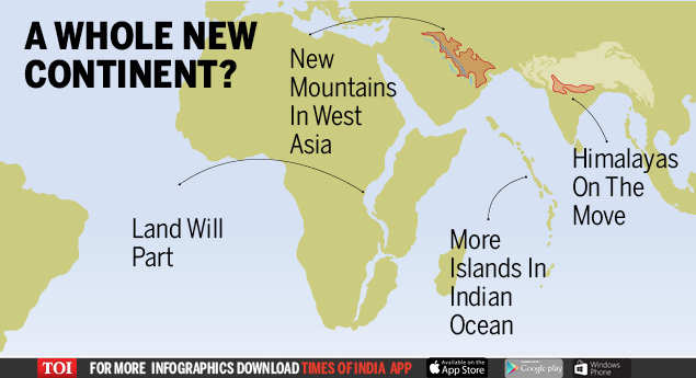
    Ten million years time. (Based on current predictions and data)


    65021432.jpg


  • Moderators, Recreation & Hobbies Moderators, Science, Health & Environment Moderators, Technology & Internet Moderators Posts: 90,660 Mod ✭✭✭✭Capt'n Midnight


    Sky King wrote: »
    They basically are. Eircodes were devised to make postal distribution more efficient,
    Nope. An Post had a computerised system that recognised handwriting. They didn't need postcodes.

    Everyone else did. But they wouldn't share with each other.

    Dublin and Cork kept their postal districts. Beyond that it's semi-random for the 3 digit area and then a random letter and three random alphanumerics but
    0 not O etc.


    eircode1.jpg

    eircode2.jpg


  • Registered Users Posts: 266 ✭✭stopthevoting


    One of the longest possible journeys within a single county in Ireland,
    2hr 59min (or 3hr 7min avoiding tolls),
    according to a post about a challenge to find this journey https://www.corkbeo.ie/news/local-news/cross-cork-three-hour-road-19541313
    A strange thing about the article is that it doesn't even mention Donegal, but it mentions Sligo. "There were attempts to make the case for counties like Mayo, Sligo and Galway as having A to B journeys of a longer distance - but none of them came even close to any number of cross-Rebel County road trips you can do."


  • Registered Users Posts: 11,758 ✭✭✭✭BattleCorp


    One of the longest possible journeys within a single county in Ireland,
    2hr 59min

    I once had a car like that too. :D


  • Moderators, Recreation & Hobbies Moderators, Science, Health & Environment Moderators, Technology & Internet Moderators Posts: 90,660 Mod ✭✭✭✭Capt'n Midnight


  • Registered Users Posts: 5,645 ✭✭✭The J Stands for Jay


    One of the longest possible journeys within a single county in Ireland,
    2hr 59min (or 3hr 7min avoiding tolls),
    according to a post about a challenge to find this journey https://www.corkbeo.ie/news/local-news/cross-cork-three-hour-road-19541313
    A strange thing about the article is that it doesn't even mention Donegal, but it mentions Sligo. "There were attempts to make the case for counties like Mayo, Sligo and Galway as having A to B journeys of a longer distance - but none of them came even close to any number of cross-Rebel County road trips you can do."

    I'd be dubious about Donegal not being featured. Going back to the address discussion above, Lifford is included in the postal address of a lot of the county, including Malin head. According to Google maps, the distance between those two is 86km. Of that's the distance between two parts of a postal address, then I think Donegal could beat a 2h59 drive.


  • Advertisement
  • Registered Users Posts: 13,989 ✭✭✭✭retalivity


    McGaggs wrote: »
    I'd be dubious about Donegal not being featured. Going back to the address discussion above, Lifford is included in the postal address of a lot of the county, including Malin head. According to Google maps, the distance between those two is 86km. Of that's the distance between two parts of a postal address, then I think Donegal could beat a 2h59 drive.

    I remember as kid playing GAA in NW Donegal, being in the same group as Malin & Naomh Columba (Glencolumbcille) for some junior competition. They were far enough from me at the time, but from each other they used to say it would take 3 hours (early 90s donegal roads). Google maps says that they are 146km and 2h15m apart.

    https://goo.gl/maps/M6GtiodJAVRzn1568


Advertisement