Advertisement
If you have a new account but are having problems posting or verifying your account, please email us on hello@boards.ie for help. Thanks :)
Hello all! Please ensure that you are posting a new thread or question in the appropriate forum. The Feedback forum is overwhelmed with questions that are having to be moved elsewhere. If you need help to verify your account contact hello@boards.ie
Hi all,
Vanilla are planning an update to the site on April 24th (next Wednesday). It is a major PHP8 update which is expected to boost performance across the site. The site will be down from 7pm and it is expected to take about an hour to complete. We appreciate your patience during the update.
Thanks all.
Archaeoastronomy at megalithic sites
Comments
-
Excellent work there,
Wish I had the time to do this as I cannot find any information about anyone having done this level of work at Loughcrew.
Has anyone found any more than Basic stories surrounding the Loughcrew cairns?0 -
cfuserkildare wrote: »Excellent work there,
Wish I had the time to do this as I cannot find any information about anyone having done this level of work at Loughcrew.
Has anyone found any more than Basic stories surrounding the Loughcrew cairns?
I would suggest getting a copy of Martin Brennan's 'The Stones of Time':
https://books.google.ie/books?id=AS7hpfq8K1YC&redir_esc=y0 -
I would suggest getting a copy of Martin Brennan's 'The Stones of Time':
https://books.google.ie/books?id=AS7hpfq8K1YC&redir_esc=y
Just ordered, thanks for the recommendation.0 -
I discovered a circular enclosure on satellite imagery several months ago which has since been recorded on the National Monuments Service SMR database. KD023-128--- is situated in tillage approximately 3 km. northeast of the plains of the Curragh in Co. Kildare.

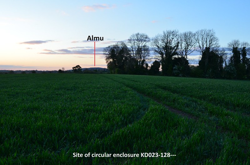
It has commanding views of the Chair hills on the west-northwest horizon and Almu/the Hill of Allen to the north. According to Irish Mythology, Fionn mac Cumhaill had a residence/hillfort on Almu, and the surrounding flatlands were used as training grounds for his band of warriors, the Fianna.
The Chair hills:
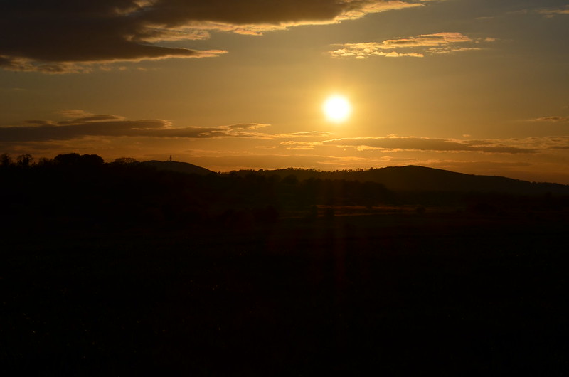
The images below show the sun approaching the summit of Grange hill (the peak on the far right), observed from the site of the circular enclosure KD023-128--- on the evening of May 4th, the evening before the official cross-quarter day of May 5th. The sun will also set at Grange at the August cross-quarter day as the sun continues its journey southward following the Summer solstice:


I hope to post soon on more interesting observations on the Curragh.0 -
KD023-048--- is a large trivallate ring-barrow situated on the eastern edge of the plains of the Curragh, Co. Kildare. It lies less than 150 metres south of the Exit 12 roundabout on the M7 (southbound).
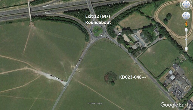
Most who have visited the Curragh would be familiar with the fabulous Fionn mac Cumhaill sculpture on that roundabout:
Trivallate ring-barrow KD023-048----:
When one is standing at this ring-barrow the Chair Hills are very much visible on the horizon to the Northwest:
Lugnaquilla is visible on the horizon to the Southeast:
Where both Lugnaquilla and the Chair Hills lie on the local horizon in relation to KD023-048--- peaked my curiosity. The summer solstice sun sets in the direction of the Chair hills and the winter solstice sun rises in the southeast. I had an inkling that the winter solstice sun would rise up from behind the summit of Lugnaquilla as one observed from ring-barrow KD023-048---. On the 22nd December, 2018, a rather cloudy morning, I took a few photos from the outer bank of KD023-048--- as the sun was rising in the southeast. With the cloudy, overcast conditions I didn't hold out much hope that I'd see anything of significance that morning, but a slight break in the clouds just at the right moment did indeed confirm that the winter solstice sun does rise from Lugnaquilla.
Winter solstice sunrise (2018) observed from KD023-048, with the sun peeping through a break in the clouds as it rises from Lugnaquilla: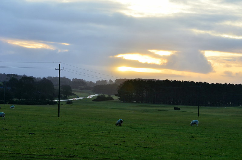
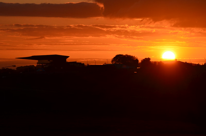
Last week I turned my attentions to the Chair Hills to the Northwest, and on Monday 17th June, I took several images as the sun set that evening while standing close to KD023-048---. Standing at KD023-048--- today, the view of Grange hill (one of the Chair hills) is obscured by trees, so I positioned myself a few hundred metres further along the suspected solstice alignment with a clearer view of Grange (in post #185 directly above this one, I posted images of the May cross-quarter sun setting at the summit of Grange observed from a circular enclosure I discovered recently just outside the Curragh). Although it was four evenings prior to the official solstice, the sun moves very little northwards in that period of time - approximately 0.1° azimuth - so what you see in the images below is very close to what one would see on the evening of the summer solstice on the 21st. (On the evening of the solstice itself, the sky was overcast, and unfortunately didn't manage to capture it).
The setting sun descending behind the summit of Grange hill to the northwest: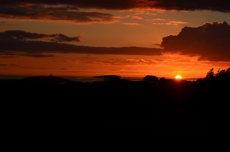
One other curious observation I made in recent years is where the sun sets on the evening of the winter solstice while standing at KD023-048---. On Long hill (now the Curragh military camp) an interesting linear feature was recorded on an 1838 Ordnance Survey Map. It comprised two parallel embankments, approximately 150 metres long and well over 50 metres wide and was recorded as the site of an encampment. Some have suggested this may not have been the site of an encampment, but possibly a Cursus. This linear feature is no longer extant, but I've observed the winter solstice sun setting at what would have been the northwest end of this linear feature when standing at KD023-048---.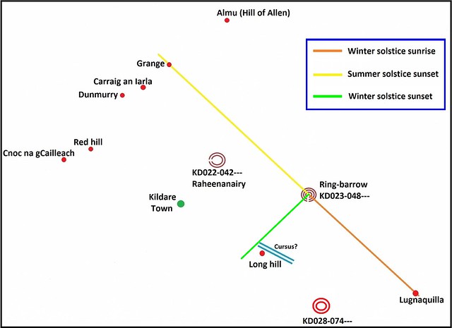
Interestingly enough, while the summer solstice sun is setting behind Grange hill when observing from KD023-048---, the sun is simultaneously setting behind the hill of Dunmurry when observing from ring-barrow KD028-074--- which lies 2.5 kilometres SE-S of KD023-048. Not only that, the solstice alignment from KD028-074 to the summit of the hill of Dunmurry also passes through the northwest end of the ?cursus? on Long hill, so one would see the summer solstice sun setting at the summit of Dunmurry from that spot too. I've posted about my observations of the summer solstice sunset from KD028-074 already in this thread - see post #179.0 -
Advertisement
-
Is it possible that druids would have been consulted prior to the construction of a new settlement, and they might choose sites with certain alignments to bring "luck" or good fortune to the future occupants?
Like a sort of feng shui, to please the gods or the ancestors.0 -
Join Date:Posts: 4956
It’s a possibility but we are looking at monuments that pre-date the druids by a long way!Is it possible that druids would have been consulted prior to the construction of a new settlement, and they might choose sites with certain alignments to bring "luck" or good fortune to the future occupants?
Like a sort of feng shui, to please the gods or the ancestors.0 -
Join Date:Posts: 4956
Great work Hotei...as ever. Really interesting possibilities.
A possible inter-relationship between linear monuments on Brewel Hill and Keadeen mountain was noted by Christiaan Corlett some time ago. The possibility of other lowland/upland relationships is genuinely intriguing.
These are really important observations and really valuable field work.0 -
slowburner wrote: »Great work Hotei...as ever. Really interesting possibilities.
A possible inter-relationship between linear monuments on Brewel Hill and Keadeen mountain was noted by Christiaan Corlett some time ago. The possibility of other lowland/upland relationships is genuinely intriguing.
These are really important observations and really valuable field work.
Thanks SB. I was beginning to think no one really cared!")
Just a correction to my last post - I stated that the cursus-like linear feature on Long hill measured approximately 150 metres long, however, it actually measured just under one kilometre long which made it a pretty substantial structure indeed.
I've attached another illustration below (pretty basic looking and not to scale) showing some other curious alignments related to the cursus-like feature mentioned in the previous post above: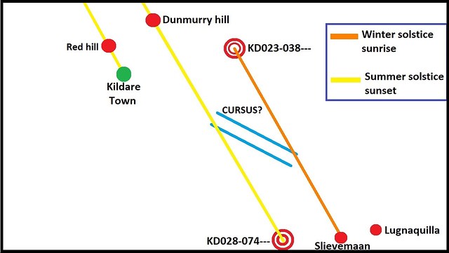
The cursus-like feature sat on Long hill (now site of the Curragh military camp) and had a NW-SE orientation. I mentioned in my previous post that an alignment from ring-barrow KD028-074--- to the summit of Dunmurry hill marked the summer solstice sunset (represented by the yellow line in the above illustration). A closer look shows that this line passes through the NW end (terminus?) of the linear feature on Long hill, so one would also see the summer solstice sun set at the summit of Dunmurry from the terminus too.
Several years ago, myself and baaba maal (another frequenter of this forum) visited ring-ditch KD023-038--- in the hope of seeing the winter solstice sun rise from Slievemaan in the Wicklow mountains to the SE. Although it was a beautiful crisp morning, clouds gathered very quickly on the SE horizon which would later scupper our chances of seeing the sunrise that morning. I managed to capture that sunrise the following year.
Ring-ditch KD023-038--- with a view of the roundtower and cathedral in Kildare town to the SW-W:
The winter solstice sun rising from the summit of Slievemaan (Sliabh meádhon, 'middle mountain') observed from ring-ditch KD023-038---. The higher peak to the left is Lugnaquilla: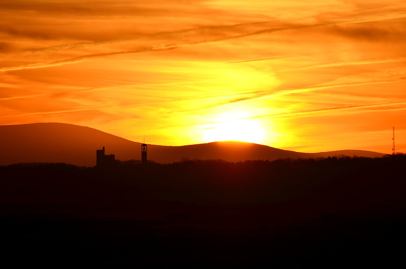

A closer look at the first sunrise image above shows a silhouette of the church spire and fire station on Long hill (Curragh military camp). The cursus-like linear feature recorded on an 1838 Ordnance Survey map, ran for almost a kilometre from just left of the church down past the aerial mast shown on the far right of the image.
If you scroll back up to my rather crude illustration above, you'll see where the orange line representing a winter solstice sunrise alignment from KD023-038--- to the summit of Slievemaan passes directly through the SE terminus of the linear feature on Long hill. Again, when standing at the SE terminus one would also see the sun rise from Slievemaan at winter solstice (I witnessed this myself back in 2015).
The NW-SE orientation of the cursus? is also rather curious in that I discovered it is oriented directly towards the site of St. Brigid's Cathedral and Roundtower in Kildare town to the NW. St. Brigid's was believed to be the site of a pre-Christian fire temple and something I alluded to in an earlier post in this thread - see post #139 (that post is now sadly devoid of images because I have since changed some security settings on my Flickr account, and yes, I was Bonedigger in a former incarnation!).
As I've shown it's possible to observe the winter solstice sun rise from Slievemaan from ring-ditch KD023-038---, but I've also discovered that it's possible to see the setting sun on the evenings of the November and February cross-quarter days (which represented the pagan festivals of Samhain and Imbolc) descend behind the site of St. Brigid's in Kildare town.
November cross-quarter day sunset (2015) observed from ring-ditch KD023-038--- setting at the site of St.Brigid's Cathedral in Kildare town (sunset on the February cross-quarter day will look almost identical):
In post #179, I outlined how it may have been possible that ring-barrow KD028-074--- (shown in the very first illustration above) may have helped mark a period of time from the May cross-quarter day through to the August cross-quarter day, so it's possible ring-ditch KD023-038--- may have played a similar role marking the period of time from the November cross-quarter through to the February cross-quarter. The sun at winter solstice can also be observed setting at the site of St. Brigid's Cathedral from two ring-barrows lying not far from ring-ditch KD023-038--- (see post #139).
Winter solstice sunset at St. Brigid's in Kildare town observed from ring-barrow KD022-043---: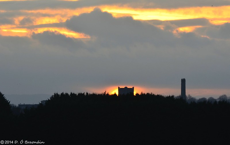 0
0 -
Truly fascinating stuff HM- what is fascinating is that each discovery you make seems to be backed up by the locations of other features. It is like you are unlocking the landscape.
There is definitely a book in this!0 -
Advertisement
-
Thanks very much baaba!0
-
HoteiMarkii wrote: »Thanks SB. I was beginning to think no one really cared!
Just a correction to my last post - I stated that the cursus-like linear feature on Long hill measured approximately 150 metres long, however, it actually measured just under one kilometre long which made it a pretty substantial structure indeed.
I've attached another illustration below (pretty basic looking and not to scale) showing some other curious alignments related to the cursus-like feature mentioned in the previous post above:
The cursus-like feature sat on Long hill (now site of the Curragh military camp) and had a NW-SE orientation. I mentioned in my previous post that an alignment from ring-barrow KD028-074--- to the summit of Dunmurry hill marked the summer solstice sunset (represented by the yellow line in the above illustration). A closer look shows that this line passes through the NW end (terminus?) of the linear feature on Long hill, so one would also see the summer solstice sun set at the summit of Dunmurry from the terminus too.
Several years ago, myself and baaba maal (another frequenter of this forum) visited ring-ditch KD023-038--- in the hope of seeing the winter solstice sun rise from Slievemaan in the Wicklow mountains to the SE. Although it was a beautiful crisp morning, clouds gathered very quickly on the SE horizon which would later scupper our chances of seeing the sunrise that morning. I managed to capture that sunrise the following year.
Ring-ditch KD023-038--- with a view of the roundtower and cathedral in Kildare town to the SW-W:
The winter solstice sun rising from the summit of Slievemaan (Sliabh meádhon, 'middle mountain') observed from ring-ditch KD023-038---. The higher peak to the left is Lugnaquilla:
A closer look at the first sunrise image above shows a silhouette of the church spire and fire station on Long hill (Curragh military camp). The cursus-like linear feature recorded on an 1838 Ordnance Survey map, ran for almost a kilometre from just left of the church down past the aerial mast shown on the far right of the image.
If you scroll back up to my rather crude illustration above, you'll see where the orange line representing a winter solstice sunrise alignment from KD023-038--- to the summit of Slievemaan passes directly through the SE terminus of the linear feature on Long hill. Again, when standing at the SE terminus one would also see the sun rise from Slievemaan at winter solstice (I witnessed this myself back in 2015).
The NW-SE orientation of the cursus? is also rather curious in that I discovered it is oriented directly towards the site of St. Brigid's Cathedral and Roundtower in Kildare town to the NW. St. Brigid's was believed to be the site of a pre-Christian fire temple and something I alluded to in an earlier post in this thread - see post #139 (that post is now sadly devoid of images because I have since changed some security settings on my Flickr account, and yes, I was Bonedigger in a former incarnation!).
As I've shown it's possible to observe the winter solstice sun rise from Slievemaan from ring-ditch KD023-038---, but I've also discovered that it's possible to see the setting sun on the evenings of the November and February cross-quarter days (which represented the pagan festivals of Samhain and Imbolc) descend behind the site of St. Brigid's in Kildare town.
November cross-quarter day sunset (2015) observed from ring-ditch KD023-038--- setting at the site of St.Brigid's Cathedral in Kildare town (sunset on the February cross-quarter day will look almost identical):
In post #179, I outlined how it may have been possible that ring-barrow KD028-074--- (shown in the very first illustration above) may have helped mark a period of time from the May cross-quarter day through to the August cross-quarter day, so it's possible ring-ditch KD023-038--- may have played a similar role marking the period of time from the November cross-quarter through to the February cross-quarter. The sun at winter solstice can also be observed setting at the site of St. Brigid's Cathedral from two ring-barrows lying not far from ring-ditch KD023-038--- (see post #139).
Winter solstice sunset at St. Brigid's in Kildare town observed from ring-barrow KD022-043---:
What would have originally stood on the site of the cathedral?
I would expect most of that area was heavily wooded at the time.0 -
Not sure, but most cathedrals stand on the site of an early Christian church, and a lot of them stand on sites of even earlier pagan religious significance.cfuserkildare wrote: »What would have originally stood on the site of the cathedral?
The general idea was to replace and dominate the earlier religion.0 -
Not sure, but most cathedrals stand on the site of an early Christian church, and a lot of them stand on sites of even earlier pagan religious significance.
The general idea was to replace and dominate the earlier religion.
From my experience the church/cathedral would be built near (max 400yards ) but not actually on the site of a pre Christian site.
eg Rodanstown, or Oughterard and Rathmore.
This seems to be how they were eventually accept, they would have co-existed for a reasonable overlap period.0 -
cfuserkildare wrote: »What would have originally stood on the site of the cathedral?
I would expect most of that area was heavily wooded at the time.
No one can give you a definitive answer as to what the site may have looked like in prehistory, but we do know that St. Brigid's was the site of an early Christian monastic settlement established circa 470 A.D. A model reconstruction of the early Christian settlement is on display in the visitor center in the cathedral, and although I don't have an image of that, it may have looked not unlike the illustration below:
Where the church in the above illustration is a stone built construct, it's likely the early church and buildings at St. Brigid's were all timber built.
An early Christian monk, Cogitosus, writing in the 7th Century A.D. alludes to the presence of a pagan fire temple on this site prior to the establishment of the monastic settlement. Some scholars have suggested it was a centre of pagan religious worship, a fire-cult dedicated to the goddess Brigid. The historian and archaeologist R.A.S. Macalister argued that Brigid was a leader of a coven of priestesses devoted to a pagan fire-cult at the site of a sacred oak who persuaded her charges to adopt the new religion of Christianity (source - Catherine Swift: Brigid, Patrick and the Kings of Kildare, A.D. 640-850; Kildare:History & Society).0 -
A big bonfire lighting up just as the sun set in that exact spot would have been quite an impressive sight alright.0
-
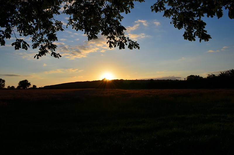
The images below were captured by myself on the evening of the summer solstice in 2015 as the sun descended behind the summit of Red hill which lies 3.5 kilometres NW of the site of St. Brigid's cathedral in Kildare town. It was once possible to observe this solstice sunset from the site of St. Brigid's, but today a view of the summit of Red hill is obscured by large trees and buildings close by. Red hill has a trivallate ring-barrow at its summit.
 0
0 -
HoteiMarkii wrote: »No one can give you a definitive answer as to what the site may have looked like in prehistory, but we do know that St. Brigid's was the site of an early Christian monastic settlement established circa 470 A.D. A model reconstruction of the early Christian settlement is on display in the visitor center in the cathedral, and although I don't have an image of that, it may have looked not unlike the illustration below:
Where the church in the above illustration is a stone built construct, it's likely the early church and buildings at St. Brigid's were all timber built.
An early Christian monk, Cogitosus, writing in the 7th Century A.D. alludes to the presence of a pagan fire temple on this site prior to the establishment of the monastic settlement. Some scholars have suggested it was a centre of pagan religious worship, a fire-cult dedicated to the goddess Brigid. The historian and archaeologist R.A.S. Macalister argued that Brigid was a leader of a coven of priestesses devoted to a pagan fire-cult at the site of a sacred oak who persuaded her charges to adopt the new religion of Christianity (source - Catherine Swift: Brigid, Patrick and the Kings of Kildare, A.D. 640-850; Kildare:History & Society).
That would explain the Fire Pit at the back of the cathedral.0


Advertisement