Advertisement
If you have a new account but are having problems posting or verifying your account, please email us on hello@boards.ie for help. Thanks :)
Hello all! Please ensure that you are posting a new thread or question in the appropriate forum. The Feedback forum is overwhelmed with questions that are having to be moved elsewhere. If you need help to verify your account contact hello@boards.ie

Interesting Maps

12467233

Comments

  • Banned (with Prison Access) Posts: 9,078 ✭✭✭IAMAMORON


    Sky King wrote: »
    It's highly suspect.

    Ours starts with Sinn which means 'us' or 'we' doesn't it?

    Doesn't start with fkin Soldiers anyway.

    In the English version of Amhrán Na Bhfhian there are some liberties taken on translation to enable the anthem to be sung smoothly.

    Sinn é Fianna Fáil

    Translates to

    Soldiers are we

    Yes it actually says We are soldiers, but try singing it that way as opposed to We are Soldiers. It doesn't have the same ring to it, thus the switch.

    It cuts both ways. The line

    "Anocht a théam sa Bhearna Bhaoil"

    gets a direct translation to

    Tonight we will man the "Bhearna Bhaoil"

    The literal translation of Bhearna Bhaoil is " the gap of danger" it is actually an area in the Wicklow Mountains somewhere around the glen of Imal and Lug na Quilla. Famous bandit area around 400 years ago, but that is a different story.

    In the Irish version the "Bhearna Bhaoil" is actually a symbol of bravery against future problems. It is about standing up to adversity and doing the right thing, kind of. Being brave for your country. Fighting for what is right against all odds etc.


  • Registered Users Posts: 5,412 ✭✭✭Charles Babbage


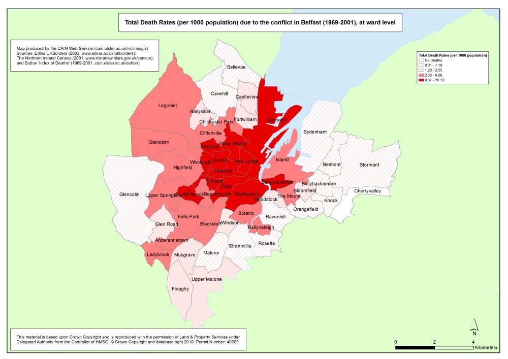
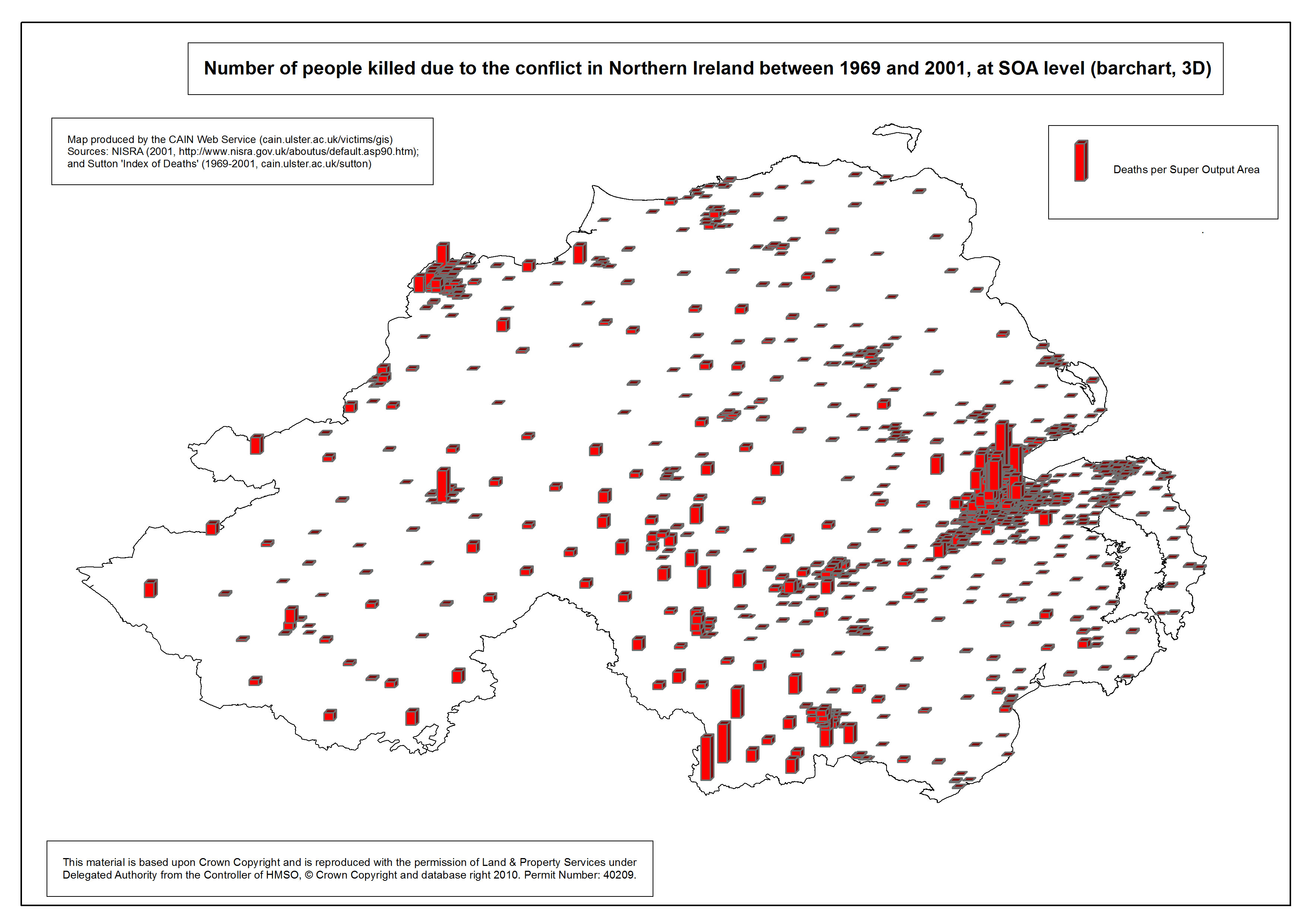
    i can't find it online but in Ed Moloney's book "Voices From the Grave" about a UVF man (David ervine) & about a IRA man (Brendan Hughes) it shows 3 different very detailed maps about The Trouble hot spots. Fiirst map is about the North of Ireland in it's entirety and shows all the the main places in it like Greysteel, Strabane, Sion Mills, Omagh, Crossmaglen, Camlough, Derry Claudy, Newry, Craigavon etc...the only places it shows outside the North are Belturbet, Monaghan town, Dundalk & Pettigo

    The second map shows Belfast, it shows all the main places in East, South, West & North. So South you have Andersontown & Castlreagh, in the North you have Ardoyne, Glengormley, Mount Vernon etc.... In the West you have the Truf Lodge, Falls, Ballymurphy, Shankill, Woodvale, Sandy Row, Shankill etc...And in the East you have the Short Strand, Newtownards, Woodstock, Ravenhill etc...

    And the final one is about the Falls Road circa 1969.
    So you have the Royal Victoria Hospital (not sure if it's there now), Roden street, Grosvenor road, Cyprus street, Lesson street, Little Distillery & places like Divis Flats, the Clonard Monastrey, Bombay street & so on, very interesting just to see clearly how close the UVF & IRA were pusehed up together with RUC & British soldiers in the mix as well, like a giant bomb ready to explode


    Lots of similar maps on the Cain website
    CAIN-Map_Belfast_Death-rates_Total.jpgCAIN-Map_NI_3D.jpg


  • Site Banned Posts: 135 ✭✭Sloppy_Joe


    Cut out the middleman and go to reddit.com/r/mapporn


  • Registered Users Posts: 10,301 ✭✭✭✭gerrybbadd


    Not sure has this been posted already

    od7kz1k46p241.jpg


  • Banned (with Prison Access) Posts: 9,078 ✭✭✭IAMAMORON


    I love the chlann map, but it is very controversial in fairness. I never understood why there were no similar chlann names around the country. Good map though, I have seen her before, but a pinch of salt required.


  • Advertisement
  • Registered Users Posts: 18,921 ✭✭✭✭BonnieSituation


    IAMAMORON wrote: »
    In the English version of Amhrán Na Bhfhian there are some liberties taken on translation to enable the anthem to be sung smoothly.

    Sinn é Fianna Fáil

    Translates to

    Soldiers are we

    Yes it actually says We are soldiers, but try singing it that way as opposed to We are Soldiers. It doesn't have the same ring to it, thus the switch.

    It cuts both ways. The line

    "Anocht a théam sa Bhearna Bhaoil"

    gets a direct translation to

    Tonight we will man the "Bhearna Bhaoil"

    The literal translation of Bhearna Bhaoil is " the gap of danger" it is actually an area in the Wicklow Mountains somewhere around the glen of Imal and Lug na Quilla. Famous bandit area around 400 years ago, but that is a different story.

    In the Irish version the "Bhearna Bhaoil" is actually a symbol of bravery against future problems. It is about standing up to adversity and doing the right thing, kind of. Being brave for your country. Fighting for what is right against all odds etc.

    To be more accurate, the Anthem was originally composed in English. The Irish version is the translation. so any "liberties taken" are there as Gaeilge.


  • Registered Users Posts: 8,810 ✭✭✭Hector Savage


    Sloppy_Joe wrote: »
    Cut out the middleman and go to reddit.com/r/mapporn

    Yeah but reddit is full of /dickheads ...


  • Closed Accounts Posts: 8,474 ✭✭✭Obvious Desperate Breakfasts


    KAGY wrote: »
    The map of Ireland before and after the Down Survey, the first large scale survey based on triangulation.

    My favourite thing about that that I always remember from history class is that it was called the Down Survey simply because it was written down.


  • Registered Users Posts: 1,089 ✭✭✭KAGY


    My favourite thing about that that I always remember from history class is that it was called the Down Survey simply because it was written down.

    I thought is was because they laid down chains (as in the actual standard chains made up of rods of the imperial measurement system).

    But your reason makes as much sense.

    BTW: wikipedia
    The chain is a unit of length equal to 66 feet (22 yards). It is subdivided into 100 links[1][2] or 4 rods. There are 10 chains in a furlong, and 80 chains in one statute mile.[2] In metric terms, it is 20.1168 m long.[2]


  • Posts: 0 [Deleted User]


    And a cricket pitch is one chain long (from the Bureau of Useless Factoids)


  • Advertisement
  • Registered Users Posts: 8,147 ✭✭✭Quantum Erasure


  • Registered Users Posts: 1,362 ✭✭✭dePeatrick


    Interactive map of migration to Europe. Worth watching from 2015 onwards to see why panic ensued and just how much it has been reduced since then.

    https://www.lucify.com/the-flow-towards-europe/

    I have no idea if or how to embed this...


  • Registered Users Posts: 9,167 ✭✭✭Fr_Dougal


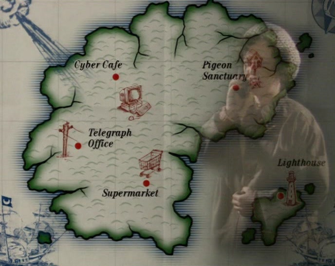
    Craggy Island.

    S03E07-VihZH77V.jpg


  • Moderators, Social & Fun Moderators Posts: 12,548 Mod ✭✭✭✭JupiterKid


    Great to see this thread, started by map lover yours truly, becoming a firm favourite of AHers and boardsies in general. :)

    I love to share my passion for maps. :P

    Anywho, here’s a few more to add to the thread:-


    The Ocean Floors of the World
    0714IL_PL_MAP_01-web.jpg


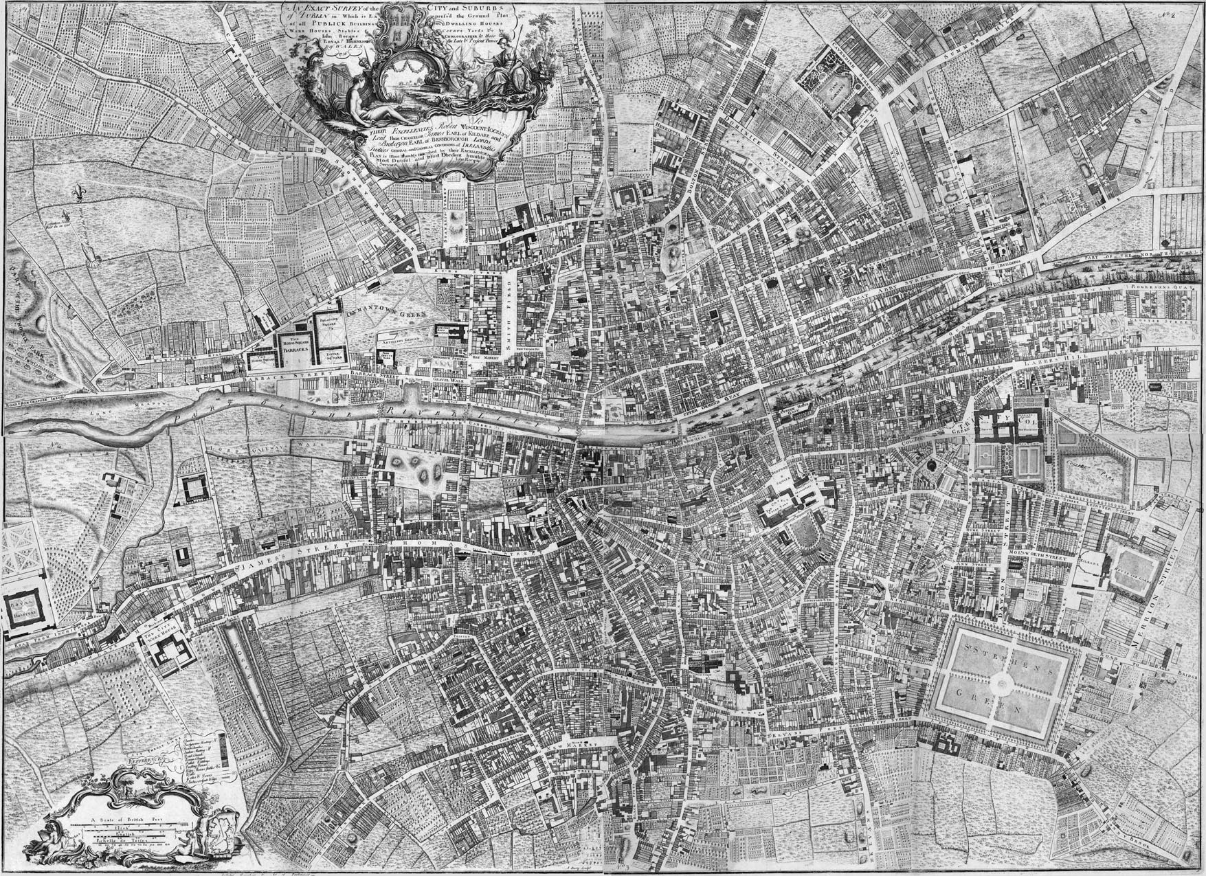
    John Rocque Map of Dublin, 1756
    map_5_rocque.jpg


    Concentration of LGBT Venues in London, 2006
    59609f19bb3503261c7f6fc7?width=1100&format=jpeg&auto=webp


  • Registered Users Posts: 4,814 ✭✭✭harry Bailey esq


    JupiterKid wrote: »
    I have had a huge interest in maps and geography since I was a very small child - I am generally fascinated with the way places and routes are related to each other in spatial terms, and I could pore over a good map for ages.

    So here’s a little thread on maps that I find interesting and fascinating - some represent data, some physical features, others may display key routeways and connectivity and others again might show urbanisation and the growth patterns of cities.

    Here’s one to start off....The number of army tanks per 10K population in Europe, by country. Feel free to post your own! :D

    11417_73900438_d30ebf39-dce8-4f29-828c-2f7ebe310c4d.jpeg
    I'm exactly the same kid.There's a good video on YouTube, name escapes me now but easy enough to find. It's all about enclaves and exclaves. There is a town on the Dutch/Belgian border that has a Belgian enclave, and within said enclave is a Dutch exclave and within the Dutch enclave thre happens to be a Belgian enclave! It's about the size Athlone this town. Image all the shady sj;t you could get away with there.


  • Posts: 7,712 ✭✭✭[Deleted User]


    I'm exactly the same kid.There's a good video on YouTube, name escapes me now but easy enough to find. It's all about enclaves and exclaves. There is a town on the Dutch/Belgian border that has a Belgian enclave, and within said enclave is a Dutch exclave and within the Dutch enclave thre happens to be a Belgian exclave! It's about the size Athlone this town. Image all the shady sj;t you could get away with there.

    Baarle. The map of it is class.

    https://en.m.wikipedia.org/wiki/Baarle


  • Registered Users Posts: 15,176 ✭✭✭✭ILoveYourVibes


    When I was a child my mother took me to an art exhibition .....and the exhibition was drawings of different maps from around the world.

    You really felt like you could feel the places they were of from looking at them.


  • Closed Accounts Posts: 8,492 ✭✭✭Sir Oxman


    Great, great thread.


  • Registered Users Posts: 916 ✭✭✭Jakey Rolling


    And a cricket pitch is one chain long (from the Bureau of Useless Factoids)

    An acre is 1 chain x 1 furlong
    ie. 22 x 220 yards = 4840 sq yards

    100412.2526@compuserve.com


  • Moderators, Politics Moderators Posts: 38,701 Mod ✭✭✭✭Seth Brundle


    Ptolemy's map of Hibernia c.140AD
    MI%20PTOLEMYS%20MAP%20OF%20IRELAND%20%20c%20140%20AD.jpg


  • Advertisement
  • Moderators, Politics Moderators Posts: 38,701 Mod ✭✭✭✭Seth Brundle


    I think anyone with an interest in maps should browse the various layers available through the OSI's mapviewer: http://map.geohive.ie/mapviewer.html
    Hours of fun :)


  • Moderators, Politics Moderators Posts: 38,701 Mod ✭✭✭✭Seth Brundle


    Speed's map of Dublin 1610

    01-speed-dublin-1610.jpg?itok=tc74LrO7&timestamp=1480941994


  • Moderators, Politics Moderators Posts: 38,701 Mod ✭✭✭✭Seth Brundle


    5371024.jpg


  • Moderators, Politics Moderators Posts: 38,701 Mod ✭✭✭✭Seth Brundle


    John Rocque map of Dublin 1762 (cen't find the full image to embed here but it's worth viewing)
    https://iiif.lib.harvard.edu/manifests/view/ids:10135315


  • Registered Users Posts: 2,791 ✭✭✭BionicRasher


    love this site http://digital.ucd.ie/maps/explorer/

    hours of fun digging around places you know

    example - Cobh 1866
    https://digital.ucd.ie/view-media/ucdlib:40600/canvas/ucdlib:41969


  • Registered Users Posts: 11,193 ✭✭✭✭Father Hernandez


    Following, excellent thread.

    Some below:

    European Legal Drinking Age
    DrinkingAgeEurope.gif

    World Air travel routes
    interesting-map9.jpg

    GDP of state v other countries
    interesting-map32-940x576.png


  • Posts: 0 [Deleted User]


    An acre is 1 chain x 1 furlong
    ie. 22 x 220 yards = 4840 sq yards

    You can become an honorary member of the Bureau of Useless Factoids if you’d like. :D


  • Banned (with Prison Access) Posts: 9,078 ✭✭✭IAMAMORON


    John Rocque map of Dublin 1762 (cen't find the full image to embed here but it's worth viewing)
    https://iiif.lib.harvard.edu/manifests/view/ids:10135315

    O'Connell ( Sackville ) Bridge was not built for another 30 years. It is crazy seeing the city like that. No Canals.


  • Moderators, Politics Moderators Posts: 38,701 Mod ✭✭✭✭Seth Brundle


    IAMAMORON wrote: »
    O'Connell ( Sackville ) Bridge was not built for another 30 years. It is crazy seeing the city like that. No Canals.
    Fairview hasn't been filled in yet. The Tolka went under a different name (Ballybough Riveer).
    Trinners was a bit smaller and more rural.
    Merrion Square is in the countryside.
    Baggott St. was called Gallows Rd. Leeson St was the Road to Donnybrook.
    There's no brewery aliong the quays.


  • Advertisement
  • Registered Users Posts: 5,942 ✭✭✭topper75


    IAMAMORON wrote: »
    O'Connell ( Sackville ) Bridge was not built for another 30 years. It is crazy seeing the city like that. No Canals.

    South wall is older than O'Connell bridge! You learn something new every day.
    I'm not a Dub but I'll bet you most Dubs would not know this.
    Why don't RTÉ commission some Irish urban history docu stuff if they claim to be a PS broadcaster? Relatively cheap to make and endless source material.
    Éamonn MacThomáis's stuff is decades ago.


Advertisement