Advertisement
If you have a new account but are having problems posting or verifying your account, please email us on hello@boards.ie for help. Thanks :)
Hello all! Please ensure that you are posting a new thread or question in the appropriate forum. The Feedback forum is overwhelmed with questions that are having to be moved elsewhere. If you need help to verify your account contact hello@boards.ie
Hi all,
Vanilla are planning an update to the site on April 24th (next Wednesday). It is a major PHP8 update which is expected to boost performance across the site. The site will be down from 7pm and it is expected to take about an hour to complete. We appreciate your patience during the update.
Thanks all.

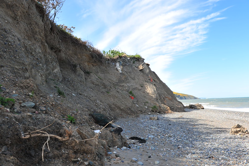
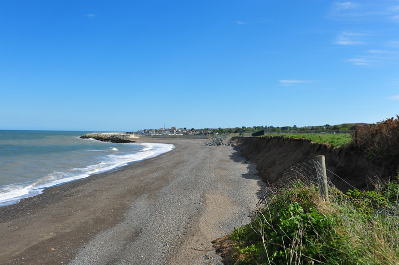
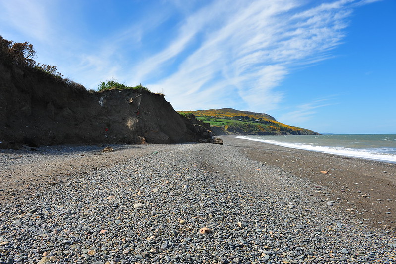
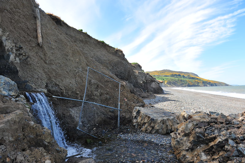
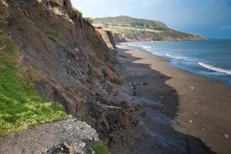
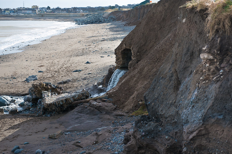
Erosion of north Wicklow coast. Possible cause: Greystones Harbour Development?

1235789

Comments

  • Registered Users Posts: 6,250 ✭✭✭pixbyjohn


  • Registered Users Posts: 6,250 ✭✭✭pixbyjohn


  • Registered Users Posts: 6,250 ✭✭✭pixbyjohn


  • Registered Users Posts: 592 ✭✭✭Cheeky Chops


    Careful John. We don't want to find you buried under a landslide with the tide rapidly approaching. :P

    In all seriousness it looks like a war zone down there. It's outrageous and the lack of accountability is shameful. The lack of solution is soul destroying.

    CC


  • Registered Users Posts: 6,250 ✭✭✭pixbyjohn


  • Advertisement
  • Registered Users Posts: 6,250 ✭✭✭pixbyjohn


  • Registered Users Posts: 5,616 ✭✭✭Charlie-Bravo


    wow...thanks for those John. It certainly doesn't look safe either. These are worth forwarding to the Parks department of the Council as it is a safety risk.

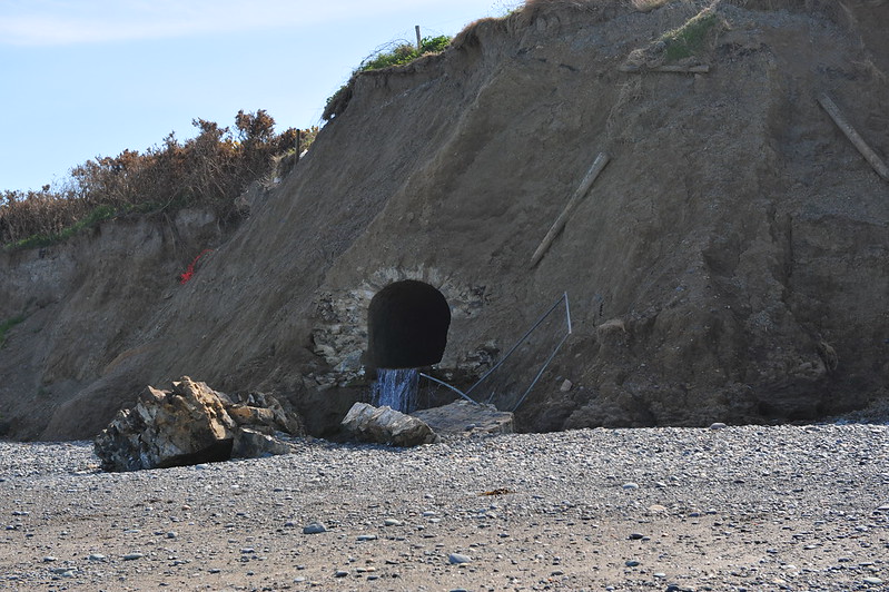
    Where does the tunnel begin?

    -. . ...- . .-. / --. --- -. -. .- / --. .. ...- . / -.-- --- ..- / ..- .--.


  • Registered Users Posts: 6,250 ✭✭✭pixbyjohn


    Hi Astro, thank you.
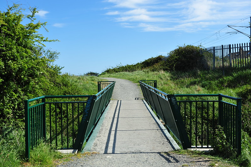
    This is where that stream runs under this footbridge further inland.
    8806508337_3c89d08e9b_c.jpg
    Cliff Walk Path, Greystones by pixbyjohn, on Flickr


  • Registered Users Posts: 5,616 ✭✭✭Charlie-Bravo


    ah I recognise it....did a mountain bike ride up around cliff walk last week (forgot about the steps part when I began). I don;t venture up that way much but will bring camera with me next time.

    -. . ...- . .-. / --. --- -. -. .- / --. .. ...- . / -.-- --- ..- / ..- .--.


  • Registered Users Posts: 6,250 ✭✭✭pixbyjohn


  • Advertisement
  • Registered Users Posts: 6,250 ✭✭✭pixbyjohn


  • Banned (with Prison Access) Posts: 81 ✭✭gibbon6


    The level of coastal erosion here is terrible. Sisks will have to move their green fencing back again before it falls into the sea. It sickens me that as part of the planning approval from An Bord Pleanala Sisks were supposed to place beach nourishment material on the north beach but have only placed a tiny fraction of the contractual requirement on it. Sisk’s made a unilateral decision to value engineer their capital and contingent liability [without agreement from the stakeholders], which has already saved them over €850,000. Wicklow County Council are supposed to be monitoring compliance by Sisks of the planning conditions but do nothing. Cllrs Mitchell and McLaughlin have been made fully aware of this but they also have done absolutely nothing about it. Indeed they do all they can to protect Sisks. This is a scandal of the highest order.


  • Registered Users Posts: 800 ✭✭✭Jimjay


    pixbyjohn wrote: »

    Is tha pile of rocks in the background the 'beach nourishment' or are they from erosion?


  • Banned (with Prison Access) Posts: 81 ✭✭gibbon6


    Jimjay wrote: »
    Is tha pile of rocks in the background the 'beach nourishment' or are they from erosion?

    That's the rock revetment that's supposed to protect the old town dump. However, there are already signs that the dump is now starting to erode onto the beach.


  • Registered Users Posts: 14,713 ✭✭✭✭loyatemu


    speaking of beach nourishment - a huge amount of sand has washed up on the South Beach during the recent storms - the beach now stretches around the rocks in front of David's and the diving board is more-or-less covered in sand. The Cove in contrast has had all its pebbles washed out and the ramp is now about a metre above the level of the sand.

    If SISK did nourish the North Beach, what would be the effect on erosion elsewhere along the coast (genuine question, was this addressed in the planning permission when they were told to supply beach nourishment)? The increased erosion at the North Beach has come in the wake of a) the building of the harbour b) the placing of rock armour around Bray Head by Irish Rail. Its now the soft filling between 2 well-protected sections of coastline.


  • Registered Users Posts: 800 ✭✭✭Jimjay


    loyatemu wrote: »
    speaking of beach nourishment - a huge amount of sand has washed up on the South Beach during the recent storms - the beach now stretches around the rocks in front of David's and the diving board is more-or-less covered in sand. The Cove in contrast has had all its pebbles washed out and the ramp is now about a metre above the level of the sand.

    If SISK did nourish the North Beach, what would be the effect on erosion elsewhere along the coast (genuine question, was this addressed in the planning permission when they were told to supply beach nourishment)? The increased erosion at the North Beach has come in the wake of a) the building of the harbour b) the placing of rock armour around Bray Head by Irish Rail. Its now the soft filling between 2 well-protected sections of coastline.

    The south beach was the same after last years storms and then cleared itself out over a short period of time.


  • Registered Users Posts: 594 ✭✭✭Fiachra2


    The issue was indeed "considered" but the solution was rather dubious

    It was acknowledged by WCC that the harbour would accelerate erosion immediately to the North. Therefore it was decided to deposit material on the beach to nourish it. It was accepted that this material would be washed away (to where was unknown)in time and so it was to be replaced by further material. This material was to come from a Quarry in Wicklow. Its worth considering the environmental "logic" behind this.
    A man made structure created erosion so the solution is to, in effect, dig up the Wicklow mountains in perpetuity and dump them on the beach to be washed away to sea.

    What is of course more important is that as we see from the photos the process isn't working. This is because Sisk have unilaterally abandoned the requirements of the planning permission. They have ceased to deposit the required quantities of material on the beach in breach of the planning permission. Not surprisingly WCC has done nothing.

    So in answer to the question the beach north of the harbour -and subsequently the cliffs-will wash away to sea.


  • Registered Users Posts: 800 ✭✭✭Jimjay


    Fiachra2 wrote: »
    The issue was indeed "considered" but the solution was rather dubious

    It was acknowledged by WCC that the harbour would accelerate erosion immediately to the North. Therefore it was decided to deposit material on the beach to nourish it. It was accepted that this material would be washed away (to where was unknown)in time and so it was to be replaced by further material. This material was to come from a Quarry in Wicklow. Its worth considering the environmental "logic" behind this.
    A man made structure created erosion so the solution is to, in effect, dig up the Wicklow mountains in perpetuity and dump them on the beach to be washed away to sea.

    What is of course more important is that as we see from the photos the process isn't working. This is because Sisk have unilaterally abandoned the requirements of the planning permission. They have ceased to deposit the required quantities of material on the beach in breach of the planning permission. Not surprisingly WCC has done nothing.

    So in answer to the question the beach north of the harbour -and subsequently the cliffs-will wash away to sea.

    If this is in fact a breach of planning permission then are there not legal paths that can be taken? or can this be petitioned to be discussed in government?
    Has anyone considered taking legal action?


  • Registered Users Posts: 6,250 ✭✭✭pixbyjohn


    Jimjay wrote: »
    If this is in fact a breach of planning permission then are there not legal paths that can be taken? or can this be petitioned to be discussed in government?
    Has anyone considered taking legal action?

    NO


  • Banned (with Prison Access) Posts: 81 ✭✭gibbon6


    Set out below was evidence given by Professor Andrew Cooper to An Bord Pleanala in March 2007 when he warned of the impact of the development on coastal erosion on the North Beach!

    An Bord Pleanála Oral Hearing of Appeals against the Application by Wicklow County Council for Approval of a Public-Private Partnership Development at Greystones Harbour and North Beach, Rathdown Upper and Rathdown Lower, Greystones, County Wicklow
    An Bord Pleanála Reference 27.EF 2016

    Oral Hearing, Bray, 29 and 30 March 2007
    ____________________________________________

    STATEMENT OF EVIDENCE
    by Prof. J. Andrew G. Cooper, BSc, MSc, PhD

    ON BEHALF OF THE GREYSTONES PROTECTION AND DEVELOPMENT ASSOCIATION

    1. Qualifications and Experience

    I graduated in 1984 from Queen’s University Belfast in geology, and I was initially employed in southern Scotland on a geological reconnaissance project with BP Minerals. I moved to South Africa in 1985 where I worked for two years in the University of Natal on sedimentation in estuaries and a further seven in the CSIR on coastal processes. I gained my MSc and PhD from the University of Natal in 1987 and 1991, respectively. I took up a senior lectureship at the University of Greenwich, UK in 1993 and a Readership at the University of Ulster in 1994. I was appointed to a personal chair in coastal studies in 2004. I have published more than 200 papers in the field of coastal processes and coastal management and have worked on a variety of research projects in the UK, Ireland, the EU and around the world.

    2. Introduction

    My evidence today is on behalf of the Greystones Protection and Development Association, and arises from the Association’s concern about the applicant’s proposal for beach nourishment to mitigate the impacts of its proposed marina development at Greystones Harbour.

    In my evidence I will address the question of the mechanism of delivery of beach recharge material to the site, the volume thereof and the long term implications of this approach.

    My evidence will have particular regard to the question raised by the Board in its letter dated 14 August 2006 to Wicklow County Council. In that letter, the Board stated

    “Noting the already restricted road access to the site, the Board is not satisfied on the basis of the submissions made that the required beach nourishment of approximately 6,000 tonnes per annum cannot be brought to site by sea in order to mitigate any potential negative traffic impacts resulting from the proposal to bring this material by road, and consequently through the future completed development”.

    3. The Applicant’s Proposal for Beach Nourishment

    The applicant considers, on the basis of numerical modelling of coastal processes, that accelerated coastal erosion is likely to result from the proposed development. It has been proposed that this be addressed by rock armouring of the seaward edge of the old dump site and beach nourishment in the area north of this for a period of 30 years. The recharge material is to be sourced from gravel quarries on land and transported by lorry to the beach at a rate of 6000 m3 per year, following an initial emplacement of 30,000 m3. Calculation of these required sediment volumes relies on future predictions of shoreline behaviour under various scenarios. Because the volume of material being transported to the beach is the subject of the board’s letter of August 14th to the developer, I would therefore like to look briefly at the means by which these required volumes are derived.

    3.1. Beach behaviour: actual and predicted

    Beaches are loose accumulations of sand and/or gravel that can adapt their shape to variations in wave, tide and wind conditions, sediment supply (volume of available material) and sediment type (size, shape and composition). They do so within a fixed geological framework. They may be bounded by headlands or underlain or backed by rock of variable resistance to erosion. The beach adjusts to the combined effect of these parameters at any given time and hence achieves a dynamic equilibrium. A change in any one of these factors may produce a change in the beach itself.

    Construction of the marina changes the framework within which the beach exists. This changes the physical boundaries within which the beach exists, which in turn alters the wave dynamics. This adjustment in two of the major controls on beach shape and position will produce a change in the beach shape. There is no accurate way of modelling the likely future shape of the beach under such conditions .

    The models (part of the DHI Litpack suite) that were used by the applicant (Greystones Harbour EIS Appendix 6) to predict shoreline evolution for different marina scenarios are complex numerical models that aim to make various predictions regarding, coastal hydraulics, volumes of longshore sediment transport, and future shoreline positions under various scenarios. In order to make accurate predictions of future shoreline positions and sediment transport rates, such models must take account of all the variables that impact on sediment transport .

    There are several reasons, however, that mean that such models cannot produce accurate simulations. They include the following:
    • Certain important parameters to be omitted from calculations (e.g. packing and density of sediment);
    • Not all important model parameters and their interactions are understood. Scientific understanding of transport of mixed grain populations is very limited ;
    • There is a ubiquitous inability to accurately characterise the starting conditions (grain size, wave conditions, precise beach shape, underlying rock depth, resistance to erosion etc); For example, the Greystones beach is described in the developer’s reply to the board’s leter of August 14th 2006, simply as “shingle with a median size of 5mm”. This gives no indication of the range and proportions of grain sizes and shapes.
    • Some questionable relationships are used in models (e.g. relationship between wave angle and longshore drift rate);
    • Constants are frequently used to adjust model outputs to achieve ‘reasonable’ predictions. For example, a range of wave theories can be selected as well as bed roughness parameters and wind or currents can be omitted or included as the operator chooses- this enables the operator to adjust the model result to match a target value;
    • The unpredictability of future wave, tide and weather conditions.
    • The role of extreme but infrequent storms, that may strongly influence or even dominate shoreline behaviour cannot be predicted or simulated. These may produce much more change in a few days than decades of ‘normal conditions’. At Kilpatrick beach in northern Wexford, for example, storms in early December 2006 caused more than 10m of erosion on a beach and dune that had been essentially stable for the previous decade;

    Using the models produces a single quantitative prediction without giving any indication of the probability of such a scenario actually occurring. One can have little confidence in such a simulation and in the case of Greystones, the predicted impact of the marina derived by modelling is therefore quite uncertain. As a consequence, the volume of material required to ‘remedy’ the situation cannot not known. The volumes cited (6000m3 per year and an initial capital emplacement of 30,000 m3 may be much too low or much too high. Raising the amount from 4000m3 to 6000m3 as has been done in the EIS to ‘ account for the inaccuracy of the 1-D model) has no basis in reality, as the model has no error bands.

    3.2. Required volume of nourished sand

    The practice of placing sediment on an eroding beach to replace or augment natural sediment supply is now widespread practice in many heavily developed coastal areas. Because of the complexity of interactions outlined above, it is not possible to accurately predict future beach nourishment requirements or longevity of nourished beaches. Models are commonly used to make such predictions but they suffer from several fatal shortcomings.

    The inability to predict performance of beaches using models relates to several factors. One is the inability to describe the grain size; Beaches contain a range of different grain sizes distributed throughout the beach). Another is the inability to describe the wave conditions; Natural seas are affected by a range of wave sizes that interact with each other, with the wind and with any currents to produce complex fluid motions that vary over time. The role of storms is particularly poorly understood. A third is the chaotic behaviour of the weather that produces waves and currents.

    Studies have shown that nourished beaches almost always last for a shorter time than that predicted. Usually, the poor performance is explained by an unexpected storm and there have been several instances when entire nourished beaches have been eroded within a few days. The inaccuracy of models is certainly a contributing factor to poor performance, but the overwhelming dominance of over-predicting the longevity of nourished beaches shows an ill-placed optimism in many such exercises.

    The potential situation whereby nourished material is washed away rapidly by a storm is not considered in the developer’s report.

    As a result of sea level rise and climate change resulting in the likely increased incidence of storms in the Irish Sea, the volume of material required to maintain the beach position will not remain constant but an ever greater volume of material will be required in the future. There is no commitment to providing a greater volume than that laid out in the developer’s proposal. Furthermore, any increase in volume would increase the traffic volume and level of disturbance on the beach.

    3.3. Suitability of proposed fill material

    The beach at Greystones derives its sediment from the eroding cliffs of fluvio-glacial sediment at the rear of the beach. This material has been initially sorted by ancient, glacial-related processes and when it is eroded by modern waves it undergoes further sorting on the beach. This produces a distinctive distribution of sediment according to grain size and shape on the beach. A particular packing arrangement is achieved whereby the grains fit together in a particular way. Using material from a different source (an inland quarry) and depositing it directly on the beach by a different mechanism (dumping from a lorry) produces a different packing arrangement and will cause the beach to respond differently to wave processes. Nourished beaches are usually found to erode more rapidly than their natural predecessors.

    In addition, no quantitative analysis of the textural characteristics of the proposed source material and the natural beach source material has been undertaken to determine the differences. The high incidence of broken stones in the Ballyhorsey quarry material and its angular nature contrasts markedly with the smoothed and rounded nature of the present beach material. The possibility of use of offshore marine sediments is considered in the developer’s reply but is subject to many uncertainities. The land-sourcing and transport of nourishment material seems to be favoured.

    3.4. Environmental value of nourished beach

    Beach nourishment involves a high level of vehicular and mechanical activity around and on the beach. This disturbance will have adverse impacts on plant and animal life on the beach. Upper beach vegetation will be disturbed by the movement of imported material across and on the beach. The beach infauna will be buried and the different styles of packing and probability of fine interstitial grains may affect biological colonisation and use of the beach surface. It is unlikely to be packed and sorted by mechanical emplacement in the same way as it would be by waves and this may impact on the recreational value of the beach.

    3.5. Sustainability of nourished beach

    Above all, it is important to note that the beach nourishment is being proposed as an antidote to problems that will arise through construction of the proposed marina. It is an acknowledgement that an undesirable impact will be created and is a proposed mechanism to reduce this impact. The nourishment is proposed to continue to be financed and undertaken for thirty years by the marina operating company. At the end of thirty years, however, when the nourishment stops, the adverse impacts of the marina will still remain. The resulting problem or accelerated erosion, even if the nourishment performs as the developers expect, is therefore not mitigated but simply forestalled or postponed. The question of who will take responsibility for the adverse impacts on the coast at that time remains unresolved. It would seem unreasonable for the public to take over such responsibility since the impact is the result of private development. If not, how would the adverse impacts be managed at that time?

    Once humans interfere with a shoreline, there is usually no going back. The first intervention typically produces undesirable impacts which require additional interventions to ’remedy’ them. They in turn produce further impacts and the beach is transformed from a natural system to an increasingly human-influenced system, dependant on political decisions and economics for its survival. The artificially nourished beaches of southern Spain, backed by sea walls and defended by offshore breakwaters are ultimate expression of this urbanisation of beaches. There, the high volume of beach-dependant tourism activity provides an economic driver to sustain beach nourishment. No such driver exists at Greystones.

    Nourishing a beach creates an artificial condition and a commitment to sustain that beach for ever. This is a major commitment for this and future generations to enter into, in order to resist changes that are the result of a one-off marina development.

    4. Conclusions

    On behalf of the Greystones Protection and Development Association we suggest to An Bord Pleanála that this development will have unpredictable and unquantifiable impacts on a natural beach system. The proposed mitigation by beach nourishment will have negative impacts on the natural environment and the local infrastructure. The volume of material required to maintain a given beach position cannot be known and any increase in volume required would have additional environmental impacts. Most importantly, the practice is not sustainable. The development will create a permanent environmental problem that will persist (and most probably be excerbated) beyond the thirty year lifespan of the proposed interventions.

    Andrew Cooper


  • Advertisement
  • Registered Users Posts: 138 ✭✭Wicklow Will


    Something most definitely needs to be done. WCC have provision for it in the new Local Area Development Plan!

    The late Maureen Willis and residents in The Grove had a petition going in 2012, on this matter I seem to recall. Wonder whatever became if it?


  • Registered Users Posts: 304 ✭✭F3


    stop panicing, Derek Mitchell, George Jones and Granne McLaoughlin say is perfectly OK, its supposed to be like that........


  • Banned (with Prison Access) Posts: 81 ✭✭gibbon6


    F3 wrote: »
    stop panicing, Derek Mitchell, George Jones and Granne McLaoughlin say is perfectly OK, its supposed to be like that........

    The Fine Gael/Fianna Fail councillors in Greystones ignored the wishes of the people of Greystones in their usual contemptuous way and ensured that Sisks/Wicklow County Council were gifted the harbour and North Beach. George Jones and his Fine Gael councillors are still literally giving the 2 fingers to the Greystones population by supporting Sisks rather than the Community Plan. The only good thing is that he is retiring in May - 5 years too late.


  • Registered Users Posts: 473 ✭✭BigGeorge


    We dont need brave photographers when we have intrepid locals willing to go read the EIS commitments made by WCC/ Sispar & video site progress. The only progress being made on this project is by the sea.....& they are doing a great job by all accounts

    See for yourselves what our Town Councillors have decided is acceptable on our behalf & decide for yourselves :

    https://www.youtube.com/watch?v=BFIiNN8Rl9A


  • Registered Users Posts: 1,516 ✭✭✭Maudi


    Zoo4m8 wrote: »
    Absolutely!......:p. Now, back to harbour topics...

    Just looking at some local footage on u-tube of darcys field aka the old town dump being eroded away..an environmental disaster occuring before our very eyes..a hugh length of sisks new foothpath /chainlink fence/drain pipes already gone in to the sea..in my humble opinion the long north wall of the harbour is forcing the incoming waves northward to darcys field /cliffs and in two or three years the erosion will eat in behind the actual harbour itself...some very urgent "grown up "decisions by competent people need to be made about this issue ..its not gona go away..apart from the sea eroding away at the bottom of the cliffs the severe downfalls of rain are leaving the north beach cliffs top heavy resulting in faster erosion..


  • Registered Users Posts: 304 ✭✭F3


    BigGeorge wrote: »
    We dont need brave photographers when we have intrepid locals willing to go read the EIS commitments made by WCC/ Sispar & video site progress. The only progress being made on this project is by the sea.....& they are doing a great job by all accounts

    See for yourselves what our Town Councillors have decided is acceptable on our behalf & decide for yourselves :

    https://www.youtube.com/watch?v=BFIiNN8Rl9A

    THIS IS HORRENDOUS !!!! :eek:


  • Registered Users Posts: 304 ✭✭F3


    It was a specific condition of the foreshore licence

    It was a condition of planning

    It was in the Environmental Protection Plan

    It was warned by the Department of the Marine that it was a significant commitment by Sisk and Wicklow County Council.

    There were to place 30,000 cubic metres of shingle knows as 'capital' when the break water was complete. This was a huge Dyke. It would have cost €750,000.

    This was not done. They placed 10,000 cubic metres for €250,000

    A saving of €500,000

    They were then to add what ever it takes to ensure that the historical rate of retreat was not increased. I see on the video this was upto 6000 cubic metres every year or €150,000

    This has not been done for 4 years, a saving of €600,000

    What they did do was move 6000 cubic metres ( so they say) of shingle that had built up naturally at the new cove. But guess what, THEY ARE EXPRESSLY PROHIBITED FROM DOING JUST THAT.

    This is about money money money money.

    By not doing what they are required to do, they have saved in hard cash

    €1,100,000

    Wicklow County Councillors have allowed them to do this despite the greystones people begging begging begging the local Councillors to do something about it.

    Who has the money?

    Why can they not be brought to justice for this horrendous rape to our natural environment caused by their breakwater structure? They surely have breached every rule in the book.


  • Registered Users Posts: 473 ✭✭BigGeorge


    I just don't understand.............Why does it look like the vast majority of TCs choose to cut Sisk so much slack & fail to hold Sisk to account when you have the power & opportunity?


  • Registered Users Posts: 970 ✭✭✭cuddlycavies


    BigGeorge wrote: »
    I just don't understand.............Why does it look like the vast majority of TCs choose to cut Sisk so much slack & fail to hold Sisk to account when you have the power & opportunity?
    Builders have never really been held to account for the damage they cause to environment, roads, etc in Ireland. There is a cosy relationship between huge contractors and government. No doubt about that at all! I would expect that the party aligned councillors of Greystones are taking ''Guidance'' from above!


  • Advertisement
  • Registered Users Posts: 304 ✭✭F3


    Is it the money?


Advertisement