2021 Atlantic/Pacific Hurricane Season
-
23-05-2021 9:13pm#1Tropical Storm Ana, the first of the 2021 Atlantic season, formed yesterday from a non-tropical low pressure system that was meandering northeast of Bermuda during the week. It started off as a weak subtropical storm and only reached a max windspeed of 40 knots before starting to die off in the latest outlook.
The 2021 season has a 60% probability of being above average, with 13-20 Named Systems, 6-10 hurricanes and 3-5 Major Hurricanes forecast in the NHC's latest forecast. One key factor is the transition to La Nina conditions and warmer seas in the southern North Atlantic and Caribbean.
The NHC have now moved to a new climate reference period of 1991-2020, which has meant an increase of 1 in Named Storms and Hurricanes (12 -> 13 and 6 -> 7, respectively). The number of Major Hurricanes has not increased.
Reasons for the increase in numbers are better detection, the positive AMO and possibly the warming climate (see below).Beginning with this year’s hurricane season outlooks, NOAA’s Climate Prediction Center (CPC) will use 1991-2020 as the new 30-year period of record. The updated averages for the Atlantic hurricane season have increased with 14 named storms and 7 hurricanes. The average for major hurricanes (Category 3, 4 or 5) remains unchanged at 3. The previous Atlantic storm averages, based on the period from 1981 to 2010, were 12 named storms, 6 hurricanes, and 3 major hurricanes.
NOAA is updating the set of statistics used to determine when hurricane seasons are above-, near-, or below-average relative to the climate record. This update process occurs once every decade.
“This update allows our meteorologists to make forecasts for the hurricane season with the most relevant climate statistics taken into consideration,” said Michael Farrar, director of NOAA’s National Centers for Environmental Prediction. “Our work illustrates the value of NOAA’s investments in next-generation technologies to capture the data that underpins our outlooks and other forecast products. These products are essential to providing the public and local emergency managers with advance information to prepare for storms, and achieving NOAA’s mission of protecting life and property.”
The increase in the averages may be attributed to the overall improvement in observing platforms, including NOAA’s fleet of next-generation environmental satellites and continued hurricane reconnaissance. It may also be due to the warming ocean and atmosphere which are influenced by climate change. The update also reflects a very busy period over the last 30 years, which includes many years of a positive Atlantic Multi-decadal Oscillation, which can increase Atlantic hurricane activity.
“These updated averages better reflect our collective experience of the past 10 years, which included some very active hurricane seasons,” said Matt Rosencrans, seasonal hurricane forecaster at NOAA’s Climate Prediction Center. “NOAA scientists have evaluated the impacts of climate change on tropical cyclones and determined that it can influence storm intensity. Further research is needed to better understand and attribute the impacts of anthropogenic forcings and natural variability on tropical storm activity.”
For the Eastern Pacific and Central Pacific basins the averages over the 1991 - 2020 period do not change. The Eastern Pacific basin will remain at 15 named storms, 8 hurricanes, and 4 major hurricanes. The Central Pacific basin will maintain an average of 4 named storms, 3 hurricanes and 2 major hurricanes.
NOAA will issue its initial seasonal outlook for the 2021 hurricane season in late May. The Atlantic hurricane season officially runs from June 1 through November 30. 3
3
Comments
-
2021 Atlantic names
Ana
Bill
Claudette
Danny
Elsa
Fred
Grace
Henri
Ida
Julian
Kate
Larry
Mindy
Nicholas
Odette
Peter
Rose
Sam
Teresa
Victor
Wanda0 -
Anyone who tracked last year's season lived through a truly historic event, as along with 2005, 2020 will be remembered as one of the only two seasons in which the Greek Alphabet was used in place of names once the season broke the named storms record and exhausted the list. They've decided from now on to use an emergency "supplementary names list", owing to the difficulty in retiring permanently the names of alphabet letters (impossible to replace) and the fact that several of the Greek alphabet named storms in 2020 were devastating to the point of meriting retirement for future seasons.
It's funny knowing that this will never happen again. It was an interesting moment for mets to hear that the Greek Alphabet was about to be used for only the second time ever, takes on a new kind of significance knowing that it's never going to happen again.
Seems unlikely that 2021 will match anything like the ridiculous heights of 2020 or 2005 in my view, the atmospheric setup doesn't seem to be there this year. Both seasons were characterised by extremely long "standing wave" periods in the Pacific and Indian Oceans, with subdued and enhanced convection respectively, partly due to the very early formation of the La Nina event which usually doesn't develop until later in the year, as well as the unusual pattern for this owing to the "modoki" nature of the preceding El Nino, which again in recent memory has only occurred in 2004 and 2019.
Probably far too early to be making such predictions, but none of the seasonal models is showing the kind of hyperactive enhancement-suppression pattern for July onwards in the same locations as last year.0 -
Several of last year's 30 named systems wouldn't have been detected or named in earlier years. The season was notable for the high number of very weak systems, with only 13/6 hurricanes/major hurricanes resulting. Average ACE was well down in the bottom quarter of all years on record.
I would argue that with improved detection and continuing questionable classification of some weaker systems we will see more years using the Greek alfabet, especially as there are only 21 names on the list. But this may not happen for a few more decades until we come back into an increasing AMO index, like back in the late '90s/early '00s0 -
Will the volcano in Congo have an effect on storm formation over the coming months?0
-
Gaoth Laidir wrote: »Several of last year's 30 named systems wouldn't have been detected or named in earlier years. The season was notable for the high number of very weak systems, with only 13/6 hurricanes/major hurricanes resulting. Average ACE was well down in the bottom quarter of all years on record.
I would argue that with improved detection and continuing questionable classification of some weaker systems we will see more years using the Greek alfabet, especially as there are only 21 names on the list. But this may not happen for a few more decades until we come back into an increasing AMO index, like back in the late '90s/early '00s
Are we just switching between average ACE and total ACE whenever it suits us now?0 -
Advertisement
-
-
Tropical Depression Two has formed from a non-tropical low off the coast of North Carolina. Currently 30 knots, it may become a tropical storm later tonight before dissipating over Nova Scotia in a couple of days' time.
Meanwhile, a disturbance in the Bay of Campeche could become better organised during the week as it slowly heads northwards. Also, there is a system coming off the coast of Africa but chances of development are very low due to dry air.Tropical Weather Outlook
NWS National Hurricane Center Miami FL
800 AM EDT Mon Jun 14 2021
For the North Atlantic...Caribbean Sea and the Gulf of Mexico:
1. Satellite, radar and surface observations indicate that a
well-defined low pressure system located about 90 miles southeast of
Cape Hatteras, North Carolina, is acquiring more tropical
characteristics. Environmental conditions appear conducive for
further development, and a tropical depression or tropical storm is
likely to form later today or tonight. This system is expected to
move northeastward away from the United States and move over colder
waters south of Nova Scotia on Wednesday, ending any opportunity for
further development by midweek.
* Formation chance through 48 hours...high...70 percent.
* Formation chance through 5 days...high...70 percent.
2. Showers and thunderstorms located over the Bay of Campeche are
associated with a broad low pressure area. Gradual development of
this disturbance is possible during the next couple of days while
it meanders near the coast of Mexico, and a tropical depression
could form late in the week when the system moves northward into
the central Gulf of Mexico. Regardless of development, heavy
rainfall is possible over portions of Central America and southern
Mexico during the next several days. Please consult products from
your local meteorological service for more information.
* Formation chance through 48 hours...low...20 percent.
* Formation chance through 5 days...medium...60 percent.
3. A strong tropical wave just offshore of west Africa is producing
disorganized shower and thunderstorm activity. Some development
of this system is possible during the next few days before a
combination of dry air aloft and strong upper-level winds limit any
chance of formation while the wave is over the central tropical
Atlantic Ocean late week.
* Formation chance through 48 hours...low...10 percent.
* Formation chance through 5 days...low...20 percent.
$$
Forecaster Blake 0
0 -
A very weak and hybrid Tropical Storm Claudette formed just offshore New Orleans earlier today and is now well inland. It may regerate as it enters the Alantic in a couple of days before becoming extratropical and dissipating.Tropical Storm Claudette Discussion Number 7
NWS National Hurricane Center Miami FL AL032021
400 AM CDT Sat Jun 19 2021
The system that we have been tracking for a few days finally has
enough of a well-defined center and organized convection to be
considered a tropical storm. While the organization is not
classical by any means, and there are some hybrid characteristics,
the cyclone most resembles a sheared tropical storm, so the system
is now Tropical Storm Claudette. The initial wind speed remains 40
kt, in line with surface observations and radar. These winds are
primarily occurring in a strong band on the eastern side of the
cyclone well away from the center.
Claudette is moving north-northeastward at about 10 kt. The storm
should turn northeastward and east-northeastward over the next day
or so while it moves around the northern side of the subtropical
ridge and gradually weakens to a depression/post-tropical cyclone.
The biggest change to the forecast is that almost all of the
reliable global models, save the GFS, are showing the system
regenerating near or offshore of the North Carolina coast in 60 to
72 hours. Thus the forecast has been extended from the last one
and now shows the system as a tropical cyclone over the western
Atlantic Ocean. The new intensity forecast is more conservative
than most of the guidance, but is higher than the previous advisory.
Extratropical transition is expected by 96 hours near Nova Scotia.
Given the current and anticipated structure of this system, users
should not focus on the exact track of the center, as rainfall and
wind hazards are likely to extend well east of the center. Impacts
along the northern Gulf coast will continue.
Key Messages:
1. Claudette is expected to produce heavy rainfall and
life-threatening flash flooding across coastal Mississippi and
Alabama, and the far western Florida Panhandle through the
afternoon. Considerable flash, urban, and small stream flooding,
will continue through the weekend along the central Gulf Coast,
with flood impacts spreading northeastward into interior portions
of the Southeast.
2. Tropical storm conditions are occurring along portions of the
central Gulf Coast from east of Morgan City, Louisiana, to the
Okaloosa/Walton County line, Florida, including New Orleans. These
winds will spread inland and continue through this afternoon.
FORECAST POSITIONS AND MAX WINDS
INIT 19/0900Z 29.6N 90.7W 40 KT 45 MPH...INLAND
12H 19/1800Z 30.9N 89.7W 35 KT 40 MPH...INLAND
24H 20/0600Z 32.2N 87.6W 25 KT 30 MPH...INLAND
36H 20/1800Z 33.3N 84.2W 25 KT 30 MPH...POST-TROP/INLAND
48H 21/0600Z 34.2N 80.5W 25 KT 30 MPH...POST-TROP/INLAND
60H 21/1800Z 35.8N 76.0W 30 KT 35 MPH...POST-TROP/INLAND
72H 22/0600Z 38.5N 71.0W 35 KT 40 MPH...TROPICAL CYCLONE
96H 23/0600Z 47.0N 61.0W 35 KT 40 MPH...POST-TROP/EXTRATROP
120H 24/0600Z...DISSIPATED0 -
TS Elsa formed, one to keep an eye on given it's forecast path.

DiscussionElsa is the earliest-known fifth named storm on
record for the Atlantic basin in the satellite era (1966-present),
breaking the record formerly held by Edouard on July 6, 2020.
INIT 01/0900Z 9.4N 48.8W 35 KT 40 MPH
12H 01/1800Z 10.3N 52.0W 40 KT 45 MPH
24H 02/0600Z 11.7N 56.7W 50 KT 60 MPH
36H 02/1800Z 13.2N 61.8W 50 KT 60 MPH
48H 03/0600Z 14.9N 66.9W 55 KT 65 MPH
60H 03/1800Z 16.7N 71.2W 55 KT 65 MPH
72H 04/0600Z 18.0N 74.5W 50 KT 60 MPH
96H 05/0600Z 21.0N 79.5W 50 KT 60 MPH
120H 06/0600Z 24.5N 82.0W 55 KT 65 MPH0 -
Now Hurricane Elsa. DiscussionHurricane Elsa Discussion Number 9
NWS National Hurricane Center Miami FL AL052021
1100 AM AST Fri Jul 02 2021
Satellite imagery indicates that Elsa has become better organized,
and radar data from Barbados and Martinique have shown attempts at
eye formation. The formative northern eyewall passed over Barbados
near 11-12Z, and hurricane-force winds were reported there at that
time. The initial intensity is set at 65 kt based on those data. It
should be noted that reports from an Air Force Reserve Hurricane
Hunter aircraft suggest that the circulation is not well-developed
at 700 mb, possible due to the rapid forward speed.
The initial motion is 290/25. There is little change to the
forecast track or the forecast guidance since the last advisory.
The guidance is in good agreement on a rapid west-northwestward
notion to near the south coast of the Dominican Republic by 36 hr.
After that, the general consensus is that Elsa should turn northward
by 96 h through a weakness in the subtropical ridge created by a
mid-latitude trough. However, the guidance is quite divergent
around this consensus, with possible tracks ranging from a
west-northwestward motion through the Yucatan Channel or western
Cuba to a northward motion through the Bahamas. Thus, the latter
portion of the track forecast remains low confidence.
The intensity forecast calls for a little more strengthening during
the next 36 h as Elsa moves through an environment of light
westerly shear. After that, land interaction, along with less
favorable upper-level winds over the Gulf of Mexico, is likely to
cause weakening. The new NHC intensity forecast shows major
adjustments from the previous forecasts based primarily on the
initial intensity.
It should be noted that the average NHC track errors are 175 miles
and 200 miles at days 4 and 5, respectively. Given the
larger-than-normal uncertainty and because hazards will extend well
away from the center of the storm, users are urged to not focus on
the exact forecast points.
Key Messages:
1. Hurricane conditions are expected in the Hurricane Warning area
in the Windward Islands for the next few hours. Tropical storm
conditions are expected in other portions of the Windward and
Leeward Islands. Hurricane conditions are expected in the Hurricane
Warning area in Haiti on Saturday. Tropical storm conditions are
expected with hurricane conditions possible along the southern
coast of the Dominican Republic and in Jamaica.
2. Heavy rainfall from Elsa will move quickly across the Windward
and southern Leeward Islands today, including Barbados. Outer rain
bands will impact Puerto Rico late today into Saturday, and southern
Hispaniola and Jamaica Saturday into Sunday. Flooding and mudslides
are possible.
3. There is an increasing risk of strong winds, storm surge and
rainfall impacts in portions of Cuba this weekend and early next
week, with impacts also possible in the Turks and Caicos and
the Bahamas. Interests in these areas should monitor Elsa's
progress and updates to the forecast.
4. There is a risk of storm surge, wind, and rainfall impacts in the
Florida Keys and portions of the Florida Peninsula early next week.
However, the forecast uncertainty remains larger than usual due to
Elsa's potential interaction with the Greater Antilles this weekend.
Interests in Florida should monitor Elsa's progress and updates to
the forecast.
FORECAST POSITIONS AND MAX WINDS
INIT 02/1500Z 13.4N 61.2W 65 KT 75 MPH
12H 03/0000Z 14.6N 64.9W 70 KT 80 MPH
24H 03/1200Z 16.3N 69.8W 70 KT 80 MPH
36H 04/0000Z 17.8N 73.6W 70 KT 80 MPH
48H 04/1200Z 19.3N 76.4W 65 KT 75 MPH
60H 05/0000Z 20.7N 78.4W 55 KT 65 MPH
72H 05/1200Z 22.1N 80.5W 55 KT 65 MPH...INLAND
96H 06/1200Z 26.0N 82.5W 55 KT 65 MPH...OVER WATER
120H 07/1200Z 30.6N 81.5W 40 KT 45 MPH...INLAND
Forecaster Beven0 -
Advertisement
-
Grace has become the second hurricane of the season as it approaches the Yucatan Peninsula overnight. It will weaken over the peninsula but will probably regain hurricane status again as it emerges over the sea before making a second landfall in eastern Mexico on Friday.
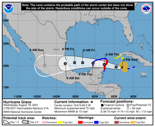
Hurricane Grace Discussion Number  21
NWS National Hurricane Center Miami FL       AL072021
1100 AM EDT Wed Aug 18 2021

Grace is becoming better organized on satellite images with a
comma-shaped cloud pattern, and the upper-level outflow remains
well defined.  Wind gusts well into the hurricane-force range were
measured on Grand Cayman earlier this morning, along with some
damage on the island.  Recent flight-level and SFMR observations
from both the Air Force and NOAA Hurricane Hunter aircraft support
sustained 65-kt surface winds, so the system is being upgraded to a
hurricane on this advisory.

Although Grace is situated over waters of very high oceanic heat
content, moderate northwesterly shear and only marginally moist
mid-level air could slightly impede intensification.  However,
some additional strengthening is expected before landfall tonight
or early Thursday.  Weakening will occur due to Grace's passage
over Yucatan, although that land mass has relatively low terrain.
Reintensification is anticipated over the Bay of Campeche on
Friday, and the system should regain hurricane strength before
reaching the east coast of mainland Mexico.  The official intensity
forecast is similar to the numerical model consensus.

Grace has been moving west-northwestward near 13 kt.  A prominent
mid-tropospheric ridge is likely to remain in place to the north of
the cyclone for the next several days.  This pattern should keep
steering Grace on a west-northwestward to westward track for 72-96
hours.  The track guidance models are in excellent agreement and
little change has been made to the NHC track forecast compared to
the previous few packages.

A Hurricane Watch will likely be required for a portion of the
coast of eastern mainland Mexico later today.

Key Messages:

1. Hurricane conditions and a dangerous storm surge are expected
in portions of the Hurricane Warning area in the eastern Yucatan
Peninsula of Mexico beginning late tonight or early Thursday.
Preparations to protect life and property should be rushed to
completion.

2. There is an increasing risk of hurricane conditions and dangerous
storm surge in portions of eastern mainland Mexico beginning late
Friday, and a Hurricane Watch will likely be issued for part of this
area later today.

3. Over the next few days, heavy rainfall across the Cayman Islands
as well as portions of the Yucatan Peninsula and Veracruz State
should lead to flash and urban flooding, with mudslides possible in
the Mexican state of Veracruz.

FORECAST POSITIONS AND MAX WINDS

INIT  18/1500Z 19.4N  82.2W   65 KT  75 MPH
 12H  19/0000Z 19.7N  84.5W   70 KT  80 MPH
 24H  19/1200Z 20.3N  87.6W   75 KT  85 MPH...INLAND
 36H  20/0000Z 20.6N  90.5W   50 KT  60 MPH...OVER WATER
 48H  20/1200Z 20.7N  93.2W   65 KT  75 MPH...OVER WATER
 60H  21/0000Z 20.7N  95.3W   75 KT  85 MPH
 72H  21/1200Z 20.5N  97.7W   60 KT  70 MPH...INLAND
 96H  22/1200Z 20.0N 103.0W   20 KT  25 MPH...POST-TROP/INLAND
120H  23/1200Z...DISSIPATED
1 -
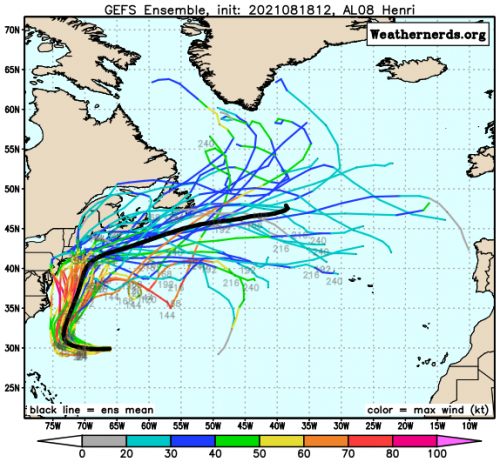
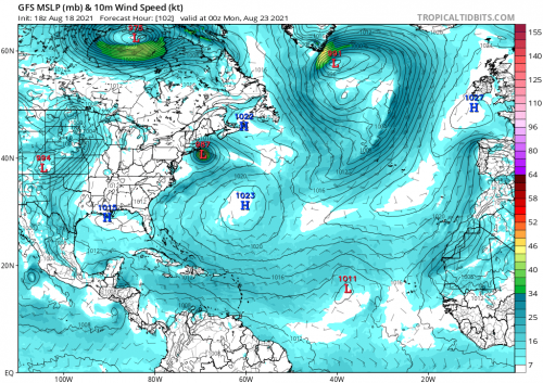
Henri has also formed south of Bermuda and is the 8th named system of the season. It too should become a low-end hurricane as it swings around northwards off the east coast of the USA over the weekend.
So far, this season, with 6 storms and two hurricanes, is lagging behind last year's active season, which at this point had seen 9 storms and 2 hurricanes. This week sees the climatological ramp-up of the season, peaking around September 10th.
1 -
Join Date:Posts: 11630
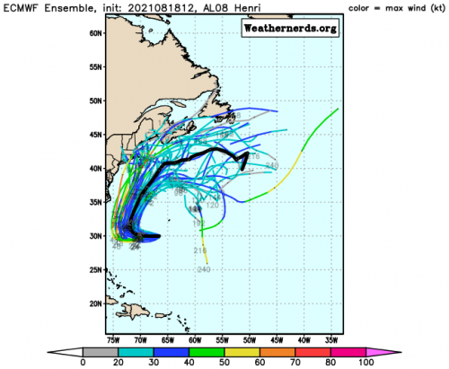
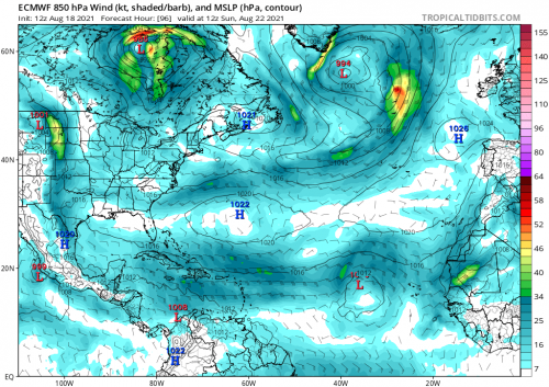
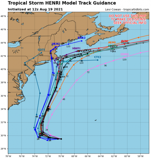
Interesting observations here about the strength and track of Henri .Commentators siding with the American models over the ECMWF for now regarding the strength . One to watch to see how it develops and if it comes near or impacts on the North East coast and always an added interest to see if any remnants feed into our weather.
GFS and ECM showing similar charts with HP blocking and steering in place but the ECMWF doesn't develop Henri as much as the GFS.
Will be interesting to see how strong it is before it hits colder water, would think tidal surge probably the main concern if it comes near to the coast.


 2
2 -
Join Date:Posts: 11630
Still a big spread on possible outcomes regarding Henri. Expected to reach hurricane force and travel up off the E coast . Trough over land ( West Vergina ) steering it from the S with HP off shore keeping on path moving up off the coast and all the interest on the HP currently over the great lakes set to move East and take up position to possibly steer Henri into New England and there lies the quandary, even with just 3 /4 days out it all depends on the Hp coming into place. Could happen that Henri slows over colder water off New England and weakens, it could still send in plenty of rainfall or it could move directly onto land as a possible weakening hurricane with strong winds initially , tidal surge and heavy rainfall. Commentators keeping this wide open. For now the remnants don't look to impact on our shores instead being taken up into Greenland.
 3
3 -
Join Date:Posts: 11630
Not 100% but confidence grows for Henri to take a westward track into New England. All the main models along with added data from the Recon missions and extra radiosonde launches are pointing more towards a landfall. Still speculation on the forward speed and how long it might spend over colder water. Storm surge and rainfall the main issues and wind speeds in coastal areas.
I see some commentators signaling out the UKMET as being very consistent also that the ground is already saturated so adding to the risk of flooding. The NHC has Henri slow to a crawl moving around 5 to 6 kts over Rhode Island which would only add to flooding problems.


 0
0 -
Long Island looks to be right in the firing line, though hurricane landfalls in that area are not entirely unheard of, with four occuring since 1950 and around 7-9 since 1900. Return period is around 17-19 years.

![strikes_us[1].jpg](https://us.v-cdn.net/6034073/uploads/VE0PDODNXXPV/strikes-us-5b1-5d.jpg)
 0
0 -
Join Date:Posts: 11630
Hurricane and Tropical Storm warnings from the NHC now . Main models continue to swing West and bunch more on track . Added issue of high tides with full moon this weekend.
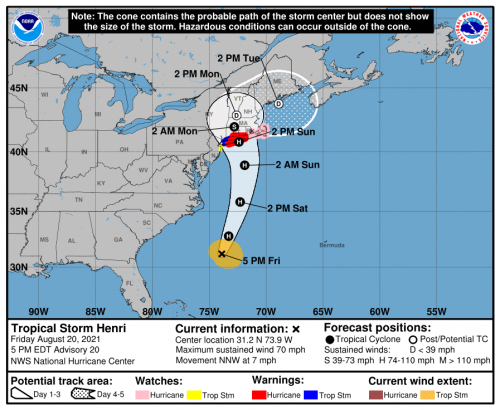
Key Messages:
1. Dangerous storm surge inundation is expected to begin Sunday in
portions of Long Island, Connecticut, Rhode Island, and
southeastern Massachusetts, where a Storm Surge Warning has been
issued. Dangerous storm surge is possible beginning Sunday in
western portions of Long Island and Connecticut in the Storm Surge
Watch area. Residents in these areas should follow any advice given
by local officials.
2. Hurricane conditions are expected to begin Sunday in portions
of Long Island and Connecticut, where a Hurricane Warning has been
issued. Hurricane conditions are possible Sunday across portions
of Rhode Island and southeastern Massachusetts.
3. Heavy rainfall may lead to considerable flash, urban, and small
stream flooding, along with the potential for widespread minor and
isolated moderate river flooding, over portions of Long Island and
New England Sunday into Monday.
4. Swells from Henri will continue to affect much of the east coast
of the U.S. through the weekend. These swells could cause
life-threatening surf and rip currents.
FORECAST POSITIONS AND MAX WINDS
INIT 20/2100Z 31.2N 73.9W 60 KT 70 MPH
12H 21/0600Z 32.8N 73.3W 65 KT 75 MPH
24H 21/1800Z 35.8N 72.3W 75 KT 85 MPH
36H 22/0600Z 38.9N 71.9W 75 KT 85 MPH
48H 22/1800Z 40.8N 72.4W 65 KT 75 MPH
60H 23/0600Z 42.0N 72.8W 45 KT 50 MPH...INLAND
72H 23/1800Z 42.9N 72.6W 30 KT 35 MPH...POST-TROPICAL
96H 24/1800Z 43.8N 68.9W 25 KT 30 MPH...POST-TROPICAL
120H 25/1800Z...DISSIPATED
$$
Forecaster Cangialosi
0 -
Henri being talked about in terms of 1991 Hurricane Bob though even tropical storms in that region do damage dumping lots of rain that saturates the ground allowing trees to be uprooted with winds of 45-65 mph.
Quite a bit of lightning to go with that system.

Net Zero means we are paying for the destruction of our economy and society in pursuit of an unachievable and pointless policy.
1 -
Latest IPCC report says hurricanes are demonstrating a poleward shift in their track, so that return period will reduce significantly
0 -
To paraphrase Beria, This is more of show me the storm and I will show you the cause . . . Catastrophic Anthropogenic Global Warming (CAGW)
Latest report?? That idea has been knocking around for decades. Based on their CAGW theory, most of the warming is expected to be in the higher latitudes, with little change in the tropical regions so don't expect any noticeable change in the frequency or intensity hurricanes. In fact the last 100 years of warming, with no change in frequency supports this conclusion. Theoretically, there might be a slight poleward shift in the track of hurricanes, but that would still be irrelevant when it comes to making decisions. It doesn’t matter if you average one hurricane in a region every 10 years, 15 years, or 20 years. You must still prepare for a hurricane every year. You still have to build your infrastructure to withstand that weather, that's why we tend to design around the statistical 100 year flood.
Net Zero means we are paying for the destruction of our economy and society in pursuit of an unachievable and pointless policy.
0 -
Advertisement
-
Maybe I should have put a trigger warning on my post. Some people are extremely reactionary whenever the IPCC are mentioned
1 -
Not wanting to turn this thread into another climate debate, but I note this paragraph in the report above.
The amount of poleward migration varies by region. The greatest migration is found in the northern and southern Pacific and South Indian Oceans, but there is no evidence that the peak intensity of Atlantic hurricanes has migrated poleward in the past 30 years
My maps on previous occurrences in the Long Island area were purely for information.
1 -
Go way out of that, you were fishing with your comment. Dont be coy when you hook one!
0 -
Henri now a Cat 1 75 mph but not looking as healthy as earlier on satellite. Cloud tops not as cold and shear shaving some of that off more than was anticipated?
0 -
Not a lot of change in convection since this morning, but it will be briefly passing over 30-degree waters tonight before much colder waters tomorrow.
The environment looks favorable for Henri to strengthen through tonight with low shear, upper-level divergence associated with the upper-level trough, and warm SSTs. In fact, SST analyses indicate that Henri will be passing over a patch of very warm 30 deg C waters this evening. By early Sunday Henri is predicted to cross the north wall of the Gulf Stream. That should result in some weakening, but Henri is forecast to be at or near hurricane strength at landfall. Once the center moves inland over the northeast United States, rapid weakening is expected. Henri is forecast to become post-tropical in about 48 hours and dissipate in 3 to 4 days.

 0
0 -
Join Date:Posts: 11630


NHC
Key Messages:

1. Dangerous storm surge inundation is expected to begin late
tonight or Sunday in portions of Long Island, Connecticut, Rhode
Island, and southeastern Massachusetts, where a Storm Surge Warning
has been issued. Residents in these areas should follow any advice
given by local officials.

2. Hurricane conditions are expected to begin late tonight or
Sunday in portions of Long Island, Connecticut, and Rhode Island,
where a Hurricane Warning is in effect. Tropical storm conditions
will begin in these areas tonight.

3. Heavy rainfall may lead to considerable flash, urban, and small
stream flooding, along with the potential for widespread minor to
isolated moderate river flooding over portions of Long Island, New
England, eastern New York and New Jersey.

4. Swells from Henri will continue to affect much of the east coast
of the U.S. during the next day or two. These swells could cause
life-threatening surf and rip currents.

FORECAST POSITIONS AND MAX WINDS

INIT  21/2100Z 36.3N  71.4W   65 KT  75 MPH
 12H  22/0600Z 38.8N  71.4W   70 KT  80 MPH
 24H  22/1800Z 40.8N  72.1W   60 KT  70 MPH
 36H  23/0600Z 42.1N  72.4W   40 KT  45 MPH...INLAND
 48H  23/1800Z 43.3N  71.9W   25 KT  30 MPH...INLAND
 60H  24/0600Z 43.6N  69.9W   25 KT  30 MPH...POST-TROP/INLAND
 72H  24/1800Z 44.3N  68.1W   25 KT  30 MPH...POST-TROP/INLAND
 96H  25/1800Z...DISSIPATED

$$
Forecaster Cangialosi
0 -
Thats the timeline I'm looking at
36H 23/0600Z 42.1N 72.4W 40 KT 45 MPH...INLAND
To see if Round 4 of the Northern Trust is going to take place or they just abandon the tournament after 3 rounds played...
0 -
The arse has fallen out of Henri a bit over the cold water before landfall. It's down to 50 kts on the latest advisory and webcams from the Hamptons to Nantucket show just breezy and wet conditions. The highest gust so far has been 69 mph on Point Judith, Rhode Island.
0 -
Tropical Storm Henri Tropical Cyclone Update
NWS National Hurricane Center Miami FL AL082021
1230 PM EDT Sun Aug 22 2021
...TROPICAL STORM HENRI MAKES LANDFALL ALONG THE COAST OF RHODE
ISLAND NEAR WESTERLY...
Data from an Air Force Reserve reconnaissance aircraft, NOAA Doppler weather radars, and surface observations indicate that the center of Tropical Storm Henri made landfall along the coast of Rhode Island near Westerly at approximately 1215 PM EDT this afternoon. At the time of landfall, maximum sustained winds were estimated to be 60 mph.
A Weatherflow station near Point Judith, Rhode Island, recently measured a sustained wind of 57 mph (92 km/h) and a gust to 70 mph (113 km/h). The center of Henri passed over Block Island, Rhode Island, around 1100 AM EDT...1500 UTC.
SUMMARY OF 1215 PM EDT...1615 UTC...INFORMATION
-----------------------------------------------
LOCATION...41.3N 71.8W
ABOUT 15 MI...25 KM NNE OF MONTAUK POINT NEW YORK
ABOUT 40 MI...65 KM SSW OF PROVIDENCE RHODE ISLAND
MAXIMUM SUSTAINED WINDS...60 MPH...95 KM/H
PRESENT MOVEMENT...NNW OR 335 DEGREES AT 12 MPH...19 KM/H
MINIMUM CENTRAL PRESSURE...989 MB...29.20 INCHES
0 -
Advertisement
-
The wind didn't actually knock him over, but funny to watch...
2


