Advertisement
If you have a new account but are having problems posting or verifying your account, please email us on hello@boards.ie for help. Thanks :)
Hello all! Please ensure that you are posting a new thread or question in the appropriate forum. The Feedback forum is overwhelmed with questions that are having to be moved elsewhere. If you need help to verify your account contact hello@boards.ie
Hi all,
Vanilla are planning an update to the site on April 24th (next Wednesday). It is a major PHP8 update which is expected to boost performance across the site. The site will be down from 7pm and it is expected to take about an hour to complete. We appreciate your patience during the update.
Thanks all.
50 Year Anniversary of 1962/1963 Winter in Ireland - A Day by Day Summary
Options
-
18-12-2012 5:41am#1I wrote this article on the winter of 1962/1963 a couple of years ago for IWO, but I think, since we are coming up to the 50th anniversary of this great winter, that it might be worth putting up on here for anyone who might have an interest in reading an account of the daily weather in Ireland during this infamous season.
Weatherwise, the 1960's was the decade to experience going by the records. Though it was generally cool statistically speaking, it was also a decade that saw some extreme weather events such as the winter 1962/63; 'Hurricane Debbie' in 1961; thundery summers with some severe events such as the 'Mount Merrion thunderstorm' on the 11th June 1963; windstorms; record breaking low temps etc etc. Anyway, I digress. Enjoy")
Winter 1962/1963
DECEMBER 1962
1st – 17th December 1962:
The opening days of December 1962 started calm and relatively mild, if foggy at times. By the end of the first week, however, it became increasingly stormy and wet with only the occasional brief incursion of cooler Polar air masses Mean temperatures for the period were near normal overall with winds mainly from south-west or west.
18th – 24th December 1962:
December 18th 1962 was a typically bright, fresh and breezy day with a few light showers drifting onto the west and north coasts. Unbeknownst to the nation however, a dramatic rise in mean sea level pressure (MSLP) over the cold plains of western Russia was being observed as an Arctic ridge of High Pressure began to extend down into North-Eastern Europe reaching 1030 hPa by the 20th.
Ireland, however, continued to enjoy its usual Atlantic weather with occasional bands of rain and showers crossing over in south-west to west winds which were quite fresh at times. Temperatures on the 20th rose above 10.0c with 11.7c being the max reading at Valentia Observatory, Co. Kerry; MSLP values averaged around 1005mb over the country. By evening, pressure began to rise from the south as a ridge moved in from the south-west.
MSLP values continued to rise overnight so that by the morning of the 21st, pressure readings over 1020.0hPa were being recorded across the country. Meanwhile, a cut off anticyclone was developing over Eastern Europe while the Azores ridge continued to surge north-eastwards to eventually amalgamate itself with the high pressure zone in Eastern Europe by the 23rd. Winds at this stage had backed to the SE over Ireland bringing in cooler, drier air from the near continent. Temperatures were beginning to drop and by the 24th, mean maxima hovered between 3c to 7c, with night-time frosts.
Over Europe, cold air from Russia was being fed westwards by the intense anticyclone that had developed in eastern Europe and as a result, snow and freezing temperatures became a problem over parts of the continent.
In France, 10 people died on Christmas day alone due to the intense cold while heavy snow caused much disruption for both locals and tourists in Perthus, close to the Spanish border. In Portugal, temperatures fell as low as -15.0c by night which barely rose above freezing by day. Switzerland was virtually cut off while it was noted that ice was forming in some coastal inlets around the Danish coast.
25th – 31st December 1962:
Christmas Day 1962 was a mostly cloudy day with some fog as a strong ridge of high pressure continued to hover over the country. By evening, a few snow flurries had drifted onto the east coast giving an ‘official’ white Christmas in some places but no disruption was reported. By early morning 26th, temperatures fell to -5.0c in some inland spots as skies cleared. Meanwhile, the strong anticyclone which had formed over NE Europe over the previous days was beginning to collapse rapidly while surface pressure began to increase to the north-west of Ireland with a cold, polar airstream bearing down over Ireland bringing an increased frequency in wintry showers along eastern coastal areas and by the 28th, there was a fairly widespread covering of snow parts of Leinster and Ulster.
On the 29th, winds increased from an easterly direction as pressure began to fall to the south-east, but it was a mainly dry, if cloudy day overall apart from a few coastal wintry showers. By evening, a deep low had begun to form in the Bay of Biscay as pressure continued to rise to the north-west of Ireland which had the effect of increasing the pressure gradient over Ireland markedly with winds increasing to gale force as a result, especially in eastern areas.
On the 30th, an occluded front crossed over the country bringing gale force easterly winds and heavy falls of snow to eastern and southern areas in particular. Blizzard conditions were reported over parts of Wicklow, Wexford, Cork, Waterford, Dublin, Kildare, Meath and Louth with drifts of up to 15 Feet recorded over the higher grounds of both Wicklow and Wexford. Sustained wind speeds remained unusually high for a good part of the day with gusts of up to 70mph being recorded at Rosslare. Many rural villages, especially those on higher ground, were cut off by the severe weather. In contrast, many parts of the west and north escaped with little or no snowfall although it was very cold and windy in these areas also.
Heavy and persistent snow showers continued to cause problems in the south and east on the 31st although winds eased, if only a little, during the day.
January 1963:
1st to 8th January 1963:
Many areas, especially in higher part of the east, were still cut off by the snowfalls in late December. On the 1st, strong easterly winds continued to push sleet & snow showers into Leinster and Munster especially. Max temperatures struggled to rise much above freezing although with the strength of the wind, minima was not especially low. There was, however, a considerable wind chill with winds gusting to gale force at times, especially near east coasts.
On the 2nd, strong easterly winds continued to buffet the country as a low pressure centre to the south of Ireland moved up against rising pressure to the north of Scotland. An occluded frontal feature lay near the south coast bringing cloudy weather with some light but persistent outbreaks of sleet and snow to Munster & South Leinster which hampered efforts to make roads passable in rural locations. Max temperature at Phoenix Park only reached 1.7c with 1.4c being the top reading at Birr. Again, the strength of wind prevented temperatures falling too low overnight.
The 3rd January saw no relent in the strong easterly winds as low pressure to the south of Ireland moved only slowly into the near continent. Snow showers continued to fall in counties Wicklow, Waterford, Wexford, Cork, Tipperary, Limerick, Kildare and Kilkenny which added to the already significant accumulations in these areas which further isolated rural areas. In Europe, it was reported that at least 500 people had died due to the intense cold that had set in during late December.
The 4th saw a general improvement over the hardest hit areas, with the frequency of sleet and snow showers considerably reduced as the low pressure over northern Europe began to fill resulting in much lighter winds over the country. Although some light showers of rain, sleet and snow were reported in parts of the south-east, there were no further accumulations which allowed operations to clear roads to continue uninterrupted. Maxima generally between 1.0c and 4.0c over the country on this day with no significant low minima reported. Some light showers continued on the 5th and 6th with some longer outbreaks of rain and sleet in the south later on the 6th but in general, conditions continued to improve over the country although temperatures by day remained on the cool side of average.
By the 7th, easterly winds were beginning to increase significantly once again. This had the effect of giving a considerable wind chill as daytime temperatures struggled to reach above 3.0c in many areas. Gale gusts were reported in many eastern coastal areas with occasional rain, sleet and snow showers in these parts. On the 8th, an occluded frontal feature approached the south-west as winds veered to the south-east and continued strong over the country with precipitation falling mainly as rain and sleet, with some snow on high ground. Max temperatures were still cold for the time of year ranging between 1.0c inland and to the west and 4.0c to 6.0c near south and east coasts allowing the slow thaw to continue.
January 9th - 18th 1963
January 9th was another cold, windy day with max temperatures averaging around 3.0c over the country. A deepening depression to the south-west of Ireland began to intensify as another strong ridge of high pressure was beginning to extend down over Scotland from a primary anticyclone over Iceland keeping the isobaric gradient tight over Ireland. Winds gusted to gale force over much of the country with high seas and some coastal flooding reported along some eastern coastal areas but wintry showers remained isolated and light in nature. Mean minima feel close to 0.0c during the evening but the strong winds prevented any significant frost developing.
The 10th and 11th January continued cold and windy with a few isolated wintry showers near northern and eastern coasts. Temps ranged between 2.0c and 4.0c by day and by -4.0c to 2.0c by night. Strong easterly winds once again prevented minima falling too significantly.
The period 15th - 17th saw winds finally easing as an intense ridge of high pressure to the north moved down over Ireland. The consequence of this was lower temperatures across the country. In parts of the midlands and west, daytime maxima struggled to reach 0.0c while night-time minima fell to their lowest levels of the entire winter period. On the 13th, minima fell to below -8.0c in many locations with the lowest temperature of the season, -11.6c, being recorded in Birr in Co. Offaly.
The 18th January saw easterly winds increasing over the country once again which gusted to gale force along eastern and southern coasts. Light snow showers affected midland & eastern areas. Daytime temps averaged around 3.0c over the country but coupled with the strength of the east wind, it felt much colder. On the 19th, the intense anticyclone to the north or Ireland moved a little further north which destabilised the strong easterly airflow over Ireland a little. Snow showers continued to feed into eastern areas as a sharp frost developed widely by nightfall despite the strong winds.
By the 20th, heavy and persistent snow showers affected much of the country with temperatures only just above freezing point. In counties Cork and Waterford, 6 feet drifts were reported as wind driven snow persisted. In Roscommon, a foot of snow fell during the afternoon while in Donegal, a blizzard raged for many hours. The east midlands were particularly badly hit with roads around the Mullingar region made impassable by heavy snowfalls. Snow showers continued into the evening and night and despite the strong easterly winds, temperatures fell to between -4.0c and -6.0c inland giving a penetrating frost.
The period 22nd-29th was relatively calm and very sunny as a strong Anticyclone settled over the country. It remained very cold with daytime temperatures averaging around 2.0c to 4.0c with a rise toward near normal values later in the period spurring on a slow thaw, although night time minima fell close to -10.0c in parts of the east. Dense fog was also a problem at times. Later on the 29th, weak frontal troughs to the north began to move towards Ireland.
January 30th saw a band of light rain with relatively mild temperatures move down over the country in a light to moderate NW wind. Once the rain cleared, winds increased and quickly turned to the north-east along with falling temperatures. This brought a renewed surge of sleet and snow showers to northern and eastern coastal districts. On the 31st, sleet and snow showers continued in some eastern areas before filtering further westwards into parts of Munster and Connacht and as a result, snow was lying over a wide area by nightfall. It became frosty again despite an increasingly strong east wind.
Monthly Mean Sea Level Pressure for January 1963: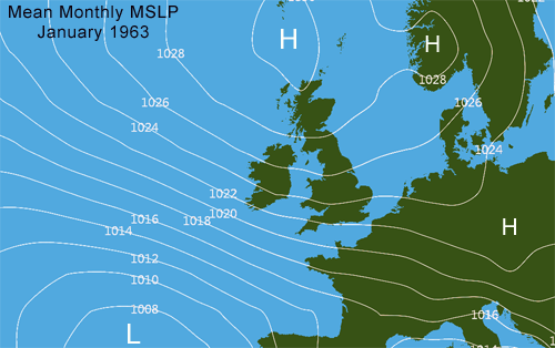
Data from ERA 40/ECMWF
February 1963:
1st-7th Febraruy 1963:
On the 1st and 2nd February, Mean Sea Level Pressure values remained very high to the north-west of Ireland while as values began to fall over central and southern Europe. Moderate to fresh easterly winds continued over Ireland but apart from a some coastal sleet and snow showers in eastern coastal counties, which were persistent enough to give renewed accumulations on high ground, it was generally dry if cold. Daytime temperatures averaged 2.0c to 4.0c while nights continued very cold and frosty with values ranging between 1.0c and -5.0c.
On the 3rd, a weak cold front moved down over the country from the north giving some light outbreaks of freezing rain, sleet and snow which resulted in very dangerous driving conditions across the country. Winds backed to the north-east and remained moderate to fresh. This did not prevent a hard frost setting in after dark with -8.7c being recorded at Birr.
The 4th saw sleet and snow showers becoming widespread as a vigorous polar depression moved down along the west coast. Winds increased further causing considerable hardship especially to those living on higher ground. Parts of Wicklow, Kilkenny, Kildare, Waterford, Offaly, Limerick and Galway were the worst hit areas and although temperatures did rise above freezing point during the day, a hard frost quickly set in after dark once again.
The period 5th-7th February saw temperatures rising a little as a deep depression anchored itself near the south-west coast. Although there was some sleet and snow reported in northern most areas, with some heavy falls with blizzard conditions on the 6th, most of the precipitation fell as rain which, coupled with the gradual return to milder temperatures, helped to initiate a general thaw over the country. Winds were strong at first but slackened later in the period. Frost, however, still occurred by night inland which made conditions dangerous for driving and other outdoor activities.
7th - 15th February 1963:
By the 8th, milder weather had become well established over the country with daytime temperatures averaging around 8.0c or 9.0c. Valentia Observatory recorded 9.8c during the afternoon. Bands of heavy rain and showers moved up over the country from the south-west with thunder reported in some southern and western areas. However, by the 9th, a ridge of high pressure was beginning to intensify over Scandinavia and by the 10th, a strong, cold easterly wind became established once again as the low pressure which brought the milder weather to Ireland began to slip south and fill. Rain, which continued in southern most counties, gradually turned to sleet, especially on higher ground.
Both the 11th & 12th February were cool, cloudy days overall but strong east winds had eased a good deal. Some isolated light sleet and snow flurries along the east coast at times but dry weather predominated. Max temperature at Birr only reached 0.8c on the 11th and 2.0c to 4.0c over the rest of the country. However, cloud cover prevented min temperatures falling too low by night.
On the 13th, winds veered to the southwest as Atlantic fronts edged in from the west bringing with them much milder air and heavy rain, which fell as sleet and snow for a time as they pushed north-eastwards. Maxima averaged between 7.0c and 8.0c over the country with 9.4c reported at Valentia Observatory. Mild weather prevailed on the 14th & 15h with flooding reported due to melting snow causing significant problems in the north especially.
16th-20th February 1963:
This milder weather did not last, and by the 16th, winds had backed to the east once again as low pressure in the Atlantic was forced southwards but by a strengthening upper ridge south of Greenland. Weak frontal troughs off the south coast brought rain at first which turned increasingly to sleet and hill snow as temperatures started to drop once again. Average maxima ranged from 3.0c in the north to 6.0c in the south. Winds were moderate easterly but cloud prevented frost forming after dark.
The period 17th and 19th continued in the same vain. Weak frontal features near the south and south-west coasts brought a little rain, sleet and snow at times, particularly near south and east coasts but generally the weather was dry if cloudy. Fresh, and at times strong, east to south-east winds predominated making the average max of 4.0c and average min of -2.0c feel particularly cold and raw.
20th- 28th February 1963:
The period 20th to 23rd of February saw winds easing a good deal as a weak ridge of high pressure moved closer to Ireland from the north-west. Still a few sleet and snow flurries near eastern and northern coasts at first but dry and mostly sunny weather prevailed. Daytime temperatures reached near normal values but night time frosts became increasingly severe.
On the 24th, it became increasingly hazy as winds backed to the south-east and strengthened a little as the ridge of high pressure moved in over the continent. A good deal of cloud overall as weak fronts hovered near the south-west coast but it remained dry. Daytime temperatures fell back to an average of 6.0c but frosts became less of a problem. Little change on the 25th apart from some patchy light rain in western coastal counties as winds increased even further.
The period 26th-28th saw dry, breezy weather predominate as an intense anticyclone became slow moving over northern Europe drawing in a continental east to south-east wind over Ireland. A good deal of cloud overall but temperatures recovered once again to near normal with any frosts being light and patchy at best.
March 1963:
Although the cold spell did not end until the middle of March, the severity of it eased a good deal as a gradual return to a more normal Atlantic weather regime took place.
Some headlines from this winter, via the Irish Times Archive.
Dec 28th 1962
Headline from the 31st December 1962 on the blizzards in the southeast:
From the 3rd January 1963:
Forecast from the then known 'Meteorological Service of Ireland' on the 8th January 1963:
Monthly Summary from the Meteorological Service of Ireland for January 1963, published in early February 1963:
Patrick/Deep Easterly/Loser
Temperature and rainfall data the ECA&D & The Meteorological Service of Ireland.
Newspaper clippings from The Irish Times Archive.
Chart Data from ERA 40/ECMWF43
Comments
-
Many thanks Deep Easterly, a very interesting read!

D0 -
Maybe most of what I heard about 62/63 is from a UK perspective or something but I don't remember ever seeing the words, rain, sleet, thaw and positive maximas during the day mentioned so often in my limited reading on it previously.
It dunno, I always had the impression it was 3 months of deep snow and frozen lakes and rivers or something.
Would I be correct in saying that it was more like a week of '82, a week of '87 and a few February '09's spread out over Dec/Jan/Feb with a few weeks of thawed wet mildness separating all of them??
ie. Still a legendary Winter for Snow and Cold Lovers but a different kind of legendary?0 -
Would I be correct in saying that it was more like a week of '82, a week of '87 and a few February '09's spread out over Dec/Jan/Feb with a few weeks of thawed wet mildness separating all of them??
I wouldn't think so. Winter 1962-1963 would be more similar to the winter of 2009-2010 with consistently cold days over a well extended period. One difference is that 62-63 was a far more 'continental' winter and also consistently breezy with very low relative humidifies whereas 09-10 was almost exclusively maritime and far calmer with higher RH's as a result, so though fairly similar in terms of temperature, winter 62-63 would have felt far more brutal to that of 09-10, IMO at least.0 -
I saw the piece on Met.ie about the 50th anniversary of the Mount Merrion thunderstorm (http://www.met.ie/news/display.asp?ID=206). The footage supplied by Helen Carroll at the end of the article is particularly interesting but I can't figure out where the location of what looks like a waterfall is. I assume it's the disused rail line but where exactly?0
-
youguessedit wrote: »I saw the piece on Met.ie about the 50th anniversary of the Mount Merrion thunderstorm (http://www.met.ie/news/display.asp?ID=206). The footage supplied by Helen Carroll at the end of the article is particularly interesting but I can't figure out where the location of what looks like a waterfall is. I assume it's the disused rail line but where exactly?
Wrong thread.
This was discussed at the time. The waterfall is over the old abutments of the now removed railway bridge at Dundrum cross, roughly where the Luas suspension bridge is now to be seen.0 -
Advertisement
-
Many thanks, Larbre34. I'll have to get my hands on an old map to place it properly. Can only find one other thread (http://www.boards.ie/vbulletin/showthread.php?p=85028619, with a post from yourself). Would you remember where the more relevant thread is?0
-
youguessedit wrote: »Many thanks, Larbre34. I'll have to get my hands on an old map to place it properly. Can only find one other thread (http://www.boards.ie/vbulletin/showthread.php?p=85028619, with a post from yourself). Would you remember where the more relevant thread is?
This is the post you're looking for I think http://www.boards.ie/vbulletin/showpost.php?p=53473066&postcount=25
The OSI Map Viewer will give you access to a selection of historic maps via the menu on the right0


Advertisement